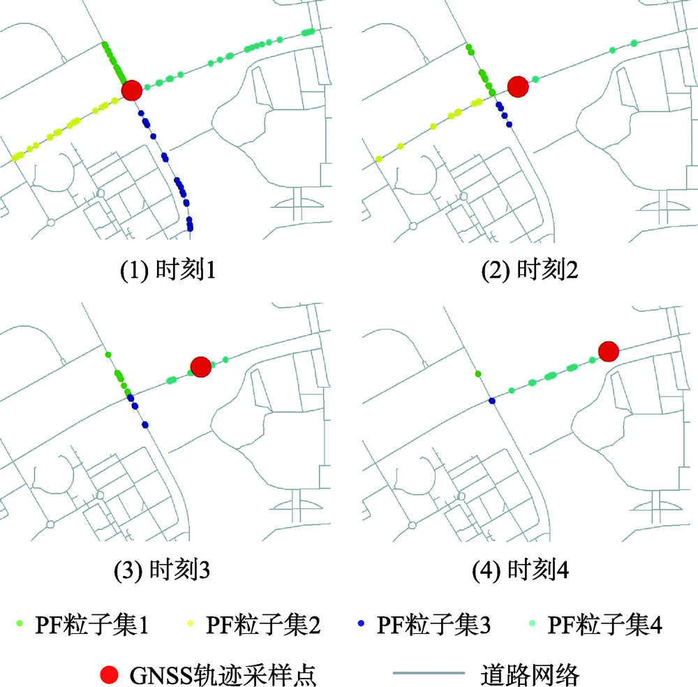
Vehicle trajectory is a time series geospatial location sampling data. The traditional vehicle trajectory-map matching methods are mainly computed by ways of global or local incremental optimization, which limited the relative independence in matching process of the trajectory data in spatial temporal situation. To address this problem, this paper proposes the method of computing matching relationships between vehicle trajectory and road map based on the Particle Filter (PF) method. First, construct the road network from the road dataset, and search the neighboring nodes from the road network based on the vehicle sampling locations along the moving direction that are detected from the vehicle trajectory. Then, construct the motion model based on the vehicle trajectories, randomly generate particles on the road arcs that are related to the searched nodes, and move the particles along the sampled road segments according to the trajectory motion model. Second, compute the motion states of the particles according to the motion model in each time state, get the distance errors between the particles and the vehicle position sampling locations, obtain the particle weights based on the Gaussian probability density function, resample particles based on the random resampling method, and then update the motion states of particles iteratively. Finally, compute the accumulated weights of the particles in each of the topologically related road arcs, which are searched by the neighboring nodes, and calculate the matching relations between the vehicle trajectories and the map based on the accumulated weights of the particles. With this method, the experiments were conducted based on the vehicles' trajectories, which were two long sequenced trajectories with the total length > 102 km. The results showed that 85.51% and 93.01% correctness rates of vehicle trajectory-map matching experiments had been achieved for each of the vehicle trajectories. Besides, the motion of the vehicle sampling locations could be reflected by the spatial-temporal movements of the particles, where particles started to follow the motion of the vehicle sampling locations after a few time states. The results showed that it could achieve the accurate matching relations between the vehicle trajectories and the road map.
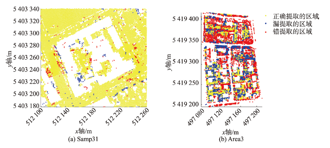
Existing filtering algorithms based on airborne LiDAR data have many disadvantages, e.g., they fail to make full use of all the information of the LiDAR data, and their data structures are complex or suffer from information loss. In this paper, we proposed an airborne LiDAR 3D filtering algorithm based on the grayscale voxel structure segmentation model. The proposed algorithm ?rst regularizes a given LiDAR point cloud into a grayscale voxel structure to comprehensively utilize the elevation and intensity information of the LiDAR data, in which the voxel's grayscale denotes the discretized mean intensity of LiDAR points within the voxel. Then, the constructed grayscale voxel structure is segmented into multiple 3D connected regions depending on the spatial connectivity and grayscale similarity among voxels. Finally, the 3D connected regions corresponding to ground objects are detected based on elevation differences. The proposed algorithm has the following advantages. (1) It is designed based on the grayscale voxel structure and is a 3D filtering algorithm. (2) The average completeness, correctness and quality of the proposed filtering algorithm for dataset 1 with 0.67 points per square meter were 0.9611, 0.9248, and 0.8934. The average completeness, correctness and quality of the proposed filtering algorithm for dataset 2 with 4 points per square meter were 0.8490, 0.8531, and 0.7404. (3) Its filtering result is in the form of the 3D ground voxel, which can be directly used for creating a 3D model of ground. The sensitivity of "spatial adjacency size" parameter in the model and the validity of the proposed algorithm is analyzed by using two airborne LiDAR benchmark test datasets of different densities provided by the International Society for Photogrammetry and Remote Sensing (ISPRS), and the accuracy of the proposed filtering algorithm is compared with that of the other classical filtering algorithms. Our experimental results of quantitative evaluation show that: (1) The 56-adjacency was the optimal adjacent size. (2) The average completeness, correctness and quality of the proposed filtering algorithm for dataset 1/2 with 0.67/4 points per square meter were 0.9611/0.8490, 0.9248/0.8531, and 0.8934/0.7404, respectively. (3) Compared with other classical filtering algorithms, the proposed algorithm performed better in high-density point cloud data filtering.
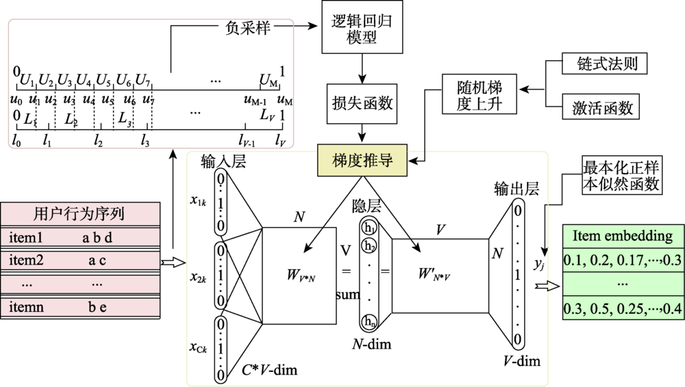
Establishing a user preference recommendation model suitable for thematic map product search is one of the effective ways to improve the quality of the thematic map products. In the thematic map product recommendation scenario, there are serious problems of content cold-start and sparse comment data. The existing recommendation algorithms cannot recommend thematic map products with different features for specific types of users, resulting in users' limited preference for obtaining preference information from the thematic maps. Hence, this paper presents a user preference recommendation method based on the combination of CBOW with Negative Sampling and Iten2Vec based on Word2Vec. Firstly, calculating implicit ratings of the interaction behavior data in the user behavior log, to replace sparse user ratings in thematic disaster scenarios; Secondly, extracting context-aware feature information of central thematic map based on CBOW model with Negative Sampling. By controlling the ratio of positive and negative samples to 1:2, the prediction accuracy of the potential score of the target thematic map is improved; Finally, mapping Thematic CMaps with user behavior characteristics information to vector space via Item2Vec, calculating the user's similarity matrix to the thematic map and completing recommendations based on user preference. Test results on thematic map scoring experiment dataset Thematic CMaps and four validation dataset MovieLens show that, compared with the four traditional recommendation algorithm of LFM, Personal Rank, Content Based, and SVD, this proposed method can effectively improve the precision potential scoring, and the highest recommending performance is 27.85%. Compared with Item2Vec with Huffman sampling method and YouTubeNet two neural network recommendation algorithms, the score prediction accuracy has improved to a certain extent, and the recommendation performance has been continuously improved, reaching the maximums of 2.97% and 5.78%. Taking the singular value decomposition (SVD) of the classic algorithm as an example, in the increasing data subset after the segmentation of MovieLens-20M dataset, the score prediction accuracy and performance of the method used in this paper are better than SVD method.
Rapid urban expansion has brought disorder and low efficiency to the socioeconomic development and the land utilizatopm. However, due to a large number of scale-free phenomena in the urban complex system, it is difficult to measure its morphological characteristics effectively. In essence, fractal is a hierarchical system which is related to the complex network cascade structure. Fractal structure can be used to measure the spatial cycle subdivision of urban geographic system, which plays an important role in the exploration on the law of urban morphology evolution, and provides an effective mathematical tool for the implementation of territorial spatial planning. Based on the urban fractal theory, this paper forms a logical frame for the evolution of urban functional land, through the dual analysis of the radial dimension and the grid dimension representing urban spatial form. By calculating and analyzing the empirical case of Zhengzhou, a typical representative of urban growth and evolution in China, the validity of using the second derivative to automatically identify the scaling range in the radius method is verified. Finally, the paper discusses the structural and functional problems hidden in the urban evolution process, and provides theoretical reference and method enlightenment for the exploration of integrated optimization scheme of the fractal urban system. The results show that: (1) Using the second derivative method to automatically identify the boundary of scaling range in the radius method can significantly improve the feasibility of the fractal model. The fitting accuracy R2 is increased from 0.920 to above 0.996. This method makes a breakthrough attempt on the application bottleneck in the fractal model of radius method, which is difficult to improve the fitting accuracy. This method has obvious advantages in simulating the urban growth, especially the evolution of urban spatial structure, and can judge the expansion speed and mode, so as to evaluate the city's health. (2) The double scale phenomenon exists in the urban spatial structure of Zhengzhou. The radius method model only fits effectively in the circular range of "the edge of urban center-inside the built-up area", which may have the growth characteristics of self-affine or random multi-fractal. (3) From 1982 to 2020, the urban form of Zhengzhou evolves into a central sprawl mode, and the urban center and the periphery present a dualistic trend. The interaction between the systems is insufficient, the system efficiency is lower, and the urban spatial structure can be further refined and upgraded.
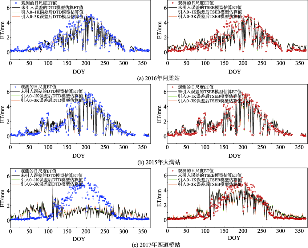
Operational application of an appropriate model to estimate evapotranspiration (ET) and the components evaporation (E), transpiration (T) at a range of space and time scales is very useful for managing water resources. The Two Source Energy Balance (TSEB) and Dual Temperature Difference (DTD) models have been applied to estimate land surface evapotranspiration under various landcover types and environment conditions. The DTD model requires twice radiometric temperature observations as inputs while the TSEB model only use single observation. This may reduce the uncertainty of DTD model which introduced from the observation or remotely sensed based radiometric temperatures. However, the two models may perform inconsistent under various land surface, which mainly associated with the different theoretical mechanisms in the models. In this study, the two models were evaluated using the long time ground observation data collected from three total different landcover types and environment conditions, including alpine grassland, semi-arid irrigated farmland and arid riparian forest in Heihe River Basin in Northwest China. The results showed that the latent heat flux estimated by the DTD model had a better agreement with half an hour ground measurements at the alpine grassland site, with the RMSE value of 62.00 W/m2, while TSEB model showed a higher RMSE value of 75.49 W/m2. But the performance of the two models was associated with the variation of the vegetation coverage. While, in the semi-arid farmland site, the performances of two models were more consistent where they produced a closer RMSE values, but in the arid riparian forest site, both of the models significantly underestimated the latent heat flux. The DTD model showed a worse agreement with the ground measurements in both sensible and latent heat fluxes. The DTD modeled latent heat flux had a higher RMSE values of 136.74 W/m2 where the TSEB model had a RMSE value of 86.40 W/m2. The better agreement of the TSEB model latent heat fluxes may associate with greater underestimation of modeled sensible heat flux which can partly compensate underestimation of net radiation. However, at the daily scale the performances of the DTD model and TSEB model were more similar. Additionally, the ratio of plant transpiration to evapotranspiration partitioned by the two models were in good agreement with results simulated from water use efficiency (uWUE) model with ground measurements, while the DTD model also performed better than the TSEB model. Finally, the TSEB model was more sensitive to the model input of land surface temperature. Therefore how to improve the accuracy of remote sense land surface temperature products is vital to the model application. Meanwhile, future researches can focus on optimizing model for extending applications over heterogeneous surface and different meteorological conditions.
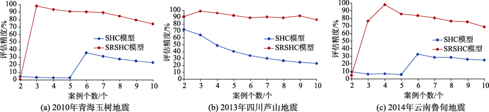
Earthquake is one of the most serious natural disasters for our human existence, and often causes huge losses. Disaster assessment based on similar historical cases is useful for disaster analysis and quick policy making when detailed real disaster data are not available. Based on the framework of the Assessment Method of Natural Disaster Based on Similarly Historical Cases (SHC model), this paper constructs the Spatial Reasoning of Similarly Historical Cases (SRSHC) model for earthquake casualty assessment, which considers the spatial relevance of historical cases to current disasters. We select earthquake magnitude, focal depth, and time of earthquake to describe the characteristics of an earthquake and use a similarity assessment model based on Manhattan distance to evaluate its similarity to historical cases. Besides, this paper introduces the distance of earthquake fault to quantify the spatial correlation between historical cases and current disaster. In this study, earthquake disasters with a magnitude of 4.0 or above in China from 2000 to 2013 are selected as historical cases. Three representative cases are chosen for accuracy verification, including the Yushu earthquake in Qinghai in 2010, the Lushan earthquake in Sichuan in 2013, and the Ludian earthquake in Yunnan in 2014. Results show that: (1) For the three verification cases, the accuracy of the SRSHC model is all above 95%, indicating that the model has certain feasibility and applicability in assessment of earthquake casualty; (2) Compared with the SHC model, the SRSHC model requires fewer participating cases but higher accuracy. For example, for the Yushu earthquake, when the number of participating cases is three, the accuracy of the SRSHC model reaches highest (97.92%). While the SHC model requires six participating cases to reach the highest accuracy (35.49%). It reveals that the spatial correlation between historical cases and the current disaster has a great impact on the evaluation of results; and (3) The accuracy of the disaster assessment model is related to the number of participating cases. When there are more than two participating cases, the accuracy of the model assessment decreases with increasing number of participating cases. When the number of participating cases is three or four, the accuracy of the SRSHC model is the highest. In conclusion, the advantages of the method developed this study are low cost, high efficiency, timely effectiveness, its simplicity, less constraint, and easy to implement, which has certain practical value and prospects in disaster assessment.
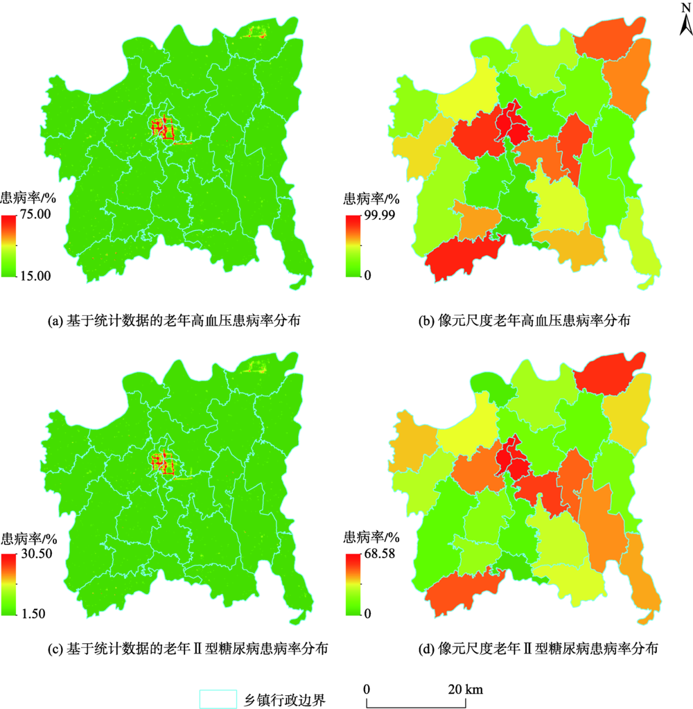
The prevalence of elderly hypertension and type 2 diabetes diseases have a strong positive correlation with regional socioeconomic development. As nighttime light images can reflect the regional socio-economic development directly, the application of nighttime light data to study of diseases in the elderly become very significant. Selecting Changning City as the study area, this paper analyzed the difference in spatial distributions of the prevalence of elderly hypertension and type 2 diabetes among 26 townships based on the Luojia1-01 nighttime light data and the prevalence rate data of these two diseases in the study area. The spatial distribution of the prevalence of these two diseases in the study area was simulated by linear regression models. Results show that: (1) The correlation between mean nighttime light values and prevalence of hypertension or type 2 diabetes was stronger than that between total nighttime light values and prevalence of hypertension or type 2 diabetes. The relationship between mean or total nighttime light values and prevalence of hypertension was weaker than that between mean or total nighttime light values and prevalence of type 2 diabetes in the elderly; (2) The impacts of mean nighttime light on the distribution of the both diseases were larger than that of total nighttime value. And both the mean and total nighttime light had larger impacts on the spatial distribution of type 2 diabetes; (3) The risk of the elderly living in areas with high nighttime light was 6.493 times higher than those living in areas with low nighttime light, with the OR value for type 2 diabetes was 8.556; and (4) The linear regression model between the prevalence of either elderly hypertension or type 2 diabetes and mean nighttime light showed a high accuracy, which could accurately predict the spatial distribution of the prevalence of hypertension or type 2 diabetes of the elderly in the study area. Our research results can provide reference for the application of nighttime light data in disease researches and the analysis of the causes of regional hypertension and type 2 diabetes diseases in the elderly, as well as the investigation and prediction of similar diseases.
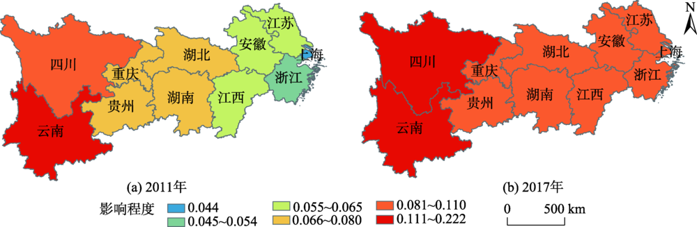
As a new driver of economic growth, urban-rural integration is a key way to build an efficient energy economic system and balance economic and social development with ecological environmental protection. Analyzing the effect of urban-rural integration on energy efficiency is important to promote sustainable economic and social development. In this paper, we took the provinces of the Yangtze River Economic Belt as the research object. We used the DEA values to measure the energy efficiency and analyzed its differentiation characteristics over time and space. The level of urban-rural integration was evaluated by a comprehensive index system of economy, society, and infrastructure. Based on these, Moran's I index was used to determine the spatial correlation of energy efficiency, urban-rural integration level, and other influencing factors. Finally, the urban-rural integration and three control variables were estimated by mixed geographically weighted regression to analyze the spatial effect. Based on spatial correlation analysis, the urban-rural integration level of the Yangtze River Economic Belt had a positive effect on energy efficiency. Economy development level and industrial structure also had positive impacts on energy efficiency. However, technological progress was negatively correlated with energy efficiency. Based on estimated regression coefficients, the impact of urban-rural integration on energy efficiency was smaller than technological progress and industrial structure, and economic development level had the least impact on energy efficiency. The positive impact of urban-rural integration level on energy efficiency showed a trend of first increasing and then decreasing with the increasing of energy efficiency, and an spatial pattern of increasing from east to west. The energy efficiency of the Yangtze River Economic Belt presented significant spatial correlation and spatial heterogeneity. Our study demonstrates a significantly increasing energy efficiency result from the process of urban-rural integration in the Yangtze River Economic Belt.
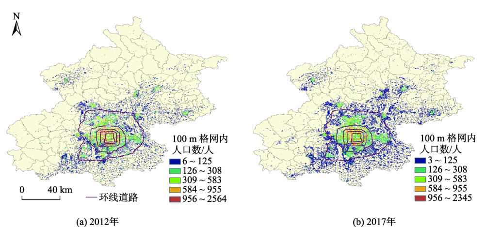
High-precision spatially-explicit population data performs a quantitative reference for evaluating urban resources and environment pressure and promoting a rational population distribution. This study first classified and ranked street blocks of Beijing based on land use categories and VANUI index. Based on this, a hierarchical population spatialization model was built to generate the spatial distribution of population at 100 m resolution. In addition, Beijing permanent resident demographic information of 2012 and 2017, NPP/VIIRS nighttime lights data, land use, road networks, and other auxiliary data were also used as model inputs. In our study, the model simulation error against the verified data was less than 10%. Compared with other published results, the population distribution result generated in this study had a higher overall accuracy and local accuracy. We further analyzed the spatio-temporal pattern of population in Beijing and its impact factors. Results show that the population of Beijing in each 100 m grid varied from -2564 to 1904, with -500~500 being the main change level. The spatial patterns of population in 2012 and 2017 both demonstrated that central Beijing was densely populated while Beijing suburb was sparsely populated. Between these two years, population of Beijing declined by approximately 210,000, which mainly happened in six main districts. The core functional area of Beijing had a remarkable reduction in population, accounting for 62% of the total population decline within the six districts of the city. In addition, population between the second and third ring of Beijing decreased the most, with nearly 110 000 people moved out, accounting for 52% of the population decline within the six districts. On the contrary, the population increased in the surrounding street blocks at the border of the six districts, which might form new population centers in the future. The spatial and temporal dynamics of Beijing's population were closely related to factors, such as the functional orientation of the capital, industrial upgrading and transformation, and the implementation of population redistribution policies. This study provides a scientific reference for the rational layout of Beijing's population space and formulation of Beijing's population redistribution policies in the future.
The delimitation of urban growth boundaries is of great significance for ensuring the rational use of resources and promoting the orderly development of cities and towns. Most existing studies mainly focus on the technical exploration of planning practice, while ignoring the quantitative assessment of the ecological environment to some extent. In addition, few studies have been carried out at the metropolitan area scale. This study takes Wuhan Metropolitan Area as the study case, and proposes to combine multiple factors to build a "dual environment evaluation" system. The FLUS model is used for land growth simulation and delineation of urban growth boundaries. Furthermore, the results are analyzed using the landscape metrics. The results show that: (1) the FLUS simulated urban area expansion demonstrates an applicable accuracy. The simulation results reveal that the urban built-up areas keep expanding, so it is necessary to delimit the development boundary to restrict urban development; (2) The delineated urban growth boundaries can prevent from urban construction occupying areas with high ecological or agricultural value, and improve the urban spatial layout of the Wuhan Metropolitan Area based on the optimization of spatial forms with strong applicability; (3)The evaluation of urban expansion driving factors shows that compared to a single factor library, the "dual environment evaluation" factor library has a higher accuracy, can optimize the landscape pattern, promote the development of construction land, and fill the gaps in the built-up area better, which is corresponded with regional development requirements; and (4) The evaluation of expansion analysis shows that the results are consistent with the expected development pattern of Wuhan Metropolitan Area, and government departments might pay attention to the potential value of the expansion in the airport region, the Yangluo region, the Optics Valley-Future City region, and the Zhifang region. The above shows the effectiveness of the FLUS model in the Wuhan metropolitan area, which also provides great reference for planning management and construction land optimization.

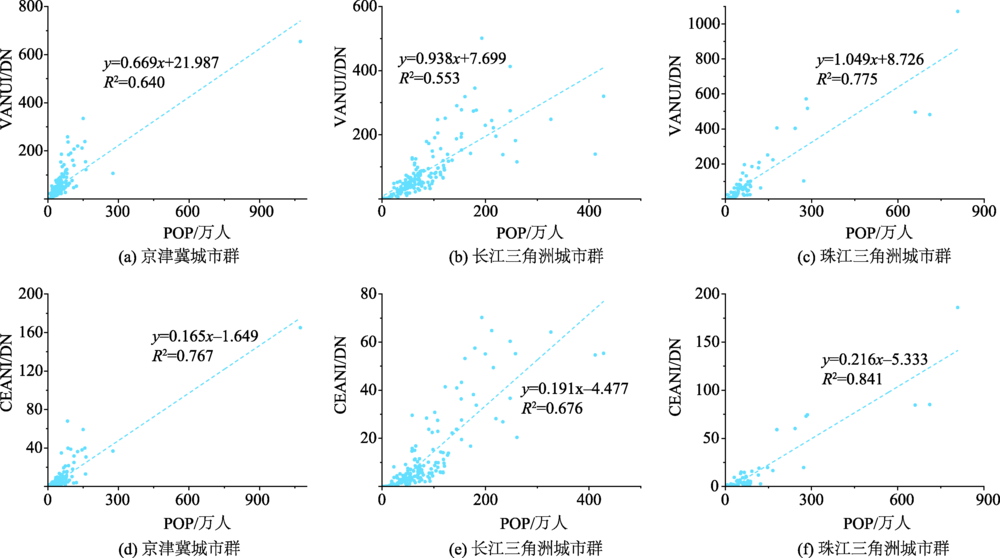
The lack of gain recording and cross-calibration during the OLS sensor navigation makes DMSP nighttime lights image oversaturated in the city center, which affects the accuracy of using night light data to evaluate human activity intensity. In order to suppress the occurrence of saturation, the radiometric calibration night light data developed by Elvedge have been widely used. The radiometric calibration data products have a high accuracy and strong reliability. However, the calibration process is complex, and the required data is usually difficult to obtain. At present, only a few results have applied the calibration data to the continuity analysis. In recent years, many scholars found that NDVI can desaturate DMSP/OLS night light images and enhance the heterogeneity of urban center. Based on this, non-radiation calibration method has been applied to correct the saturation effect and shown a good correction result. On the basis of summarizing the idea by VANUI that the difference between night light intensity and vegetation coverage shows a decreasing trend from the city center to the suburb, this paper considers that the population density increases exponentially with the increase of rural-urban distance. We proposed a correction of nighttime light index based on compound exponential model (CEANI). Results show that (1) compared with VANUI, CEANI showed better details and spatial heterogeneity when characterizing the saturated regions of the city. In addition, CEANI not only identified areas where human activity was concentrated, such as stations, airports, and business areas with high traffic and people flow, but also clearly identified the areas with high vegetation coverage and low DN values such as forests and parks with sparse road network; (2) in the correlation analysis using 25 random samples, CEANI showed a higher correlation (R2mean = 0.79) with radiometric calibration products than VANUI (R2mean = 0.68); (3) CEANI had a stronger correlation with the number of permanent residents and significantly estimated population indicators better than VANUI, which suggests the better calculation index for describing the intensity of human activity. In summary, the CEANI can be used to correct the saturation problem in DMSP/OLS luminous data products. It better shows the internal details of the city and its spatial heterogeneity, and thus can derive more accurate results for the evaluation of human activity intensity.
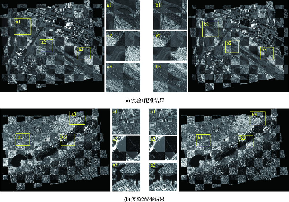
Due to the fact that optical remote sensing image and SAR image have obvious nonlinear intensity differences, and that SAR image has speckle noise, it is difficult to register them. Feature-based image registration and region-based image registration are the two most common methods of optical and SAR image registration. One advantage of feature-based image registration is that it can solve the problem of rotation, scale, and translation differences between images. Another advantage is the small amount of calculation. However, this method usually has the disadvantages of low registration accuracy and instability. Region-based image registration can achieve high-precision registration of heterogeneous images. However, it performs poorly for images with large rotations, scale differences, and it has heavy computation task. For these problem, this paper combines the advantages of feature-based and region-based image registration methods into a hybrid model and proposes an automatic registration algorithm for optical and SAR images. The optical remote sensing image is the reference image while the SAR image is the one to be registered. The SAR-SIFT based on the feature points is used to complete the coarse registration and then the ROEWA-HOG based on the region is used to complete the fine registration. Firstly, the SAR-SIFT algorithm, robust to nonlinear intensity differences and speckle noise, is used to perform feature point detection and feature matching to calculate the affine transformation model of the image to eliminate the obvious rotation, scale and translation difference between the optical image and the SAR image. This is the coarse image registration. Secondly, we use the block Harris corner detection method to obtain a certain number of evenly distributed feature points on the reference image. We determine the search area of the corresponding points on the image to be registered according to the feature points, calculate the ROEWA gradient of the image, and then use a fast calculation strategy to construct the HOG feature vector in the template area with the feature points as the center. Then, we use SSD as the similarity measure to search the corresponding points on the image to be registered. This is the high-precision image registration. Finally, we carry out the image registration and perform visual inspection and quantitative evaluation of the registration results. It is demonstrated that the algorithm in this paper can combine the advantages of feature-based and region-based image registration methods to better resist the noise effect of SAR images and the nonlinear intensity, rotation, scale, and translation differences between optic and SAR images. The final registration accuracy of our high-precision automatic registration method is 1 pixel. High-precision automatic registration for SAR images can meet subsequent comprehensive applications of optical and SAR images.
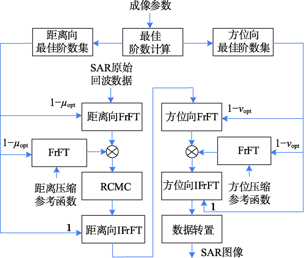
The Traditional Range Doppler (RD) algorithm has become the most classic method in Synthetic Aperture Radar (SAR) image processing because of its advantages of easy implementation and high efficiency. However, its low imaging quality is unable to meet the needs of practical applications nowadays. To resolve this problem, we propose a high-performance imaging procesing algorithm (FrFT-RD) in this paper. The expression of optimal order of SAR range signals using fractional Fourier transform is deduced, and the corresponding formula of the azimuth direction is also given. The theoretical analysis shows that the optimal orders of the range and azimuth direction both depend on the SAR imaging parameters and are unique. Thus, the engineering practicability of FrFT-RD algorithm are large without iteration approaches. The construction of the FrFT-RD algorithm includes: Firstly, the FrFT-RD algorithm based on the traditional range Doppler algorithm is established in the fractional Fourier transform domain using the calculated optimal orders of the range and azimuth direction; Secondly, the fractional Fourier transform of corresponding order is used to process the range signals and the reference function of the range direction to complete the range pulse compression and the range cell migration correction (RCMC). The range signals are reconstructed by the inverse fractional Fourier transform (IFrFT) with the order of 1; Thirdly, the fractional Fourier transform of the corresponding order is used to process the azimuth signals and the reference function of the azimuth direction to complete the azimuth pulse compression. The azimuth signals are finally reconstructed by the inverse fractional Fourier transform (IFrFT) with the order of 1. By comparing results of airborne SAR simulation with spaceborne SAR measurement data, we find that the FrFT-RD algorithm significantly improves the imaging performance on resolution, and peak side lobe ratio (PSLR) compared to traditional RD algorithm. The resolutions of the range and azimuth directions are increased by 45.92% and 48.06%, respectively, and the PSLR and ISLR of the range and direction are decreased by 1.45 dB and 2.59 dB, respectively. While the Frft-RD algorithm almost has the same imaging performance as the traditional RD algorithm in PSLR and ISLR on the azimuth direction.
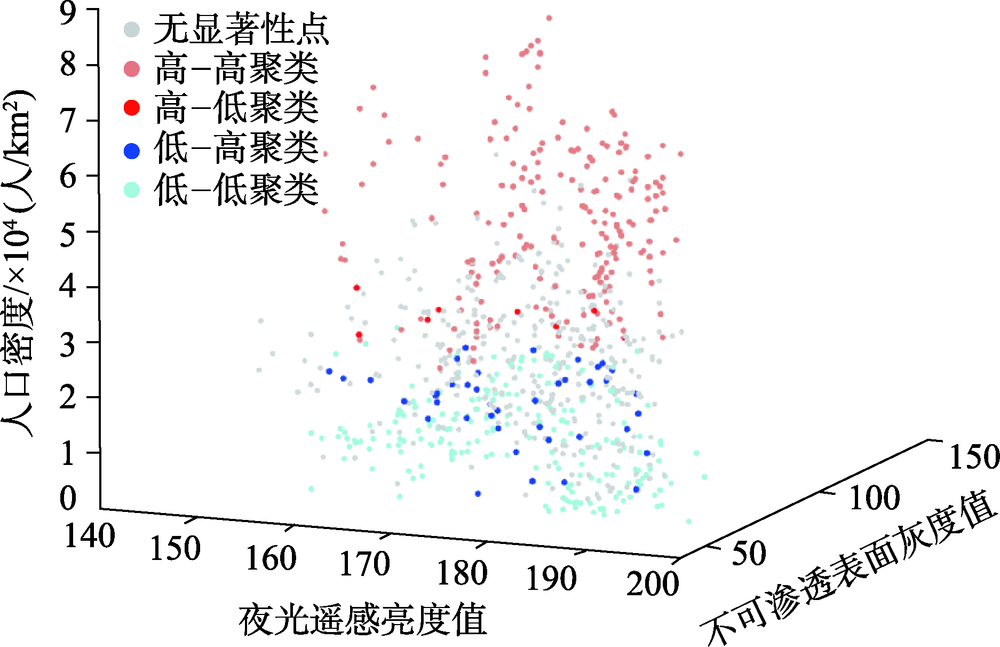
Based on the demographic data, nighttime light remote sensing images and Landsat8 images of streets and communities in Gulou district, Fuzhou city, Fujian province, combined with the kernel density and regression equation are integrated to draw a 30 m spatial resolution population density map and conduct spatial autocorrelation analysis. Firstly, the population density distribution map of 69 communities are calculated by kernel density method. Based on a quantile-quantile plot between the population density and nighttime light remote sensing of 786 residential community points, we find that the population density has a large error in wufeng street and hongshan town. Secondly, the binary quadratic regression equation is established to correct the population density error in these two regions. This equation expresses the relationship between population density, and the impervious surface image of Landsat 8 using linear unmixing and nighttime light remote sensing. Thirdly, Getis-Ord General G, Getis-Ord Gi*, and Anselin local Moran I are used to obtain the high clustering attributes of population in Gulou district to show the largest business circle area, the largest population density residential area in the city, and the local spatial pattern of population clustering. In this study, the population spatialization technique integrates two spatialization methods: kernel density and regression equation. The population density map with 30 m spatial resolution is generated finally. The mean population density of Gulou district is divided into three types: 11 000 people/km2, 25 000 people/km2, and 50000 people/km2. The population density approximately obeys a normal distribution. When the mean population density of Gulou district is greater than 33 000 people/km2, the correlation between the impervious surface gray value and population density is stronger. Otherwise, the correlation between nighttime light remote sensing image and population density is stronger.
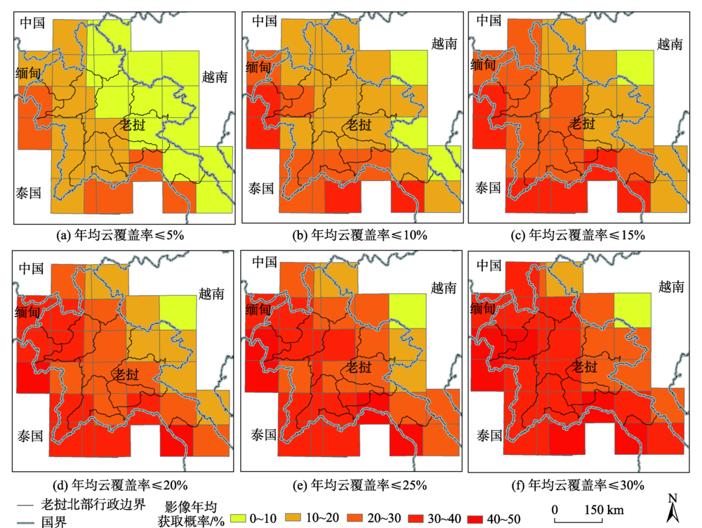
Spatial and temporal characteristics assessment of cloud coverage for optical satellite images is a prerequisite for evaluating its potential as an important remote sensing monitoring data source. Sentinel-2 A/B images have been highly valued in the aspects of land surface vegetation and ecological monitoring at different spatial scales due to their advantages of free access, multi-spectral bands (especially the introduction of red edge bands), and finer spatial (10 m/20 m) and temporal (5-day) resolutions. Compared with Landsat and other similar satellite products, cloud coverage analysis of Sentinel-2 A/B has not been reported. In this paper, the cloud of 5288 Sentinel-2 A/B images (Granule/Tile) over northern Laos from 2016 to 2018 were used to determine the appropriate threshold of cloud coverage for image acquisition probability analysis under different cloud coverage thresholds (0~100%) based on GIS, aiming to reveal the spatial-temporal difference in acquisition probability. The main conclusions are as follows: (1) Sentinel-2 A/B imagery was highly appropriate for land surface remote sensing monitoring with a cloud coverage threshold of 20% (i.e., cloud coverage is ≤ 20%). This threshold resulted in the largest monthly cumulative probability (~27.41%) of Sentinel-2 A/B images in northern Laos. (2) Using the threshold of 20% cloud coverage, the differences in monthly cumulative average acquisition probabilities of Sentinel-2 A/B images in northern Laos were consistent with the temporal distributions of dry season (November to April) and wet season (May to October). The acquisition probability was 42.91% in the dry season, with the largest in March (50.27%), followed by April and February. The fact that Sentinel-2 is featured by larger acquisition probability during the peak of dry season greatly facilitates the monitoring of dynamics in swidden agriculture and rubber plantations. The corresponding probability in the wet season was merely 11.81%, with the lowest in June (~1.26%). (3) Huge differences in monthly cumulative average acquisition probabilities of Sentinel-2 A/B images between the east and west of northern Laos were revealed. In the dry season, the image acquisition probabilities of the western provinces (e.g., Luang Namtha) were much larger than those of the eastern ones, while the situation was just the opposite in the wet season. This study can provide important reference for the large-scale (e.g. global) cloud coverage analysis of Sentinel-2 A/B images and the selection of Sentinel-2 images for monitoring land use change due to United Nations Collaborative Programme on Reducing Emissions from Deforestation and Forest Degradation in Developing Countries (UN-REDD) in the tropics, including swidden agriculture transformation and rubber plantation expansion.