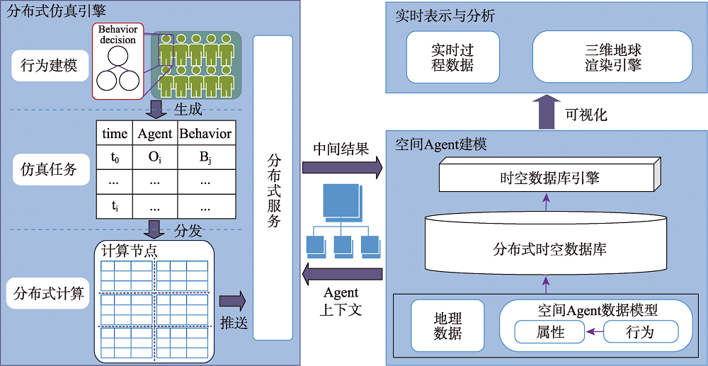
Geospatial simulation based on agent-based modeling is an effective method to recognize and understand dynamic geographic phenomena. As the scale and complexity of geospatial simulation continues to increase, the challenges in model computation increase. Distributed parallel simulation could be used to solve the complex simulation issue of large-scale agents. However, the existing research on building parallel simulation system based on agent modeling/simulation software is not suitable for modeling of spatial agent with high-mobility and behavioral interaction with others, and real-time visualization of simulation process. To solve this problem, this paper proposes a distributed geospatial simulation framework, namely DGSimF, for massive dynamic spatial agent modeling, which supports real-time representation and analysis of the simulation process. A simple but efficient spatial modeling agent for spatial-temporal data is designed, which supports the modeling of integrated geoscience models directly based on agent behavior, adopts the time differentiation method to coordinate the execution of the behavior of each computing node, supports distributed computation in the way of "task parallel" to improve the simulation performance, and constructs a Virtual Geographic Environment (VGE) based on three-dimensional earth rendering engine to support real-time visualization of intermediate simulation results. Finally, the experiments based on the "Red vs. Blue" case are carried out, and the simulation performance with different computation cost and different number of clients is analyzed. The results show that DGSimF can provide an effective platform for massive spatial agent simulation of spatio-temporal feature change and behavior interaction. By expanding the computing nodes, the pressure of complex simulation calculation can be effectively alleviated. Meanwhile, the simulation performance of the proposed framework is high, and the parallel efficiency remains above 0.7 in these experiments.
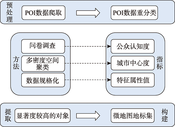
Landmarks play an important role in spatial information transmission, especially for wayfinding navigation. Numerous studies have shown that the inclusion of landmarks in route tasks can effectively reduce steering errors. How to incorporate landmarks into navigation systems and break the barrier of using distance information as the indicator to guide users in wayfinding is currently a difficult problem to solve. And we-map provides a platform for users to produce and disseminate map content. Because we-map does not distinguish between mapmakers and map users, it lowers the threshold for mapping and enables users to have self-make maps. In the process of route mapping, we-map platform can provide a collection of landmarks for users to choose from and use them to complete their wayfinding, enabling the solution to the challenge of incorporating landmarks into navigation systems. In order to extract we-map landmarks accorded with people's spatial cognition, the method of extracting landmarks by user-generated content is proposed. First, there are three indicators (public awareness, city centrality, and individual characteristic value) that are calculated separately, and each of them is obtained by the entropy value method. Then, landmarks are extracted in a hierarchical manner in term of the difference in the significance of landmarks to establish a set of landmarks for serving the users of the we-map. Last, the user-generated landmarks are collected during the process of publishing, sharing, and disseminating the we-map to enrich the landmark library, aiming at realizing secondary dissemination about the extraction of landmarks from user-generated contents. The experiment selects POI data of An Ning District in Lanzhou City to calculate landmark salience, selects landmarks at different levels according to different scales, designs tasks for participants to describe routes and complete connections between landmarks, collects usage landmarks, forms user-generated content to disseminate landmark data, and draws personalized routes that meet different user needs. This study simulates the process of route-finding cartography using landmarks by we-map users to pave the ground for personalized navigation on the we-map platform. The experimental results show that the content generated by using users' shared service data effectively solves the problem of acquiring and timely updating landmark candidate sets, expresses the user's cognitive expressiveness to the greatest extent, and reduces the burden of wayfinding for pedestrians walking out. This study is applied to daily wayfinding, where we-map users participate in constructing and sharing service data, forming spontaneous dissemination of user-generated content, timely update, and dissemination of landmark data, providing reference for rapid we-map drawing, and improving wayfinding efficiency.
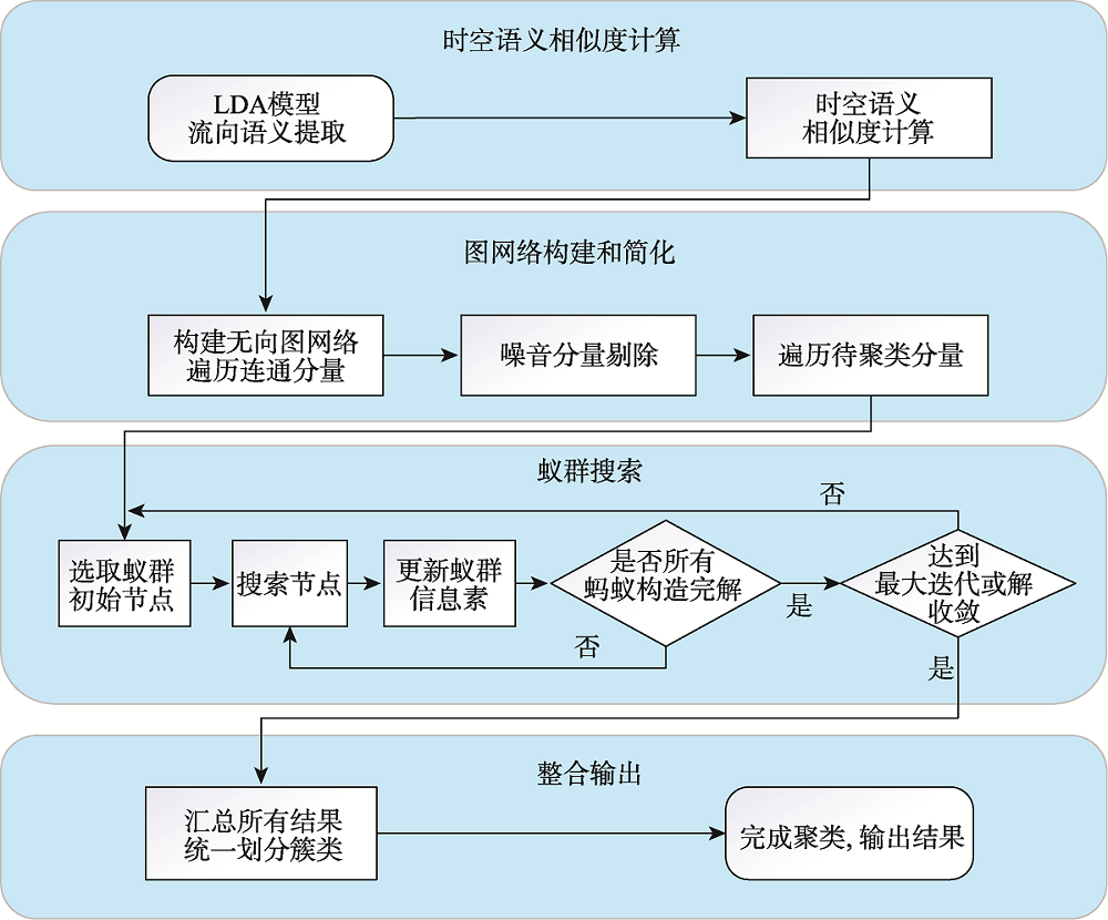
In order to solve the problem that semantic information is not fully considered in existing OD flow clustering algorithms and it is difficult to mine OD flow semantic information, this paper proposes an OD flow clustering algorithm based on the Latent Dirichlet Allocation (LDA) model and ant colony optimization algorithm. Firstly, the LDA Topic model is used to extract OD flows' semantics, and the JS divergence (Jensen-Shannon divergence) is used to quantify the semantic similarity between OD flows. We also propose a spatiotemporal semantic similarity calculation method that is constructed by integrating temporal, spatial, and semantic similarity, which provides data basis for flow clustering. Then, the graph network data structure is constructed according to the spatiotemporal semantic similarity, and the Gaussian function mapping and the connected component of the graph are used to simplify the data and eliminate the noise data. Based on the idea of CFDP algorithm (Clustering by fast search and find of density peaks algorithm), the intermediate centrality of nodes is used to optimize the selection strategy of the initial position of ant colony. Finally, the Multi-path Normalized Cut (MNCUT) graph criterion is used to strengthen the purpose of ant colony search, optimize the clustering effect of ant colony search, and realize the spatiotemporal semantic clustering for OD flow direction. Taking Xiamen taxi open data set and Xiamen map POI data as examples, the proposed method is verified. The experimental results show that: (1) The proposed method can effectively extract the semantic information of flow direction and measure the similarity degree between flow directions more comprehensively compared with the existing methods; (2) The Gaussian function mapping strategy and graph connected component feature are adopted to effectively eliminate the noise in the flow direction data, which saves the computational cost of undirected graph construction effectively by 88.5%~88.8% of the running time; (3) Compared with the existing algorithms, the clustering division of the proposed algorithm is more precise, and the correlation analysis of flow semantics can be carried out conveniently and effectively.
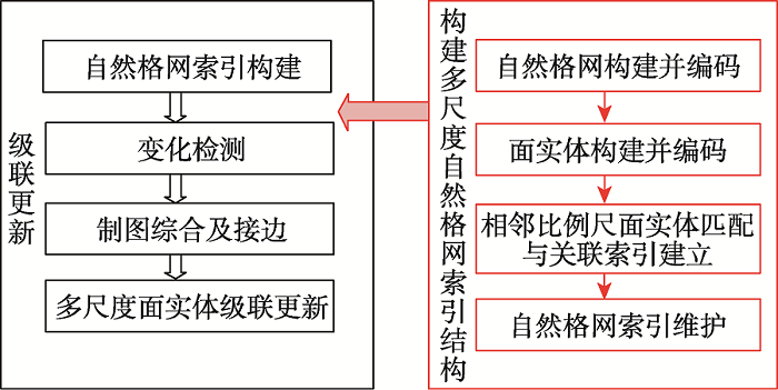
The incremental cascade updating of multi-scale geospatial data is one of the important means to enhance the real time of geospatial data. The incremental cascade updating includes multi-scale data matching, correlation relationship establishment, matching and change detection, incremental information generalization, and incremental cascade update. The adjacent scale data matching is the basic of multi-scale data correlation establishment and an important foundation for the implementation of incremental cascade update. Aiming at the low accuracy and efficiency of association matching between multi-scale entities with the same name in existing methods, an incremental cascade updating method of multi-scale surface entities based on natural grid index is proposed. By building the natural grid and coding, building the surface entity and assigning code, adjacent scale entity matching and associated relationship, the corresponding steps of the correlation relationship are established, and the natural grid index is introduced into the incremental cascade update. The specific steps include: firstly, incremental packets of the same source and same scale vector spatial data are detected; secondly, the grid location of the updating entity is determined by the natural grid index, and then deleted and updated automatically or manually; and finally, the cartographic generalization and edge joining are implemented. Taking the residential elements in Hushan villiage of Ganzhou City as an example, the experimental results show that: 1) when the matching threshold is set to 0.51, compared to the direct matching method, the time consumed by the natural grid index method proposed in this paper is reduced by 88.4%, and the recall and precision are increased by 5% and 4%, respectively, which demonstrates the effectiveness of the natural grid index method in matching geographical elements between adjacent scales; 2) compared with the traditional Hausdorff distance, Euclidean distance, and centroid methods, the method proposed in this paper performs best with low time cost (1.34s), and high recall (66.5%) and precision rates (94.1%), which demonstrates the effectiveness and efficiency of the cascade update method proposed in this paper; 3) the proposed method can avoid the influence of the difference of associated residential areas, thus greatly reducing the operation time of manual editing, and effectively improving the accuracy and efficiency of multi-scale incremental cascade updating of residential entities.
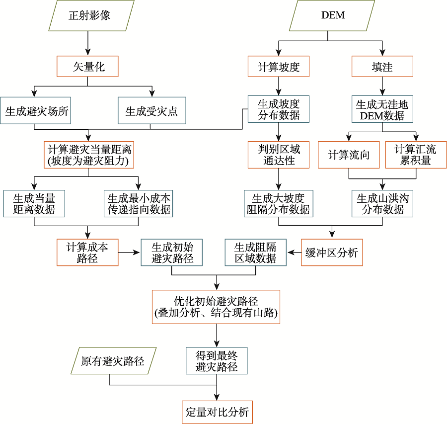
The ability of disaster prevention and mitigation in mountainous and rural areas is weak. Mountain flood disasters have strong suddenness, and the response time of disaster avoidance is short, which are likely to cause casualties. Reasonable design of avoidance routes can help reduce losses caused by disasters. Based on GIS, this paper designs disaster avoidance routes in Tianbaizhi Village, Xingtai City, in the Hebei Province. The Digital Elevation Model (DEM) and orthophoto of the research area are obtained through Unmanned Aerial Vehicle (UAV) photogrammetry. Factors that influence disaster avoidance route planning including slope, cost distance, and function of cost path are used to calculate the initial avoidance route in the mountainous areas. The area where the mountain flood ditch is located and the area with a large slope are used as the interrupted area of the disaster avoidance route. The existing mountain roads are fully considered and rationally used to optimize the final disaster avoidance route. Based on the distance and average slope of the disaster avoidance route, the disaster avoidance route obtained by this method is quantitatively compared with the original disaster avoidance route. The result shows that (1) Among the 20 long-distance disaster avoidance routes designed, this method shortens the length of 18 routes, reduces the average slope of 10 routes, and controls the increase of the average slope of the other 8 routes within 2°; (2) Compared with the original route, the maximum length of each route can be shortened by 329.74 m, and the average slope only increases by 0.68°. The disaster avoidance distance is shortened by adding a small amount of average slope, which improves the disaster avoidance efficiency; (3) The length of remaining two routes increases by 15.21 m and 9.57 m, respectively, resulting in an average slope reduction of 8.43° and 1.43°. The average slope of the routes is reduced by adding a small amount of distance, which improves the safety of disaster avoidance routes; (4) The southern part of Tianbaizhi Village is close to the disaster avoidance point, and the avoidance of disasters is relatively difficult. In contrast, the northern part of Tianbaizhi Village has a longer route to the disaster avoidance point. The longest distance is 1210.02 m, and the difficulty of disaster avoidance is greater. The optimized disaster avoidance path has been separated from the barrier area with large slope, and the degree of overlap between disaster avoidance path and the mountain flood ditch is greatly reduced. The method proposed in this study provides a sufficient scientific basis for relevant decision-makers.
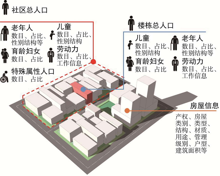
The current population situation in China is facing the risks of aging and declining birthrates. Paying attention to "the elderly and children" and ensuring that the elderly are supported and children are raised has become a special concern in Chinese urban and rural development. In this context, how to create a social environment conducive to old-age care and childbirth has become an important topic of social construction, and the allocation of facilities for vulnerable groups such as children, women of childbearing age, and the elderly has also become an important part of the people's livelihood project. As the spatial carrier of urban public services, improving the allocation mode of community service facilities is an important way to implement the people-oriented concept and embody social equity. At present, the travel time cost matrix obtained from the network map planning path API can provide near-real travel time data for accessibility research. In addition, individualized population data, such as the actual population data, can provide a basis for identifying various vulnerable groups with its rich attribute information and accurately describe the spatial distribution of the population. Considering the demand and characteristics of vulnerable people and relevant legal regulations, this paper puts forward a clear definition of three vulnerable groups: children, women of childbearing age, and the elderly, and constructs the supply standard of community service facilities which is oriented to the individual demand of these three vulnerable groups. On this basis, using the actual population data, the travel time cost matrix from network map, and data points of interest and comprehensively considering the capacity of community service facilities, the paper proposes a method to evaluate the community service facility supply and layout optimization by individual evaluation of the accessibility of vulnerable people. We take the Renminnan South Community in Guangzhou as an example to verify our method. The result shows that the supply of service facilities for vulnerable people in Renminnan community is insufficient. After the optimized configuration, the supply and demand situation of the facilities become more reasonable, and the coverage of service is also significantly improved. The method proposed in this paper can accurately evaluate the rationality of the layout of current community service facilities for vulnerable people from individual scale, thereby providing new ideas for detailed study of spatial distribution of community service facilities under the current population situation.
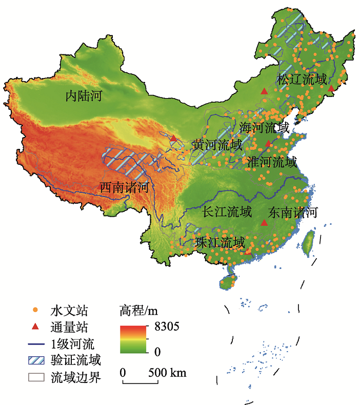
Evapotranspiration (ET) is the link of water exchange between land surface and atmosphere, and has an important effect on the water cycle and energy cycle. In the context of climate change and increasing anthropogenic activities, significant changes in ET have been detected over past decades, which has profoundly impacted the global water cycle system and climate system. Thus, accurate estimation of spatiotemporal variability of ET and its components under a changing environment is essential for water resources planning and management. In this paper, we used the GLEAM-ET dataset to investigate the spatial-temporal dynamics of ET and its components in nine river basins of China. The applicability of the GLEAM model is verified at multiple scales in China based on ET observations at 7 flux sites, ET_water based on water balance principle in 120 basins and the PML_V2 evapotranspiration product. The spatial and temporal patterns of ET and its components (i.e., vegetation transpiration Ec, retained evapotranspiration Ei, and soil evapotranspiration Es) are comprehensively analyzed in the context of revegetation. The results show that: (1) The GLEAM-ET product has a good applicability in nine major river basins in China, and its performance is related to the climate zone. The applicability in arid areas is better than that in humid areas. In addition, the GLEAM and PML_V2 models have a good correlation in nine major watersheds (R>0.7), and their distribution pattern and change trend are consistent overall; (2) From 1980 to 2020, the average ET of China is 416.88 mm, and the growth rate is 1.21 mm/yr. Both Ec and ET show a decreasing pattern from southeast to northwest, while Es shows a reverse trend. The Ec and ET show a significant increasing trend in the 9 major watersheds (p<0.001). The Ei and Es show a significant increase and decrease in the monsoon watersheds, respectively, and an insignificant decrease (p>0.05) and a significant increase trend in inland watersheds, respectively; (3) The proportion of each ET component obviously changes under the background of vegetation restoration. The change of Ec proportion is different from north to south. The Ec proportion decreases in the southern basin and increases in the northern basin. The proportion of Ei and Es increases and decreases, respectively, over all basins. The ET components in the Yellow River Basin respond most obviously to vegetation restoration, with Ec increasing by 5.21% and Es decreasing by 5.56%. These findings will help to provide guidance for water resource management and planning the formulation of ecological restoration policies on the Loess Plateau.
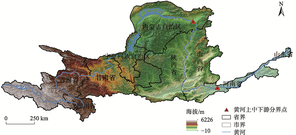
Healthy human capital plays an important role in promoting social and economic development. Taking 71 prefecture-level administrative units in the Yellow River Basin as the research area, using methods such as coefficient of variation, Theil index, and spatial autocorrelation model, the temporal and spatial evolution characteristics of population life expectancy in the basin are studied, and the influencing factors are analyzed based on geographic detectors. The results show as followed: (1) From 2000 to 2019, the average life expectancy of the population increased from 69.99 years to 76.96 years, showing an overall upward trend, but it has long been lower than the average life expectancy of our country's population; (2) The overall regional differences in life expectancy of the population in the Yellow River Basin shows a trend of increasing first and then decreasing, and the differences between the zones continue to converge. The differences within the zones are basically consistent with the overall changes in the basin; (3) There is obvious spatial agglomeration in the life expectancy of the population, but the spatial autocorrelation decreases and has large spatial variation. Specifically, the Huangnan Tibetan Autonomous Prefecture, Hainan Tibetan Autonomous Prefecture, Gannan Tibetan Autonomous Prefecture, and other Tibetan areas have formed stable cold spots, and the scale of Shandong Province forms a stability hot spot; (4) Medical and health resources and natural conditions have the most significant impact on the life expectancy of the population in the upper reaches; the level of economic development and environmental pollution have the strongest explanatory power for the life expectancy of the population in the lower reaches; the level of education is an important factor affecting the life expectancy of the population in all regions of the Yellow River Basin. The explanatory power of the interaction of different factors is higher than the explanatory power of a single factor. The spatial difference in the life expectancy of the population in the Yellow River Basin is the result of multiple factors.
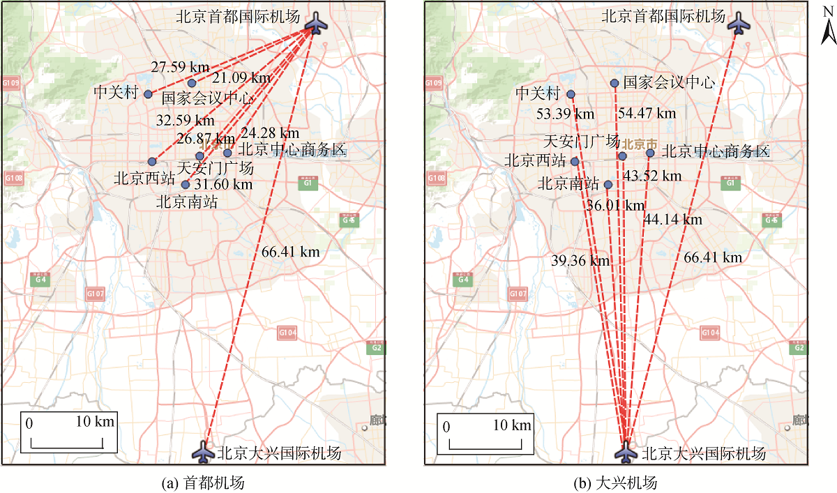
For a city with dual hub airports, the relationship between two airports is important for its integrated transport system. Since 2019 Beijing has been a city with dual hub airports, namely Beijing Capital International Airport (PEK, hereinafter referred as “Capital Airport”) and Beijing Daxing International Airport (PKX, hereinafter referred as “Daxing Airport”). Based on the Gaode Map API, which can obtain real-time data precisely, this paper obtains real-travel-time data in both auto mode and public transport mode. It investigates the accessibility spatial pattern of two airports under the two travel modes from the perspective of residential travel so that we can offer suggestions on the integration development of “civil aviation-urban transportation” system. The results show that: ① The use of Daxing Airport has effectively improved the spatial accessibility to airports in Beijing, especially from the south area, making civil aviation service in Beijing tend to be a “north-south equilibrium”. The coverage of the two airports is complementary in 0.5-hour service area by driving and 1 hour service area by public transport, which effectively improves the efficiency of aviation service in Beijing. ② In Beijing, accessibility by auto is higher than that by public transport and accessibility from Capital Airport is higher than Daxing Airport in both travel modes. Under the auto mode, the two airports begin to compete in the coverage within 1 hour journeys. For public transport mode, there is competition within 1.5 hour. ③ Under the public transport mode, the service area and population of the two airports in Beijing need to be improved, as the two airports only serve 1.4% of urban area and 7% of total population in Beijing. So it is important to construct 1 hour service area for residents to access the airports. ④ In the view of intra-urban transfer, accessibility from train stations to the Capital Airport is higher than that of Daxing Airport. Hence, accessibility between Daxing Airport and train stations should be enhanced to support the integration of aviation and high-speed rail travel. Last, we offer suggestions in order to promote the effective integration of airport and urban traffic system in double hub airport cities.
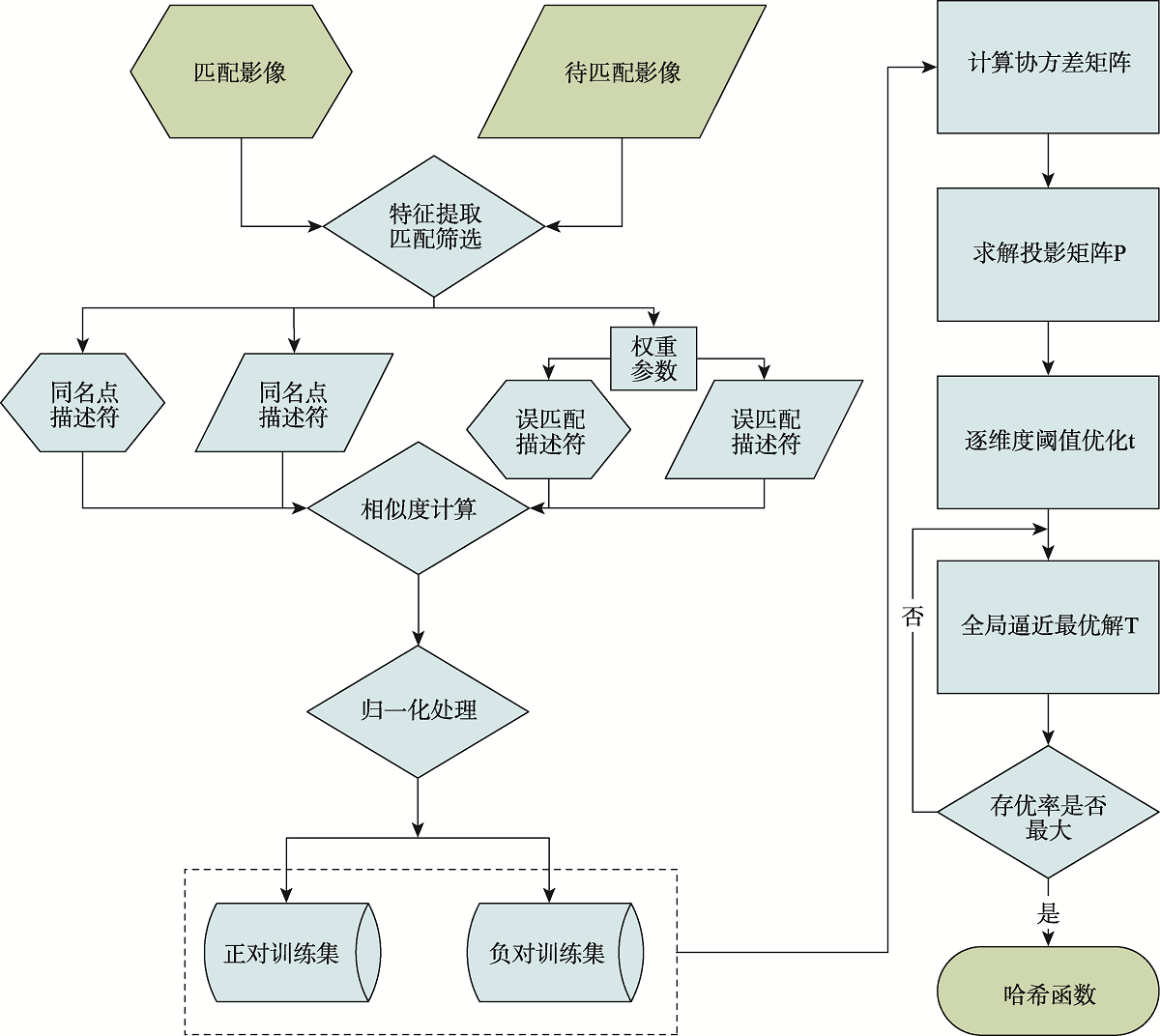
To solve the existing problem that traditional matching methods are difficult to achieve fast matching on the spaceborne platform under the condition of limited storage and computing power. So, this paper proposes a fast image matching algorithm based on spaceborne platform. The feature descriptors of the same-origin satellite images are used as the training set to calculate the hash function, and the floating-point feature descriptors are mapped to the Hamming space to calculate the similarity. The mismatching elimination method is used to get a set of matching points with higher matching accuracy. And the types of feature descriptors can be flexibly adjusted according to the sensor type of the spaceborne platform load, image resolution, and landform type of the target area image, which makes the proposed method have good reconfigurability. The hamming distance is calculated to measure the similarity between feature point pairs and improve the application ability of the method in the light-weight processing of the spaceborne platform. The matching experiments of different geomorphological features using the different orbital imageries from ZY-3 and GF-7 satellites are completed. The experiments prove that compared with the SIFT, the LW-SIFT (Light Weight Scale-Invariant Feature Transform) proposed in the paper can achieve satellite remote sensing image matching more efficiently, reducing time consumption by 50.12% and increasing the number of correct matching points by 20.28 %. This proposed method can significantly improve the accuracy and timeliness of matching and has a large application potential for spaceborne platform applications.
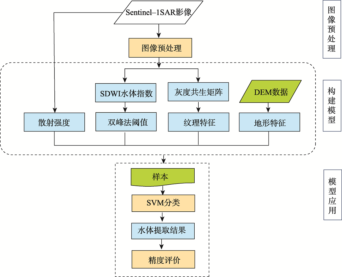
In cloudy and rainy regions with complex surface environments, water body extraction based on Synthesis Aperture Radar (SAR) image is easily interfered by other surface features such as paddy field and mountain shadow. The traditional gray threshold method and SVM method fail to take into account the differences in texture and terrain information between water and other surface features, resulting in the low accuracy of water body extraction. In this paper, we first use refined Lee filter to pre-process the SAR image, then extract terrain features by modeling DEM and calculating the slope information. We extract the texture features, including the homogeneity (hom), Angular Second Moment (ASM), and entropy (ENT), by calculating image Gray Level Co-occurrence Matrix (GLCM) based on the SAR image. Meanwhile, polarization band information of the SAR image and SDWI index are combined to form the SVM feature space for water body extraction. Finally, an improved SVM classification method for water body extraction is proposed by fusing terrain features with image texture features. Compared with SDWI water index method and traditional SVM method based on Sentinel-1 SAR data, it is found that the improved SVM method can remove the shadows of paddy field and mountain. The result of water surface extraction by the improved SVM method is more complete than that of traditional SVM method. The result also shows that the improved SVM method performs better than SDWI method and traditional SVM method in terms of overall accuracy, kappa coefficient, leakage rate, and error rate. The overall accuracy of the improved SVM method is 98.06%, which is 23.24% and 5.49% higher than that of SDWI method and traditional SVM method, respectively, demonstrating that the improved SVM method can effectively improve the extraction accuracy of surface water in complex environments. The developed method is applied to monthly water extraction and change analysis of Mahaweli River Basin in 2018, which proves that the method can effectively solve the problems of mountain shadow and paddy field misclassification. The improved SVM method can realize the accurate and complete large-scale water body information extraction in complex surface environments.
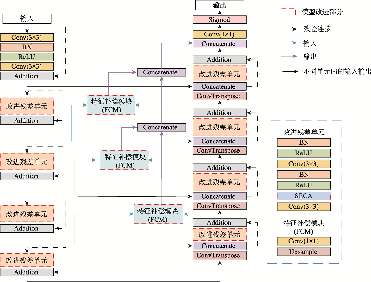
Aiming at the problem that the background of high-resolution remote sensing images is complex and road extraction is easily disturbed by background information such as shadows, buildings, and railroads, the DAFCResUnet model with lightweight dual attention and feature compensation mechanism is proposed in this study. The model is based on ResUnet and achieves a balance between model performance and spatiotemporal complexity by adding lightweight dual attention and feature compensation modules. The dual attention module enhances the feature extraction capability of the model, and the feature compensation module can fuse the road features from deep and shallow layers in the network. The experimental results using DeepGlobe and GF-2 road datasets show that the IoU of the DAFCResUnet model can reach 0.6713, 0.8033, respectively, and the F1-score is 0.7402, 0.8507, respectively. The overall accuracy of the model is higher than that of U-Net, ResUnet, and VNet models. Compared with the U-Net and ResUnet models, the DAFCResUnet model only increases a small amount of computation and number of parameters, but the IoU and F1-score are improved substantially. Compared with the VNet model, the DAFCResUnet model achieves a higher accuracy with much lower computation and smaller number of parameters, and the model has advantages in both accuracy and spatiotemporal complexity. Compared with the other models, the DAFCResUnet model has stronger feature extraction and anti-interference ability, which can better solve the commission and omission caused by interfering objects on the road, ground features similar to roads, tree shade or shadow shading, etc.
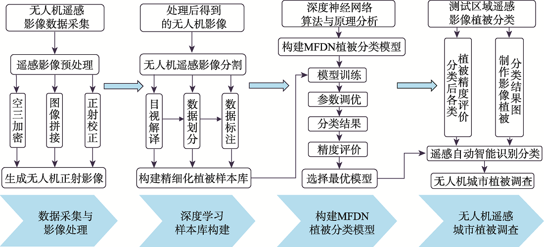
At present, the classification of urban vegetation is affected by similar characteristics and similar spectra, resulting in misclassification of vegetation. Therefore, a Multi-scale Feature Perception Network (MFDN) combined with high-resolution UAV visible light images is designed to classify urban vegetation. This network addresses the problem of misclassification and reduces the loss of spatial information by introducing coordinate convolution in the input layer. It constructs parallel networks to enhance multi-scale feature information and introduces repeated multi-scale fusion modules between networks to maintain high-resolution representation in the entire process and reduce the loss of detailed features. In addition, the separation feature module is added to expand the receptive field and obtain multi-scale features, thereby effectively alleviating the phenomenon of misclassification and omission of urban vegetation. The results show that the MFDN method improves the classification of urban vegetation mainly through spatial patterns rather than spectral information from UAV visible light images. The average overall accuracy is 89.54%, the average F1 score is 75.85%, and the average IOU is 65.45%. The segmentation results are accurate and complete. Therefore, the proposed method is compatible with the easy-to-operate low-cost UAV system, is suitable for rapid survey of urban vegetation, and can provide technical support and scientific basis for urban space utilization and ecological resource survey.
As China's urbanization process accelerates, urban heat island is difficult to alleviate. There have been many studies on the impact of land use/cover type, city size, and urban morphology on urban heat islands. There is still a lack of research on the impact of climate background on the intensity of diurnal Surface Urban Heat Islands (SUHII) in China. To explore the temporal and spatial distribution characteristics of diurnal SUHII in different climatic regions in China, this study firstly uses the GEE cloud platform to obtain the annual and seasonal average surface temperature data of each city and the area of urban and suburban, and then calculates the SUHII of each city. The Sen's slope method and M-K non-parametric trend test method are used to calculate the temporal change trend of diurnal SUHII in China. Finally, this study discussed the spatial distribution and temporal changes of SUHII from the spatial and temporal scales. The results show that: (1) Diurnal differences: the annual average SUHII of cities in China at daytime (1.25±0.81 ℃) is higher than that at nighttime (0.79±0.43 ℃); (2) Seasonal differences: the diurnal SUHII has different results in different seasons. The daytime SUHII is high in summer and weak in winter. There are little differences between the four seasons at night; (3) Differences in climatic regions: the distribution of diurnal SUHII shows obvious spatial differentiation. The daytime SUHII in the tropics and subtropics is higher than that in temperate and plateau climate regions, with the strongest SUHII occurring in the southern subtropics and the weakest SUHII occurring in plateau climate regions. The nighttime SUHII is higher in the temperate regions than in tropical, subtropical, and plateau climate regions, with the strongest occurring in the mid-temperate regions and the weakest occurring in the northern subtropics; (4) Temporal and spatial changes: The daytime SUHII shows a non-significant downward trend (|Z|<1.96), while nighttime SUHII shows a significant upward trend (|Z|>1.96). There are seasonal differences in the inter-annual variation of diurnal SUHII. In the daytime, the upward trend of SHUII in summer are significantly higher than that in other seasons, and nighttime SHUII shows a significant upward trend in all seasons, of which SUHII has the largest upward trend in winter. Cities with a significant upward trend in the daytime are mainly distributed in the tropics and southern subtropics, and cities with a significant upward trend at night are widely distributed in the mid-temperate and warm-temperate regions.
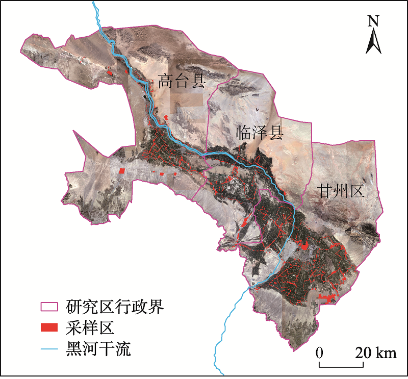
Obtaining the condition of crops in the early growing season is important for the agricultural water resources management, especially for water allocation in water shortage areas. In this paper, the Enhanced Spatiotemporal Adaptive Fusion Model (ESTARFM) was used to fuse Sentinel-2 NDVI data with NDVI data calculated from MOD09GQ in the early growing season in the middle reaches of the Heihe River basin from March to June to construct NDVI time series, and then the random forest classification method was used to identify the crop structure in 2019. By using the Sentinel-2 NDVI time series and spatiotemporal fused NDVI time series jointly in the early growing season (i.e., from March to June), the crop classification accuracy reached 91.42 % with a kappa coefficient of 0.85. Compared with the classification results obtained using only Sentinel-2 NDVI time series, the accuracy improved by 1.01 % and the kappa coefficient improved by 0.02. The accuracy was only 1.53 % lower and the kappa coefficient was only 0.03 lower than the results obtained using Sentinel-2 NDVI time series in the whole crop growth period (from March to October). The Gini coefficient was used to evaluate the feature importance of the time series constructed by combining the Sentinel-2 NDVI time series and fused NDVI series. It was found that six of the 10 NDVI images with Gini coefficient scores higher than the average were spatiotemporally fused images, indicating that the NDVI data obtained by spatiotemporal fusion could improve the classification accuracy. The NDVI time series of different lengths were also established separately for early identification of crop structures. Results show that early identification of alfalfa and corn can be achieved as early as mid-April and late April, respectively. In addition, the classification accuracy of corn was strongly influenced by the length of NDVI time series, and early identification of corn can be achieved in late May.
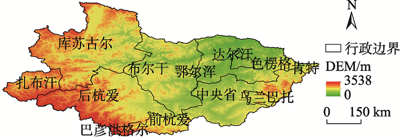
Arid and semi-arid climate zones of the Mongolian Plateau support multiple river systems that significantly impact the distribution of resources and ecological environments of the region. The Selenga River is the most important water resource on the Mongolian Plateau and the only river that enters the largest freshwater lake in the world——Lake Baikal in Russia. Thus, an accurate understanding of the hydrologic characteristics of the Selenga River Basin is critical in monitoring the ecology, environment, and water resources in Northeast Asia. Obtaining the plane morphology of curved rivers in the upper reaches of the plateau region is helpful to analyze the mathematical and physical mechanism of the evolution of curved rivers, which is of great significance to the study of river geomorphology. In this study, the Selenga River Basin in the Mongolia was taken as the study area. Based on the Google Earth Engine (GEE) cloud platform, Sentinel-2 multi-spectral satellite remote sensing images, Normalized Difference Water Index (NDWI), Modified Normalized Difference Water Index (MNDWI), and automated Water Extraction Index (AWEI) were used to construct a deep neural network model for the extraction of fine water body data in the Selenga River Basin. Three different types of water bodies, including lakes, main streams, and tributaries, were selected to compare the extraction results of deep neural network with the extraction results of support vector machines and Global Surface Water data. Global 30 m SRTM data were then used to generate a river system vector distribution map, identify river extraction target areas, and draw a 10 m spatial resolution river distribution map for the 2019 Selenga River Basin using output from the deep neural network model. Results indicate that, firstly, this method can accurately produce a water regime map for a large basin. The extraction results can reflect the spatial distribution of rivers in the Selenga River Basin in Mongolia, as well as reduce the drying-up and empty phenomenon of rivers. Secondly, the batch size of eight in the deep neural network model optimize data processing speed and accuracy while the four hidden layers in the neural network structure produce an accuracy evaluation index of 0.9666, which guarantees feature mining capabilities of models. Thirdly, after the verification of sample points, the overall accuracy reaches 97.65%, meeting actual application requirements. Thus, this research provides a method and data support for water body extraction for the Mongolian Plateau, which will play an important role in revealing long-term changes in river hydrological conditions, and impact related research on resources and environmental benefits.