1 引言
山洪灾害已成为中国高频发和高死亡率的自然灾害之一,严重威胁了国民生命财产安全和水安全,是中国防汛减灾工作的重点和难点问题[1 -3 ] 。短历时强降雨是诱发山洪灾害的直接因素和激发条件[4 ] ,溪沟、河川水情变化是山洪过程的直观反映,及时准确地监测降雨和径流情势变化是预测山洪暴发的基础和前提[5 -6 ] 。地面监测站网是获取区域尤其是地形复杂的中小流域暴雨、水文特性的重要途径之一,水雨情站网的合理布设及优化有利于捕获降雨量及强度变化、洪水情势变化的时空异质性[7 ] ,减少流域水文模拟的不确定性,显著提高中小流域洪水预报、山洪灾害预警的精度[8 ] 。中国自1956年开展了第一次全国站网规划,并逐年进行了优化调整。截止到2009年,中国雨量站和水位站平均密度约为500 km2 /站和5600 km2 /站,基本达到世界气象组织推荐的容许最稀站网密度[9 ] ,但对于山洪灾害频繁发生的山丘区中小流域的站网密度要求仍难以满足,严重制约了山洪灾害预警预报能力[10 ] 。2006年国务院正式批复了《全国山洪灾害防治规划》,要求加强水雨情监测等非工程措施建设,提升山洪灾害监测预警和防御能力。自2010年起,中国已初步建立了覆盖山洪灾害防治区的监测预警网络[6 ,11 ] ,但仍需结合区域山洪特点和规律、山洪灾害预警需求等,进一步完善优化水雨情监测站网,提升县级、省级和国家级防灾减灾能力,为山丘区人民生命财产提供安全保障。
近年来,国内外许多学者对水雨情站网布设方法开展了广泛的研究[12 -13 ] 。国外常用的方法包括统计分析法、空间插值技术、熵理论、用户调查法以及综合法等[14 ] 。统计分析法包括方差缩减技术[15 -16 ] 、主成分分析法[17 -18 ] 、回归分析法[19 -20 ] 、广义最小二乘法[21 ] 等,常用于水文气象条件均质的流域;空间插值技术依赖已建测站的长序列历史资料进行站网优化或布设[22 -23 ] ;熵理论认为雨量站应布设在信息传递值较小的地区[24 -26 ] 。上述方法多用于已设站网稠密地区的优化问题。中国学者于20世纪50、60年代提出了积差法、暴雨中心控制面积法、锥体法等基本雨量站网布设方法[13 ,27 ] ,但前2种方法由于存在理论缺陷和布站间距要求较小等问题,已较少应用[28 ] ;锥体法由于方法简便、资料要求低,目前已被广泛用于中国站网稀疏的中小流域站网布设及规划[29 -31 ] 。20世纪80年代以来提出的抽站法和流域水文模型法等对站网密度和监测序列长度要求较高,常用于检验其他方法的合理性[5 ,32 -34 ] 。1981年原水利电力部水文局采用江西省雨量站网试验区高密度的雨量站点构建了经验公式,用于梅雨型中小河流配套雨量站网布设[35 -37 ] 。王美荣等[38 ] 基于流域数字水文模型探究了水阳江流域29个雨量站布设的合理性。李春红等[39 ] 采用相关分析、雨量等值线、抽站法、站网与预报模型匹配法论证了新丰江流域的雨量站网布设。虽然近年来水雨情站网布设方法已较为成熟并得到了广泛的应用,但考虑 山洪灾害防治的站网布设定量化方法研究相对较少[5 ,40 -41 ] 。因此,本文以山洪灾害高发的福建省顺昌县为例,提出了面向山洪预警的水雨情站网布设方法,综合分析流域降雨时空特征、历史山洪灾害与山洪灾害预警预报需求,对水雨情站网进行了合理性分析,并给出优化布设方案。
2 研究区概况
顺昌县位于福建省西北部(117°30′~118°14′ E,26°39′~27°12′ N),全县总面积为1985 km2 ,其中山区面积为1618 km2 ,占总面积的81.5%。县域属亚热带湿润性季风气候,多年平均降雨量和径流深分别为1756 mm和870 mm,其中汛期(4-10月)降雨量约占全年总量的78%。县内洪水主要由锋面雨和台风雨形成。富屯溪和金溪为县内主干流,属于闽江水系,境内山区性小溪流众多,短历时、强暴雨极易导致洪水峰高流急,极易暴发山洪灾害。顺昌县已建雨量站28座、水位站26座,其中水库水位站14座,水位站同时监测降雨过程。已建雨量站网监测密度约为37 km2 /站,水位站网监测密度约为76 km2 /站。流域内下垫面空间分布较为均匀,主要的土地利用类型为有林地(79%)和耕地(13%),主要的土壤类型为红壤(80%)和水稻土(16%)。顺昌县地形及水雨情监测站网布设情况如图1 所示。
图1 研究区概况图
Fig. 1 Map of the study area
顺昌县是福建省山洪灾害的频发地区,全县共有12个乡、132个村位于山洪灾害危险区,约38%的人口受到山洪灾害威胁。据历史山洪灾害数据显示:截至2010年,顺昌县共发生了31次大型山洪灾害,其中2010年6月顺昌县各流域山洪全面暴发,多条溪沟发生有记录以来最大洪水,因灾死亡、失踪14人,直接经济损失约10亿元人民币。
3 研究方法
3.1 雨量站网布设方法
雨量站网布设涉及雨量站总数及其空间分布分析和优化。采用锥体法分析满足流域山洪灾害预警分析要求的雨量站总数;采用相关系数法和考虑山洪预警的站网布设方法对雨量站的空间分布进行优化,前者侧重降雨过程的时空分布特征,后者侧重历史山洪灾害情况及山洪灾害预警预报 需求。
3.1.1 锥体法
锥体法认为场次暴雨量从暴雨中心向边缘逐渐减少,以暴雨等值线梯度变化最大的一边作为圆锥体的一边,以通过暴雨中心的垂线为轴线[27 ] 。假设从暴雨中心至边缘的降雨量呈直线变化,可将降雨总量概化为圆锥体和圆柱体的组合,降雨总量计算如下:
w = 1 3 π L n 2 ( p 0 - p n ) + π L n 2 p n = 1 3 π L n 2 ( p 0 + 2 p n )
式中:p 0 为暴雨中心雨量;pn 为计算面积边缘雨量;Ln 为计算面雨量的面积半径。
若雨量站网按正方形网格点布设,暴雨中心处于4个雨量站所形成的网格中心,即正方形对角线交点,依据三角函数可得漏测暴雨中心的水量为:
v = 1 3 π ( 1 2 Δl ) 2 ( p 0 - p i ) = 1 6 πΔ l 2 ( p 0 - p i )
式中:Δl 为雨量站间距;pi 为暴雨中心附近网格点雨量站雨量。
降雨总量相对误差为:
ρ = v w = Δ l 2 ( p 0 - p i ) 2 L n 2 ( p 0 + 2 p n )
如果推求面雨量允许的相对误差为e ,则:
Δl = 2 e L n 2 ( p 0 + 2 p n ) ( p 0 - p i )
流域内应设雨量站数量为:
N = A Δ l 2
式中:A 为流域面积;N 为布设雨量站个数。
3.1.2 相关系数法
降雨量与其所处的地理位置、地形、地貌等条件密切相关,相邻站点降雨量存在相关性,当邻近雨量站的降雨特性较为相近,表现为其降雨量相关系数较大,可考虑进行站点合并,当邻近站的降雨量相关系数较小,需在相邻雨量站间增设雨量站。相邻雨量站的降雨量相关系数计算如下:
R ij = ∑ k = 1 m ( X ik - X ̅ i ) ( X jk - X ̅ j ) ] ∑ k = 1 m ( X ik - X ̅ i ) 2 ∑ k = 1 m ( X jk - X ̅ j ) 2
式中:i 和j 分别表示第i 和j 个雨量站(i =1, 2, …, n ;j =1, 2, …, n ; i ≠j );n 为流域内雨量站个数;Rij 为第i 和j 个雨量站的降雨量相关系数;Xik 和Xjk 分别为第i 和j 个雨量站的第k 个降雨量值(k =1, 2, …, m );m 为降雨量序列长; X ̅ i X ̅ j i 和j 个雨量站的降雨量平均值。
3.1.3 考虑山洪预警的站网布设
为满足山洪灾害预警预报的需求,需进一步结合县内历史山洪灾害情况、人口分布、社会经济状况等实际情况,对雨量站网分布进行布设研究。站网布设原则如下[42 -44 ] :
(1)雨量站布设需满足分区控制、流域控制、地形控制等原则;
(2)雨量站应分布均匀,以便掌控区域降雨时空变化规律,满足面雨量计算和有关水情业务系统的需求;
(3)山洪易发区内的主暴雨区及地质灾害多发区的雨量站网布设密度应达到20~30 km2 /站,次 暴雨区及地质灾害区雨量站网布设密度应达到 50~100 km2 /站,一般暴雨区雨量站网布设密度应达到100~200 km2 /站;
(4)山洪灾害重点防治区范围内人口分布较为稠密或分布有重要工况的村庄、流域,应加密雨量站网布设,保障山洪灾害预警预报的需要,减少山洪暴发造成的社会经济损失;
(5)站网布设应充分考虑通信、交通等运行管理维护条件。
3.2 水位站网布设方法
水位预警直观可靠,且适用于水库、堤防等水利工程以及雪山融水、地下河等特殊条件。水位站的合理布设对溪沟洪水预警至关重要。水位站的布设应考虑山洪灾害发生的频度、影响程度、影响范围、人口社会经济等实际情况因地制宜确定。站网布设原则如下[42 -44 ] :
(1)山洪灾害重点防治区范围内人口分布较为稠密或分布有重要工况的村庄、流域,应在其上游布设水位监测站,并预留至少30 min的洪水预警 时间;
(2)对于无水位监测设施的水库(尤其是重要的小I型水库)、山塘等水利设施,其下游人口分布较为密集时,应在坝前布设水位监测站,并预留至少30 min的洪水预警时间;
(3)水位站网布设应符合容许最稀站网原则和《水文站网规划技术导则》(SL34-92),并考虑通信、交通等运行管理维护条件;
(4)水位站网布设应满足山洪灾害预警预报需求,以进一步提高小流域暴雨洪水预报精度。
4 结果与分析
4.1 雨量站网布设及评价
(1)锥体法分析
顺昌县按水系可分为富屯溪(干流)流域、仁寿溪流域、路兹溪流域、高阳河流域等4个主要流域,流域面积约占全县面积的91%。针对上述主要流域分别采用锥体法进行雨量站网布设评价。各流域基本情况如表1 所示。
顺昌县暴雨历时短、强度大、洪水暴涨暴落,取1 h作为雨量统计的时段长。顺昌县山洪灾害调查分析评价结果显示,富屯溪(干流)、仁寿溪、路兹溪和高阳河流域的下渗率分别为2.4、2.4、2.2和 2.3 mm/h,选取次降雨量能产生径流的雨量进行统计分析。雨量站网布设应满足各流域山洪灾害预警分析要求,即80%以上测次的1 h面雨量相对误差小于±10%[32 ] 。
富屯溪(干流)流域分别以郑坊站(P 0 =7.47 mm)和光地站(P 0 =7.74 mm)为暴雨中心进行计算和验证,流域内需均匀设立22~23个雨量站;仁寿溪流域分别以河墩站(P 0 =8.32 mm)和仁寿站 (P 0 =7.82 mm)为暴雨中心进行计算和验证,流域内需均匀设立10-11个雨量站;路兹溪流域分别以大历站(P 0 =8.40 mm)和建西站(P 0 =6.78 mm)为暴雨中心进行计算和验证,流域内需均匀设立11个雨量站;高阳河流域分别以高阳站(P 0 =4.73 mm)和安浆站(P 0 =2.28 mm)为暴雨中心进行计算和验证,流域内需均匀设立4个雨量站。上述计算结果表明,目前顺昌县内各主要流域所建雨量站数基本满足各流域山洪灾害预警分析的精度要求。
(2)相关系数法分析
山洪预警通常采用泰森多边形法获得流域面雨量,为此,本文首先采用泰森多边形分析各站点的控制面积,然后对控制面积较大的站点进行邻近站点降雨量相关性分析。顺昌县内各雨量站对应的泰森多边形如图2 所示,各雨量站控制面积为5.15~176.75 km2 。其中,雨量站对应的泰森多边形面积较大,且疏于县平均站网密度的站点为:安浆站(176.75 km2 )、东坑站(129.09 km2 )、武坊站(117.48 km2 )、慈悲站(95.02 km2 )、余塘站(87.84 km2 )、南湖站(84.00 km2 )、光地站(83.70 km2 )和苦竹际站 (82.65 km2 )。其中,安浆站和东坑站对应的泰森多边形多位于县外,此处不做进一步分析。
图2 顺昌县雨量站及对应的泰森多边形分布图
Fig. 2 Spatial distribution of rainfall stations and corresponding Thiessen polygons in Shunchang County
进一步分析上述测站与其相邻测站降雨特性的相关性(表2 )。总体而言,除武坊-慈悲(R =0.57,R 0.6 =50%)、余塘-仁寿(R =0.36,R 0.6 =30%)和余塘-连墩(R =0.59,R 0.6 =44%)外,各邻近雨量站间降雨相关性较好(R >0.60,R 0.6 >60%)。虽然武坊站与慈悲站的降雨量相关性较低,但区域内无村落分布,且不属于山洪灾害重点防治区范围(图3 ),目前可不考虑增设站点。因此,为保证山洪灾害预警预报系统面雨量计算需求,可考虑在余塘站与仁寿站、连墩站间增设雨量站点(Ad1站)。
图3 顺昌县基于雨量、水位预警的拟设站区域及防护对象防洪能力分布图
Fig. 3 Regions of new stations based on rainfall/water stage warnings and flood control capacity of villages in Shunchang County
一般而言,流域地形和下垫面条件等对暴雨的量级、强度等有较大影响[45 -46 ] ,水雨情站网布设应充分考虑流域下垫面空间分布的异质性,以及山地迎风坡和背风坡等微地貌的差异。本文主要是针对面向山洪灾害防御的站网布设方法研究,而且研究区地形、土地利用和土壤类型等条件空间异质性较小,加之已有站网布设密度已较高,主要通过降雨相关系数法间接地反映上述因素对雨量站代表性的影响,今后可进一步加强流域地形和下垫面条件对水雨情站网布设方法影响的研究。
(3)雨量预警分析
对于山洪灾害重点防治区内防洪能力较弱,且分布有大量村庄、人口较为密集的区域,需增设测站提高预警能力。拟增设测站的区域如图3 所示。其中,区域1(Ad2站)位于山洪灾害重点防治区;区域内有1个村庄(谢厝)的防洪能力小于5年一遇, 2个村庄(路马头、土丰)的防洪能力为5-10年一遇;危险区人数超过400人。区域2(Ad3站)处于山洪灾害重点防治区范围;区域内有2个村庄(埂头、江南处)的防洪能力小于5年一遇,1个村庄(溪兰边)的防洪能力为5-6年一遇;相邻 2个小流域内危险区总人口达100人;沿河村落分布密集(2 km2 /村)。区域3(Ad4站)内无雨量站,且沿河村落分布密集(3.3 km2 /村)。
4.2 水位站网布设及评价
水位站的布设应考虑山洪灾害影响程度、影响范围、保护范围重要程度等实际情况。对于山洪灾害重点防治区内防洪能力较弱,且分布有大量村庄、人口较为密集的区域,考虑到下游防护对象的防洪和预警需求,需在防护对象上游增设水位站。拟增设测站的区域如图3 所示。其中,仁寿溪流域出口附近下河墩村防洪能力为10-20年一遇,危险区人口超过100人,沿河村落分布较为密集(2 km2 /村)。根据顺昌县山洪灾害调查分析评价结果可知,该村成灾流量对应的断面平均流速为6 m/s,为保证下游防护对象水位预警时间不少于半小时,建议在距离下游防洪对象约11 km处增设水位站点(Az1站)。麻溪流域出口附近麻溪村防洪能力为5-10年一遇,沿河村落分布较为密集(2.56 km2 /村)。该村成灾流量对应的断面平均流速为2 m/s,为保证下游防护对象水位预警时间不少于半小时,建议在距离下游防洪对象约 4 km处增设水位站点(Az2站)。
除坊上水库外,流域内小I型水库和中型水库基本配套建设了水库水位站。坊上水库为小I型水库(库容为855.8万m³),且处于山洪灾害重点防治区内,其下游沿河村落分布较为密集(3.85 km2 /村),为保障下游防护对象防洪安全,建议配套建设坊上水库水位站(Az3站)。
4.3 水雨情站网综合布设
根据上述分析结果,顺昌县水雨情站网布设建议如表3 所示。建议分别增设雨量站4座、水位站3
座,由于增设雨量站Ad2与增设水位站Az1距离较近(约2 km),可将两站合并为一个水位监测站,可同时监测降雨和水位过程。因此,建议顺昌县增设雨量站3座,水位站3座,且保证一座水位站同时监测降雨过程。进行站网优化布设后,顺昌县共布设有31座雨量站,29座水位站,雨量站和水位站的布设密度分别为34 km2 /站和68 km2 /站,站网密度分别增加了8%和10%。
拟增设雨量站(Ad1~Ad4)较为均匀地分布于仁寿溪流域、路兹溪流域、富屯溪(干流)流域和高阳河流域内无雨量监测、区域防洪能力较弱、人口较为密集的山区支流上,各流域站网密度增加了4%~20%,提高了山洪灾害预警分析的精度要求。此外,余塘-仁寿、余塘-连墩等区域降雨特性受地形、下垫面条件等影响较大,增设雨量站(Ad1)后可保证汛期站网监测系统出现异常时的快速处理,也有利于捕捉区域降雨局地特性,提高山洪预警预报精度。
拟增设水位站(Az1~Az3)较为均匀地分布于仁寿溪流域、路兹溪流域和富屯溪(干流)流域内区域防洪能力较弱、人口较为密集的山区支流上,各流域站网密度增加了6%~33%,保证了下游防护对象的防洪安全和预警需求。此外,增设水位站Az3后,县内所有小I型水库和中型水库均配套建设了水位监测站,保证了下游防洪安全和水利工程设施安全,且预留了至少半个小时的水位预警时间。调整后的水雨情站网分布如图4 所示。
图4 顺昌县增设测站分布图
Fig. 4 Spatial distribution of new stations in Shunchang County
5 结论
本文基于历史降雨时空特征,结合山洪灾害影响程度、影响范围、保护范围重要程度等实际情况,以及山洪灾害预警预报系统建设的需求,以福建省顺昌县为例,对县内现有雨量站和水位站进行了合理性分析和优化布设研究。
(1)建议在降雨特性相关性较弱、下游防洪能力较弱且人口较为稠密的山洪灾害重点防治区内增设雨量站3座,增设水位站3座,满足下游防护对象的防洪和预警需求。
(2)对水雨情站网进行综合优化布设后,县内共布设有31座雨量站,29座水位站,雨量站和水位站密度分别为34 km2 /站和68 km2 /站,站网密度分别增加了8%和10%。
(3)文中提出的水雨情站网布设方法主要以山洪灾害预警预报为主要目标,也可用于中小河流洪水防御的站网布设研究。此外,今后应进一步加强流域地形和下垫面条件对水雨情站网布设方法影响的研究。
The authors have declared that no competing interests exist.
参考文献
文献选项
[1]
马建华 ,胡维忠 .我国山洪灾害防灾形势及防治对策
[J].人民长江 ,2005 ,36 (6 ):3 -5 .
https://doi.org/10.3969/j.issn.1001-4179.2005.06.002
URL
[本文引用: 1]
摘要
近年灾害损失统计表明,山洪灾害造成的危害愈来愈重,损失愈来愈 大.因山洪灾害造成的死亡人数占洪灾死亡人数的一半以上,山洪灾害已经成为当前防洪减灾中的突出问题.深入分析了我国山洪灾害的特点,在总结山洪灾害防治 建设成就,分析现状和存在的问题的基础上,结合经济社会的发展要求,阐述了我国防治山洪灾害面临的形势.贯彻以人为本、全面、协调、可持续的科学发展观, 论述了防治山洪灾害的总体思路,提出了以非工程措施为主,非工程措施与工程措施相结合的山洪灾害防治综合对策措施.
[ Ma J H Hu W Z China’s flash flood disaster and its control measures
[J]. Yangtze River , 2005 ,36 (6 ):3 -5 . ]
https://doi.org/10.3969/j.issn.1001-4179.2005.06.002
URL
[本文引用: 1]
摘要
近年灾害损失统计表明,山洪灾害造成的危害愈来愈重,损失愈来愈 大.因山洪灾害造成的死亡人数占洪灾死亡人数的一半以上,山洪灾害已经成为当前防洪减灾中的突出问题.深入分析了我国山洪灾害的特点,在总结山洪灾害防治 建设成就,分析现状和存在的问题的基础上,结合经济社会的发展要求,阐述了我国防治山洪灾害面临的形势.贯彻以人为本、全面、协调、可持续的科学发展观, 论述了防治山洪灾害的总体思路,提出了以非工程措施为主,非工程措施与工程措施相结合的山洪灾害防治综合对策措施.
[2]
赵刚 ,庞博 ,徐宗学 ,等 .中国山洪灾害危险性评价
[J].水利学报 ,2016 ,47 (9 ):1133 -1142,1152 .
[ Zhang G Pang B Xu Z X et al .Assessment on the hazard of flash flood disasters in China
[J]. Journal of Hydraulic Engineering , 2016 ,47 (9 ):1133 -1142,1152 . ]
[3]
Miao Q H Yang D W Yang H B et al .Establishing a rainfall threshold for flash flood warnings in China’s mountainous areas based on a distributed hydrological model
[J]. Journal of Hydrology , 2016 ,541 (Part A ):371 -386 .
https://doi.org/10.1016/j.jhydrol.2016.04.054
URL
[本文引用: 1]
摘要
Flash flooding is one of the most common natural hazards in China, particularly in mountainous areas, and usually causes heavy damage and casualties. However, the forecasting of flash flooding in mountainous regions remains challenging because of the short response time and limited monitoring capacity. This paper aims to establish a strategy for flash flood warnings in mountainous ungauged catchments across humid, semi-humid and semi-arid regions of China. First, we implement a geomorphology-based hydrological model (GBHM) in four mountainous catchments with drainage areas that ranges from 493 to 1601km2. The results show that the GBHM can simulate flash floods appropriately in these four study catchments. We propose a method to determine the rainfall threshold for flood warning by using frequency analysis and binary classification based on long-term GBHM simulations that are forced by historical rainfall data to create a practically easy and straightforward approach for flash flood forecasting in ungauged mountainous catchments with drainage areas from tens to hundreds of square kilometers. The results show that the rainfall threshold value decreases significantly with increasing antecedent soil moisture in humid regions, while this value decreases slightly with increasing soil moisture in semi-humid and semi-arid regions. We also find that accumulative rainfall over a certain time span (or rainfall over a long time span) is an appropriate threshold for flash flood warnings in humid regions because the runoff is dominated by excess saturation. However, the rainfall intensity (or rainfall over a short time span) is more suitable in semi-humid and semi-arid regions because excess infiltration dominates the runoff in these regions. We conduct a comprehensive evaluation of the rainfall threshold and find that the proposed method produces reasonably accurate flash flood warnings in the study catchments. An evaluation of the performance at uncalibrated interior points in the four gauged catchments provides results that are indicative of the expected performance at ungauged locations. We also find that insufficient historical data lengths (13years with a 5-year flood return period in this study) may introduce uncertainty in the estimation of the flood/rainfall threshold because of the small number of flood events that are used in binary classification. A data sample that contains enough flood events (10 events suggested in the present study) that exceed the threshold value is necessary to obtain acceptable results from binary classification.
[4]
张志彤 . 山洪灾害防治措施与成效
[J].水利水电技术 ,2016 ,47 (1 ):1 -5 .
https://doi.org/10.13928/j.cnki.wrahe.2016.01.001
URL
Magsci
[本文引用: 1]
摘要
山洪灾害防御是我国防汛工作的难点和薄弱环节。根据国务院批复的《全国山洪灾害防治规划》,2010-2012年水利部会同财政部等部局在试点的基础上开展了全国山洪灾害防治县级非工程措施项目建设,2013~2015年进一步补充完善非工程措施并开展了山洪灾害调查评价和重点山洪沟防洪治理。通过几年来的项目建设,创造性地建设了适合我国国情的专群结合的山洪灾害防治体系,大大提高了我国基层防汛信息化水平和指挥决策能力,发挥了显著的防灾减灾效益。本文介绍了我国山洪灾害的总体情况,分析了山洪灾害的危害、成因和特点,提出了山洪灾害的防治措施,总结了山洪灾害防治成效及取得的系列原创性成果,最后对山洪灾害防治进行了展望。“十三五”期间,我国将继续加强山洪灾害防治,充分利用“互联网+”等新技术,进一步提高我国山洪灾害防御能力。
[ Zhang Z T Mountain torrent disaster prevention and control measures and their effects
[J]. Water Resources and Hydropower Engineering , 2016 ,47 (1 ):1 -5 . ]
https://doi.org/10.13928/j.cnki.wrahe.2016.01.001
URL
Magsci
[本文引用: 1]
摘要
山洪灾害防御是我国防汛工作的难点和薄弱环节。根据国务院批复的《全国山洪灾害防治规划》,2010-2012年水利部会同财政部等部局在试点的基础上开展了全国山洪灾害防治县级非工程措施项目建设,2013~2015年进一步补充完善非工程措施并开展了山洪灾害调查评价和重点山洪沟防洪治理。通过几年来的项目建设,创造性地建设了适合我国国情的专群结合的山洪灾害防治体系,大大提高了我国基层防汛信息化水平和指挥决策能力,发挥了显著的防灾减灾效益。本文介绍了我国山洪灾害的总体情况,分析了山洪灾害的危害、成因和特点,提出了山洪灾害的防治措施,总结了山洪灾害防治成效及取得的系列原创性成果,最后对山洪灾害防治进行了展望。“十三五”期间,我国将继续加强山洪灾害防治,充分利用“互联网+”等新技术,进一步提高我国山洪灾害防御能力。
[5]
舒大兴 ,韩金山 .山洪灾害监测雨量站网密度分析探讨
[J].水文 ,2011 ,31 (5 ):64 -67 .
https://doi.org/10.3969/j.issn.1000-0852.2011.05.012
URL
[本文引用: 3]
摘要
暴雨是诱发山洪的主要原因,雨量监测站网的布设至关重要。本文采用抽站法和流域水文模型法对江西遂川江流域雨量站网密度进行了分析研究,得出允许误差控制下的最少监测站数量。对比分析站网密度公式计算结果,大流域内的子流域区划对雨量站数量有很大影响。综合考虑流域特征、地形起伏及流域内人口密度、社会经济水平等因素修正的站网密度公式,为无资料地区山洪监测预警系统建设提供参考。
[ Shu D X Han J S Discussion on rainfall station network density of torrential disaster monitoring
[J]. Journal of China Hydrology , 2011 ,31 (5 ):64 -67 . ]
https://doi.org/10.3969/j.issn.1000-0852.2011.05.012
URL
[本文引用: 3]
摘要
暴雨是诱发山洪的主要原因,雨量监测站网的布设至关重要。本文采用抽站法和流域水文模型法对江西遂川江流域雨量站网密度进行了分析研究,得出允许误差控制下的最少监测站数量。对比分析站网密度公式计算结果,大流域内的子流域区划对雨量站数量有很大影响。综合考虑流域特征、地形起伏及流域内人口密度、社会经济水平等因素修正的站网密度公式,为无资料地区山洪监测预警系统建设提供参考。
[6]
何秉顺 ,严建华 .山洪水位预警再认识
[J].中国防汛抗旱 ,2016 ,26 (5 ):61 -63 .
[本文引用: 2]
[ He B S Yan J H Recognition of water stage warning for flash flood
[J]. China Flood & Drought Management , 2016 ,26 (5 ):61 -63 . ]
[本文引用: 2]
[7]
Marra F Zoccatelli D Design of rain gauge networks for flash flood prediction: Assessment based on spatial moments of catchment rainfall
[J]. EGU General Assembly , 2012 ,14 :14480 .
URL
[本文引用: 1]
摘要
Despite the availability of weather radar data at high spatial (1 km2) and temporal (5-15 min) resolution, ground-based rain gauges continue to be necessary for accurate estimation of storm rainfall input to catchments during flash flood events, especially in terrain characterized by complex orography. A long-standing problem in catchment hydrology is to establish optimal placement and density of a rain gauge network to acquire data on both rainfall depth and spatiotemporal variability of intensity during extreme storm events. Using weather radar observations and a dense network of rain gauges, this study examines whether it is possible to determine a reliable "best" set of rain gauge locations for a number of catchments subject to flash floods observed in Europe. High-quality rainfall data are used to evaluate several configurations of a raingauge network with variable spatial densities. A methodology is used for the selection of raingauge sites, given a certain spatial density, which is based on the use of the spatial moments of catchment rainfall. This set of statistics quantifies the dependence existing between spatial rainfall organisation, basin morphology and runoff response. These statistics describe the spatial rainfall organisation in terms of position and dispersion as a function of the distance measured along the flow routing coordinate. Rainfall estimates obtained from the 'optimised' raingauge network are used as input for a distributed hydrological model. Results from these simulations are compared with those obtained by using the measured rainfall and with those obtained by estimating rainfall from randomly designed network ensembles. Our results show that indications from the optimization of the spatial moments of catchment rainfall may help to provide a robust design for rain gauge network design.
[8]
Johnson D Smith M Korean V et al .Comparing mean areal precipitation estimates from NEXARD and rain gauge networks
[J]. Journal of Hydrologic Engineering , 1999 ,4 (2 ):117 -124 .
[本文引用: 1]
[9]
WMO (World Meteorological Organization ).The guide to hydrological practices, Volume I hydrology-from measurement to hydrological information
[R]. WMO Publication No. 168 , Sixth eds , 2008 .
[本文引用: 1]
[10]
何惠 . 中国水文站网
[J].水科学进展 ,2010 ,21 (4 ):460 -465 .
Magsci
[本文引用: 1]
摘要
简要回顾了中国水文站网和观测技术的发展过程。根据2005年全国水文站网普查数据,分析了中国水文站网测报自动化水平和水文站网密度与布局现状,结合500km<sup>2</sup>以上河流水文站网设立情况调查,客观评价了水文站网对江河的水文控制程度。在评估中,与有关国家情况做了对比,以进一步认识中国水文站网现况。
[ He H Chinese gauging station net work
[J]. Advances in Water Science , 2010 ,21 (4 ):460 -465 . ]
Magsci
[本文引用: 1]
摘要
简要回顾了中国水文站网和观测技术的发展过程。根据2005年全国水文站网普查数据,分析了中国水文站网测报自动化水平和水文站网密度与布局现状,结合500km<sup>2</sup>以上河流水文站网设立情况调查,客观评价了水文站网对江河的水文控制程度。在评估中,与有关国家情况做了对比,以进一步认识中国水文站网现况。
[11]
国家防汛抗旱总指挥部办公室 .全国山洪灾害防治县级非工程措施建设管理总结报告 [R]. 2013 ,7 .
[本文引用: 1]
[ Office of State Flood Control and Drought Relief Headquarters . Report on the implementation and management of non-engineering measures at county level for flash flood disaster prevention and control [R]. 2013 ,7 . ]
[本文引用: 1]
[12]
胡凤彬 . 水文站网规划
[M].南京 :河海大学出版社 ,1993 .
[本文引用: 1]
[ Hu F B Hydrologic network design
[M]. Nanjing : Hohai University Press , 1993 . ]
[本文引用: 1]
[13]
陆桂华 ,蔡建元 ,胡凤彬 .水文站网规划与优化
[M].郑州 :黄河水利出版社 ,2001 .
[本文引用: 2]
[ Lu G H Cai J Y Hu F B Hydrologic network design and optimization
[M]. Zhengzhou : The Yellow River Water Conservancy Press , 2001 . ]
[本文引用: 2]
[14]
Mishra A K Coulibaly P Developments in hydrometric network design: A review
[J]. Reviews of Geophysics , 2009 ,47 ,RG2001, doi:10.1029/2007RG000243 .
URL
[本文引用: 1]
摘要
[1] Hydrometric network design for surface water monitoring is employed to address a wide range of environmental and water resources problems. Historical overview of hydrometric network design is provided along with a discussion on new developments and challenges in the design of optimal hydrometric networks. This review starts with precise examples of decline in hydrometric network density, then highlights the increasing requirement of optimal network design in a context of climate and land use changes. An extensive survey of methodological development in hydrometric network design is provided along with discussion on the issue of uncertainty in hydrometric network design and the evolution in data collection techniques and technology. Finally, some conclusions are drawn on the future of hydrometric network design.
[15]
Eagleson R Optimum design of rainfall networks
[J]. Water Resources Research , 1967 ,3 (4 ):1021 -1033 .
https://doi.org/10.1029/WR003i004p01021
URL
[本文引用: 1]
摘要
Techniques of harmonic analysis and the concepts of distributed linear systems are used to study the sensitivity of peak catchment discharge to the characteristic spatial variability of convective and cyclonic storm rainfall. Application of the sampling theorem leads to quantitative general relations for optimum rainfall network density for flood forecasting purposes. Specification of network density for the study of long-term, catchment-average rainfall is accomplished by considering the long-term point rainfall as a homogeneous random variable to be sampled spatially. Incorporation of catchment dynamics into the design of flood forecasting networks reduces the number of gages needed when compared with that obtained solely through consideration of precipitation variability. In many studies little advantage is gained by utilizing more than two properly located stations for the determination of long-term areal mean rainfall.
[16]
Dymond J Raingauge network reduction
[J]. Journal of Hydrology , 1982 ,57 :81 -91 .
[本文引用: 1]
[17]
Morin G Fortin J P Sochanska W et al .Use of principal component analysis to identify homogenous precipitation stations for optimal interpolation
[J]. Water Resources Research , 1979 ,15 (6 ):1841 -1850 .
https://doi.org/10.1029/WR015i006p01841
URL
[本文引用: 1]
摘要
The Eaton River precipitation network was set up as one of the Quebec International Hydrologic Decade projects in 1965. At the end of the decade, in 1975, 30 stations had been in operation for most of the period in this 248-mi(643 km) basin. After a principal components analysis of the data from 14 of the 30 stations on 10-day precipitation totals, it was found that the stations could be divided into three groups, the composition and geographic distribution of which change from season to season. It was also possible to identify which stations were redundant and could be closed should it become necessary. Application of optimal interpolation, season by season, to a 30- and a 5-station network showed that the precision of point interpolation varies more from season to season for the same network than from the 30- to the 5-station network for the same season. In fact, errors of interpolation caused by microclimatic irregularities and by observational errors in the initial data are greater than those resulting from the reduction of the network from 30 to 5 stations.
[18]
Basalirwa C P K Ogallo L J Mutua F M The design of a regional minimum raingauge network
[J]. International Journal of Water Resources Development , 1993 ,9 (4 ):411 -424 .
https://doi.org/10.1080/07900629308722598
URL
[本文引用: 1]
摘要
This study attempts to design a minimum raingauge network for Uganda. Monthly rainfall totals from 102 stations within the period 1940–75 are used. Principal component analysis (PCA) was used first to delineate Uganda into homogeneous rainfall subdivisions. The station with the highest PCA‐derived communality from each group of stations within each subdivision was then chosen to form the minimum network design. A minimum network of 14 stations was derived. Although less than 50% of the areal rainfall variance was explained in some subdivisions during some rainfall seasons, a minimum network design provides the best climatological data samples that are representative of all the unique rainfall characteristics over the region.
[19]
Basist A Bell G D Meentemeyer V Statistical relationships between topography and precipitation patterns
[J]. Journal of Climate , 1994 ,7 (9 ):1305 -1315 .
URL
[本文引用: 1]
[20]
Skok G Analytical and practical examples of estimating the average nearest-neighbor distance in a rain gauge network
[J]. Meteorologische Zeitschritt , 2006 ,15 (5 ):565 -573 .
https://doi.org/10.1127/0941-2948/2006/0159
URL
[本文引用: 1]
摘要
This paper deals with estimating the average n-th neighbor distance in a rain gauge network using analytical expressions. Research was carried out to find the relationship between the total number of rain gauges, the area size, and the shape of a domain on one side and the average distance to the n-th neighbor on the other side. Authors such as Hertz (1909) and Chandrasekhar (1943) have shown that when a random distribution of rain gauges and an infinite domain are assumed, a simple analytical formula can be obtained. For a circular domain, one gets a first neighbor formula, given by an integral which has to be integrated numerically. For neighbors located further away and other domain shapes, meaning not infinite and not circular, the best way to estimate the average n-th neighbor distance seems to be a computer program which uses a random number generator to distribute the rain gauges in a domain. After the process of random distribution is complete, then the distance to the n-th neighbor is found for each rain gauge. These distances are then averaged. We performed tests using seven domain shapes and the results show that the average distance to the nearest neighbor is always larger in a limited domain rather than in an infinite domain with the same rain gauge density. The difference between the average distance in an infinite and in a particular domain depends on the shape of the domain and the total number of rain gauges within it. The length of a boundary does not inherently influence the magnitude of the difference. However, the difference is small if the total number of rain gauges is large and a simple infinite domain equation can usually be used. For any tested domain the difference is less than 10 % if the number of rain gauges is larger than 100. The assumption of randomly distributed rain gauges limits the usefulness of the method. There are cases, such as smaller countries or country sub-regions, where the rain gauges might be more or less evenly scattered in the domain. In these cases the method is still useful and the distance to the n-th neighbor could be estimated using a simple analytical expression.
[21]
Moss M E Tasker G D An intercomparison of hydrological network-design technologies
[J]. Hydrological Sciences Journal , 1991 ,36 :209 -221 .
https://doi.org/10.1080/02626669109492504
URL
[本文引用: 1]
摘要
Two network-design technologies are compared by random sub-sampling of actual streamflow data. The technologies, Network Analysis for Regional Information (NARI) and Network Analysis Using Generalized Least Squares (NAUGLS), have a common objective, viz. to maximize regional information within a limited budget and time horizon. The data used for intercomparison are from a network of 146 streamgauges in the central part of the United States. In general, the results for the illustrative example indicate that the NAUGLS method conveys more information than the NARI method to the network designer interested in maximizing regional information about mean annual flows with a limited budget.
[22]
Bastin G Lorent C D Gevers M Optimal estimation of the average areal rainfall and optimal selection of rain gauge locations
[J]. Water Resources Research , 1984 ,20 :463 -470 .
https://doi.org/10.1029/WR020i004p00463
URL
PMID: 6368295
[本文引用: 1]
摘要
Using a linear minimum variance unbiased estimation procedure for the estimation of spatially distributed random variables (called "kriging" by geostatisticians) we solve the following problems : 1) estimate the average areal rainfall over a catchment area from measurements in a few rain-gauges, and 2) find the measurement locations that will give the most accurate estimate of this areal rainfall. Furthermore we show that the estimated areal rainfall depends only on the location of the rain-gauges, and that one can find the measurement locations leading to the smallest estimation error variance.
[23]
Wei C Chiang J L Wey T H et al .Rain gauges network design using discrete entropy and Kriging approach
[J]. EGU General Assembly , 2010 ,12 :10421 .
URL
[本文引用: 1]
摘要
A well designed rainfall network can accurately provide and reflect the information of rainfall in a catchment. However, the adequate number and optimal location of rain gauge stations have yet to obtain a satisfactory result. At alpine area, in particular, due to the high variation of relief, a more accurate design of raingauge network is required. Hence, a proposed model composed of kriging and discrete entropy is introduced in this study to relocate the rainfall network and to obtain the optimal design with the minimum number of rain gauges. The ordinary kriging is used to generate rainfall data of potential locations where rain gauge stations may be installed. The information entropy based on probability is used to measure the uncertainty of rainfall distribution. By calculating the joint entropy and the transferable information, the relocated rain gauges are prioritized and the minimum number and location of the rain gauges in the catchment can be obtained to construct the optimal rainfall network to replace the existing rainfall network. The alpine area located at Experimental Forest of National Taiwan University in central Taiwan is selected as the target area. Comprising 50 existed rain gauges, 346 blocks covering 1 脳 1 kmsize are delineated from the target area as the candidate rain gauges to test the proposed algorithm using rainfall records between 1992 and 2009. The result shows that only 2 and 5 candidate rain gauges can represent 62.93% and 85.21% of variance of rainfall distribution respectively.
[24]
Husain T Hydrologic network design formulation
[J]. Canadian Water Resources Journal , 1987 ,12 (1 ):44 -59 .
[本文引用: 1]
[25]
Yang Y Burn D H An entropy approach to data collection network design
[J]. Journal of Hydrology , 1994 ,157 :307 -324 .
https://doi.org/10.1016/0022-1694(94)90111-2
URL
摘要
A new methodology is developed for data collection network design. The approach employs a measure of the information flow between gauging stations in the network which is referred to as the directional information transfer. The information flow measure is based on the entropy of gauging stations and pairs of gauging stations. Non-parametric estimation is used to approximate the multivariate probability density functions required in the entropy calculations. The potential application of the approach is illustrated using extreme flow data from a collection of gauging stations located in southern Manitoba, Canada.
[26]
李禾澍 ,王栋 ,王远坤 .基于信息熵的多目标水文站网优化探讨
[J].南京大学学报(自然科学) ,2017 ,53 (2 ):326 -332 .
https://doi.org/10.13232/j.cnki.jnju.2017.02.014
URL
[本文引用: 1]
摘要
规划合理的水文站网能够充分反映水文时空变异特征.站网优化力求以最少的站点数目收集尽可能准确详尽的信息.建立了一种基于信息熵的多目标水文站网优化模型,基于信息熵原理,以站点间互信息最小为原则对站点进行排序,形成站点组合多种方案;构建由联合熵百分比、平均互信息和Nash-Sutcliffe效率系数(NSC)组成的评价函数对站点组合进行信息承载量评价;运用多目标优化求解方法求得最优解.对黄河支流伊洛河流域多年月流量序列进行了实例分析,结果表明:伊洛河流域水文站网可去除冗余站点;优化后的站网仍可提供足量信息.所建立水文站网优化模型综合考虑了站网的信息总量、信息重叠量和数据波动三项指标,并结合多目标优化方法求解,满足了对站网信息量作定量分析的需要以及在多目标下进行站网优化的要求,是一种合理有效的站网优化方法,对于水资源的规划管理具有重要作用.
[ Li H S Wang D Wang Y K .Entropy-based multi-objective optimization for hydrologic networks
[J]. Journal of Nanjing University (Natural Sciences) , 2017 ,53 (2 ):326 -332 . ]
https://doi.org/10.13232/j.cnki.jnju.2017.02.014
URL
[本文引用: 1]
摘要
规划合理的水文站网能够充分反映水文时空变异特征.站网优化力求以最少的站点数目收集尽可能准确详尽的信息.建立了一种基于信息熵的多目标水文站网优化模型,基于信息熵原理,以站点间互信息最小为原则对站点进行排序,形成站点组合多种方案;构建由联合熵百分比、平均互信息和Nash-Sutcliffe效率系数(NSC)组成的评价函数对站点组合进行信息承载量评价;运用多目标优化求解方法求得最优解.对黄河支流伊洛河流域多年月流量序列进行了实例分析,结果表明:伊洛河流域水文站网可去除冗余站点;优化后的站网仍可提供足量信息.所建立水文站网优化模型综合考虑了站网的信息总量、信息重叠量和数据波动三项指标,并结合多目标优化方法求解,满足了对站网信息量作定量分析的需要以及在多目标下进行站网优化的要求,是一种合理有效的站网优化方法,对于水资源的规划管理具有重要作用.
[27]
黄河水利委员会水文处研究室 .基本雨量站网布设密度的分析方法-锥体法
[J].水文 ,1965 (5 ):36 -38 .
[本文引用: 2]
[ Hydrology department of Yellow River Conservancy Commission of the Ministry of Water Resources . Analysis of basic rainfall station density-Cone method
[J]. Journal of China Hydrology ,1965 ,5 :36 -38 . ]
[本文引用: 2]
[28]
崔泰昌 . 雨量站网密度分析几种方法之比较
[J].山西水利 ,2002 (增刊 ):48 -49 .
[本文引用: 1]
[ Cui T C Comparison of methods for rainfall station density calculation
[J]. Shanxi Water Resources , 2002 (supplement ):48 -49 . ]
[本文引用: 1]
[29]
潘久根 . 小流域雨量站网密度分析
[J].四川联合大学学报(工程科学版) ,1998 ,2 (2 ):29 -33 .
URL
[本文引用: 1]
摘要
确定雨量站网密度是水文站网规划中的一个重要问题,本文通过分析暴雨的空间分布特性,提出应用锥体梯度法估算雨量站网密度。该法简单,适用于雨量站稀少地区的雨量站网规划。
[ Pan J G Analysis of precipitation station network density of small watershed
[J]. Journal of Sichuan University:Engineering Science Edition , 1998 ,2 (2 ):29 -33 . ]
URL
[本文引用: 1]
摘要
确定雨量站网密度是水文站网规划中的一个重要问题,本文通过分析暴雨的空间分布特性,提出应用锥体梯度法估算雨量站网密度。该法简单,适用于雨量站稀少地区的雨量站网规划。
[30]
宁德林 . 锥体梯度法在九龙河小流域雨量站网规划中的应用
[J].水资源研究 ,2013 ,34 (2 ):16 -17 .
[ Ning D L Application of cone gradient method in rainfall station network design in Jiulong Watershed
[J].Journal of Water Resources Research , 2013 ,34 (2 ):16 -17 . ]
[31]
史向前 . 中小流域雨量站网密度规划与研究
[J].水利技术监督 ,2016 (6 ):23 -24,80 .
https://doi.org/10.3969/j.issn.1008-1305.2016.06.010
URL
[本文引用: 1]
摘要
合理布设雨量站点,控制站网密度,探索降水量与径流之间的转化规律,对于中小流域水资源合理开发利用起着至关重要的作用。通过应用锥体法对蒲石河流域现行雨量站网密度作了分析检验。结果表明,流域内至少应均匀布设6个雨量站,观测时段小于1h,可满足蒲石河流域"80%以上测次的1h面平均雨量相对误差小于±10%"的暴雨洪水分析要求。现行雨量站网密度符合SL34-92《水文站网规划技术导则》中有关雨量站数目选用的相应范围。
[ Shi X Q Design and study of rainfall station density in small and medium watersheds
[J]. Technical Supervision in Water Resources , 2016 ,6 :23 -24,80 . ]
https://doi.org/10.3969/j.issn.1008-1305.2016.06.010
URL
[本文引用: 1]
摘要
合理布设雨量站点,控制站网密度,探索降水量与径流之间的转化规律,对于中小流域水资源合理开发利用起着至关重要的作用。通过应用锥体法对蒲石河流域现行雨量站网密度作了分析检验。结果表明,流域内至少应均匀布设6个雨量站,观测时段小于1h,可满足蒲石河流域"80%以上测次的1h面平均雨量相对误差小于±10%"的暴雨洪水分析要求。现行雨量站网密度符合SL34-92《水文站网规划技术导则》中有关雨量站数目选用的相应范围。
[32]
SL34-92. 水文站网规划技术导则SL34-92 . 水文站网规划技术导则
[S].中华人民共和国水利部 ,1992 .
[本文引用: 2]
[ SL34-92 . Technical Regulations for Hydrologic Network DesignSL34-92. Technical Regulations for Hydrologic Network Design
[S]. The Ministry of Water Resources of the People’s Republic of China , 1992 . ]
[本文引用: 2]
[33]
王富贵 ,熊运阜 ,白志刚 .黄河流域水保试验小流域雨量站布设密度分析
[J].人民黄河 ,1995 (4 ):22 -24 .
URL
[ Wang F G Xiong Y F Bai Z G Analysis of rainfall station density of soil and water conservation watershed in Yellow River Basin
[J]. Yellow River , 1995 ,4 :22 -24 . ]
URL
[34]
王巧平 ,刘克岩 .锥体梯度法在雨量站网布设中的应用
[J].水科学与工程技术 ,2008 (6 ):10 -11 .
https://doi.org/10.3969/j.issn.1672-9900.2008.06.005
URL
[本文引用: 1]
摘要
锥体梯度法是雨量站网布设的一个重要方法,通过具体实例详细介绍了锥体梯度法的汁算方法及其应用.该方法计算简单、使用资料少.可以广泛用于雨量站网稀少地ix的雨量站布设及其规划.
[ Wang Q P Liu K Y The application in precipitation station layout with cone gradient method
[J]. Water Sciences and Engineering Technology , 2008 ,6 :10 -11 . ]
https://doi.org/10.3969/j.issn.1672-9900.2008.06.005
URL
[本文引用: 1]
摘要
锥体梯度法是雨量站网布设的一个重要方法,通过具体实例详细介绍了锥体梯度法的汁算方法及其应用.该方法计算简单、使用资料少.可以广泛用于雨量站网稀少地ix的雨量站布设及其规划.
[35]
江西雨量站网分析组.江西配套雨量站网密度公式初步探讨
[J].水文 ,1987 (3 ):34 -37 .
[本文引用: 1]
[ Analysis group of Jiangxi rainfall station network . Preliminary discussion of rainfall station density equation in Jiangxi province
[J]. Journal of China Hydrology , 1987 ,3 :34 -37 . ]
[本文引用: 1]
[36]
张桂娇 ,刘筱琴 ,刘权授 .江西省中小河流雨量站网的合理布设
[J].江西水利科技 ,1990 (4 ):5 -15 .
[ Zhang G J Liu X Q Liu Q S The optimal design of rainfall station network of small and medium watersheds in Jiangxi Province
[J]. Jiangxi Hydraulic Science and Technology , 1990 ,4 :5 -15 . ]
[37]
邵建敏 ,丘汀萌 .福建省雨量站网密度分析
[J].水文 ,1997 (增刊 ):41 -43 .
[本文引用: 1]
[ Shao J M Qiu T M Analysis of rainfall station network in Fujian province[J]. Journal of China Hydrology , 1997 (supplement ): 41 -43 . ]
[本文引用: 1]
[38]
王美荣 ,任立良 ,李春红 .基于数字流域的雨量站网空间布设研究
[J].河海大学学报(自然科学版) ,2003 ,31 (2 ):196 -199 .
[本文引用: 1]
[ Wang M R Ren L L Li C H Spatial analysis of rain-gauge network based on digital basin
[J]. Journal of Hohai University (Natural Sciences) , 2003 ,31 (2 ):196 -199 . ]
[本文引用: 1]
[39]
李春红 ,罗清标 ,冯永修 .新丰江流域雨量站网分析论证
[J].水电自动化与大坝监测 ,2008 ,32 (3 ):74 -76 .
https://doi.org/10.3969/j.issn.1671-3893.2008.03.021
URL
[本文引用: 1]
摘要
选取新丰江流域典型降雨过程,采用相关分析、雨量等值线分析、抽 站分析和站网与预报模型匹配分析等方法对其雨量站网布设的合理性进行分析论证,提出了现有站网的调整意见.在站网与预报模型的匹配分析中,通过对雨量站网 调整前后预报拟合结果的对比分析,表明雨量站网的调整对控制流域的暴雨分布、提高洪水预报精度有很大的帮助.
[ Li C H Luo Q B Feng Y X Demonstration of rainfall network in Xinfengjiang drainage area
[J]. Hydropower Automation and Dam Monitoring , 2008 ,32 (3 ):74 -76 . ]
https://doi.org/10.3969/j.issn.1671-3893.2008.03.021
URL
[本文引用: 1]
摘要
选取新丰江流域典型降雨过程,采用相关分析、雨量等值线分析、抽 站分析和站网与预报模型匹配分析等方法对其雨量站网布设的合理性进行分析论证,提出了现有站网的调整意见.在站网与预报模型的匹配分析中,通过对雨量站网 调整前后预报拟合结果的对比分析,表明雨量站网的调整对控制流域的暴雨分布、提高洪水预报精度有很大的帮助.
[40]
李笋开 ,杨羽 ,肖晓麟 ,等 .吉安市山洪灾害特性与水情站网合理布设初探
[J].人民长江 ,2008 ,39 (6 ):36 -37,76 .
https://doi.org/10.3969/j.issn.1001-4179.2008.06.013
URL
[本文引用: 1]
摘要
通过对吉安市历史暴雨山洪及地质灾害有关资料的综合分析,初步探 讨了暴雨山洪地质灾害的成因及在时间和空间上的发生发展演变规律,以及对当地社会经济发展和人民生命财产所构成的严重威协.为了满足防治山洪灾害时雨水情 信息的需求,根据暴雨山洪灾害的区域分布特点,将全市暴雨山洪进行了区域划分,并根据科学、经济、合理、实用的原则,对不同区域的雨水情站网提出了调整及 规划意见.
[ Li S K Yang Y Xiao X L et al .Preliminary discussion of flash flood disaster and hydrologic station network in Jian city
[J]. Yangze River , 2008 ,39 (6 ):36 -37,76 . ]
https://doi.org/10.3969/j.issn.1001-4179.2008.06.013
URL
[本文引用: 1]
摘要
通过对吉安市历史暴雨山洪及地质灾害有关资料的综合分析,初步探 讨了暴雨山洪地质灾害的成因及在时间和空间上的发生发展演变规律,以及对当地社会经济发展和人民生命财产所构成的严重威协.为了满足防治山洪灾害时雨水情 信息的需求,根据暴雨山洪灾害的区域分布特点,将全市暴雨山洪进行了区域划分,并根据科学、经济、合理、实用的原则,对不同区域的雨水情站网提出了调整及 规划意见.
[41]
李进 ,邓江 ,戴文娟 ,等 .一种山洪地质灾害雨量监测站布设方法介绍
[C].第31届中国气象学会年会S10 第四届气象服务发展论坛—提高水文气象防灾减灾水平,推动气象服务社会化发展,北京 ,2014 .
[本文引用: 1]
[ Li J Deng J Dai W J et al .A kind of setting method introduction to the rainfall stations of geological disasters from mountain torrents
[C]. The 31th Chinese Meteorological Society S10 The fourth Weather Service Development Forum-Improving hydro-meteorological disaster prevention and reduction, promoting social development of meteorological services, Beijing , 2014 . ]
[本文引用: 1]
[42]
全国山洪灾害防治规划领导小组办公室 .全国山洪灾害防治规划山洪灾害防治区水文气象站网布设原则[R]. 2004 ,10 .
[本文引用: 2]
[ Office of National Flash Flood Disaster Prevention and Planning . Design principles of hydro-meteorological station networks in flash flood disaster prevention zone in national flash flood disaster prevention and control plan[R]. 2004 ,10 . ]
[本文引用: 2]
[43]
国家防汛抗旱总指挥部办公室 .全国山洪灾害防治试点县实施方案编制大纲
[R].2007 ,8 .
[ Office of State Flood Control and Drought ReliefHeadquarters . Outline of implementation plan for national flash flood disaster prevention and control pilot county
[R].2007 ,8 . ]
[44]
国家防汛抗旱总指挥部办公室 .山洪灾害防治县级非工程措施建设实施方案
[R].2010 ,8 .
[本文引用: 2]
[ Office of State Flood Control and Drought ReliefHeadquarters . Implementation plan of non-engineering measures at county level for flash flood disaster prevention and control
[R].2010 ,8 . ]
[本文引用: 2]
[45]
Yao J Q Yang Q Mao W Y et al .Precipitation trend-Elevation relationship in arid regions of the China
[J]. Global and Planetary Change , 2016 ,143 :1 -9 .
https://doi.org/10.1016/j.gloplacha.2016.05.007
URL
[本文引用: 1]
摘要
Based on monthly precipitation data at 128 meteorological stations in the arid regions of the China (ARC), we investigated that the regional characteristics of precipitation trend and the precipitation trend–elevation relationship during the period of 1961–2012. There is growing evidence that the elevation-dependent wetting (EDWE), which is the precipitation wetting trend is amplified with elevation. The precipitation trend increases significantly with elevation except for the altitude from 500 to 150002m, the highest correlation appears above 150002m, increases by 1302mm/decade with each 100002m. With the elevation increasing every 100002m, precipitation tendency rate increases by 702mm/decade from 1000 to 200002m and increases by 1002mm/decade from 2000 to 400002m. EDWE has an impact on the change of the cryospheric systems, ecosystems and water resources, especially in arid regions of China. We discuss mechanisms that contribute towards EDWE: water vapor changes and warming-driven water circulation speeds up. We suggest future needs to increase evidence of understand the EDWE in other mountainous regions, and its controlling mechanisms through integrated the observational network of surface in-situ climate observations, satellite data and high-resolution climatic modeling.
[46]
Ding B H Yang K Qin J et al .The dependence of precipitation types on surface elevation and meteorological conditions and its parameterization
[J]. Journal of Hydrology , 2014 ,513 :154 -163 .
https://doi.org/10.1016/j.jhydrol.2014.03.038
URL
[本文引用: 1]
摘要
Precipitation types (rain, snow, and sleet) have great impacts on the surface runoff and energy balance. However, many weather stations only record precipitation amount without discriminating its type. Based on CMA (China Meteorological Administration) station data over 30 years, this study investigates the relationship of precipitation types with surface elevation and meteorological variables. Major findings are (1) wet-bulb temperature is a better indicator than air temperature for discriminating precipitation types; (2) precipitation types are highly dependent on surface elevation, and a higher threshold temperature is needed for differentiating snow and rain over a higher-elevation region; and (3) precipitation types are also dependent on relative humidity, and the probability of sleet event rises greatly with the increase of relative humidity. Based on these findings, a new parameterization scheme is developed to determine the precipitation type, with input of daily mean wet-bulb temperature, relative humidity, and surface elevation. Evaluations for China territory show that the new scheme gives better accuracy than 11 other schemes that are used in hydrological and land surface models.
我国山洪灾害防灾形势及防治对策
1
2005
... 山洪灾害已成为中国高频发和高死亡率的自然灾害之一,严重威胁了国民生命财产安全和水安全,是中国防汛减灾工作的重点和难点问题[1 -3 ] .短历时强降雨是诱发山洪灾害的直接因素和激发条件[4 ] ,溪沟、河川水情变化是山洪过程的直观反映,及时准确地监测降雨和径流情势变化是预测山洪暴发的基础和前提[5 -6 ] .地面监测站网是获取区域尤其是地形复杂的中小流域暴雨、水文特性的重要途径之一,水雨情站网的合理布设及优化有利于捕获降雨量及强度变化、洪水情势变化的时空异质性[7 ] ,减少流域水文模拟的不确定性,显著提高中小流域洪水预报、山洪灾害预警的精度[8 ] .中国自1956年开展了第一次全国站网规划,并逐年进行了优化调整.截止到2009年,中国雨量站和水位站平均密度约为500 km2 /站和5600 km2 /站,基本达到世界气象组织推荐的容许最稀站网密度[9 ] ,但对于山洪灾害频繁发生的山丘区中小流域的站网密度要求仍难以满足,严重制约了山洪灾害预警预报能力[10 ] .2006年国务院正式批复了《全国山洪灾害防治规划》,要求加强水雨情监测等非工程措施建设,提升山洪灾害监测预警和防御能力.自2010年起,中国已初步建立了覆盖山洪灾害防治区的监测预警网络[6 ,11 ] ,但仍需结合区域山洪特点和规律、山洪灾害预警需求等,进一步完善优化水雨情监测站网,提升县级、省级和国家级防灾减灾能力,为山丘区人民生命财产提供安全保障. ...
Establishing a rainfall threshold for flash flood warnings in China’s mountainous areas based on a distributed hydrological model
1
2016
... 山洪灾害已成为中国高频发和高死亡率的自然灾害之一,严重威胁了国民生命财产安全和水安全,是中国防汛减灾工作的重点和难点问题[1 -3 ] .短历时强降雨是诱发山洪灾害的直接因素和激发条件[4 ] ,溪沟、河川水情变化是山洪过程的直观反映,及时准确地监测降雨和径流情势变化是预测山洪暴发的基础和前提[5 -6 ] .地面监测站网是获取区域尤其是地形复杂的中小流域暴雨、水文特性的重要途径之一,水雨情站网的合理布设及优化有利于捕获降雨量及强度变化、洪水情势变化的时空异质性[7 ] ,减少流域水文模拟的不确定性,显著提高中小流域洪水预报、山洪灾害预警的精度[8 ] .中国自1956年开展了第一次全国站网规划,并逐年进行了优化调整.截止到2009年,中国雨量站和水位站平均密度约为500 km2 /站和5600 km2 /站,基本达到世界气象组织推荐的容许最稀站网密度[9 ] ,但对于山洪灾害频繁发生的山丘区中小流域的站网密度要求仍难以满足,严重制约了山洪灾害预警预报能力[10 ] .2006年国务院正式批复了《全国山洪灾害防治规划》,要求加强水雨情监测等非工程措施建设,提升山洪灾害监测预警和防御能力.自2010年起,中国已初步建立了覆盖山洪灾害防治区的监测预警网络[6 ,11 ] ,但仍需结合区域山洪特点和规律、山洪灾害预警需求等,进一步完善优化水雨情监测站网,提升县级、省级和国家级防灾减灾能力,为山丘区人民生命财产提供安全保障. ...
山洪灾害防治措施与成效
1
2016
... 山洪灾害已成为中国高频发和高死亡率的自然灾害之一,严重威胁了国民生命财产安全和水安全,是中国防汛减灾工作的重点和难点问题[1 -3 ] .短历时强降雨是诱发山洪灾害的直接因素和激发条件[4 ] ,溪沟、河川水情变化是山洪过程的直观反映,及时准确地监测降雨和径流情势变化是预测山洪暴发的基础和前提[5 -6 ] .地面监测站网是获取区域尤其是地形复杂的中小流域暴雨、水文特性的重要途径之一,水雨情站网的合理布设及优化有利于捕获降雨量及强度变化、洪水情势变化的时空异质性[7 ] ,减少流域水文模拟的不确定性,显著提高中小流域洪水预报、山洪灾害预警的精度[8 ] .中国自1956年开展了第一次全国站网规划,并逐年进行了优化调整.截止到2009年,中国雨量站和水位站平均密度约为500 km2 /站和5600 km2 /站,基本达到世界气象组织推荐的容许最稀站网密度[9 ] ,但对于山洪灾害频繁发生的山丘区中小流域的站网密度要求仍难以满足,严重制约了山洪灾害预警预报能力[10 ] .2006年国务院正式批复了《全国山洪灾害防治规划》,要求加强水雨情监测等非工程措施建设,提升山洪灾害监测预警和防御能力.自2010年起,中国已初步建立了覆盖山洪灾害防治区的监测预警网络[6 ,11 ] ,但仍需结合区域山洪特点和规律、山洪灾害预警需求等,进一步完善优化水雨情监测站网,提升县级、省级和国家级防灾减灾能力,为山丘区人民生命财产提供安全保障. ...
山洪灾害监测雨量站网密度分析探讨
3
2011
... 山洪灾害已成为中国高频发和高死亡率的自然灾害之一,严重威胁了国民生命财产安全和水安全,是中国防汛减灾工作的重点和难点问题[1 -3 ] .短历时强降雨是诱发山洪灾害的直接因素和激发条件[4 ] ,溪沟、河川水情变化是山洪过程的直观反映,及时准确地监测降雨和径流情势变化是预测山洪暴发的基础和前提[5 -6 ] .地面监测站网是获取区域尤其是地形复杂的中小流域暴雨、水文特性的重要途径之一,水雨情站网的合理布设及优化有利于捕获降雨量及强度变化、洪水情势变化的时空异质性[7 ] ,减少流域水文模拟的不确定性,显著提高中小流域洪水预报、山洪灾害预警的精度[8 ] .中国自1956年开展了第一次全国站网规划,并逐年进行了优化调整.截止到2009年,中国雨量站和水位站平均密度约为500 km2 /站和5600 km2 /站,基本达到世界气象组织推荐的容许最稀站网密度[9 ] ,但对于山洪灾害频繁发生的山丘区中小流域的站网密度要求仍难以满足,严重制约了山洪灾害预警预报能力[10 ] .2006年国务院正式批复了《全国山洪灾害防治规划》,要求加强水雨情监测等非工程措施建设,提升山洪灾害监测预警和防御能力.自2010年起,中国已初步建立了覆盖山洪灾害防治区的监测预警网络[6 ,11 ] ,但仍需结合区域山洪特点和规律、山洪灾害预警需求等,进一步完善优化水雨情监测站网,提升县级、省级和国家级防灾减灾能力,为山丘区人民生命财产提供安全保障. ...
... 近年来,国内外许多学者对水雨情站网布设方法开展了广泛的研究[12 -13 ] .国外常用的方法包括统计分析法、空间插值技术、熵理论、用户调查法以及综合法等[14 ] .统计分析法包括方差缩减技术[15 -16 ] 、主成分分析法[17 -18 ] 、回归分析法[19 -20 ] 、广义最小二乘法[21 ] 等,常用于水文气象条件均质的流域;空间插值技术依赖已建测站的长序列历史资料进行站网优化或布设[22 -23 ] ;熵理论认为雨量站应布设在信息传递值较小的地区[24 -26 ] .上述方法多用于已设站网稠密地区的优化问题.中国学者于20世纪50、60年代提出了积差法、暴雨中心控制面积法、锥体法等基本雨量站网布设方法[13 ,27 ] ,但前2种方法由于存在理论缺陷和布站间距要求较小等问题,已较少应用[28 ] ;锥体法由于方法简便、资料要求低,目前已被广泛用于中国站网稀疏的中小流域站网布设及规划[29 -31 ] .20世纪80年代以来提出的抽站法和流域水文模型法等对站网密度和监测序列长度要求较高,常用于检验其他方法的合理性[5 ,32 -34 ] .1981年原水利电力部水文局采用江西省雨量站网试验区高密度的雨量站点构建了经验公式,用于梅雨型中小河流配套雨量站网布设[35 -37 ] .王美荣等[38 ] 基于流域数字水文模型探究了水阳江流域29个雨量站布设的合理性.李春红等[39 ] 采用相关分析、雨量等值线、抽站法、站网与预报模型匹配法论证了新丰江流域的雨量站网布设.虽然近年来水雨情站网布设方法已较为成熟并得到了广泛的应用,但考虑 山洪灾害防治的站网布设定量化方法研究相对较少[5 ,40 -41 ] .因此,本文以山洪灾害高发的福建省顺昌县为例,提出了面向山洪预警的水雨情站网布设方法,综合分析流域降雨时空特征、历史山洪灾害与山洪灾害预警预报需求,对水雨情站网进行了合理性分析,并给出优化布设方案. ...
... [5 ,40 -41 ].因此,本文以山洪灾害高发的福建省顺昌县为例,提出了面向山洪预警的水雨情站网布设方法,综合分析流域降雨时空特征、历史山洪灾害与山洪灾害预警预报需求,对水雨情站网进行了合理性分析,并给出优化布设方案. ...
山洪水位预警再认识
2
2016
... 山洪灾害已成为中国高频发和高死亡率的自然灾害之一,严重威胁了国民生命财产安全和水安全,是中国防汛减灾工作的重点和难点问题[1 -3 ] .短历时强降雨是诱发山洪灾害的直接因素和激发条件[4 ] ,溪沟、河川水情变化是山洪过程的直观反映,及时准确地监测降雨和径流情势变化是预测山洪暴发的基础和前提[5 -6 ] .地面监测站网是获取区域尤其是地形复杂的中小流域暴雨、水文特性的重要途径之一,水雨情站网的合理布设及优化有利于捕获降雨量及强度变化、洪水情势变化的时空异质性[7 ] ,减少流域水文模拟的不确定性,显著提高中小流域洪水预报、山洪灾害预警的精度[8 ] .中国自1956年开展了第一次全国站网规划,并逐年进行了优化调整.截止到2009年,中国雨量站和水位站平均密度约为500 km2 /站和5600 km2 /站,基本达到世界气象组织推荐的容许最稀站网密度[9 ] ,但对于山洪灾害频繁发生的山丘区中小流域的站网密度要求仍难以满足,严重制约了山洪灾害预警预报能力[10 ] .2006年国务院正式批复了《全国山洪灾害防治规划》,要求加强水雨情监测等非工程措施建设,提升山洪灾害监测预警和防御能力.自2010年起,中国已初步建立了覆盖山洪灾害防治区的监测预警网络[6 ,11 ] ,但仍需结合区域山洪特点和规律、山洪灾害预警需求等,进一步完善优化水雨情监测站网,提升县级、省级和国家级防灾减灾能力,为山丘区人民生命财产提供安全保障. ...
... [6 ,11 ],但仍需结合区域山洪特点和规律、山洪灾害预警需求等,进一步完善优化水雨情监测站网,提升县级、省级和国家级防灾减灾能力,为山丘区人民生命财产提供安全保障. ...
Design of rain gauge networks for flash flood prediction: Assessment based on spatial moments of catchment rainfall
1
2012
... 山洪灾害已成为中国高频发和高死亡率的自然灾害之一,严重威胁了国民生命财产安全和水安全,是中国防汛减灾工作的重点和难点问题[1 -3 ] .短历时强降雨是诱发山洪灾害的直接因素和激发条件[4 ] ,溪沟、河川水情变化是山洪过程的直观反映,及时准确地监测降雨和径流情势变化是预测山洪暴发的基础和前提[5 -6 ] .地面监测站网是获取区域尤其是地形复杂的中小流域暴雨、水文特性的重要途径之一,水雨情站网的合理布设及优化有利于捕获降雨量及强度变化、洪水情势变化的时空异质性[7 ] ,减少流域水文模拟的不确定性,显著提高中小流域洪水预报、山洪灾害预警的精度[8 ] .中国自1956年开展了第一次全国站网规划,并逐年进行了优化调整.截止到2009年,中国雨量站和水位站平均密度约为500 km2 /站和5600 km2 /站,基本达到世界气象组织推荐的容许最稀站网密度[9 ] ,但对于山洪灾害频繁发生的山丘区中小流域的站网密度要求仍难以满足,严重制约了山洪灾害预警预报能力[10 ] .2006年国务院正式批复了《全国山洪灾害防治规划》,要求加强水雨情监测等非工程措施建设,提升山洪灾害监测预警和防御能力.自2010年起,中国已初步建立了覆盖山洪灾害防治区的监测预警网络[6 ,11 ] ,但仍需结合区域山洪特点和规律、山洪灾害预警需求等,进一步完善优化水雨情监测站网,提升县级、省级和国家级防灾减灾能力,为山丘区人民生命财产提供安全保障. ...
Comparing mean areal precipitation estimates from NEXARD and rain gauge networks
1
1999
... 山洪灾害已成为中国高频发和高死亡率的自然灾害之一,严重威胁了国民生命财产安全和水安全,是中国防汛减灾工作的重点和难点问题[1 -3 ] .短历时强降雨是诱发山洪灾害的直接因素和激发条件[4 ] ,溪沟、河川水情变化是山洪过程的直观反映,及时准确地监测降雨和径流情势变化是预测山洪暴发的基础和前提[5 -6 ] .地面监测站网是获取区域尤其是地形复杂的中小流域暴雨、水文特性的重要途径之一,水雨情站网的合理布设及优化有利于捕获降雨量及强度变化、洪水情势变化的时空异质性[7 ] ,减少流域水文模拟的不确定性,显著提高中小流域洪水预报、山洪灾害预警的精度[8 ] .中国自1956年开展了第一次全国站网规划,并逐年进行了优化调整.截止到2009年,中国雨量站和水位站平均密度约为500 km2 /站和5600 km2 /站,基本达到世界气象组织推荐的容许最稀站网密度[9 ] ,但对于山洪灾害频繁发生的山丘区中小流域的站网密度要求仍难以满足,严重制约了山洪灾害预警预报能力[10 ] .2006年国务院正式批复了《全国山洪灾害防治规划》,要求加强水雨情监测等非工程措施建设,提升山洪灾害监测预警和防御能力.自2010年起,中国已初步建立了覆盖山洪灾害防治区的监测预警网络[6 ,11 ] ,但仍需结合区域山洪特点和规律、山洪灾害预警需求等,进一步完善优化水雨情监测站网,提升县级、省级和国家级防灾减灾能力,为山丘区人民生命财产提供安全保障. ...
The guide to hydrological practices, Volume I hydrology-from measurement to hydrological information
1
2008
... 山洪灾害已成为中国高频发和高死亡率的自然灾害之一,严重威胁了国民生命财产安全和水安全,是中国防汛减灾工作的重点和难点问题[1 -3 ] .短历时强降雨是诱发山洪灾害的直接因素和激发条件[4 ] ,溪沟、河川水情变化是山洪过程的直观反映,及时准确地监测降雨和径流情势变化是预测山洪暴发的基础和前提[5 -6 ] .地面监测站网是获取区域尤其是地形复杂的中小流域暴雨、水文特性的重要途径之一,水雨情站网的合理布设及优化有利于捕获降雨量及强度变化、洪水情势变化的时空异质性[7 ] ,减少流域水文模拟的不确定性,显著提高中小流域洪水预报、山洪灾害预警的精度[8 ] .中国自1956年开展了第一次全国站网规划,并逐年进行了优化调整.截止到2009年,中国雨量站和水位站平均密度约为500 km2 /站和5600 km2 /站,基本达到世界气象组织推荐的容许最稀站网密度[9 ] ,但对于山洪灾害频繁发生的山丘区中小流域的站网密度要求仍难以满足,严重制约了山洪灾害预警预报能力[10 ] .2006年国务院正式批复了《全国山洪灾害防治规划》,要求加强水雨情监测等非工程措施建设,提升山洪灾害监测预警和防御能力.自2010年起,中国已初步建立了覆盖山洪灾害防治区的监测预警网络[6 ,11 ] ,但仍需结合区域山洪特点和规律、山洪灾害预警需求等,进一步完善优化水雨情监测站网,提升县级、省级和国家级防灾减灾能力,为山丘区人民生命财产提供安全保障. ...
中国水文站网
1
2010
... 山洪灾害已成为中国高频发和高死亡率的自然灾害之一,严重威胁了国民生命财产安全和水安全,是中国防汛减灾工作的重点和难点问题[1 -3 ] .短历时强降雨是诱发山洪灾害的直接因素和激发条件[4 ] ,溪沟、河川水情变化是山洪过程的直观反映,及时准确地监测降雨和径流情势变化是预测山洪暴发的基础和前提[5 -6 ] .地面监测站网是获取区域尤其是地形复杂的中小流域暴雨、水文特性的重要途径之一,水雨情站网的合理布设及优化有利于捕获降雨量及强度变化、洪水情势变化的时空异质性[7 ] ,减少流域水文模拟的不确定性,显著提高中小流域洪水预报、山洪灾害预警的精度[8 ] .中国自1956年开展了第一次全国站网规划,并逐年进行了优化调整.截止到2009年,中国雨量站和水位站平均密度约为500 km2 /站和5600 km2 /站,基本达到世界气象组织推荐的容许最稀站网密度[9 ] ,但对于山洪灾害频繁发生的山丘区中小流域的站网密度要求仍难以满足,严重制约了山洪灾害预警预报能力[10 ] .2006年国务院正式批复了《全国山洪灾害防治规划》,要求加强水雨情监测等非工程措施建设,提升山洪灾害监测预警和防御能力.自2010年起,中国已初步建立了覆盖山洪灾害防治区的监测预警网络[6 ,11 ] ,但仍需结合区域山洪特点和规律、山洪灾害预警需求等,进一步完善优化水雨情监测站网,提升县级、省级和国家级防灾减灾能力,为山丘区人民生命财产提供安全保障. ...
1
2013
... 山洪灾害已成为中国高频发和高死亡率的自然灾害之一,严重威胁了国民生命财产安全和水安全,是中国防汛减灾工作的重点和难点问题[1 -3 ] .短历时强降雨是诱发山洪灾害的直接因素和激发条件[4 ] ,溪沟、河川水情变化是山洪过程的直观反映,及时准确地监测降雨和径流情势变化是预测山洪暴发的基础和前提[5 -6 ] .地面监测站网是获取区域尤其是地形复杂的中小流域暴雨、水文特性的重要途径之一,水雨情站网的合理布设及优化有利于捕获降雨量及强度变化、洪水情势变化的时空异质性[7 ] ,减少流域水文模拟的不确定性,显著提高中小流域洪水预报、山洪灾害预警的精度[8 ] .中国自1956年开展了第一次全国站网规划,并逐年进行了优化调整.截止到2009年,中国雨量站和水位站平均密度约为500 km2 /站和5600 km2 /站,基本达到世界气象组织推荐的容许最稀站网密度[9 ] ,但对于山洪灾害频繁发生的山丘区中小流域的站网密度要求仍难以满足,严重制约了山洪灾害预警预报能力[10 ] .2006年国务院正式批复了《全国山洪灾害防治规划》,要求加强水雨情监测等非工程措施建设,提升山洪灾害监测预警和防御能力.自2010年起,中国已初步建立了覆盖山洪灾害防治区的监测预警网络[6 ,11 ] ,但仍需结合区域山洪特点和规律、山洪灾害预警需求等,进一步完善优化水雨情监测站网,提升县级、省级和国家级防灾减灾能力,为山丘区人民生命财产提供安全保障. ...
水文站网规划
1
1993
... 近年来,国内外许多学者对水雨情站网布设方法开展了广泛的研究[12 -13 ] .国外常用的方法包括统计分析法、空间插值技术、熵理论、用户调查法以及综合法等[14 ] .统计分析法包括方差缩减技术[15 -16 ] 、主成分分析法[17 -18 ] 、回归分析法[19 -20 ] 、广义最小二乘法[21 ] 等,常用于水文气象条件均质的流域;空间插值技术依赖已建测站的长序列历史资料进行站网优化或布设[22 -23 ] ;熵理论认为雨量站应布设在信息传递值较小的地区[24 -26 ] .上述方法多用于已设站网稠密地区的优化问题.中国学者于20世纪50、60年代提出了积差法、暴雨中心控制面积法、锥体法等基本雨量站网布设方法[13 ,27 ] ,但前2种方法由于存在理论缺陷和布站间距要求较小等问题,已较少应用[28 ] ;锥体法由于方法简便、资料要求低,目前已被广泛用于中国站网稀疏的中小流域站网布设及规划[29 -31 ] .20世纪80年代以来提出的抽站法和流域水文模型法等对站网密度和监测序列长度要求较高,常用于检验其他方法的合理性[5 ,32 -34 ] .1981年原水利电力部水文局采用江西省雨量站网试验区高密度的雨量站点构建了经验公式,用于梅雨型中小河流配套雨量站网布设[35 -37 ] .王美荣等[38 ] 基于流域数字水文模型探究了水阳江流域29个雨量站布设的合理性.李春红等[39 ] 采用相关分析、雨量等值线、抽站法、站网与预报模型匹配法论证了新丰江流域的雨量站网布设.虽然近年来水雨情站网布设方法已较为成熟并得到了广泛的应用,但考虑 山洪灾害防治的站网布设定量化方法研究相对较少[5 ,40 -41 ] .因此,本文以山洪灾害高发的福建省顺昌县为例,提出了面向山洪预警的水雨情站网布设方法,综合分析流域降雨时空特征、历史山洪灾害与山洪灾害预警预报需求,对水雨情站网进行了合理性分析,并给出优化布设方案. ...
水文站网规划与优化
2
2001
... 近年来,国内外许多学者对水雨情站网布设方法开展了广泛的研究[12 -13 ] .国外常用的方法包括统计分析法、空间插值技术、熵理论、用户调查法以及综合法等[14 ] .统计分析法包括方差缩减技术[15 -16 ] 、主成分分析法[17 -18 ] 、回归分析法[19 -20 ] 、广义最小二乘法[21 ] 等,常用于水文气象条件均质的流域;空间插值技术依赖已建测站的长序列历史资料进行站网优化或布设[22 -23 ] ;熵理论认为雨量站应布设在信息传递值较小的地区[24 -26 ] .上述方法多用于已设站网稠密地区的优化问题.中国学者于20世纪50、60年代提出了积差法、暴雨中心控制面积法、锥体法等基本雨量站网布设方法[13 ,27 ] ,但前2种方法由于存在理论缺陷和布站间距要求较小等问题,已较少应用[28 ] ;锥体法由于方法简便、资料要求低,目前已被广泛用于中国站网稀疏的中小流域站网布设及规划[29 -31 ] .20世纪80年代以来提出的抽站法和流域水文模型法等对站网密度和监测序列长度要求较高,常用于检验其他方法的合理性[5 ,32 -34 ] .1981年原水利电力部水文局采用江西省雨量站网试验区高密度的雨量站点构建了经验公式,用于梅雨型中小河流配套雨量站网布设[35 -37 ] .王美荣等[38 ] 基于流域数字水文模型探究了水阳江流域29个雨量站布设的合理性.李春红等[39 ] 采用相关分析、雨量等值线、抽站法、站网与预报模型匹配法论证了新丰江流域的雨量站网布设.虽然近年来水雨情站网布设方法已较为成熟并得到了广泛的应用,但考虑 山洪灾害防治的站网布设定量化方法研究相对较少[5 ,40 -41 ] .因此,本文以山洪灾害高发的福建省顺昌县为例,提出了面向山洪预警的水雨情站网布设方法,综合分析流域降雨时空特征、历史山洪灾害与山洪灾害预警预报需求,对水雨情站网进行了合理性分析,并给出优化布设方案. ...
... [13 ,27 ],但前2种方法由于存在理论缺陷和布站间距要求较小等问题,已较少应用[28 ] ;锥体法由于方法简便、资料要求低,目前已被广泛用于中国站网稀疏的中小流域站网布设及规划[29 -31 ] .20世纪80年代以来提出的抽站法和流域水文模型法等对站网密度和监测序列长度要求较高,常用于检验其他方法的合理性[5 ,32 -34 ] .1981年原水利电力部水文局采用江西省雨量站网试验区高密度的雨量站点构建了经验公式,用于梅雨型中小河流配套雨量站网布设[35 -37 ] .王美荣等[38 ] 基于流域数字水文模型探究了水阳江流域29个雨量站布设的合理性.李春红等[39 ] 采用相关分析、雨量等值线、抽站法、站网与预报模型匹配法论证了新丰江流域的雨量站网布设.虽然近年来水雨情站网布设方法已较为成熟并得到了广泛的应用,但考虑 山洪灾害防治的站网布设定量化方法研究相对较少[5 ,40 -41 ] .因此,本文以山洪灾害高发的福建省顺昌县为例,提出了面向山洪预警的水雨情站网布设方法,综合分析流域降雨时空特征、历史山洪灾害与山洪灾害预警预报需求,对水雨情站网进行了合理性分析,并给出优化布设方案. ...
Developments in hydrometric network design: A review
1
2009
... 近年来,国内外许多学者对水雨情站网布设方法开展了广泛的研究[12 -13 ] .国外常用的方法包括统计分析法、空间插值技术、熵理论、用户调查法以及综合法等[14 ] .统计分析法包括方差缩减技术[15 -16 ] 、主成分分析法[17 -18 ] 、回归分析法[19 -20 ] 、广义最小二乘法[21 ] 等,常用于水文气象条件均质的流域;空间插值技术依赖已建测站的长序列历史资料进行站网优化或布设[22 -23 ] ;熵理论认为雨量站应布设在信息传递值较小的地区[24 -26 ] .上述方法多用于已设站网稠密地区的优化问题.中国学者于20世纪50、60年代提出了积差法、暴雨中心控制面积法、锥体法等基本雨量站网布设方法[13 ,27 ] ,但前2种方法由于存在理论缺陷和布站间距要求较小等问题,已较少应用[28 ] ;锥体法由于方法简便、资料要求低,目前已被广泛用于中国站网稀疏的中小流域站网布设及规划[29 -31 ] .20世纪80年代以来提出的抽站法和流域水文模型法等对站网密度和监测序列长度要求较高,常用于检验其他方法的合理性[5 ,32 -34 ] .1981年原水利电力部水文局采用江西省雨量站网试验区高密度的雨量站点构建了经验公式,用于梅雨型中小河流配套雨量站网布设[35 -37 ] .王美荣等[38 ] 基于流域数字水文模型探究了水阳江流域29个雨量站布设的合理性.李春红等[39 ] 采用相关分析、雨量等值线、抽站法、站网与预报模型匹配法论证了新丰江流域的雨量站网布设.虽然近年来水雨情站网布设方法已较为成熟并得到了广泛的应用,但考虑 山洪灾害防治的站网布设定量化方法研究相对较少[5 ,40 -41 ] .因此,本文以山洪灾害高发的福建省顺昌县为例,提出了面向山洪预警的水雨情站网布设方法,综合分析流域降雨时空特征、历史山洪灾害与山洪灾害预警预报需求,对水雨情站网进行了合理性分析,并给出优化布设方案. ...
Optimum design of rainfall networks
1
1967
... 近年来,国内外许多学者对水雨情站网布设方法开展了广泛的研究[12 -13 ] .国外常用的方法包括统计分析法、空间插值技术、熵理论、用户调查法以及综合法等[14 ] .统计分析法包括方差缩减技术[15 -16 ] 、主成分分析法[17 -18 ] 、回归分析法[19 -20 ] 、广义最小二乘法[21 ] 等,常用于水文气象条件均质的流域;空间插值技术依赖已建测站的长序列历史资料进行站网优化或布设[22 -23 ] ;熵理论认为雨量站应布设在信息传递值较小的地区[24 -26 ] .上述方法多用于已设站网稠密地区的优化问题.中国学者于20世纪50、60年代提出了积差法、暴雨中心控制面积法、锥体法等基本雨量站网布设方法[13 ,27 ] ,但前2种方法由于存在理论缺陷和布站间距要求较小等问题,已较少应用[28 ] ;锥体法由于方法简便、资料要求低,目前已被广泛用于中国站网稀疏的中小流域站网布设及规划[29 -31 ] .20世纪80年代以来提出的抽站法和流域水文模型法等对站网密度和监测序列长度要求较高,常用于检验其他方法的合理性[5 ,32 -34 ] .1981年原水利电力部水文局采用江西省雨量站网试验区高密度的雨量站点构建了经验公式,用于梅雨型中小河流配套雨量站网布设[35 -37 ] .王美荣等[38 ] 基于流域数字水文模型探究了水阳江流域29个雨量站布设的合理性.李春红等[39 ] 采用相关分析、雨量等值线、抽站法、站网与预报模型匹配法论证了新丰江流域的雨量站网布设.虽然近年来水雨情站网布设方法已较为成熟并得到了广泛的应用,但考虑 山洪灾害防治的站网布设定量化方法研究相对较少[5 ,40 -41 ] .因此,本文以山洪灾害高发的福建省顺昌县为例,提出了面向山洪预警的水雨情站网布设方法,综合分析流域降雨时空特征、历史山洪灾害与山洪灾害预警预报需求,对水雨情站网进行了合理性分析,并给出优化布设方案. ...
Raingauge network reduction
1
1982
... 近年来,国内外许多学者对水雨情站网布设方法开展了广泛的研究[12 -13 ] .国外常用的方法包括统计分析法、空间插值技术、熵理论、用户调查法以及综合法等[14 ] .统计分析法包括方差缩减技术[15 -16 ] 、主成分分析法[17 -18 ] 、回归分析法[19 -20 ] 、广义最小二乘法[21 ] 等,常用于水文气象条件均质的流域;空间插值技术依赖已建测站的长序列历史资料进行站网优化或布设[22 -23 ] ;熵理论认为雨量站应布设在信息传递值较小的地区[24 -26 ] .上述方法多用于已设站网稠密地区的优化问题.中国学者于20世纪50、60年代提出了积差法、暴雨中心控制面积法、锥体法等基本雨量站网布设方法[13 ,27 ] ,但前2种方法由于存在理论缺陷和布站间距要求较小等问题,已较少应用[28 ] ;锥体法由于方法简便、资料要求低,目前已被广泛用于中国站网稀疏的中小流域站网布设及规划[29 -31 ] .20世纪80年代以来提出的抽站法和流域水文模型法等对站网密度和监测序列长度要求较高,常用于检验其他方法的合理性[5 ,32 -34 ] .1981年原水利电力部水文局采用江西省雨量站网试验区高密度的雨量站点构建了经验公式,用于梅雨型中小河流配套雨量站网布设[35 -37 ] .王美荣等[38 ] 基于流域数字水文模型探究了水阳江流域29个雨量站布设的合理性.李春红等[39 ] 采用相关分析、雨量等值线、抽站法、站网与预报模型匹配法论证了新丰江流域的雨量站网布设.虽然近年来水雨情站网布设方法已较为成熟并得到了广泛的应用,但考虑 山洪灾害防治的站网布设定量化方法研究相对较少[5 ,40 -41 ] .因此,本文以山洪灾害高发的福建省顺昌县为例,提出了面向山洪预警的水雨情站网布设方法,综合分析流域降雨时空特征、历史山洪灾害与山洪灾害预警预报需求,对水雨情站网进行了合理性分析,并给出优化布设方案. ...
Use of principal component analysis to identify homogenous precipitation stations for optimal interpolation
1
1979
... 近年来,国内外许多学者对水雨情站网布设方法开展了广泛的研究[12 -13 ] .国外常用的方法包括统计分析法、空间插值技术、熵理论、用户调查法以及综合法等[14 ] .统计分析法包括方差缩减技术[15 -16 ] 、主成分分析法[17 -18 ] 、回归分析法[19 -20 ] 、广义最小二乘法[21 ] 等,常用于水文气象条件均质的流域;空间插值技术依赖已建测站的长序列历史资料进行站网优化或布设[22 -23 ] ;熵理论认为雨量站应布设在信息传递值较小的地区[24 -26 ] .上述方法多用于已设站网稠密地区的优化问题.中国学者于20世纪50、60年代提出了积差法、暴雨中心控制面积法、锥体法等基本雨量站网布设方法[13 ,27 ] ,但前2种方法由于存在理论缺陷和布站间距要求较小等问题,已较少应用[28 ] ;锥体法由于方法简便、资料要求低,目前已被广泛用于中国站网稀疏的中小流域站网布设及规划[29 -31 ] .20世纪80年代以来提出的抽站法和流域水文模型法等对站网密度和监测序列长度要求较高,常用于检验其他方法的合理性[5 ,32 -34 ] .1981年原水利电力部水文局采用江西省雨量站网试验区高密度的雨量站点构建了经验公式,用于梅雨型中小河流配套雨量站网布设[35 -37 ] .王美荣等[38 ] 基于流域数字水文模型探究了水阳江流域29个雨量站布设的合理性.李春红等[39 ] 采用相关分析、雨量等值线、抽站法、站网与预报模型匹配法论证了新丰江流域的雨量站网布设.虽然近年来水雨情站网布设方法已较为成熟并得到了广泛的应用,但考虑 山洪灾害防治的站网布设定量化方法研究相对较少[5 ,40 -41 ] .因此,本文以山洪灾害高发的福建省顺昌县为例,提出了面向山洪预警的水雨情站网布设方法,综合分析流域降雨时空特征、历史山洪灾害与山洪灾害预警预报需求,对水雨情站网进行了合理性分析,并给出优化布设方案. ...
The design of a regional minimum raingauge network
1
1993
... 近年来,国内外许多学者对水雨情站网布设方法开展了广泛的研究[12 -13 ] .国外常用的方法包括统计分析法、空间插值技术、熵理论、用户调查法以及综合法等[14 ] .统计分析法包括方差缩减技术[15 -16 ] 、主成分分析法[17 -18 ] 、回归分析法[19 -20 ] 、广义最小二乘法[21 ] 等,常用于水文气象条件均质的流域;空间插值技术依赖已建测站的长序列历史资料进行站网优化或布设[22 -23 ] ;熵理论认为雨量站应布设在信息传递值较小的地区[24 -26 ] .上述方法多用于已设站网稠密地区的优化问题.中国学者于20世纪50、60年代提出了积差法、暴雨中心控制面积法、锥体法等基本雨量站网布设方法[13 ,27 ] ,但前2种方法由于存在理论缺陷和布站间距要求较小等问题,已较少应用[28 ] ;锥体法由于方法简便、资料要求低,目前已被广泛用于中国站网稀疏的中小流域站网布设及规划[29 -31 ] .20世纪80年代以来提出的抽站法和流域水文模型法等对站网密度和监测序列长度要求较高,常用于检验其他方法的合理性[5 ,32 -34 ] .1981年原水利电力部水文局采用江西省雨量站网试验区高密度的雨量站点构建了经验公式,用于梅雨型中小河流配套雨量站网布设[35 -37 ] .王美荣等[38 ] 基于流域数字水文模型探究了水阳江流域29个雨量站布设的合理性.李春红等[39 ] 采用相关分析、雨量等值线、抽站法、站网与预报模型匹配法论证了新丰江流域的雨量站网布设.虽然近年来水雨情站网布设方法已较为成熟并得到了广泛的应用,但考虑 山洪灾害防治的站网布设定量化方法研究相对较少[5 ,40 -41 ] .因此,本文以山洪灾害高发的福建省顺昌县为例,提出了面向山洪预警的水雨情站网布设方法,综合分析流域降雨时空特征、历史山洪灾害与山洪灾害预警预报需求,对水雨情站网进行了合理性分析,并给出优化布设方案. ...
Statistical relationships between topography and precipitation patterns
1
1994
... 近年来,国内外许多学者对水雨情站网布设方法开展了广泛的研究[12 -13 ] .国外常用的方法包括统计分析法、空间插值技术、熵理论、用户调查法以及综合法等[14 ] .统计分析法包括方差缩减技术[15 -16 ] 、主成分分析法[17 -18 ] 、回归分析法[19 -20 ] 、广义最小二乘法[21 ] 等,常用于水文气象条件均质的流域;空间插值技术依赖已建测站的长序列历史资料进行站网优化或布设[22 -23 ] ;熵理论认为雨量站应布设在信息传递值较小的地区[24 -26 ] .上述方法多用于已设站网稠密地区的优化问题.中国学者于20世纪50、60年代提出了积差法、暴雨中心控制面积法、锥体法等基本雨量站网布设方法[13 ,27 ] ,但前2种方法由于存在理论缺陷和布站间距要求较小等问题,已较少应用[28 ] ;锥体法由于方法简便、资料要求低,目前已被广泛用于中国站网稀疏的中小流域站网布设及规划[29 -31 ] .20世纪80年代以来提出的抽站法和流域水文模型法等对站网密度和监测序列长度要求较高,常用于检验其他方法的合理性[5 ,32 -34 ] .1981年原水利电力部水文局采用江西省雨量站网试验区高密度的雨量站点构建了经验公式,用于梅雨型中小河流配套雨量站网布设[35 -37 ] .王美荣等[38 ] 基于流域数字水文模型探究了水阳江流域29个雨量站布设的合理性.李春红等[39 ] 采用相关分析、雨量等值线、抽站法、站网与预报模型匹配法论证了新丰江流域的雨量站网布设.虽然近年来水雨情站网布设方法已较为成熟并得到了广泛的应用,但考虑 山洪灾害防治的站网布设定量化方法研究相对较少[5 ,40 -41 ] .因此,本文以山洪灾害高发的福建省顺昌县为例,提出了面向山洪预警的水雨情站网布设方法,综合分析流域降雨时空特征、历史山洪灾害与山洪灾害预警预报需求,对水雨情站网进行了合理性分析,并给出优化布设方案. ...
Analytical and practical examples of estimating the average nearest-neighbor distance in a rain gauge network
1
2006
... 近年来,国内外许多学者对水雨情站网布设方法开展了广泛的研究[12 -13 ] .国外常用的方法包括统计分析法、空间插值技术、熵理论、用户调查法以及综合法等[14 ] .统计分析法包括方差缩减技术[15 -16 ] 、主成分分析法[17 -18 ] 、回归分析法[19 -20 ] 、广义最小二乘法[21 ] 等,常用于水文气象条件均质的流域;空间插值技术依赖已建测站的长序列历史资料进行站网优化或布设[22 -23 ] ;熵理论认为雨量站应布设在信息传递值较小的地区[24 -26 ] .上述方法多用于已设站网稠密地区的优化问题.中国学者于20世纪50、60年代提出了积差法、暴雨中心控制面积法、锥体法等基本雨量站网布设方法[13 ,27 ] ,但前2种方法由于存在理论缺陷和布站间距要求较小等问题,已较少应用[28 ] ;锥体法由于方法简便、资料要求低,目前已被广泛用于中国站网稀疏的中小流域站网布设及规划[29 -31 ] .20世纪80年代以来提出的抽站法和流域水文模型法等对站网密度和监测序列长度要求较高,常用于检验其他方法的合理性[5 ,32 -34 ] .1981年原水利电力部水文局采用江西省雨量站网试验区高密度的雨量站点构建了经验公式,用于梅雨型中小河流配套雨量站网布设[35 -37 ] .王美荣等[38 ] 基于流域数字水文模型探究了水阳江流域29个雨量站布设的合理性.李春红等[39 ] 采用相关分析、雨量等值线、抽站法、站网与预报模型匹配法论证了新丰江流域的雨量站网布设.虽然近年来水雨情站网布设方法已较为成熟并得到了广泛的应用,但考虑 山洪灾害防治的站网布设定量化方法研究相对较少[5 ,40 -41 ] .因此,本文以山洪灾害高发的福建省顺昌县为例,提出了面向山洪预警的水雨情站网布设方法,综合分析流域降雨时空特征、历史山洪灾害与山洪灾害预警预报需求,对水雨情站网进行了合理性分析,并给出优化布设方案. ...
An intercomparison of hydrological network-design technologies
1
1991
... 近年来,国内外许多学者对水雨情站网布设方法开展了广泛的研究[12 -13 ] .国外常用的方法包括统计分析法、空间插值技术、熵理论、用户调查法以及综合法等[14 ] .统计分析法包括方差缩减技术[15 -16 ] 、主成分分析法[17 -18 ] 、回归分析法[19 -20 ] 、广义最小二乘法[21 ] 等,常用于水文气象条件均质的流域;空间插值技术依赖已建测站的长序列历史资料进行站网优化或布设[22 -23 ] ;熵理论认为雨量站应布设在信息传递值较小的地区[24 -26 ] .上述方法多用于已设站网稠密地区的优化问题.中国学者于20世纪50、60年代提出了积差法、暴雨中心控制面积法、锥体法等基本雨量站网布设方法[13 ,27 ] ,但前2种方法由于存在理论缺陷和布站间距要求较小等问题,已较少应用[28 ] ;锥体法由于方法简便、资料要求低,目前已被广泛用于中国站网稀疏的中小流域站网布设及规划[29 -31 ] .20世纪80年代以来提出的抽站法和流域水文模型法等对站网密度和监测序列长度要求较高,常用于检验其他方法的合理性[5 ,32 -34 ] .1981年原水利电力部水文局采用江西省雨量站网试验区高密度的雨量站点构建了经验公式,用于梅雨型中小河流配套雨量站网布设[35 -37 ] .王美荣等[38 ] 基于流域数字水文模型探究了水阳江流域29个雨量站布设的合理性.李春红等[39 ] 采用相关分析、雨量等值线、抽站法、站网与预报模型匹配法论证了新丰江流域的雨量站网布设.虽然近年来水雨情站网布设方法已较为成熟并得到了广泛的应用,但考虑 山洪灾害防治的站网布设定量化方法研究相对较少[5 ,40 -41 ] .因此,本文以山洪灾害高发的福建省顺昌县为例,提出了面向山洪预警的水雨情站网布设方法,综合分析流域降雨时空特征、历史山洪灾害与山洪灾害预警预报需求,对水雨情站网进行了合理性分析,并给出优化布设方案. ...
Optimal estimation of the average areal rainfall and optimal selection of rain gauge locations
1
1984
... 近年来,国内外许多学者对水雨情站网布设方法开展了广泛的研究[12 -13 ] .国外常用的方法包括统计分析法、空间插值技术、熵理论、用户调查法以及综合法等[14 ] .统计分析法包括方差缩减技术[15 -16 ] 、主成分分析法[17 -18 ] 、回归分析法[19 -20 ] 、广义最小二乘法[21 ] 等,常用于水文气象条件均质的流域;空间插值技术依赖已建测站的长序列历史资料进行站网优化或布设[22 -23 ] ;熵理论认为雨量站应布设在信息传递值较小的地区[24 -26 ] .上述方法多用于已设站网稠密地区的优化问题.中国学者于20世纪50、60年代提出了积差法、暴雨中心控制面积法、锥体法等基本雨量站网布设方法[13 ,27 ] ,但前2种方法由于存在理论缺陷和布站间距要求较小等问题,已较少应用[28 ] ;锥体法由于方法简便、资料要求低,目前已被广泛用于中国站网稀疏的中小流域站网布设及规划[29 -31 ] .20世纪80年代以来提出的抽站法和流域水文模型法等对站网密度和监测序列长度要求较高,常用于检验其他方法的合理性[5 ,32 -34 ] .1981年原水利电力部水文局采用江西省雨量站网试验区高密度的雨量站点构建了经验公式,用于梅雨型中小河流配套雨量站网布设[35 -37 ] .王美荣等[38 ] 基于流域数字水文模型探究了水阳江流域29个雨量站布设的合理性.李春红等[39 ] 采用相关分析、雨量等值线、抽站法、站网与预报模型匹配法论证了新丰江流域的雨量站网布设.虽然近年来水雨情站网布设方法已较为成熟并得到了广泛的应用,但考虑 山洪灾害防治的站网布设定量化方法研究相对较少[5 ,40 -41 ] .因此,本文以山洪灾害高发的福建省顺昌县为例,提出了面向山洪预警的水雨情站网布设方法,综合分析流域降雨时空特征、历史山洪灾害与山洪灾害预警预报需求,对水雨情站网进行了合理性分析,并给出优化布设方案. ...
Rain gauges network design using discrete entropy and Kriging approach
1
2010
... 近年来,国内外许多学者对水雨情站网布设方法开展了广泛的研究[12 -13 ] .国外常用的方法包括统计分析法、空间插值技术、熵理论、用户调查法以及综合法等[14 ] .统计分析法包括方差缩减技术[15 -16 ] 、主成分分析法[17 -18 ] 、回归分析法[19 -20 ] 、广义最小二乘法[21 ] 等,常用于水文气象条件均质的流域;空间插值技术依赖已建测站的长序列历史资料进行站网优化或布设[22 -23 ] ;熵理论认为雨量站应布设在信息传递值较小的地区[24 -26 ] .上述方法多用于已设站网稠密地区的优化问题.中国学者于20世纪50、60年代提出了积差法、暴雨中心控制面积法、锥体法等基本雨量站网布设方法[13 ,27 ] ,但前2种方法由于存在理论缺陷和布站间距要求较小等问题,已较少应用[28 ] ;锥体法由于方法简便、资料要求低,目前已被广泛用于中国站网稀疏的中小流域站网布设及规划[29 -31 ] .20世纪80年代以来提出的抽站法和流域水文模型法等对站网密度和监测序列长度要求较高,常用于检验其他方法的合理性[5 ,32 -34 ] .1981年原水利电力部水文局采用江西省雨量站网试验区高密度的雨量站点构建了经验公式,用于梅雨型中小河流配套雨量站网布设[35 -37 ] .王美荣等[38 ] 基于流域数字水文模型探究了水阳江流域29个雨量站布设的合理性.李春红等[39 ] 采用相关分析、雨量等值线、抽站法、站网与预报模型匹配法论证了新丰江流域的雨量站网布设.虽然近年来水雨情站网布设方法已较为成熟并得到了广泛的应用,但考虑 山洪灾害防治的站网布设定量化方法研究相对较少[5 ,40 -41 ] .因此,本文以山洪灾害高发的福建省顺昌县为例,提出了面向山洪预警的水雨情站网布设方法,综合分析流域降雨时空特征、历史山洪灾害与山洪灾害预警预报需求,对水雨情站网进行了合理性分析,并给出优化布设方案. ...
Hydrologic network design formulation
1
1987
... 近年来,国内外许多学者对水雨情站网布设方法开展了广泛的研究[12 -13 ] .国外常用的方法包括统计分析法、空间插值技术、熵理论、用户调查法以及综合法等[14 ] .统计分析法包括方差缩减技术[15 -16 ] 、主成分分析法[17 -18 ] 、回归分析法[19 -20 ] 、广义最小二乘法[21 ] 等,常用于水文气象条件均质的流域;空间插值技术依赖已建测站的长序列历史资料进行站网优化或布设[22 -23 ] ;熵理论认为雨量站应布设在信息传递值较小的地区[24 -26 ] .上述方法多用于已设站网稠密地区的优化问题.中国学者于20世纪50、60年代提出了积差法、暴雨中心控制面积法、锥体法等基本雨量站网布设方法[13 ,27 ] ,但前2种方法由于存在理论缺陷和布站间距要求较小等问题,已较少应用[28 ] ;锥体法由于方法简便、资料要求低,目前已被广泛用于中国站网稀疏的中小流域站网布设及规划[29 -31 ] .20世纪80年代以来提出的抽站法和流域水文模型法等对站网密度和监测序列长度要求较高,常用于检验其他方法的合理性[5 ,32 -34 ] .1981年原水利电力部水文局采用江西省雨量站网试验区高密度的雨量站点构建了经验公式,用于梅雨型中小河流配套雨量站网布设[35 -37 ] .王美荣等[38 ] 基于流域数字水文模型探究了水阳江流域29个雨量站布设的合理性.李春红等[39 ] 采用相关分析、雨量等值线、抽站法、站网与预报模型匹配法论证了新丰江流域的雨量站网布设.虽然近年来水雨情站网布设方法已较为成熟并得到了广泛的应用,但考虑 山洪灾害防治的站网布设定量化方法研究相对较少[5 ,40 -41 ] .因此,本文以山洪灾害高发的福建省顺昌县为例,提出了面向山洪预警的水雨情站网布设方法,综合分析流域降雨时空特征、历史山洪灾害与山洪灾害预警预报需求,对水雨情站网进行了合理性分析,并给出优化布设方案. ...
An entropy approach to data collection network design
0
1994
基于信息熵的多目标水文站网优化探讨
1
2017
... 近年来,国内外许多学者对水雨情站网布设方法开展了广泛的研究[12 -13 ] .国外常用的方法包括统计分析法、空间插值技术、熵理论、用户调查法以及综合法等[14 ] .统计分析法包括方差缩减技术[15 -16 ] 、主成分分析法[17 -18 ] 、回归分析法[19 -20 ] 、广义最小二乘法[21 ] 等,常用于水文气象条件均质的流域;空间插值技术依赖已建测站的长序列历史资料进行站网优化或布设[22 -23 ] ;熵理论认为雨量站应布设在信息传递值较小的地区[24 -26 ] .上述方法多用于已设站网稠密地区的优化问题.中国学者于20世纪50、60年代提出了积差法、暴雨中心控制面积法、锥体法等基本雨量站网布设方法[13 ,27 ] ,但前2种方法由于存在理论缺陷和布站间距要求较小等问题,已较少应用[28 ] ;锥体法由于方法简便、资料要求低,目前已被广泛用于中国站网稀疏的中小流域站网布设及规划[29 -31 ] .20世纪80年代以来提出的抽站法和流域水文模型法等对站网密度和监测序列长度要求较高,常用于检验其他方法的合理性[5 ,32 -34 ] .1981年原水利电力部水文局采用江西省雨量站网试验区高密度的雨量站点构建了经验公式,用于梅雨型中小河流配套雨量站网布设[35 -37 ] .王美荣等[38 ] 基于流域数字水文模型探究了水阳江流域29个雨量站布设的合理性.李春红等[39 ] 采用相关分析、雨量等值线、抽站法、站网与预报模型匹配法论证了新丰江流域的雨量站网布设.虽然近年来水雨情站网布设方法已较为成熟并得到了广泛的应用,但考虑 山洪灾害防治的站网布设定量化方法研究相对较少[5 ,40 -41 ] .因此,本文以山洪灾害高发的福建省顺昌县为例,提出了面向山洪预警的水雨情站网布设方法,综合分析流域降雨时空特征、历史山洪灾害与山洪灾害预警预报需求,对水雨情站网进行了合理性分析,并给出优化布设方案. ...
基本雨量站网布设密度的分析方法-锥体法
2
1965
... 近年来,国内外许多学者对水雨情站网布设方法开展了广泛的研究[12 -13 ] .国外常用的方法包括统计分析法、空间插值技术、熵理论、用户调查法以及综合法等[14 ] .统计分析法包括方差缩减技术[15 -16 ] 、主成分分析法[17 -18 ] 、回归分析法[19 -20 ] 、广义最小二乘法[21 ] 等,常用于水文气象条件均质的流域;空间插值技术依赖已建测站的长序列历史资料进行站网优化或布设[22 -23 ] ;熵理论认为雨量站应布设在信息传递值较小的地区[24 -26 ] .上述方法多用于已设站网稠密地区的优化问题.中国学者于20世纪50、60年代提出了积差法、暴雨中心控制面积法、锥体法等基本雨量站网布设方法[13 ,27 ] ,但前2种方法由于存在理论缺陷和布站间距要求较小等问题,已较少应用[28 ] ;锥体法由于方法简便、资料要求低,目前已被广泛用于中国站网稀疏的中小流域站网布设及规划[29 -31 ] .20世纪80年代以来提出的抽站法和流域水文模型法等对站网密度和监测序列长度要求较高,常用于检验其他方法的合理性[5 ,32 -34 ] .1981年原水利电力部水文局采用江西省雨量站网试验区高密度的雨量站点构建了经验公式,用于梅雨型中小河流配套雨量站网布设[35 -37 ] .王美荣等[38 ] 基于流域数字水文模型探究了水阳江流域29个雨量站布设的合理性.李春红等[39 ] 采用相关分析、雨量等值线、抽站法、站网与预报模型匹配法论证了新丰江流域的雨量站网布设.虽然近年来水雨情站网布设方法已较为成熟并得到了广泛的应用,但考虑 山洪灾害防治的站网布设定量化方法研究相对较少[5 ,40 -41 ] .因此,本文以山洪灾害高发的福建省顺昌县为例,提出了面向山洪预警的水雨情站网布设方法,综合分析流域降雨时空特征、历史山洪灾害与山洪灾害预警预报需求,对水雨情站网进行了合理性分析,并给出优化布设方案. ...
... 锥体法认为场次暴雨量从暴雨中心向边缘逐渐减少,以暴雨等值线梯度变化最大的一边作为圆锥体的一边,以通过暴雨中心的垂线为轴线[27 ] .假设从暴雨中心至边缘的降雨量呈直线变化,可将降雨总量概化为圆锥体和圆柱体的组合,降雨总量计算如下: ...
雨量站网密度分析几种方法之比较
1
2002
... 近年来,国内外许多学者对水雨情站网布设方法开展了广泛的研究[12 -13 ] .国外常用的方法包括统计分析法、空间插值技术、熵理论、用户调查法以及综合法等[14 ] .统计分析法包括方差缩减技术[15 -16 ] 、主成分分析法[17 -18 ] 、回归分析法[19 -20 ] 、广义最小二乘法[21 ] 等,常用于水文气象条件均质的流域;空间插值技术依赖已建测站的长序列历史资料进行站网优化或布设[22 -23 ] ;熵理论认为雨量站应布设在信息传递值较小的地区[24 -26 ] .上述方法多用于已设站网稠密地区的优化问题.中国学者于20世纪50、60年代提出了积差法、暴雨中心控制面积法、锥体法等基本雨量站网布设方法[13 ,27 ] ,但前2种方法由于存在理论缺陷和布站间距要求较小等问题,已较少应用[28 ] ;锥体法由于方法简便、资料要求低,目前已被广泛用于中国站网稀疏的中小流域站网布设及规划[29 -31 ] .20世纪80年代以来提出的抽站法和流域水文模型法等对站网密度和监测序列长度要求较高,常用于检验其他方法的合理性[5 ,32 -34 ] .1981年原水利电力部水文局采用江西省雨量站网试验区高密度的雨量站点构建了经验公式,用于梅雨型中小河流配套雨量站网布设[35 -37 ] .王美荣等[38 ] 基于流域数字水文模型探究了水阳江流域29个雨量站布设的合理性.李春红等[39 ] 采用相关分析、雨量等值线、抽站法、站网与预报模型匹配法论证了新丰江流域的雨量站网布设.虽然近年来水雨情站网布设方法已较为成熟并得到了广泛的应用,但考虑 山洪灾害防治的站网布设定量化方法研究相对较少[5 ,40 -41 ] .因此,本文以山洪灾害高发的福建省顺昌县为例,提出了面向山洪预警的水雨情站网布设方法,综合分析流域降雨时空特征、历史山洪灾害与山洪灾害预警预报需求,对水雨情站网进行了合理性分析,并给出优化布设方案. ...
小流域雨量站网密度分析
1
1998
... 近年来,国内外许多学者对水雨情站网布设方法开展了广泛的研究[12 -13 ] .国外常用的方法包括统计分析法、空间插值技术、熵理论、用户调查法以及综合法等[14 ] .统计分析法包括方差缩减技术[15 -16 ] 、主成分分析法[17 -18 ] 、回归分析法[19 -20 ] 、广义最小二乘法[21 ] 等,常用于水文气象条件均质的流域;空间插值技术依赖已建测站的长序列历史资料进行站网优化或布设[22 -23 ] ;熵理论认为雨量站应布设在信息传递值较小的地区[24 -26 ] .上述方法多用于已设站网稠密地区的优化问题.中国学者于20世纪50、60年代提出了积差法、暴雨中心控制面积法、锥体法等基本雨量站网布设方法[13 ,27 ] ,但前2种方法由于存在理论缺陷和布站间距要求较小等问题,已较少应用[28 ] ;锥体法由于方法简便、资料要求低,目前已被广泛用于中国站网稀疏的中小流域站网布设及规划[29 -31 ] .20世纪80年代以来提出的抽站法和流域水文模型法等对站网密度和监测序列长度要求较高,常用于检验其他方法的合理性[5 ,32 -34 ] .1981年原水利电力部水文局采用江西省雨量站网试验区高密度的雨量站点构建了经验公式,用于梅雨型中小河流配套雨量站网布设[35 -37 ] .王美荣等[38 ] 基于流域数字水文模型探究了水阳江流域29个雨量站布设的合理性.李春红等[39 ] 采用相关分析、雨量等值线、抽站法、站网与预报模型匹配法论证了新丰江流域的雨量站网布设.虽然近年来水雨情站网布设方法已较为成熟并得到了广泛的应用,但考虑 山洪灾害防治的站网布设定量化方法研究相对较少[5 ,40 -41 ] .因此,本文以山洪灾害高发的福建省顺昌县为例,提出了面向山洪预警的水雨情站网布设方法,综合分析流域降雨时空特征、历史山洪灾害与山洪灾害预警预报需求,对水雨情站网进行了合理性分析,并给出优化布设方案. ...
锥体梯度法在九龙河小流域雨量站网规划中的应用
0
2013
锥体梯度法在九龙河小流域雨量站网规划中的应用
0
2013
中小流域雨量站网密度规划与研究
1
2016
... 近年来,国内外许多学者对水雨情站网布设方法开展了广泛的研究[12 -13 ] .国外常用的方法包括统计分析法、空间插值技术、熵理论、用户调查法以及综合法等[14 ] .统计分析法包括方差缩减技术[15 -16 ] 、主成分分析法[17 -18 ] 、回归分析法[19 -20 ] 、广义最小二乘法[21 ] 等,常用于水文气象条件均质的流域;空间插值技术依赖已建测站的长序列历史资料进行站网优化或布设[22 -23 ] ;熵理论认为雨量站应布设在信息传递值较小的地区[24 -26 ] .上述方法多用于已设站网稠密地区的优化问题.中国学者于20世纪50、60年代提出了积差法、暴雨中心控制面积法、锥体法等基本雨量站网布设方法[13 ,27 ] ,但前2种方法由于存在理论缺陷和布站间距要求较小等问题,已较少应用[28 ] ;锥体法由于方法简便、资料要求低,目前已被广泛用于中国站网稀疏的中小流域站网布设及规划[29 -31 ] .20世纪80年代以来提出的抽站法和流域水文模型法等对站网密度和监测序列长度要求较高,常用于检验其他方法的合理性[5 ,32 -34 ] .1981年原水利电力部水文局采用江西省雨量站网试验区高密度的雨量站点构建了经验公式,用于梅雨型中小河流配套雨量站网布设[35 -37 ] .王美荣等[38 ] 基于流域数字水文模型探究了水阳江流域29个雨量站布设的合理性.李春红等[39 ] 采用相关分析、雨量等值线、抽站法、站网与预报模型匹配法论证了新丰江流域的雨量站网布设.虽然近年来水雨情站网布设方法已较为成熟并得到了广泛的应用,但考虑 山洪灾害防治的站网布设定量化方法研究相对较少[5 ,40 -41 ] .因此,本文以山洪灾害高发的福建省顺昌县为例,提出了面向山洪预警的水雨情站网布设方法,综合分析流域降雨时空特征、历史山洪灾害与山洪灾害预警预报需求,对水雨情站网进行了合理性分析,并给出优化布设方案. ...
水文站网规划技术导则
2
1992
... 近年来,国内外许多学者对水雨情站网布设方法开展了广泛的研究[12 -13 ] .国外常用的方法包括统计分析法、空间插值技术、熵理论、用户调查法以及综合法等[14 ] .统计分析法包括方差缩减技术[15 -16 ] 、主成分分析法[17 -18 ] 、回归分析法[19 -20 ] 、广义最小二乘法[21 ] 等,常用于水文气象条件均质的流域;空间插值技术依赖已建测站的长序列历史资料进行站网优化或布设[22 -23 ] ;熵理论认为雨量站应布设在信息传递值较小的地区[24 -26 ] .上述方法多用于已设站网稠密地区的优化问题.中国学者于20世纪50、60年代提出了积差法、暴雨中心控制面积法、锥体法等基本雨量站网布设方法[13 ,27 ] ,但前2种方法由于存在理论缺陷和布站间距要求较小等问题,已较少应用[28 ] ;锥体法由于方法简便、资料要求低,目前已被广泛用于中国站网稀疏的中小流域站网布设及规划[29 -31 ] .20世纪80年代以来提出的抽站法和流域水文模型法等对站网密度和监测序列长度要求较高,常用于检验其他方法的合理性[5 ,32 -34 ] .1981年原水利电力部水文局采用江西省雨量站网试验区高密度的雨量站点构建了经验公式,用于梅雨型中小河流配套雨量站网布设[35 -37 ] .王美荣等[38 ] 基于流域数字水文模型探究了水阳江流域29个雨量站布设的合理性.李春红等[39 ] 采用相关分析、雨量等值线、抽站法、站网与预报模型匹配法论证了新丰江流域的雨量站网布设.虽然近年来水雨情站网布设方法已较为成熟并得到了广泛的应用,但考虑 山洪灾害防治的站网布设定量化方法研究相对较少[5 ,40 -41 ] .因此,本文以山洪灾害高发的福建省顺昌县为例,提出了面向山洪预警的水雨情站网布设方法,综合分析流域降雨时空特征、历史山洪灾害与山洪灾害预警预报需求,对水雨情站网进行了合理性分析,并给出优化布设方案. ...
... 顺昌县暴雨历时短、强度大、洪水暴涨暴落,取1 h作为雨量统计的时段长.顺昌县山洪灾害调查分析评价结果显示,富屯溪(干流)、仁寿溪、路兹溪和高阳河流域的下渗率分别为2.4、2.4、2.2和 2.3 mm/h,选取次降雨量能产生径流的雨量进行统计分析.雨量站网布设应满足各流域山洪灾害预警分析要求,即80%以上测次的1 h面雨量相对误差小于±10%[32 ] . ...
黄河流域水保试验小流域雨量站布设密度分析
0
1995
黄河流域水保试验小流域雨量站布设密度分析
0
1995
锥体梯度法在雨量站网布设中的应用
1
2008
... 近年来,国内外许多学者对水雨情站网布设方法开展了广泛的研究[12 -13 ] .国外常用的方法包括统计分析法、空间插值技术、熵理论、用户调查法以及综合法等[14 ] .统计分析法包括方差缩减技术[15 -16 ] 、主成分分析法[17 -18 ] 、回归分析法[19 -20 ] 、广义最小二乘法[21 ] 等,常用于水文气象条件均质的流域;空间插值技术依赖已建测站的长序列历史资料进行站网优化或布设[22 -23 ] ;熵理论认为雨量站应布设在信息传递值较小的地区[24 -26 ] .上述方法多用于已设站网稠密地区的优化问题.中国学者于20世纪50、60年代提出了积差法、暴雨中心控制面积法、锥体法等基本雨量站网布设方法[13 ,27 ] ,但前2种方法由于存在理论缺陷和布站间距要求较小等问题,已较少应用[28 ] ;锥体法由于方法简便、资料要求低,目前已被广泛用于中国站网稀疏的中小流域站网布设及规划[29 -31 ] .20世纪80年代以来提出的抽站法和流域水文模型法等对站网密度和监测序列长度要求较高,常用于检验其他方法的合理性[5 ,32 -34 ] .1981年原水利电力部水文局采用江西省雨量站网试验区高密度的雨量站点构建了经验公式,用于梅雨型中小河流配套雨量站网布设[35 -37 ] .王美荣等[38 ] 基于流域数字水文模型探究了水阳江流域29个雨量站布设的合理性.李春红等[39 ] 采用相关分析、雨量等值线、抽站法、站网与预报模型匹配法论证了新丰江流域的雨量站网布设.虽然近年来水雨情站网布设方法已较为成熟并得到了广泛的应用,但考虑 山洪灾害防治的站网布设定量化方法研究相对较少[5 ,40 -41 ] .因此,本文以山洪灾害高发的福建省顺昌县为例,提出了面向山洪预警的水雨情站网布设方法,综合分析流域降雨时空特征、历史山洪灾害与山洪灾害预警预报需求,对水雨情站网进行了合理性分析,并给出优化布设方案. ...
江西雨量站网分析组.江西配套雨量站网密度公式初步探讨
1
1987
... 近年来,国内外许多学者对水雨情站网布设方法开展了广泛的研究[12 -13 ] .国外常用的方法包括统计分析法、空间插值技术、熵理论、用户调查法以及综合法等[14 ] .统计分析法包括方差缩减技术[15 -16 ] 、主成分分析法[17 -18 ] 、回归分析法[19 -20 ] 、广义最小二乘法[21 ] 等,常用于水文气象条件均质的流域;空间插值技术依赖已建测站的长序列历史资料进行站网优化或布设[22 -23 ] ;熵理论认为雨量站应布设在信息传递值较小的地区[24 -26 ] .上述方法多用于已设站网稠密地区的优化问题.中国学者于20世纪50、60年代提出了积差法、暴雨中心控制面积法、锥体法等基本雨量站网布设方法[13 ,27 ] ,但前2种方法由于存在理论缺陷和布站间距要求较小等问题,已较少应用[28 ] ;锥体法由于方法简便、资料要求低,目前已被广泛用于中国站网稀疏的中小流域站网布设及规划[29 -31 ] .20世纪80年代以来提出的抽站法和流域水文模型法等对站网密度和监测序列长度要求较高,常用于检验其他方法的合理性[5 ,32 -34 ] .1981年原水利电力部水文局采用江西省雨量站网试验区高密度的雨量站点构建了经验公式,用于梅雨型中小河流配套雨量站网布设[35 -37 ] .王美荣等[38 ] 基于流域数字水文模型探究了水阳江流域29个雨量站布设的合理性.李春红等[39 ] 采用相关分析、雨量等值线、抽站法、站网与预报模型匹配法论证了新丰江流域的雨量站网布设.虽然近年来水雨情站网布设方法已较为成熟并得到了广泛的应用,但考虑 山洪灾害防治的站网布设定量化方法研究相对较少[5 ,40 -41 ] .因此,本文以山洪灾害高发的福建省顺昌县为例,提出了面向山洪预警的水雨情站网布设方法,综合分析流域降雨时空特征、历史山洪灾害与山洪灾害预警预报需求,对水雨情站网进行了合理性分析,并给出优化布设方案. ...
福建省雨量站网密度分析
1
... 近年来,国内外许多学者对水雨情站网布设方法开展了广泛的研究[12 -13 ] .国外常用的方法包括统计分析法、空间插值技术、熵理论、用户调查法以及综合法等[14 ] .统计分析法包括方差缩减技术[15 -16 ] 、主成分分析法[17 -18 ] 、回归分析法[19 -20 ] 、广义最小二乘法[21 ] 等,常用于水文气象条件均质的流域;空间插值技术依赖已建测站的长序列历史资料进行站网优化或布设[22 -23 ] ;熵理论认为雨量站应布设在信息传递值较小的地区[24 -26 ] .上述方法多用于已设站网稠密地区的优化问题.中国学者于20世纪50、60年代提出了积差法、暴雨中心控制面积法、锥体法等基本雨量站网布设方法[13 ,27 ] ,但前2种方法由于存在理论缺陷和布站间距要求较小等问题,已较少应用[28 ] ;锥体法由于方法简便、资料要求低,目前已被广泛用于中国站网稀疏的中小流域站网布设及规划[29 -31 ] .20世纪80年代以来提出的抽站法和流域水文模型法等对站网密度和监测序列长度要求较高,常用于检验其他方法的合理性[5 ,32 -34 ] .1981年原水利电力部水文局采用江西省雨量站网试验区高密度的雨量站点构建了经验公式,用于梅雨型中小河流配套雨量站网布设[35 -37 ] .王美荣等[38 ] 基于流域数字水文模型探究了水阳江流域29个雨量站布设的合理性.李春红等[39 ] 采用相关分析、雨量等值线、抽站法、站网与预报模型匹配法论证了新丰江流域的雨量站网布设.虽然近年来水雨情站网布设方法已较为成熟并得到了广泛的应用,但考虑 山洪灾害防治的站网布设定量化方法研究相对较少[5 ,40 -41 ] .因此,本文以山洪灾害高发的福建省顺昌县为例,提出了面向山洪预警的水雨情站网布设方法,综合分析流域降雨时空特征、历史山洪灾害与山洪灾害预警预报需求,对水雨情站网进行了合理性分析,并给出优化布设方案. ...
基于数字流域的雨量站网空间布设研究
1
2003
... 近年来,国内外许多学者对水雨情站网布设方法开展了广泛的研究[12 -13 ] .国外常用的方法包括统计分析法、空间插值技术、熵理论、用户调查法以及综合法等[14 ] .统计分析法包括方差缩减技术[15 -16 ] 、主成分分析法[17 -18 ] 、回归分析法[19 -20 ] 、广义最小二乘法[21 ] 等,常用于水文气象条件均质的流域;空间插值技术依赖已建测站的长序列历史资料进行站网优化或布设[22 -23 ] ;熵理论认为雨量站应布设在信息传递值较小的地区[24 -26 ] .上述方法多用于已设站网稠密地区的优化问题.中国学者于20世纪50、60年代提出了积差法、暴雨中心控制面积法、锥体法等基本雨量站网布设方法[13 ,27 ] ,但前2种方法由于存在理论缺陷和布站间距要求较小等问题,已较少应用[28 ] ;锥体法由于方法简便、资料要求低,目前已被广泛用于中国站网稀疏的中小流域站网布设及规划[29 -31 ] .20世纪80年代以来提出的抽站法和流域水文模型法等对站网密度和监测序列长度要求较高,常用于检验其他方法的合理性[5 ,32 -34 ] .1981年原水利电力部水文局采用江西省雨量站网试验区高密度的雨量站点构建了经验公式,用于梅雨型中小河流配套雨量站网布设[35 -37 ] .王美荣等[38 ] 基于流域数字水文模型探究了水阳江流域29个雨量站布设的合理性.李春红等[39 ] 采用相关分析、雨量等值线、抽站法、站网与预报模型匹配法论证了新丰江流域的雨量站网布设.虽然近年来水雨情站网布设方法已较为成熟并得到了广泛的应用,但考虑 山洪灾害防治的站网布设定量化方法研究相对较少[5 ,40 -41 ] .因此,本文以山洪灾害高发的福建省顺昌县为例,提出了面向山洪预警的水雨情站网布设方法,综合分析流域降雨时空特征、历史山洪灾害与山洪灾害预警预报需求,对水雨情站网进行了合理性分析,并给出优化布设方案. ...
新丰江流域雨量站网分析论证
1
2008
... 近年来,国内外许多学者对水雨情站网布设方法开展了广泛的研究[12 -13 ] .国外常用的方法包括统计分析法、空间插值技术、熵理论、用户调查法以及综合法等[14 ] .统计分析法包括方差缩减技术[15 -16 ] 、主成分分析法[17 -18 ] 、回归分析法[19 -20 ] 、广义最小二乘法[21 ] 等,常用于水文气象条件均质的流域;空间插值技术依赖已建测站的长序列历史资料进行站网优化或布设[22 -23 ] ;熵理论认为雨量站应布设在信息传递值较小的地区[24 -26 ] .上述方法多用于已设站网稠密地区的优化问题.中国学者于20世纪50、60年代提出了积差法、暴雨中心控制面积法、锥体法等基本雨量站网布设方法[13 ,27 ] ,但前2种方法由于存在理论缺陷和布站间距要求较小等问题,已较少应用[28 ] ;锥体法由于方法简便、资料要求低,目前已被广泛用于中国站网稀疏的中小流域站网布设及规划[29 -31 ] .20世纪80年代以来提出的抽站法和流域水文模型法等对站网密度和监测序列长度要求较高,常用于检验其他方法的合理性[5 ,32 -34 ] .1981年原水利电力部水文局采用江西省雨量站网试验区高密度的雨量站点构建了经验公式,用于梅雨型中小河流配套雨量站网布设[35 -37 ] .王美荣等[38 ] 基于流域数字水文模型探究了水阳江流域29个雨量站布设的合理性.李春红等[39 ] 采用相关分析、雨量等值线、抽站法、站网与预报模型匹配法论证了新丰江流域的雨量站网布设.虽然近年来水雨情站网布设方法已较为成熟并得到了广泛的应用,但考虑 山洪灾害防治的站网布设定量化方法研究相对较少[5 ,40 -41 ] .因此,本文以山洪灾害高发的福建省顺昌县为例,提出了面向山洪预警的水雨情站网布设方法,综合分析流域降雨时空特征、历史山洪灾害与山洪灾害预警预报需求,对水雨情站网进行了合理性分析,并给出优化布设方案. ...
吉安市山洪灾害特性与水情站网合理布设初探
1
2008
... 近年来,国内外许多学者对水雨情站网布设方法开展了广泛的研究[12 -13 ] .国外常用的方法包括统计分析法、空间插值技术、熵理论、用户调查法以及综合法等[14 ] .统计分析法包括方差缩减技术[15 -16 ] 、主成分分析法[17 -18 ] 、回归分析法[19 -20 ] 、广义最小二乘法[21 ] 等,常用于水文气象条件均质的流域;空间插值技术依赖已建测站的长序列历史资料进行站网优化或布设[22 -23 ] ;熵理论认为雨量站应布设在信息传递值较小的地区[24 -26 ] .上述方法多用于已设站网稠密地区的优化问题.中国学者于20世纪50、60年代提出了积差法、暴雨中心控制面积法、锥体法等基本雨量站网布设方法[13 ,27 ] ,但前2种方法由于存在理论缺陷和布站间距要求较小等问题,已较少应用[28 ] ;锥体法由于方法简便、资料要求低,目前已被广泛用于中国站网稀疏的中小流域站网布设及规划[29 -31 ] .20世纪80年代以来提出的抽站法和流域水文模型法等对站网密度和监测序列长度要求较高,常用于检验其他方法的合理性[5 ,32 -34 ] .1981年原水利电力部水文局采用江西省雨量站网试验区高密度的雨量站点构建了经验公式,用于梅雨型中小河流配套雨量站网布设[35 -37 ] .王美荣等[38 ] 基于流域数字水文模型探究了水阳江流域29个雨量站布设的合理性.李春红等[39 ] 采用相关分析、雨量等值线、抽站法、站网与预报模型匹配法论证了新丰江流域的雨量站网布设.虽然近年来水雨情站网布设方法已较为成熟并得到了广泛的应用,但考虑 山洪灾害防治的站网布设定量化方法研究相对较少[5 ,40 -41 ] .因此,本文以山洪灾害高发的福建省顺昌县为例,提出了面向山洪预警的水雨情站网布设方法,综合分析流域降雨时空特征、历史山洪灾害与山洪灾害预警预报需求,对水雨情站网进行了合理性分析,并给出优化布设方案. ...
一种山洪地质灾害雨量监测站布设方法介绍
1
2014
... 近年来,国内外许多学者对水雨情站网布设方法开展了广泛的研究[12 -13 ] .国外常用的方法包括统计分析法、空间插值技术、熵理论、用户调查法以及综合法等[14 ] .统计分析法包括方差缩减技术[15 -16 ] 、主成分分析法[17 -18 ] 、回归分析法[19 -20 ] 、广义最小二乘法[21 ] 等,常用于水文气象条件均质的流域;空间插值技术依赖已建测站的长序列历史资料进行站网优化或布设[22 -23 ] ;熵理论认为雨量站应布设在信息传递值较小的地区[24 -26 ] .上述方法多用于已设站网稠密地区的优化问题.中国学者于20世纪50、60年代提出了积差法、暴雨中心控制面积法、锥体法等基本雨量站网布设方法[13 ,27 ] ,但前2种方法由于存在理论缺陷和布站间距要求较小等问题,已较少应用[28 ] ;锥体法由于方法简便、资料要求低,目前已被广泛用于中国站网稀疏的中小流域站网布设及规划[29 -31 ] .20世纪80年代以来提出的抽站法和流域水文模型法等对站网密度和监测序列长度要求较高,常用于检验其他方法的合理性[5 ,32 -34 ] .1981年原水利电力部水文局采用江西省雨量站网试验区高密度的雨量站点构建了经验公式,用于梅雨型中小河流配套雨量站网布设[35 -37 ] .王美荣等[38 ] 基于流域数字水文模型探究了水阳江流域29个雨量站布设的合理性.李春红等[39 ] 采用相关分析、雨量等值线、抽站法、站网与预报模型匹配法论证了新丰江流域的雨量站网布设.虽然近年来水雨情站网布设方法已较为成熟并得到了广泛的应用,但考虑 山洪灾害防治的站网布设定量化方法研究相对较少[5 ,40 -41 ] .因此,本文以山洪灾害高发的福建省顺昌县为例,提出了面向山洪预警的水雨情站网布设方法,综合分析流域降雨时空特征、历史山洪灾害与山洪灾害预警预报需求,对水雨情站网进行了合理性分析,并给出优化布设方案. ...
2
2004
... 为满足山洪灾害预警预报的需求,需进一步结合县内历史山洪灾害情况、人口分布、社会经济状况等实际情况,对雨量站网分布进行布设研究.站网布设原则如下[42 -44 ] : ...
... 水位预警直观可靠,且适用于水库、堤防等水利工程以及雪山融水、地下河等特殊条件.水位站的合理布设对溪沟洪水预警至关重要.水位站的布设应考虑山洪灾害发生的频度、影响程度、影响范围、人口社会经济等实际情况因地制宜确定.站网布设原则如下[42 -44 ] : ...
2
2004
... 为满足山洪灾害预警预报的需求,需进一步结合县内历史山洪灾害情况、人口分布、社会经济状况等实际情况,对雨量站网分布进行布设研究.站网布设原则如下[42 -44 ] : ...
... 水位预警直观可靠,且适用于水库、堤防等水利工程以及雪山融水、地下河等特殊条件.水位站的合理布设对溪沟洪水预警至关重要.水位站的布设应考虑山洪灾害发生的频度、影响程度、影响范围、人口社会经济等实际情况因地制宜确定.站网布设原则如下[42 -44 ] : ...
全国山洪灾害防治试点县实施方案编制大纲
0
2007
全国山洪灾害防治试点县实施方案编制大纲
0
2007
山洪灾害防治县级非工程措施建设实施方案
2
2010
... 为满足山洪灾害预警预报的需求,需进一步结合县内历史山洪灾害情况、人口分布、社会经济状况等实际情况,对雨量站网分布进行布设研究.站网布设原则如下[42 -44 ] : ...
... 水位预警直观可靠,且适用于水库、堤防等水利工程以及雪山融水、地下河等特殊条件.水位站的合理布设对溪沟洪水预警至关重要.水位站的布设应考虑山洪灾害发生的频度、影响程度、影响范围、人口社会经济等实际情况因地制宜确定.站网布设原则如下[42 -44 ] : ...
山洪灾害防治县级非工程措施建设实施方案
2
2010
... 为满足山洪灾害预警预报的需求,需进一步结合县内历史山洪灾害情况、人口分布、社会经济状况等实际情况,对雨量站网分布进行布设研究.站网布设原则如下[42 -44 ] : ...
... 水位预警直观可靠,且适用于水库、堤防等水利工程以及雪山融水、地下河等特殊条件.水位站的合理布设对溪沟洪水预警至关重要.水位站的布设应考虑山洪灾害发生的频度、影响程度、影响范围、人口社会经济等实际情况因地制宜确定.站网布设原则如下[42 -44 ] : ...
Precipitation trend-Elevation relationship in arid regions of the China
1
2016
... 一般而言,流域地形和下垫面条件等对暴雨的量级、强度等有较大影响[45 -46 ] ,水雨情站网布设应充分考虑流域下垫面空间分布的异质性,以及山地迎风坡和背风坡等微地貌的差异.本文主要是针对面向山洪灾害防御的站网布设方法研究,而且研究区地形、土地利用和土壤类型等条件空间异质性较小,加之已有站网布设密度已较高,主要通过降雨相关系数法间接地反映上述因素对雨量站代表性的影响,今后可进一步加强流域地形和下垫面条件对水雨情站网布设方法影响的研究. ...
The dependence of precipitation types on surface elevation and meteorological conditions and its parameterization
1
2014
... 一般而言,流域地形和下垫面条件等对暴雨的量级、强度等有较大影响[45 -46 ] ,水雨情站网布设应充分考虑流域下垫面空间分布的异质性,以及山地迎风坡和背风坡等微地貌的差异.本文主要是针对面向山洪灾害防御的站网布设方法研究,而且研究区地形、土地利用和土壤类型等条件空间异质性较小,加之已有站网布设密度已较高,主要通过降雨相关系数法间接地反映上述因素对雨量站代表性的影响,今后可进一步加强流域地形和下垫面条件对水雨情站网布设方法影响的研究. ...
 , 刘荣华
, 刘荣华
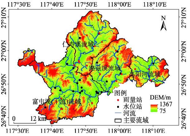
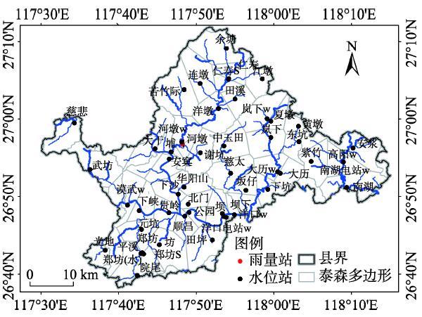
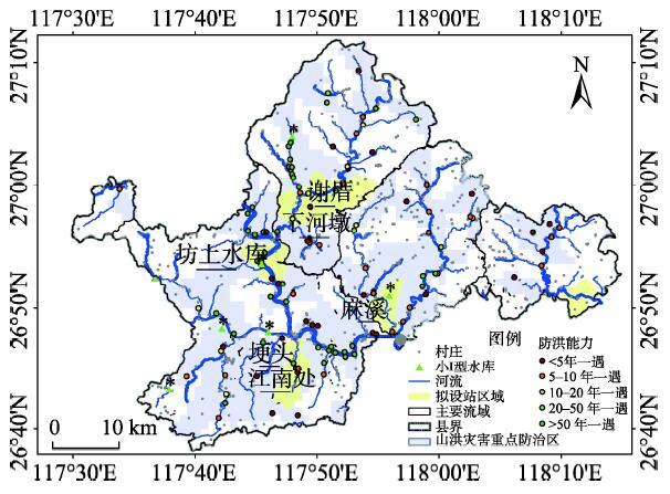
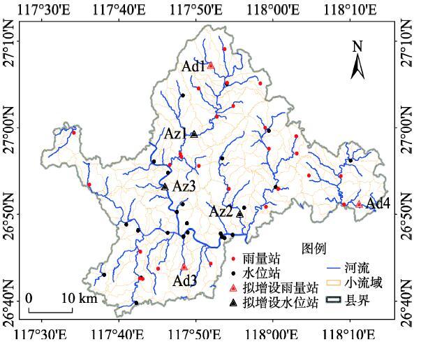