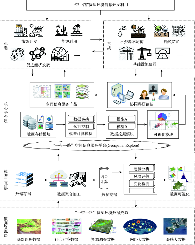
The "Belt and Road" is a major international cooperation initiative proposed by China to adapt to current development needs. It has six economic corridors as its core pillars. The region of interest spans the three continents of Asia, Europe, and Africa, involving a large number of countries with varied regional geographical conditions and complex resources and environment backgrounds. Determination of resources and environmental information along the routes in a systematic and comprehensive manner will play a crucial role in decision-making support for promoting the scientific implementation of the Belt and Road Initiative. Considering the complex background of geographical resources, the environment, and the diverse international cooperation needs, the exploitation and utilization of resources and environmental information along the “Belt and Road” face several opportunities and challenges. This paper proposes a Spatial Information Service System for the Belt and Road Initiative, which is oriented toward collaborative innovation. Two technical routes, top to bottom and bottom to top, are used to demonstrate the overall framework of information acquisition and utilization, and generation of information services for decision support. The progress on resources and environmental information development and services in the six economic corridors is reviewed, including resources and environment patterns and their spatiotemporal evolution, monitoring and evaluation of the United Nations Sustainable Development Goals(SDGs), key technology application in disaster risk reduction knowledge service, resources and environmental information integration and sharing, and the effect of COVID-19 on economic and social development, which can provide a reasonable foundation and reference for the establishment of a comprehensive system for "Belt and Road" resource, environment, and spatial information service. Finally, the development trends and the main directions for potential research and cooperation are highlighted, including strengthening the comprehensive collection and service capabilities of basic resource and environmental data, providing further contributions to data and methods on SDGs target monitoring and evaluation in China, integrating the entire chain of data, information, and knowledge of disaster risk reduction applications, promoting the integration and sharing of resource and environmental data with harmonized standards, and promoting the construction and application of collaborative innovation platforms involving multiple parties. The research would provide a reference for promoting the development and utilization of synchronous data resources, information integration and sharing, and the construction of collaborative innovation application environment of the "Belt and Road" economic corridor, thus, promoting decision-making support for the sustainable development of the "Belt and Road" Initiative.
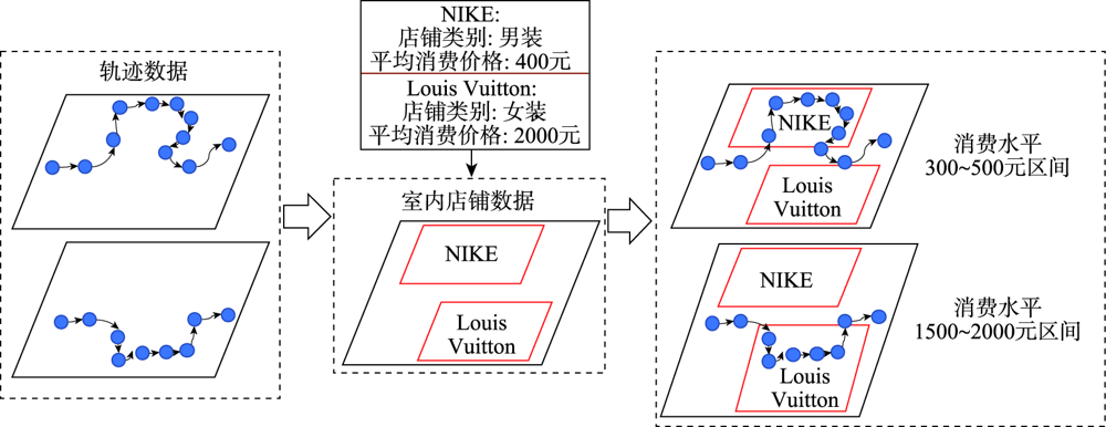
How to obtain the consumption behavior of massive customers in large indoor shopping malls has always been a difficult problem in behavioral geography. However, with the explosive growth of indoor trajectory data in recent years, there's a great opportunity to solve this problem. Meanwhile, the lack of semantic information and poor data quality of indoor trajectory still pose challenges to the inference of consumer behavior. This study proposes a framework for customers' consumption behavior inference in shopping malls without collecting private personal consumption records. This framework integrates the Web text information of stores with movement features extracted from personal and historical customer trajectories. The semantic attributes of indoor stores are enhanced by introducing the crawled network text data of indoor stores, so as to realize the transformation from customer geometric trajectory to semantic trajectory. Specifically, the framework offers a method to model the customers' consumption feature from three aspects, including the raw trajectory's movement feature, semantic feature, and movement embedding feature. By employing the representation learning algorithm in extraction of customers' movement embedding feature, the framework can learn the movement pattern from the historical crowd trajectories and use the movement embedding feature to model movements of a single customer in a complex indoor environment automatically. Finally, the research realizes residents' consuming behavior inference by clustering the concatenated multi-sources consuming features and analyzing the clusters with statistic values and visualization. Through the experimental analysis of a real-world indoor trajectory dataset generated from a large shopping mall with 7045 customers, the inference result proves that the framework can effectively extract the spatial-temporal movement and consumption pattern of residents. Comparing with the classic feature extraction methods and typical clustering methods, the framework we propose achieves an improvement for up to 69.8% in the Silhouette Coefficient. This improvement illustrates that the customers' consumption behavior inferring framework we propose can identify the customers with different consuming behaviors more effectively and cluster customers' feature with high dimension more precisely. Through the analysis of indoor customer clusters' movement pattern, the research finds out that the moving behavior of all shopping mall customers are affected directly and prominently by the design of indoor environment e.g., the distribution of functional zones, location of escalators, etc. Besides, the research also finds out that customers have strong preference to consume in the identical floor. The framework we proposed can identify customer groups with different consumption levels and movement patterns and discover consuming patterns from massive shopping mall customers without knowing their personal information. The application of the framework in inferring customer behavior patterns could provide a support for relative researches in behavioral geography.
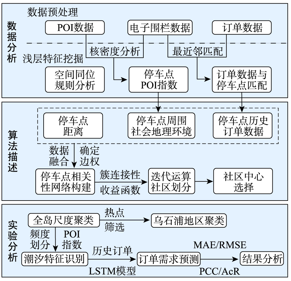
At present, China government and bike-sharing companies mostly use electronic fence parking stations to manage the shared bicycles normatively. Electric fence parking stations for free-floating bike-sharing are predetermined 'virtual fences' to guide users to park bikes in designated zones and regulate inappropriate parking behaviors. However, due to the randomness and uncertainty of the inflow and outflow of bicycles at a single parking station, the scheduling of bicycles based on an independent parking station is hard to realize. Therefore, it is necessary to group fence stations into clusters and implement regional management. In this paper, we proposed a network clustering algorithm based on spatiotemporal constraints, which comprehensively considered spatial factors (location and geographical environment of the parking stations) and temporal factors (historical bike-sharing system orders) as the clustering partition basis, and this algorithm can realize the multi-scale groups division of parking stations only by setting a distance threshold. We chose Xiamen Island as the research region. Using the distance thresholds of 3000 m and 700 m respectively, we carried out clustering experiments on the electronic fence parking stations in the whole Xiamen Island and its Wushipu block. The results showed that this algorithm can not only gather the parking stations with similar temporal and spatial characteristics into the same group, but also make the shared bike flow mainly concentrated in the streets within each group, which is convenient for regional management. Then, we mined the characteristics of shared bikes among the partitioned groups, which can effectively identify and locate hot areas for shared bikes. The results showed that subway stations, office buildings, parks, hospitals, shopping malls, and residential areas had a greater impact on the usage pattern of shared bikes. In particular, it is necessary to focus on the accumulation of shared bikes near office buildings, shopping malls, hospitals, and subway stations, and the shortage of bicycles near the residential areas, parks, and factories during the morning rush hours. Finally, we used the Long Short Time Memory network (LSTM) to predict the orders of shared bikes. The results showed that 84% of the groups had a prediction accuracy of more than 85%, and the average of the overall prediction accuracy was 91.301%, which can meet the needs of bike-sharing system scheduling. Our research provides scientific suggestions for relevant departments to arrange electronic fence parking stations, and the LSTM model has high accuracy in predicting bicycle flow, which is effective in reducing the scheduling cost of bike-sharing system and improve the management efficiency.
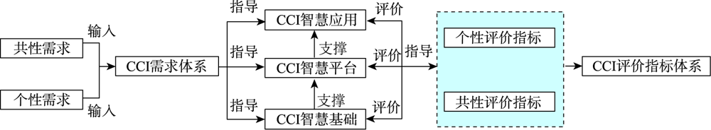
As an important component and microcosm of a smart city, the construction of a smart park is very important, and the evaluation method is a key element in assessing the level of construction and promoting the healthy development of the park. At present, with the rapid development of the new generation of Information and Communications Technology (ICT) and the implementation of advanced concepts such as total life cycle management, the construction and development of smart parks are flourishing. However, little attention has been paid to the evaluation methods that are integrated with them, and there are problems such as slow iteration and single type, which may affect the objective evaluation of the development level of smart parks. In view of this, this study proposes the Commonality Combined with Individuality (CCI) smart park evaluation method, which takes into account the commonality basis and individuality characteristics, based on the advanced inheritance of the original method. The CCI evaluation index system consists of 8 primary indicators, 30 secondary indicators, and 63 tertiary indicators. The common evaluation indicators are the basic indicators common to all parks, which are mandatory and fully integrate the concept of total life cycle management, and are based on the basic structure of the foundation layer - platform layer - application layer of the top-level design of the smart park. The individual evaluation indicators are the characteristic indicators unique to individual parks, which are optional and need to be analyzed according to the actual industrial production process or business content of the park. At the same time, using Shenzhen Smart Ma Wan as an study case, the CCI evaluation index system is constructed and the Analytic Hierarchy Process (AHP) is applied to carry out a comprehensive evaluation, and development recommendations are given in conjunction with the evaluation results: the overall level of Smart Ma Wan is high, which is in line with its target positioning of becoming a benchmark for smart cities in early demonstration zones. However, there is still some room for improvement in the areas of smart platform, smart logistics, smart finance, and smart culture and creativity. Finally, the consistency of the evaluation results with the actual situation of Smart Ma Wan demonstrates the scientific and feasibility of the CCI Smart Park evaluation methodology.
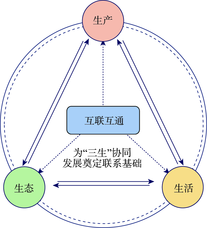
As the progress of reform and opening up, the urbanization in China has experienced extensional and extensive development mode. However, the development model is not sustainable. Considering that urban agglomeration is the main form for promoting the future urbanization, the construction of smart urban agglomeration has become the research focus. The lack of theoretical guidance will lead to certain blindness in construction of smart urban agglomeration. Therefore, this paper aims to build up a theoretical framework for the construction of smart urban agglomeration under the system of "One Connection and Ecological-Living-Production Space System" through the cognition of the essence of "smart" as well as urban agglomeration. The results show that: (1) The construction of smart cities and smart urban agglomeration cannot be separated from the soul guidance of a community of life. Therefore, based on the comprehensive cognition of "wisdom" in psychology, it is proposed that the soul of a smart city shall be oriented to the self-regulation for people oriented, including real-time smart perception, smart assessment, smart optimization, and smart implementation; (2) "Interconnection, Production, Life, and Ecology" (One Connection and Ecological-Living-Production Space System) are the four major sections of spatial systems of smart urban agglomeration; (3) Fulfillment of smart perception, smart assessment, and smart optimization in "One Connection and Ecological-Living-Production Space System" is the core of constructing smart urban agglomeration. Meanwhile, combined with the actual situation of Guangdong-Hong Kong-Macao Greater Bay Area (GBA), the objective and content of constructing GBA urban agglomerations are further studied. In addition, the supporting role of geospatial information technology in GBA urban agglomeration is discussed so as to provide reference for the establishment of theoretical framework of constructing smart urban agglomerations in China.
The Yellow River Basin serves as an ecological barrier in the eastern plain of China. Analyzing the spatiotemporal change of vegetation cover in Yellow River Basin and its topographic effects is helpful for ecological environment management. In this study, we first calculated the annual Fractional Vegetation Cover (FVC) of the Yellow River Basin for 1990—2020 through the GEE cloud computing platform using pixel binary model and Landsat images. Then, the spatiotemporal trend of FVC was obtained through Theil-Sen Median trend analysis and Mann-Kendall test. Finally, the topographic effects on FVC was quantified based on Digital Elevation Model (DEM) data (i.e., SRTM Plus) through ArcGIS. The results show that: (1) the FVC in the Yellow River Basin presented a spatial distribution of low in the northwest and high in the southeast. Low-level FVC values accounted for 45% of the entire basin area, which were mainly concentrated in the arid and semi-arid areas in the northwest; (2) the vegetation coverage in the middle of the basin was improved significantly, which accounted for 57.07% of the entire region. The degradation trend of the northwest and west region was stronger than that in other regions of the Yellow River Basin; (3) the vegetation coverage was significantly affected by the topography. High-level FVC occurred in regions where the slope was greater than 40° and the elevation was between -31~637 m. The vegetation recovery was good within the range of slope of 8~18° and elevation of 1852~2414 m. The results can provide scientific support for the ecological environment protection and high-quality development of the Yellow River Basin.
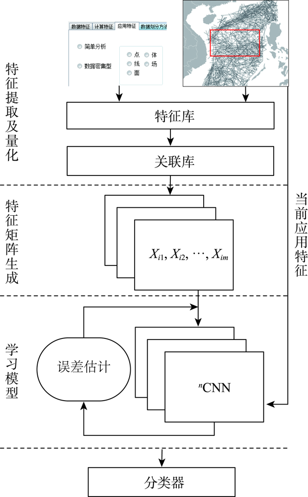
The adaptive data segmentation method is the key technology of data parallel computing automation. However, because data segmentation methods are mostly aimed at specific application scenarios, there is no clear boundary between methods, and the concept definition is relatively vague and general. The method selection results have the characteristics of one sidedness, pertinence, subjectivity, and uncertainty. Aiming at the problem that the spatial data segmentation methods cannot be selected adaptively and making full use of the advantage that CNN can establish end-to-end mapping without regular causality, this paper proposes an adaptive data partition algorithm based on CNN(Adaptive Partition Algorithm for Space Vector Data- Convolutional Neural Networks, SVDAP-CNN,). The algorithm comprehensively considers the factors affecting the selection accuracy and time efficiency of spatial data segmentation methods. Firstly, the feature and relationship between features are extracted through the description and expression of features, and the feature association directed graph is generated; Secondly, based on directed graph and clustering algorithm, the expression algorithm of characteristic matrix is designed to generate sample database. The expression of feature matrix reflects the local correlation between features, which reduces the method selection time and improves the method selection accuracy; Finally, through the combination of CNN model and classification function (softmax), the adaptive segmentation of spatial data is realized. This paper selects the real data of the South China Sea and the simulation data generated by the software for verification and compares it with the existing data segmentation method selection algorithm. Experimental results show that: for the real data with complete and accurate feature description and correlation, the accuracy of SVDAP-CNN algorithm is improved by 24.18% and the time efficiency is improved by 25.67%; for the simulation data with incomplete expression of features and relationship between features, the accuracy of SVDAP-CNN algorithm is improved by 27.02% and the time efficiency is improved by 26.80%; for the data segmentation method with error prone selection results, the accuracy of SVDAP-CNN algorithm is improved by 19.92%, which proves that the proposed algorithm has good applicability; In addition, combined with the practical application in the South China Sea, this paper proves the feasibility of the algorithm. The proposal of SVDAP-CNN algorithm solves the bottleneck problem of automatic data parallel computing and promotes the development of spatial information service to an intelligent and active mode of accurate resource retrieval and rapid construction of topics. The SVDAP-CNN algorithm can provide technical support for a large amount of data and changeable automatic spatial application analysis.
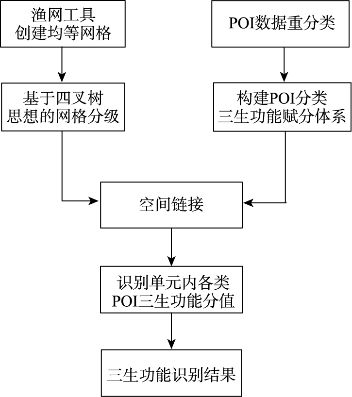
In urban areas, the inner buildings are dense, and the buildings are gradually sparse in the periphery. Therefore, there is always a phenomenon that the POI data density in the inner area is high, and the POI data density in the periphery area gradually decreases. At present, the equal grid created by fishing net tool is often used as the identification unit to carry out the recognition of "The Production, Living, and Ecological space"(PLES) for urban areas. But in the process of recognition, there will be two situations: if the grid scale is large, the recognition accuracy may be low; if the grid scale is small, then it may cause more data-free areas. To solve the above problems, this paper proposes a method of identifying the PLES based on POI data and the idea of quad-tree. By comprehensively utilizing POI data of Internet map, administrative division, remote sensing images, and other data, we introduce the idea of quad-tree to classify grid identification units. We connect POI data with urban construction land classification and land use status classification to reclassify POI. Based on the function and area of various POI, a POI classification of "The Production, Living, and Ecological Function" score system is constructed to quantitatively identify PLES. Then taking Xi'an central urban area as the experimental area for method verification, the recognition results were sampled and compared with the visual interpretation results from remote sensing images and the current land use map. The experimental result shows that the correct rate was around 95%. By comparing with the results obtained by using the equal grid for recognition of PLES, the introduction of the quad-tree idea to classify the grid has the following advantages: in view of the low density of POI data in the periphery of the city, the introduction of quad-tree idea to merge grids can effectively reduce the existence of data-free areas and improve the utilization of less POI data in the periphery of the city; for areas with dense POI data within the city, using small-scale grids as the identification unit can give full play to its large data volume and improve the accuracy of the identification results of the PLES in the urban area. This method provides a new idea for the identification of the PLES for urban areas based on POI data.
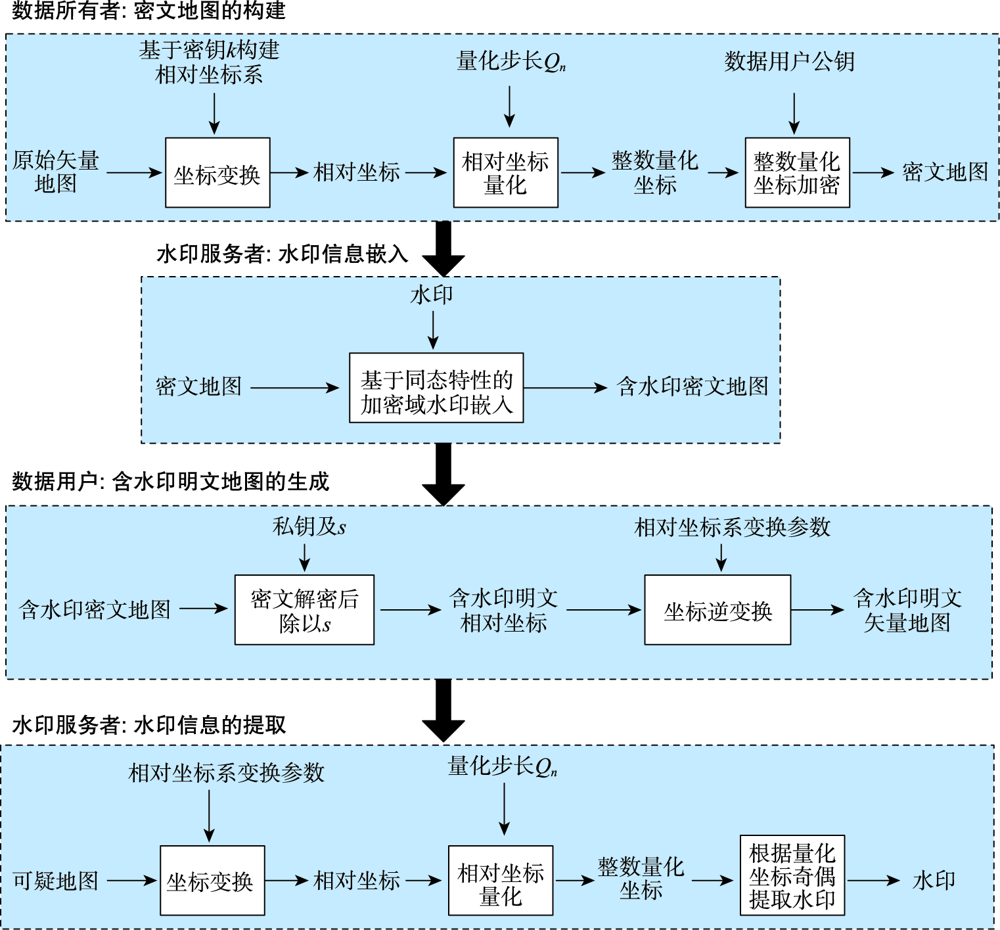
Homomorphic encryption technique can be used for protection of data privacy, and some algebraic operations can be implemented on the ciphertext data. This is very useful in the field of cloud computing security, such as analyzing and processing the encrypted data in cloud without exposing the content of data. Based on this feature, aiming at the map watermarking system in cloud, this paper first proposes a robust vector map watermarking algorithm in homomorphic encrypted domain. The main ideas are as follows: (1) Firstly, the original map coordinates are transformed into relative coordinates. Secondly, the relative coordinates are quantized into integer coordinates based on a predefined quantization step. Lastly, the integer quantization coordinates are encrypted by using the homomorphic encryption system, obtaining the ciphertext map; (2) The map watermarking system in cloud directly embeds the watermark into the ciphertext map based on the homomorphism of the encryption system; (3) In the receiver side, the data user decrypts the watermarked ciphertext map, and performs inverse coordinate transformations to the decrypted map, obtaining the final watermarked plaintext map. A series of simulation experiments are done to evaluate the invisibility and robustness of the watermark. The experimental results show that the watermarking algorithm in the homomorphic encrypted domain proposed in this paper has good invisibility and robustness. Especially, it is robust to RST geometric attacks.
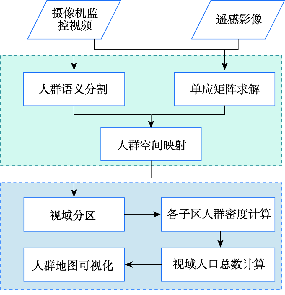
Aiming at the problem that the existing crowd counting methods cannot achieve accurate counting and map visualization of complex crowds, a crowd density estimation method considering video geographic mapping is proposed. Firstly, based on Deeplab V3+model, a crowd semantic segmentation model suitable for complex scenarios is constructed by transfer learning. Combining video with GIS, the high-precision homography matrix between video and crowd scene map is calculated according to four or more pixel coordinates between video frame and the corresponding geographic coordinates. Based on the crowd semantic segmentation model and the solved homography matrix, the crowd areas in videos are projected to the map. Secondly, to improve the accuracy of crowd number, two different partition schemes: equidistant and grid partition, are designed to divide the camera Field of View (FOV). According to the semantic segmentation result, the crowd density of each sub-region using different partition schemes is counted. Based on the crowd density and area of each sub-region, the total number in the camera FOV is calculated. Thirdly, based on the solved homography matrix, the semantic segmentation result of the crowd in the real-time video can be projected to the 2D map and the crowd number can be counted through the crowd density. In order to obtain accurate crowd density, we took a playground as the experimental area and collected multiple crowd surveillance videos at different times and under different crowd conditions. The experimental results show that: (1) the crowd semantic segmentation model constructed in this paper can achieve high-precision crowd segmentation in large scenes, with an accuracy of 94.11%; (2) Combining video with GIS, the polygon area of the crowd was filled through the point symbol of person style, the crowd mapping and visual expression were realized, and the goal of crowd localization, measurement, and spatial analysis was achieved; (3) Accurate counting of surveillance video crowd was realized, and the camera FOV was divided into many sub-areas, which is conducive to improving the crowd counting accuracy. Compared to the crowd density estimation method based on density map, the method proposed in this paper is suitable for large scenes with high altitude and high density, especially in the areas where the texture of people's head isn't clear and crowd characteristics are obscured. Our method can effectively improve the accuracy of crowd counting and map visualization and can be used for crowd supervision in large-scale events, stations, shopping malls, and sports venues.
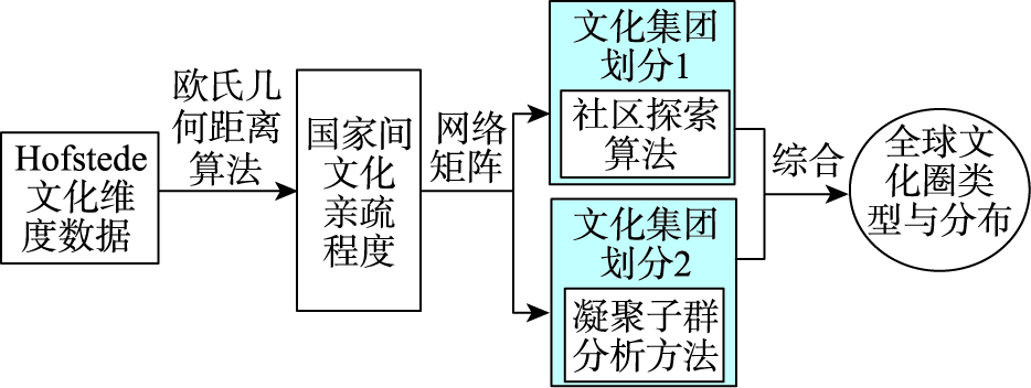
The shaping of the world pattern by culture is invisible but far-reaching. In the current researches, there are few quantitative analysis on cultural affinity from the spatial perspective. Therefore, by using national culture datas in Hofstede's Insights, this paper introduces the Euclidean distance to measure the cultural affinity between nations, and then uses the community detection algorithm and cohesive subgroup analysis to divide all nations into different cultural groups, so as to depict the spatial pattern of cultural affinity. The results show that: (1) The cultural affinity between China and the other countries varies from intimate to estranged Neighboring Asian countries are the most intimate with China, and a few countries in the Caucasus, the Balkans, and Sub-Saharan Africa also have close relationship to China. The countries with inapparent intimate cultural relations with China are widely distributed in the intermediate zone, including Western Asia, North Africa, Central and Eastern Europe, and a few countries in Sub-Saharan Africa and South America. The countries with more distant relationship to Chinese culture are mainly distributed in Western Europe, North America and Oceania, Sub-Saharan Africa, and South America, and the Northern Europe has the least cultural affinity with China; (2) There are eight cultural circles in the world, including Anglo-Saxon, Northern Europe, Continental Europe, Latin, Orthodox, West Africa-Caribbean, Islamism, and Pan Asia. Among them, Anglo-Saxon, Northern Europe, Continental European, and Latin cultural area are closely related with each other, forming the European-American cultural circle.
The spatialization of population at a fine resolution can reflect the explicit size and detailed distribution of the population. It can provide fine-scale data sources for scientific research and policy making. As a national key area of urbanization development in China's main functional zoning and the intensive area of optimizing the development strategy layout, the Bohai Rim Region is one of the areas with relatively high population density and developed economy in China. In this study, the random forest model was applied to multi-source data and points of interest to estimate the population distribution in impervious areas with a spatial resolution of 30 m in the Bohai region. The estimated results were compared with those of the World Pop dataset and other regional studies with the same spatial resolution. Based on the results, the importance of input variables was analyzed. The results showed that the overall accuracy of the simulation predicted in this study was 10% higher than that of the World Pop dataset. Compared with the World Pop population data, the 30-m resolution of our result provided detailed information of population distributions in the Bohai Rim Region. ?Compared with research results in other regions at the same resolution, the accuracy was partially improved. Built-up areas and points-of-interest were the most important indicators of population distribution in the Bohai Rim. Social factors had a higher correlation with population distribution. The main factors affecting the population distribution varied from region to region.
The ecological protection and high-quality development of the Yellow River Basin is a major mission in the new era of China, and the air pollution abatement is among the necessities of the high-quality development. It is of great significance to explore the spatiotemporal variation of PM2.5 and its socio-economic influencing mechanisms for the air pollution abatement and high-quality development of the Yellow River Basin. By conducting time series estimation, spatial autocorrelation analysis, geodetector, and geographically weighted regression, this paper reveals the spatiotemporal variations and trends of PM2.5 concentration from 2015 to 2020 in the Yellow River Basin, and quantitatively explores the driving mechanism of socio-economic factors on both watershed scale and city scale. The main findings are as follows: (1) During the study period, the Yellow River Basin has an overall reduction in PM2.5 pollution. The PM2.5 concentration decreases with a fluctuating downward trend of 4.2 μg/m3 per year on average; (2) The PM2.5 concentrations in Shandong and Henan are high but decrease fast, whereas the concentrations in Shanxi and Shaanxi are also high but decrease slowly; (3) Future prediction based on the current trend shows that among the 61 cities in the Yellow River Basin, 54 cities will achieve the goal asserted in the 14th Five Year Plan of China, which proposes to reduce PM2.5 concentration by 10% in 2025. However, it would be a struggle for other 7 cities, i.e., Jincheng, Xi'an, Yulin, Taiyuan, Linfen, and Yuncheng, to meet the policy requirement due to their heavier pollution and slower improvements; (4) Population density, industrial enterprises amount, and land use intensity are the main socio-economic factors leading to the increasement of PM2.5 concentration in the Yellow River Basin, of which the explanatory power reached more than 50%; (5) From 2015 to 2019, the main regions influenced by high land use intensity and population density are transferred to the central part of the Yellow River Basin, which indicates that Shanxi, Shaanxi, and Inner Mongolia should be regarded as the key area to carry out the PM2.5 control programs; (6) Promoting the urban-rural development coordinated with environmental carrying capacity, as well as controlling the industrial scale and improving the environmental protection level of industrial enterprises are practical strategies to control the PM2.5 pollution in the Yellow River basin. Findings of this study are expected to provide theoretical reference for relevant decision makers in order to boost the high-quality development of the Yellow River Basin.
A reasonable spatialization of urban carbon emissions is an important prerequisite for formulating clear carbon emission reduction policies. However, previous studies relied heavily on the nighttime light data with coarse spatial resolution and did not consider the huge differences of carbon emissions between various industry sectors. Therefore, the corresponding results cannot accurately reflect the spatial distribution of carbon emissions. To solve the disadvantages of previous methods, this study proposed a more reasonable method for the spatialization of carbon emissions. Firstly, three statistical models were used to estimate the carbon emissions of various industry sectors for Guangzhou in 2019. Next, the spatial distribution of carbon emissions was simulated based on the combined use of Luojia1-01 nighttime light and urban functional zoning data. Based on the spatialization result, both the global and local spatial autocorrelation analyses were carried out to reveal the spatial characteristics of carbon emissions in Guangzhou. Finally, the random forest model was used to investigate the socio-economic driving factors behind the carbon emissions in Guangzhou. The results are summarized as follows: (1) Although the carbon emissions of Guangzhou increased slowly after 2011, the total emission volume still reached 83.12 million tons in 2019, in which the transportation sector played a dominant role; (2) Compared with the commonly-used ODIAC (1 km), EDGAR (10 km) carbon emission products and the carbon emission spatialization results based on NPP-VIIRS (500 m), the result generated by high resolution (130 m) nighttime light and urban functional zoning data can more accurately characterize the spatial differences of carbon emissions; (3) There was a significant positive global spatial autocorrelation of carbon emissions in Guangzhou, resulting in highly concentration areas of secondary and tertiary sectors; (4) The main influencing factors for the secondary sector's carbon emissions were public budget revenue, GDP of the secondary sector, public budget expenditure, and fixed asset investment. In comparison, the major contributors to the tertiary sector's emissions were retail sales of consumer goods, GDP of the tertiary sector, GDP per district, and population. In summary, this study carefully considers the differences in industry structure, and then utilizes the high-resolution nighttime light data to investigate the distribution pattern of carbon emissions. The results will be helpful for policy-makers to formulate reasonable carbon emission reduction and industrial optimization strategies.
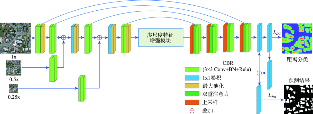
Extraction of buildings from High Spatial Resolution Imagery (HSRI) plays an important role in remotely sensed imagery application. However, automatically extracting buildings from HSRI is still a challenging task due to factors such as large-scale variation of buildings, background complexity, and variation in appearance, etc. Especially, it is difficult in extracting both crowded small buildings and large buildings with accurate boundaries. To address these challenges, this paper presents an end-to-end encoder-decoder model to automatically extract buildings from HSRI. The designed network is called multiscale feature enhanced U-Shaped CNN with attention block and edge constraint (MAEU-CNN). Firstly, a Multiscale Feature Fusion (MFF) module is adopted in the encoder part of the network, which enables the network to aggregate features from multiple scales. Then, a Multi-scale Feature Enhancement module (MFEF) is added between the encoder and decoder parts to obtain multiscale receptive fields for obtaining multiscale context information. Thirdly, a dual attention mechanism is introduced to adaptively select representative feature maps for extraction of buildings instead of direct skipping connections. Lastly, in order to further solve the problem of segmentation result with poor boundaries aroused by the pooling operations in the MAEU-CNN, the geometric information of building boundary is introduced into the proposed MAEU-CNN by multi-task learning using the distance class map to produce fine-grained segmentations with precise boundaries. The performance of MAEU-CNN is examined through two different data sets at different building scales. The results show that MAEU-CNN obtains the greatest accuracy in each data set. The Precision, F1, and IoU is 93.4%, 93.62%, and 88.01%, respectively using the ISPRS Vaihingen semantic labeling contest data set. The Recall, F1, and IoU reach 95.45%, 95.58%, and 91.54%, respectively, using the WHU aerial image data set. Experimental results demonstrate that our proposed MAEU-CNN can achieve high accuracy for the extraction of building from remotely sensed imagery and show great robustness at different scales.
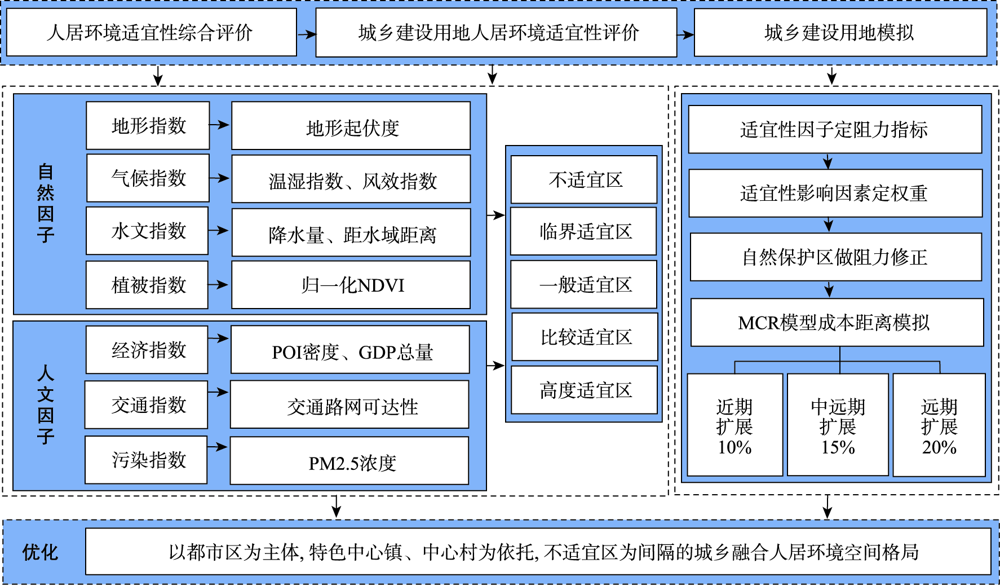
Currently, urbanization is not synchronized with the development of urban and rural living environment under the background of rapid economic development. The urban and rural environmental construction generally pays much attention to the production space rather than the living space. The area and quality of urban and rural living space cannot adapt to the development of economy and society. Therefore, scientific evaluation of the suitability of human settlements environment is the premise of land sustainable development, which is significant to improve the carrying capacity of environment and promote the harmonious development between human beings and nature. Taking Inner Mongolia autonomous region as an example, this paper evaluates the suitability of human settlements environment from both natural and human aspects based on conditional rule integration method, then takes the suitability as the limiting factor of urban and rural construction and expansion. The Minimal Cumulative Resistance (MCR) model is used to simulate the urban and rural construction land, and the spatial optimization scheme of regional human settlements is proposed. There are four major findings reported as follows. Firstly, the hydrological and climatic conditions have a strong restrictive effect on human settlements in the study area. Secondly, the proportion of critically suitable and unsuitable areas is the highest, and the proportion of highly suitable area is the lowest. Moreover, the proportion of relatively suitable and highly suitable areas of urban and rural construction land is large. From the spatial domain, the suitability of the south is better than that of the north, and the east is better than the west. Overall speaking, the unsuitable and critically suitable areas of human settlements environment are mainly caused by the unsuitable natural conditions and unreasonable occupation of nature reserves. Third, the simulation result of urban and rural construction land shows that the long-term integration trend of Hohhot-Baotou area is obvious. It can gradually form a spatial pattern of urban rural integration with Hohhot-Baotou-Ordos metropolitan area and Chifeng-Tongliao metropolitan area as the main body, central towns and villages with distinctive cultural characteristics and perfect public facilities as the support, and unsuitable residential areas as the separation. Based on the empirical study of human settlements environment in typical areas, we can not only provide suggestions for the construction of human settlements in our study area, but also provide experience and reference for other similar areas.