曹青 , 洪必文, 阮陵
CAO Qing, HONG Biwen, RUAN Ling
通讯作者:
收稿日期: 2018-06-19
修回日期: 2018-10-3
网络出版日期: 2018-11-20
版权声明: 2018 《地球信息科学学报》编辑部 《地球信息科学学报》编辑部 所有
基金资助:
作者简介:
作者简介:曹 青(1992-),女,硕士生,主要从事空间认知与地图可视化。E-mail: 2454295083@qq.com
展开
摘要
自然语言和地图都具备表达地理实体空间关系的能力,自然语言使用方便、抽象化程度高,而地图更为直观,从自然语言转换到地图,有助于人们更深入地了解自然语言描述的地理实体空间关系。然而,如何让计算机具有从自然语言构建图形信息的能力,使计算机具有智能化空间认知思维是当前研究的难点。本文总结了自然语言空间关系描述的类型及特点,提出了基于自然语言描述的地理实体抽象表达方法以及空间关系近似转换方法,建立了一种基于自然语言空间关系描述的地图近似表达策略。实验结果表明,本文方法有效可行,能够实现定性描述的自然语言空间关系向定量(或近似定量)的图形空间关系的转换,为自然语言到地图的转换研究奠定了基础。
关键词:
Abstract
With the further development of mobile GIS, intelligent GIS and socialized GIS, the geospatial information service based on natural language processing is an inevitable trend in the field of geographical information science. The intelligent conversion from text to map is one of the important research directions. Both natural language and maps have the ability to express spatial relationship of geographical entities. Natural language has the natural characteristic of usability and is highly abstract, while map language is more intuitive and revealing. The ubiquitous natural language contains a great deal of geographic information. Converting natural language to map language can help people intuitively understand the geographic space environment and bring out new discoveries. The current research difficulties focus on that how to make a computer construct graphical information from natural language and have the intelligent spatial cognitive thinking ability. This paper proposes a method that using point coordinated pairs, straight line segments and rectangular/circular shapes to quantitatively represent point, polyline and polygon geographical entities in natural language respectively. First the spatial relations description types in natural language between point and point, point and line, point and surface, line and line, line and surface, surface and surface geographic entities are summarized. Second, approximate transformation model of spatial relationships in natural language which considering the geometric types of geographical entities is constructed, and an approximate expression strategy based on spatial relationships description in natural language is proposed. Third, a prototype system is designed to implement "text-map" conversion, and scenic spot travel notes are selected as the experimental text to finish the experiment. The experimental results showed that the method mentioned above was feasible, the goal that converting qualitative spatial relationships in natural language to quantitative (or approximately quantitative) graphical spatial relationships could be achieved. This paper lays a foundation for the study of the conversion from natural language to map.
Keywords:
自然语言是人机交互手段之一,同时蕴含大量地理空间信息。在智能化时代背景下,以自然语言处理为基础的地理信息服务是地理信息科学领域的必然发展趋势,从自然语言空间关系描述到图形空间关系的转换是其中重要的研究方向。
近年来,针对自然语言空间关系的研究集中在2个方面:①自然语言空间关系定量化,其中拓扑关系中较成熟的是四交模型[1]和九交模型[2]。 Egenhofer等[3]、Mark等[4]和Shariff等[5]利用九交模型研究了拓扑关系的定性描述及其与空间认知的关系;许珺[6]从线状实体空间关系出发,选取了角度、分裂度等度量指标,结合拓扑关系定量指标,形式化描述了自然语言空间关系词汇。方向关系中有锥形方法[7,8]、投影方法[9]、最小外接矩形方法[10,11]等。Frank[8]基于投影方法提出用东、南、西、北等八方向,再加上“同一”方向描述空间对象间方向关系;Clementini[12]指出若没有参照物的描述信息,其方向关系词汇的含义不明确,因此他为方向关系和其相关参照物确定了统一的参考框架,并构建方向关系和五交模型之间的映射函数;杜世宏等[13]提出一种新的细节方向关系,结合外部方向关系和拓扑关系,提出了更全面的自然语言描述方式。距离关系描述方式包括定量和定性描述。Minock等[14]对“远”、“近”距离关系进行探索,在传统的赋值受限文本方法上加以改进,对一组无约束的阈值参数设定规则,通过固定参数算法获得与上下文描述“远”和“近”场景训练语料一致的参数,应用于自然语言模糊查询。②自然语言空间关系可视化,该类研究旨在从自然语言描述中提取空间关系并将其转换为合理的草图,近年来在位置描述的空间定位[15,16,17]、路径描述[18,19,20,21,22,23]和场景描述[24]的图形可视化方面取得了一些初步成果,把自然语言描述的地理实体统一抽象为点或一个特定符号,没有顾及到自然语言描述的地理实体的几何类型、形状、大小等空间特征。
上述研究为自然语言空间关系到图形空间关系的转换奠定了基础,侧重于自然语言空间关系的定量化描述,且建立在地理空间数据已知的基础上,用于空间关系的自然语言查询,而对自然语言空间关系的可视化表达方面尚处于起步阶段,研究成果较少,侧重于自然语言空间关系的简单草图可视化,把自然语言描述的地理实体统一抽象为点或一个特定符号,没有顾及到自然语言描述中地理实体的空间形态特征描述。如何顾及这些特征描述,将不同类型地理实体间自然语言空间关系转换为图形空间关系尚缺少研究。因此,将自然语言描述的地理实体用近似定量的抽象几何符号表示,以及如何将地理实体间自然语言空间关系转换为图形空间关系是本文研究重点。
自然语言中描述地理实体及其空间关系的短语、句群、段落、篇章称为自然语言空间关系描述,主要包括地理实体描述和空间关系描述,其中地理实体描述分为名称描述、空间形态描述、属性描述,空间关系描述分为拓扑关系描述、方向关系描述、距离关系描述。
由于自然语言的灵活性、多样性、模糊性和不确定性,自然语言空间关系描述也表现出相应的特性,体现在:① 地理实体描述一般为特殊名词或短语标识,这种实体的信息通常不全面,即使某些语句会对实体的属性加以说明,但大多数情况下仍无法准确获得地理实体的大小、形状等空间形态特征;② 拓扑关系描述词汇丰富,同一拓扑关系有多个拓扑词汇对应,而部分拓扑词汇在不同语境中能表达不同的拓扑关系;③ 方向关系描述可分为绝对方向关系和相对方向关系描述,其中相对方向关系需要根据人的朝向将其转换为绝对方向才能准确定位,而绝对方向描述的“东”与“北”、“东”与“南”等方位之间也无法划定一条截然分明的界限;④ 距离关系描述包括定量距离、定性距离、时间距离描述,其中定性距离描述的“远”与“不远”、“近”与“不近”之间的界限并不明确,即使是同一定性距离词汇,在不同语境中对应的距离也不同,如“南京离合肥较近”对应“距离170公里左右”,而“南师大离警官学院较近”对应“距离200米左右”,二者描述尺度不同,对应的距离存在数量级上的差异,因此,需要根据实验区域的尺度特征或通过对人群进行认知实验将其近似转换为定量距离;而时间距离也无法精确计算,需根据词语含义将其近似转换为定量时间,进而转换为定量距离,如“一袋烟”对应3-5 min,步行大概350 m 。
(1)地理实体抽象原则
按照地理实体的几何特征,可将其分为点状实体、线状实体、面状实体3类。通过对自然语言中地理实体描述的分析,结合实体本身的形态特征以及人的认知经验,本文提出将自然语言描述的地理实体抽象为点、线、面,需要考虑实体形状、实体属性、实体面积占比、实体是否为独立个体等要素,其中,实体面积占比指实体占地面积与研究区域占地面积的比值;实体是否为独立个体指实体内部有无其他实体,若实体内部无其他实体,则不论抽象为点还是面都不影响实体间空间关系的表达。
① 点状实体:若实体为独立个体,面积占比小且无重要属性时,无论将其抽象为点或面都不影响其与其他实体的空间关系,可将该实体抽象为点实体;
② 线状实体:若实体外接矩形的长宽比明显较大时,可将该实体抽象为线实体,如桥、长廊、河流等;
③ 面状实体:若实体不是独立个体,其内部还包含其他需要表达的实体,则将其抽象为面实体;若实体是独立个体,面积占比大时,将其抽象为面实体;若实体是独立个体,面积占比小,但有重要属性时,将其抽象为面实体。
(2)地理实体简化模型
对点实体而言,本文采用(x , y)坐标对其近似表达。
对线实体(如道路、河流)而言,有直线、曲线、折线之分,很难建立统一模型来表达,因此本文以笔直道路为例,采用直线段近似模拟。此外,对于描述中涉及线实体形状的(如弯弯曲曲的河流),本文将对直线段模型稍加改进,采用曲线模型对其模拟表达。
对面实体而言,一方面,语言描述的面实体高度概括,没有界定其范围;另一方面,虽然现实世界中面实体较复杂,难以用统一模型表达,但根据它们的形状特征,可大致抽象为几个特定的规则图形,如建筑物可抽象为矩形、湖泊可抽象为圆形或椭圆、长江三角洲可抽象为三角形等。本文以建筑物为例,采用矩形模型对面实体近似表达,其他规则面状模型将按类似方法处理。
空间关系中拓扑关系约束着方向和距离关系的使用:当拓扑关系为相离时,主要描述距离、方向关系,当拓扑关系为包含、相接、相交时,主要对拓扑或方向关系加以描述。因此按照拓扑关系进行划分,构建点状、线状、面状参照物的相离、包含、相接、相交关系描述的近似转换模型。
3.2.1 相离关系
(1)仅拓扑
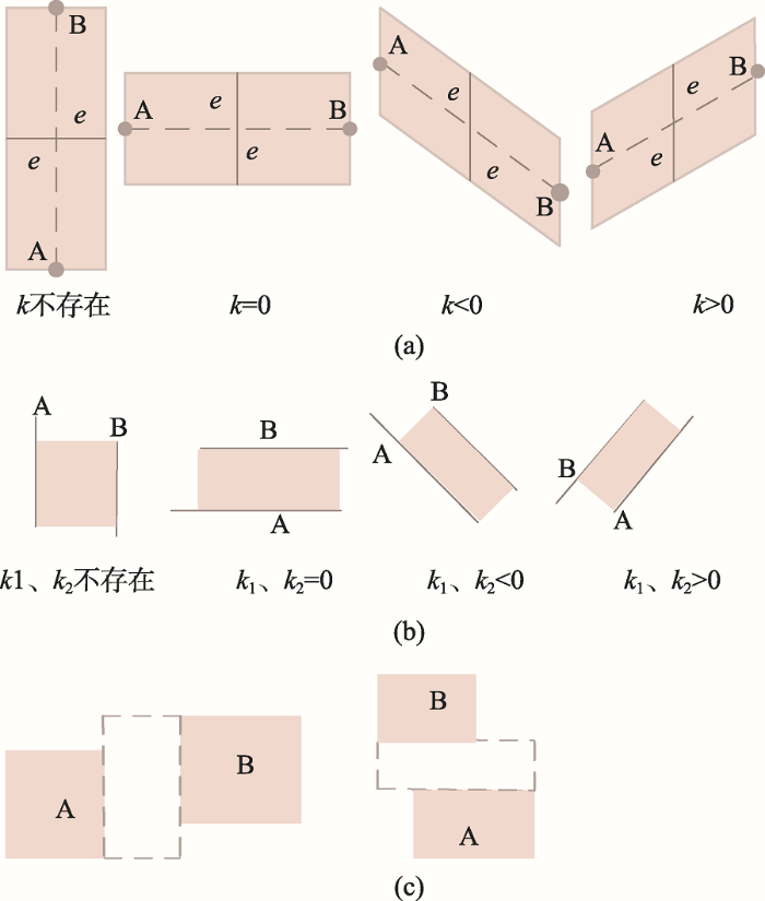
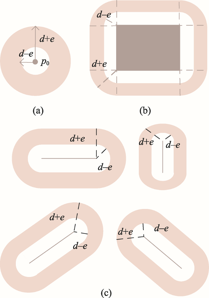
目标物在点状参照物A和B之间:以参照物A、B的连线为中轴线,引入误差e,如图1(a)中的灰色区域即为目标物的候选区域范围(k为A、B连线的直线斜率)。
图1 “在参照物A和B之间”关系模型
Fig. 1 Relationship model of “Between reference object A and B”
目标物在线状参照物A和B之间:根据线A、B的走向不同建立不同的模型(k1、k2分别为线A、线B的斜率),如图1(b)的灰色区域即为目标物的候选区域范围。
目标物在面状参照物A和B之间:根据A、B的相对位置建立模型,如图1(c)的虚线矩形框区域即为目标物的候选区域范围。
(2)方向关系
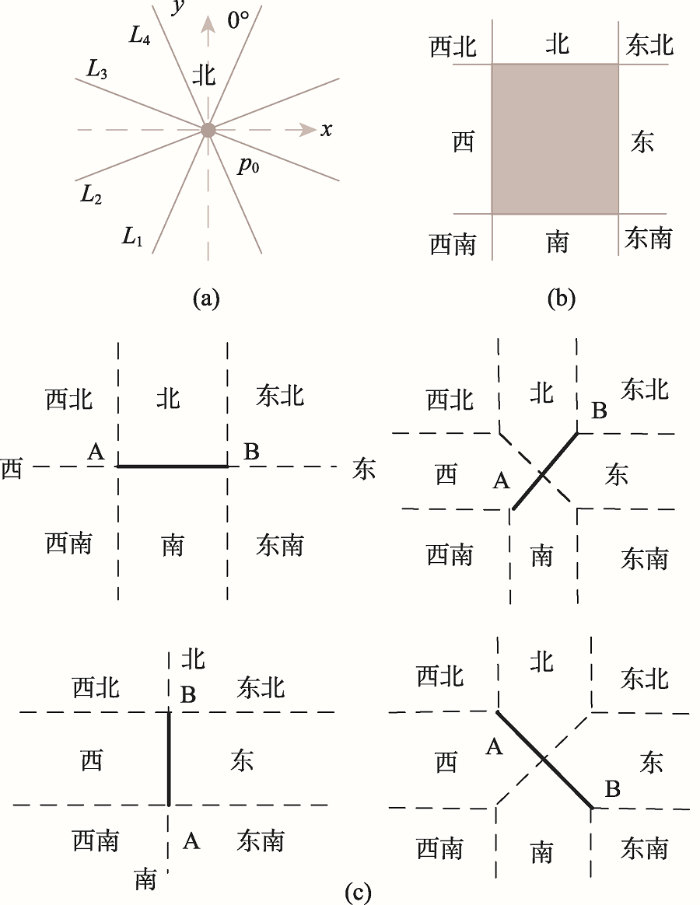
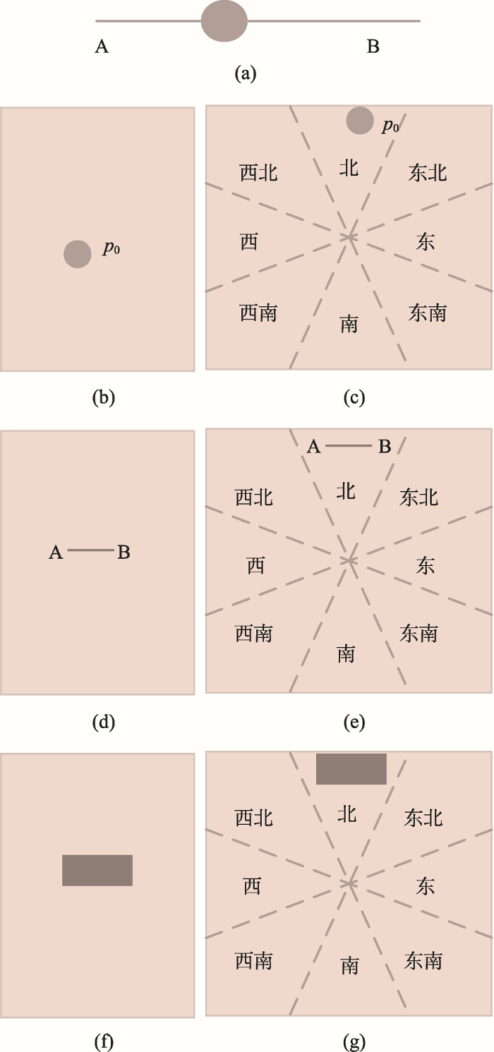
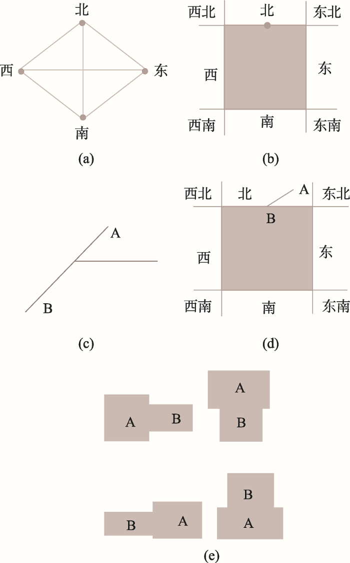
点状参照物:采用八方向锥形模型,将二维空间平分为八个区域,如图2(a),设定北方向为[0º, 22.5º] ∪ [337.5º, 360º],沿着顺时针方向每隔45°设定为一个方向,则各个方向的划分顺序依次为北、东北、东、东南、南、西南、西、西北。
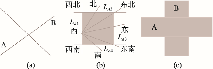
线状参照物:以Frank提出的投影方向模型为基础,根据线的走向建立方向模型(k为线AB的斜率),如图2(c)。
面状参照物:采用投影方向模型,如图2(b)。
(3)距离关系
点状参照物:人们对空间的认知存在一定偏差,用自然语言描述的距离通常不完全与实际相符,因此在对距离的位置估算中,引入误差参数e, e随着定量描述数值(用d表示)的增大而增大,但由于个体的空间认知能力存在差异,需要通过不同个体空间位置判断能力测试来确定e和d之间的关系。如图3(a),深色圆环区域表示目标物距离参照物长度为d的候选位置。
线状参照物:根据点状参照物的描述原则,确定误差参数e。根据线的走向建立距离关系模型,如图3(c),深色圆环区域表示目标物距离参照物长度为d的候选位置(k为参照物的斜率)。
面状参照物:根据点状参照物的描述原则,确定误差参数e,如图3(b),灰色区域表示目标物距离参照物长度为d的候选区域。
(4)“方向+距离”关系
将上文中方向和距离关系模型结合,如图4(a)、4(b)、4(c)分别为点状、面状、线状参照物的“方向+距离”关系模型。
3.2.2 包含关系
自然语言中包含关系描述分4类:① 线穿过点(图5(a));② 点在面内,按描述中是否提及方向,分为“点在面内任意方向”(图5(b))和“点在面内某个特定方向”(图5(c));③ 线在面内,按描述中是否提及方向,分为“线在面内任意方向”(图5(d))和“线在面内某个特定方向”(图5(e));④ 一个面在另一个面内,按描述中是否提及方向,分为“在面内任意方向”(图5(f)和“在面内某个特定方向”(图5(g))。
3.2.3 相接关系
自然语言中相接关系描述分3类:① 点与线相接,通常与方向词汇组合描述,如东起,西至、南毗、北邻等(图6(a));② 点与面相接,与方向词汇组合描述,表示为点在面的某个方向的边界上(图6(b));③ 线与线相接,表现为线的某个端点在另一条线上(图6(c));④ 线与面相接关系与方向词汇组合描述,表示为线与面的某个方向的边界相接(图6(d)); ⑤ 面与面相接,表示一个面的一条边与另一个面的一条边重合(图6(e))。
3.2.4 相交关系
自然语言中相交关系描述分3类:① 线与线相交与某个交点处,如图7(a)所示;② 线与面相交,通常与方向词汇组合描述,如图7(b)所示;③ 面与面相交,如图7(c)所示。
本文从全局角度出发,将自然语言空间关系描述文本整篇读入,提取出其中所有的实体和空间关系对,然后分别计算各实体的相对位置范围,并在所求范围内绘制实体,地图近似表达算法具体步骤如下:
(1)输入一段自然语言空间关系描述文本;
(2)提取描述文本中地理实体序列G(G={ G1 , G2 , … , Gn })以及空间关系序列R (R={ R12 , Rij… }),其中Rij表示Gi与Gj的自然语言空间关系,默认G中实体的初始角色为目标物;
(3)从R中找关联空间关系最多的Gmax作为定位基点,并将其角色变更为参照物;
(4)读取G集合,判断G中实体角色是否都为参照物,若是,则转到步骤(8),否则转到下一步;
(5)读取当前角色为目标物的实体Gk,从R中查找与Gk相关联的空间关系记录;
(6)判断空间关系记录中与Gk有关系的参照物个数,若Gk仅有1个角色为参照物的关联实体Gm,则根据Rkm选择3.2中对应模型计算Gk位置范围,并在对应范围内绘制Gk;若Gk有多个角色为参照物的关联实体Gm , Gn , Gl,则根据Rkm , Rkn , Rkl选择3.2节中对应模型分别计算Gk范围,然后将其交集作为Gk位置范围,并在对应范围内绘制Gk;
(7)将Gk的角色变更为参照物Lk,转到步骤(4);
(8)输出模拟表达结果图。
利用C#编程语言,采用基于GDI的程序实现方法,在Visual Studio 2010集成开发环境下开发原型系统,系统包含“语义解析”和“文-图转换”两大功能。语义解析采用关键词匹配及人工辅助方法,从自然语言文本中提取地理实体及空间关系序列;文-图转换包含3步:① 根据本文近似表达策略,计算各地理实体相对位置范围;② 根据自然语言描述的地理实体符号化方法(本文不做阐述),确定各地理实体符号;③ 将确定的地图符号随机绘制在所求空间位置范围内,实现地理实体空间关系的近似拟表达。为验证本文方法可行性,选取一段颐和园导游词作为实验文本,对系统功能进行验证,部分案例实现如表1所示。
表1 地图近似表达案例
Tab. 1 Map approximate expression case
| 类型 | 示例 | 解析结果 | 模拟表 达结果 | ||
|---|---|---|---|---|---|
| 参照物 | 空间关系 | 目标物 | |||
| 拓扑关系 | 长廊位于昆明湖和万寿山之间 | 昆明湖、万寿山 | 在……之间 | 长廊 | 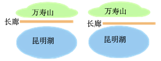 |
| 方向关系 | 宜芸馆位于玉澜堂北面 | 玉澜堂 | 北面 | 宜芸馆 |  |
| 距离关系 | 仁寿殿距离东宫门很近 | 东宫门 | 很近 | 仁寿殿 |  |
| 多种空间关系组合 | 昆明湖中有一座南湖岛,由一座美丽的十七孔桥和东岸相连,十七孔桥东侧有个廓如亭,它与十七孔桥及南湖岛连接在一起。 | 昆明湖 | 包含+南 | 南湖岛 | 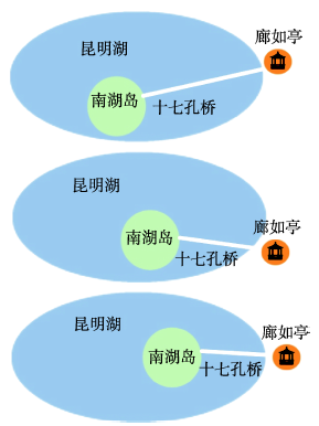 |
| 南湖岛 | 相接+东 | 十七孔桥 | |||
| 十七孔桥 | 相接+东 | 廊如亭 | |||
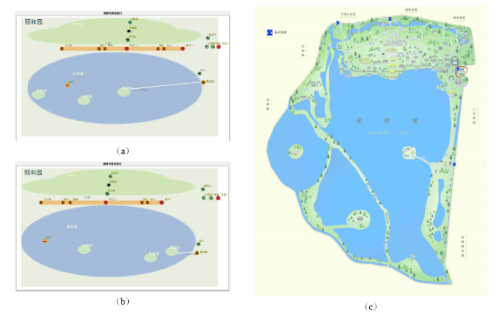
为客观评价本文方法的有效性,选取“地图相似性”作为评价指标,计算本文系统随机生成的5幅地图(图5(a)、(b)为其中的2幅)和颐和园官网的1幅导览图(图5(c))之间的平均相似度,根据相似度大小对实验结果进行定量评估。地图相似性计算综合考虑地理实体的相似性和实体间空间关系的相似性,其中实体相似性选取了“几何形态、线实体与横轴的夹角、线实体长度与地图幅面对角线长度的比值、面实体最小外接矩形面积与地图幅面面积的比值”等7类指标,空间关系相似性选取了“拓扑类型、点与点连线与横轴的夹角、点与点距离与地图幅面对角线长度的比值、点与线的起点连线与横轴的夹角、点与线的最短距离与地图幅面对角线距离的比值、点与面左上角顶点距离与地图幅面对角线距离的比值” 等33类指标,具体方法本文不做探讨。最终计算结果显示本文生成的地图与导览图的地图相似性在76%~81.5%范围内,总平均相似度为79.50%,地理实体平均相似度为86.86%(点状实体平均相似度为1、线状实体平均相似度为62.20%、面状实体平均相似度为58.47%),空间关系平均相似度为74.59%。
由此可见,本文方法能较准确地模拟人的 认知,与导览图较为相似。由于空间关系较地理实体更为复杂,空间关系平均相似度明显弱于地理实体的平均相似度;面状实体形态特征最复杂,点状实体形态最单一,因此点状实体的平均相似度最高、线状实体的相似度次之、面状实体平均相似度最低。
本文提出了用点坐标对、直线段模型、矩形模型(或圆形模型)分别对自然语言所描述的点、线、面地理实体进行抽象表达。在此基础上,构建了一种基于自然语言空间关系描述的地图近似转换模型,提出了地图近似表达策略。实验结果表明,本文方法能够较准确地展现自然语言描述的地理实体间空间关系,为将定性的自然语言空间关系转换为定量(或近似定量)的图形空间关系提供了一种解决方案。目前系统只针对简单地理实体的空间关系进行了研究,下一步的研究将针对其他更复杂的地理实体及空间关系的定量化、图形化开展。
The authors have declared that no competing interests exist.
| [1] |
Point-set topological spatial relations [J].https://doi.org/10.1080/02693799108927841 URL [本文引用: 1] 摘要
Practical needs in geographic information systems (GIS) have led to the investigation of formal and sound methods of describing spatial relations. After an introduction to the basic ideas and notions of topology, a novel theory of topological spatial relations between sets is developed in which the relations are defined in terms of the intersections of the boundaries and interiors of two sets. By considering empty and non-empty as the values of the intersections, a total of sixteen topological spatial relations is described, each of which can be realized in R2. This set is reduced to nine relations if the sets are restricted to spatial regions, a fairly broad class of subsets of a connected topological space with an application to GIS. It is shown that these relations correspond to some of the standard set theoretical and topological spatial relations between sets such as equality, disjointness and containment in the interior.
|
| [2] |
Modelling conceptual neighbourhoods of topological line-region relations [J].https://doi.org/10.1080/02693799508902056 URL [本文引用: 1] 摘要
Based on the 9-intersection for binary topological relations, two models of conceptual neighbourhoods among topological relations between a line and a region are developed. The snapshot model derives the neighbourhoods by comparing pairs of topological relations and selects neighbours based on least noticeable differences, whereas the smooth-transition model develops neighbourhoods based on the knowledge of the deformations that may change a topological relation. The resulting similarity diagrams show some differences, which were compared with the results from tests in which human subjects were asked to organized line-region relations into groups of similar relations. The groupings the subjects made indicate that the smooth-transition model captures more important aspects of the similarity of topological line-region relations than the snapshot model.
|
| [3] |
Categorizing binary topological relations between regions, lines, and points in geographic databases [J]. |
| [4] |
Modeling spatial relations between lines and regions: Combining formal mathematical models and human subjects testing [J].https://doi.org/10.1559/152304094782540637 URL [本文引用: 1] 摘要
This paper describes the results of two human-subjects experiments to test how people think about spatial relations between lines and regions. The experiments focused on a formal model of topological spatial relations called the 9-intersection. For unbranched lines and simply connected regions, this model identifies 19 different spatial relations. Subjects were presented with two or three geometrically distinct drawings of each spatial relation (40 drawings in all), with the line and the region said to be a road and a park, respectively. In the first experiment, the task was to group the drawings so that the same phrase or sentence could be used to describe every situation in each group. A few subjects differentiated all 19 relations, but most identified nine to 13 groups. Although there was a great deal of variation across subjects in the groups that were identified, the results confirm that the relations grouped by the 9-intersection model are the ones most often grouped by the subjects. No consistent language-related differences were identified among 12 English-speaking subjects, 12 Chinese-speaking subjects, and four other subjects tested in their own native languages. A second experiment presented subjects with a short sentence describing a spatial relation between a road and a park, and the same 40 diagrams. Each subject was asked to rate the strength of their agreement or disagreement that the sentence described each relation. For each of the two different predicates tested090000090008the road crosses the park090009 and 090008the road goes into the park090009090000there was a great deal of consensus across the subjects. The results of these experiments suggest that the 9-intersection model forms a sound basis for characterizing line/region relations in the case of roads and parks, and that many spatial relations can be well-represented by particular subsets of the primitives differentiated by the 9-intersection.
|
| [5] |
Natural-language spatial relations between linear and areal objects: the topology and metric of english-language terms [J]. |
| [6] |
关于线状地理特征空间关系的自然语言描述的形式化表达 [J].https://doi.org/10.11834/jrs.20070220 URL Magsci [本文引用: 1] 摘要
目前的地理信息系统都使用定量的方法存储和查询空间信息,不能反映人们的定性思维方式,因此它表达地理空间信息的能力受到限制。在关于空间关系的自然语言描述的调查的基础上,本文定义了一组能反映线状物体空间关系的度量指标,结合反映拓扑关系的定量指标,使用决策树的数据挖掘算法,对调查结果进行分析,形式化了描述空间关系的自然语言词汇,建立了模糊的自然语言表达和图形的几何特征之间的联系。自然语言形式化后得到的规则可用于空间关系的自然语言查询系统。
Fomalizing the natural language descriptions about the spatial relations between linear geographic objects [J].https://doi.org/10.11834/jrs.20070220 URL Magsci [本文引用: 1] 摘要
目前的地理信息系统都使用定量的方法存储和查询空间信息,不能反映人们的定性思维方式,因此它表达地理空间信息的能力受到限制。在关于空间关系的自然语言描述的调查的基础上,本文定义了一组能反映线状物体空间关系的度量指标,结合反映拓扑关系的定量指标,使用决策树的数据挖掘算法,对调查结果进行分析,形式化了描述空间关系的自然语言词汇,建立了模糊的自然语言表达和图形的几何特征之间的联系。自然语言形式化后得到的规则可用于空间关系的自然语言查询系统。
|
| [7] |
Qualitative spatial reasoning about cardinal direction [C]. |
| [8] |
Qualitative spatial reasoning about distances and directions in geographic space [J].https://doi.org/10.1016/1045-926X(92)90007-9 URL [本文引用: 2] 摘要
The algebraic approach leads to the completion of distance or direction symbols with an identity element, standing for the direction or distance from a point to itself. The so completed axiom system allows deductions, at least ‘Euclidean-approximate’, for any combination of input values.
|
| [9] |
Qualitative spatial reasoning: Cardinal directions as an example [J].https://doi.org/10.1080/02693799608902079 URL [本文引用: 1] 摘要
Abstract. Geographers use spatial reasoning extensively in large-scale spaces, i.e., spaces that cannot be seen or understood from a single point of view. Spatial reasoning differentiates several spatial relations, e.g. topological or metric relations, and is typically formalized using a Cartesian coordinate system and vector algebra. This quantitative processing of information is clearly different from the ways human draw conclusions about spatial relations. Formalized qualitative reasoning processes are shown to be a necessary part of Spatial Expert Systems and Geographical Information Systems.
|
| [10] |
Hierarchical reasoning about direction relations [C]. |
| [11] |
Qualitative representation of spatial knowledge in two-dimensional space [J].https://doi.org/10.1007/BF01231605 URL [本文引用: 1] 摘要
Various relation-based systems, concerned with the qualitative representation and processing of spatial knowledge, have been developed in numerous application domains. In this article, we identify the common concepts underlying qualitative spatial knowledge representation, we compare the representational properties of the different systems, and we outline the computational tasks involved in relation-based spatial information processing. We also describe symbolic spatial indexes , relation-based structures that combine several ideas in spatial knowledge representation. A symbolic spatial index is an array that preserves only a set of spatial relations among distinct objects in an image, called the modeling space; the index array discards information, such as shape and size of objects, and irrelevant spatial relations. The construction of a symbolic spatial index from an input image can be thought of as a transformation that keeps only a set of representative points needed to define the relations of the modeling space. By keeping the relative arrangements of the representative points in symbolic spatial indexes and discarding all other points, we maintain enough information to answer queries regarding the spatial relations of the modeling space without the need to access the initial image or an object database. Symbolic spatial indexes can be used to solve problems involving route planning, composition of spatial relations, and update operations.
|
| [12] |
Directional relations and frames of reference [J].https://doi.org/10.1007/s10707-011-0147-2 URL [本文引用: 1] 摘要
As an intermediate category between metric and topology, directional relations are as much varied as "right of", "before", "between", "in front of", "back", "north of", "east of", and so on. Directional relations are ambiguous if taken alone without the contextual information described by frames of reference. In this paper, we identify a unifying framework for directional relations and frames of reference, which shows how a directional relation with its associated frame of reference can be mapped to a projective relation of the 5-intersection model. We discuss how this knowledge can be integrated in spatial query languages.
|
| [13] |
GIS中自然语言空间关系定义 [J].https://doi.org/10.3321/j.issn:1671-8860.2005.06.016 URL [本文引用: 1] 摘要
针对现有空间关系描述方法的缺点,基于一种新的方向关系--细节方向关系,并结合外部方向关系、拓扑关系,研究了自然语言空间关系的定义和描述方法及其在空间数据库中的查询实现.
Definitions of natural-language spatial relations in GIS [J].https://doi.org/10.3321/j.issn:1671-8860.2005.06.016 URL [本文引用: 1] 摘要
针对现有空间关系描述方法的缺点,基于一种新的方向关系--细节方向关系,并结合外部方向关系、拓扑关系,研究了自然语言空间关系的定义和描述方法及其在空间数据库中的查询实现.
|
| [14] |
Context-dependent “near” and “far” in spatial databases via supervaluation [J]. |
| [15] |
"The point-radius method for georeferencing locality descriptions and calculating associated uncertainty" [J].https://doi.org/10.1080/13658810412331280211 URL [本文引用: 1] |
| [16] |
Positioning localities from spatial assertions based on voronoi neighboring [J].https://doi.org/10.1007/s11431-010-3203-5 URL [本文引用: 1] |
| [17] |
一种基于行人位置描述的道路模拟表达方法 [J].
人们在户外行走时,通常使用自然语言表达其对自身位置的感知,在计算机中如何将定性的自然语言位置描述转换为定量的图形语言是地理信息系统、人工智能等领域面临的挑战。该文提出一种基于行人位置描述的道路模拟表达方法,将自然语言位置描述转换为道路模拟地图。首先设计一组空间认知实验,探讨道路上的行人在户外如何使用自然语言描述当前位置;然后基于行人的每条自然语言位置描述估算该位置的候选区域,在候选区域中随机产生该位置的一对坐标值;最后将行人在路上经过的多个位置点坐标数据组合,采用直线拟合和概率拟合两种方法对该道路进行模拟表达。实验结果表明,该文方法能达到较好的模拟表达效果,为自然语言到图形语言的转换研究奠定了基础。
A road simulation representation method based on location descriptions of pedestrians [J].
人们在户外行走时,通常使用自然语言表达其对自身位置的感知,在计算机中如何将定性的自然语言位置描述转换为定量的图形语言是地理信息系统、人工智能等领域面临的挑战。该文提出一种基于行人位置描述的道路模拟表达方法,将自然语言位置描述转换为道路模拟地图。首先设计一组空间认知实验,探讨道路上的行人在户外如何使用自然语言描述当前位置;然后基于行人的每条自然语言位置描述估算该位置的候选区域,在候选区域中随机产生该位置的一对坐标值;最后将行人在路上经过的多个位置点坐标数据组合,采用直线拟合和概率拟合两种方法对该道路进行模拟表达。实验结果表明,该文方法能达到较好的模拟表达效果,为自然语言到图形语言的转换研究奠定了基础。
|
| [18] |
基于受限汉语的GIS路径重建研究 [J].https://doi.org/10.3321/j.issn:1007-4619.2004.04.006 URL Magsci [本文引用: 1] 摘要
主要研究基于自然语言 (汉语 )的GIS路径重建问题 ,通过分析带有路径表述信息的汉语文本 ,建立了汉语的NLRP句法模型 ,它是由带有空间语义的动作以及作为动作对象的地理要素构成的集合。考虑到自然语言理解实现的需求 ,论文基于NLRP句法模型定义了受限汉语的NLRP文法 ,在此基础上 ,描述了路径重建算法PRA ,并探讨了算法实现中由于空间认知原因带来的不确定性问题以及其解决方案。最后 ,基于该算法进行了相关实例研究 ,从而验证了该算法的正确性
Research on GIS path reconstruction based on constrained Chinese language [J].https://doi.org/10.3321/j.issn:1007-4619.2004.04.006 URL Magsci [本文引用: 1] 摘要
主要研究基于自然语言 (汉语 )的GIS路径重建问题 ,通过分析带有路径表述信息的汉语文本 ,建立了汉语的NLRP句法模型 ,它是由带有空间语义的动作以及作为动作对象的地理要素构成的集合。考虑到自然语言理解实现的需求 ,论文基于NLRP句法模型定义了受限汉语的NLRP文法 ,在此基础上 ,描述了路径重建算法PRA ,并探讨了算法实现中由于空间认知原因带来的不确定性问题以及其解决方案。最后 ,基于该算法进行了相关实例研究 ,从而验证了该算法的正确性
|
| [19] |
一种线状位置文本描述的估算方法 [J].https://doi.org/10.13203/j.whugis20120155 URL [本文引用: 1] 摘要
当前大量空间数据的位置信息多采用文本描述而非地理坐标,导致地理信息系统无法对这些数据进行空间查询和分析,估算位置描述对应的地理坐标有助于提高空间数据的应用价值。针对已有方法在处理线状位置描述时缺少参考位置之间空间关系约束分析的不足,提出了一种线状位置文本描述的估算方法。在传统方法的基础上,顾及了局部空间走向计算线状特征在参考位置处的空间分布,并引入了模糊可见性概念模糊估算线状特征在参考位置之间的空间分布。实验结果表明,此方法能有效估算线状位置文本描述的空间分布范围。
A method of geo-referencing linear locality descriptions [J].https://doi.org/10.13203/j.whugis20120155 URL [本文引用: 1] 摘要
当前大量空间数据的位置信息多采用文本描述而非地理坐标,导致地理信息系统无法对这些数据进行空间查询和分析,估算位置描述对应的地理坐标有助于提高空间数据的应用价值。针对已有方法在处理线状位置描述时缺少参考位置之间空间关系约束分析的不足,提出了一种线状位置文本描述的估算方法。在传统方法的基础上,顾及了局部空间走向计算线状特征在参考位置处的空间分布,并引入了模糊可见性概念模糊估算线状特征在参考位置之间的空间分布。实验结果表明,此方法能有效估算线状位置文本描述的空间分布范围。
|
| [20] |
A rule-based genetic algorithm for mapping route descriptions towards map representations[A]. ACM Sigspatial International Workshop on Computational MODELS of Place [C]. |
| [21] |
From verbal route descriptions to sketch maps in natural environments[A]. ACM Sigspatial International Conference [C]. |
| [22] |
Automatic reconstruction of itineraries from descriptive texts[D] . |
| [23] |
Reconstruction of itineraries from annotated text with an informed spanning tree algorithm [J].https://doi.org/10.1080/13658816.2015.1108422 URL [本文引用: 1] 摘要
Considerable amounts of geographical data are still collected not in form of GIS data but just as natural language texts. This paper proposes an approach for the automatic geocoding of itineraries described in natural language. This approach needs as an input a text annotated with part-of-speech and geo-semantic tags. The proposed method is divided into three main steps. First, we build a complete graph where vertices represent locations, and all vertices are connected to each other by undirected edges. We assign a weight to all the edges of the complete graph using a multi-criteria analysis approach. Then we compute a minimum spanning tree to obtain an undirected acyclic graph connecting all vertices. And finally, we transform this graph into a partially directed acyclic graph in order to identify the sequence of waypoints and build an approximation of a plausible footprint of the itinerary described. Additionally, the rationale of the proposed approach has been verified with a set of experiments on a corpus of hiking descriptions.
|
| [24] |
From Descriptions to Depictions: A Conceptual Framework [A]. |

/
| 〈 |
|
〉 |
