
邻轨PS-InSAR地面沉降结果拼接处理方法与实验
作者简介:熊思婷(1990-),女,硕士生,研究方向为PS-InSAR地表形变等研究。E-mail:xiongsiting90@gmail.com
收稿日期: 2013-11-15
要求修回日期: 2014-03-26
网络出版日期: 2014-09-04
基金资助
国家自然科学基金项目(41171267)
中国科技部—欧洲空间局合作“龙计划”三期项目(10665)
Research on Connecting PS-InSAR Results from Adjacent Tracks for Land Subsidence Monitoring
Received date: 2013-11-15
Request revised date: 2014-03-26
Online published: 2014-09-04
Copyright
目前,我国许多经济发达地区都面临着地面沉降灾害的困扰,沉降范围扩大,程度日益加剧,逐渐成为城市发展中亟待解决的问题。永久散射体合成孔径雷达干涉测量(Persistent Scatterer Interferometric Synthetic Aperture Radar,PS-InSAR)作为地表形变测量的主要手段之一,在地面沉降监测中发挥着重要作用。而单轨星载SAR影像成像幅宽有限,在开展大范围地面沉降调查时需要将多轨道PS-InSAR沉降速率图进行拼接。本文重点讨论了入射角效应和参考点差异对PS-InSAR沉降结果的影响,分析了相邻轨道PS-InSAR沉降速率拼接中存在的PS点位置差异和沉降量偏移,鉴此,提出了采用区块法和插值法对异轨重叠区的形变结果求差的思路,以及基于现有软件PS-InSAR地面沉降速率的跨轨拼接处理流程,利用广东珠三角地区ENVISAT ASAR数据进行了实验分析。结果表明,相邻轨道入射角不同会造成沉降量的差异,在多轨道情况下对沉降量影响增大,因此,在拼接过程中需要进行入射角纠正。本文提出的区块法和插值法能有效地求解异轨重叠区的形变差,结果表明区块法优于插值法;相邻轨道参考点差异会造成沉降量偏移,通过区块法或插值法求差可以消除该偏移量。本文提出的拼接流程可将多轨道PS-InSAR地面沉降速率统一到同一基准下,从而获得大范围一致的地面沉降速率。
熊思婷 , 曾琪明 , 焦健 , 章晓洁 . 邻轨PS-InSAR地面沉降结果拼接处理方法与实验[J]. 地球信息科学学报, 2014 , 16(5) : 797 -805 . DOI: 10.3724/SP.J.1047.2014.00797
At present, more and more economic developed areas are facing serious land subsidence problems with increasing coverage and intensity, which prevents the application of sustainable development in these areas. Thus, the land subsidence problems should be controlled urgently. PS-InSAR technology, as one of the most important tools to detect land subsidence, has played a significant role in land subsidence monitoring. However, multi-track PS-InSAR results must be connected to obtain the large scale subsidence map when an extended land subsidence survey area is required, since spaceborne SAR image from only one track is too limited in scan range to cover the whole area. This paper analyzes the processing chain of PS-InSAR and points out two key problems when connecting multi-track PS-InSAR results from adjacent tracks. First, many PS from adjacent tracks are physically different, which is mainly caused by different incidence angles and coherences of adjacent tracks. Therefore, it is hard to find the tie point in the overlapped area. Second, there is a subsidence offset between two adjacent tracks according to the overlapped area, which is attributed to the physical differences of PS and the processing parameters of PS-InSAR, such as the reference point, the temporal coverage and so on. Among these factors, impacts caused by different incidence angles and reference offset are emphasized. Two new methods, Block Method and Interpolation Method, are proposed in this paper to calculate the differences between subsidence velocities from adjacent tracks caused by the physical differences of PS in the overlapped area. This can avoid the difficulty of finding tie point in the overlapped area. Moreover, subsidence velocities are adjusted to mitigate the impacts from different incidence angles. Finally, based on the existing software, a complete procedure for multi-track PS-InSAR subsidence results connection is demonstrated. At the end of this paper, ENVISAT ASAR datasets of Pearl Delta River in Guangdong province are processed and analyzed in experiments. Experimental results show that different incidence angles could affect the land subsidence from adjacent tracks, so it is necessary to correct the differential subsidence caused by the incidence difference, especially when multiple tracks are involved. Block Method and Interpolation Method are all effective in calculating the differences of subsidence velocities, and Block Method was superior to Interpolation Method through statistical analyses. Meanwhile, different incidence angles and reference offset are effectively mitigated to obtain the conformed subsidence velocities using these two methods. Consequently, PS-InSAR subsidence velocities from two ENVISAT tracks are connected effectively, which shows the effectiveness of the processing procedure proposed in this paper.
Key words: PS-InSAR; PS point; land subsidence; subsidence velocity; multi-track connection
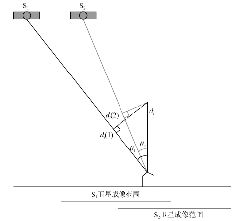
Fig.1 Subsidence monitoring from adjacent tracks.图1 相邻轨道地面沉降观测示意图 |
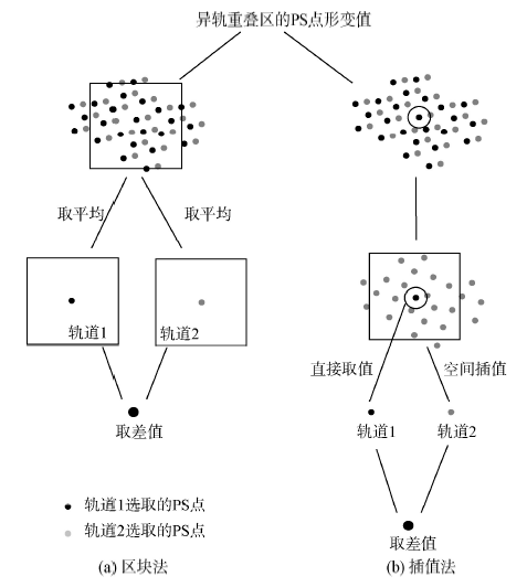
Fig.2 Block Method and Interpolation Method to calculate subsidence velocity differences between adjacent tracks.图2 像元法和插值法求重叠区域异轨形变速率差原理图 |
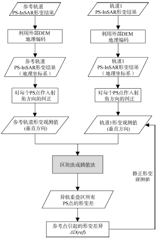
Fig.3 The processing procedure of connecting PS-InSAR subsidence velocities from adjacent tracks.图3 相邻轨道PS-InSAR沉降速率拼接处理流程图 |
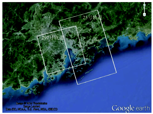
Fig.4 The coverage of research area图4 研究区域覆盖范围示意图 |
Fig.5 Temporal and perpendicular baseline distribution of ENVISAT ASAR images from track 297 and track 25.图5 297号轨道与25号轨道的ENVISAT ASAR数据时间分布与时空基线分布图 |
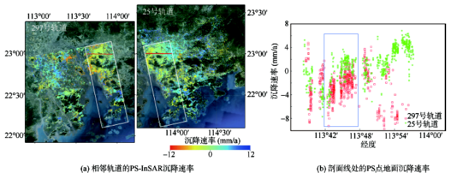
Fig.6 PS-InSAR subsidence velocities from adjacent tracks图6 相邻轨道的PS-InSAR沉降速率 |
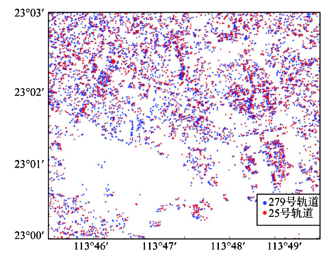
Fig.7 Distribution of PS from track 297 and track 25 (subset of overlapped area).图7 297轨道和25轨道PS点位置分布图(重叠区子区域) |
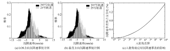
Fig.8 Statistics of subsidence velocities from two adjacent tracks and the impact of incidence difference on subsidence velocity difference.图8 重叠区域沉降速率统计图以及入射角效应对沉降速率差的影响 |
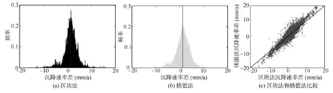
Fig.9 Comparison between Block Method and Interpolation Method.图9 区块法和插值法比较 |
Tab.1 Statistical analysis of two methods: Block Method and Interpolation Method(mm)表1 重叠区沉降速率差的统计分析(mm) |
| 方法 | 方向 | 均值 | 众数 | 最小值 | 最大值 | 标准差 |
|---|---|---|---|---|---|---|
| 区块法 | LOS方向 | 1.163 | 2.433 | -15.474 | 17.807 | 2.884 |
| 垂直方向 | 1.269 | 2.655 | -16.481 | 19.014 | 3.089 | |
| 插值法 | LOS方向 | 1.168 | 2.133 | -16.067 | 15.612 | 3.091 |
| 垂直方向 | 1.275 | 1.065 | -17.118 | 16.771 | 3.318 |
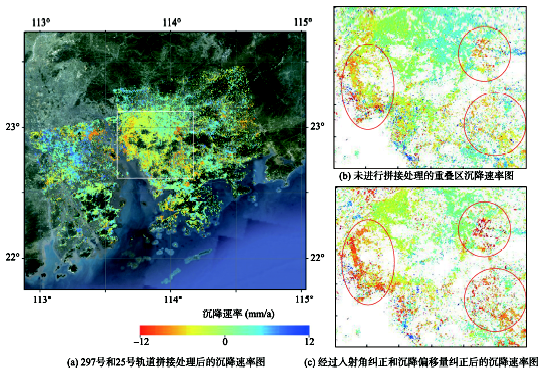
Fig.10 Subsidence velocity maps before and after the connection of track 297 and track 25图10 297号和25号轨道拼接处理前后的沉降速率图 |
The authors have declared that no competing interests exist.
| [1] |
|
| [2] |
|
| [3] |
|
| [4] |
|
| [5] |
|
| [6] |
|
| [7] |
|
| [8] |
|
| [9] |
|
| [10] |
|
| [11] |
|
| [12] |
|
| [13] |
|
| [14] |
|
| [15] |
|
| [16] |
|
/
| 〈 |
|
〉 |
