
面向对象的南海珊瑚礁地貌单元提取
作者简介:龚剑明(1975-),博士,湖北黄冈人,研究方向为遥感与地理信息系统应用。E-mail:jmgong@126.com
收稿日期: 2014-09-21
要求修回日期: 2014-10-23
网络出版日期: 2014-11-01
基金资助
国家“863”重大项目课题(2012AA12A406)
A Study on the Object-oriented Model for Geomorphic Unit Extraction of Coral Reefs in the South China Sea
Received date: 2014-09-21
Request revised date: 2014-10-23
Online published: 2014-11-01
Copyright
南海珊瑚礁地貌信息的提取是珊瑚礁资源利用、生态保护与管理及可持续发展的重要地学基础。本文提出了面向对象的珊瑚礁地貌单元提取模型,针对不同的地貌单元,以不同地貌单元的最优分割尺度、光谱参数、形状参数来分割影像并合并成不同对象,从而获得相应的地貌单元。通过大量实验得出自然地貌的最优分割尺度区间为[140,600],其中附礁生物稀疏带及丛生带、礁坑发育带的光谱参数和形状参数分别为0.9和0.1,其他自然地貌单元的光谱参数和形状参数分别为0.8和0.2;人工地貌的最优分割尺度区间为[25,170],其光谱参数和形状参数分别为0.8和0.2。进一步以南沙群岛簸箕礁WorldView-2高分辨率遥感影像为例提取地貌单元,并结合混淆矩阵和Kappa系数对分类结果进行了精度评价,地貌单元提取总体精度达到了85.75%,Kappa系数为0.8349。结果表明,该方法可有效运用南海珊瑚礁遥感影像的光谱特征、纹理特征,以及影像数据不同波段的组合特性,综合了影像和珊瑚礁地貌的关联特性,充分利用了珊瑚礁不同地貌相带的异质性,获得了理想的南海珊瑚礁地貌的整体信息,满足了我国南海珊瑚礁地貌信息提取和地貌数字产品生成的需求。
关键词: 南海; 珊瑚礁; 地貌; WorldView-2遥感影像; 面向对象
龚剑明 , 朱国强 , 杨娟 , 左秀玲 , 石伟 . 面向对象的南海珊瑚礁地貌单元提取[J]. 地球信息科学学报, 2014 , 16(6) : 997 -1004 . DOI: 10.3724/SP.J.1047.2014.00997
Geomorphology of coral reefs is the foundation for understanding the reef-building process and mechanism. It is worthwhile to acquire the geomorphological information of coral reefs in the South China Sea because this information can provide valuable insights for the resources utilization, ecological protection and management as well as sustainable development of coral reefs in China. Based on the development of current remote sensing techniques, an object-oriented geomorphic unit extraction method for coral reefs is proposed in this paper. The satellite images are segmented by the optimal scales, spectral parameters and shape parameters and the segmented objects are combined to different objects to obtain the geomorphic units. Through a large number of experiments, the optimal scales for natural geomorphic units range from 140 to 600. Spectral parameters and shape parameters for sparse reef associations zone, numerous reef associations zone, and reef pits development zone are all 0.9 and 0.1, respectively. Spectral parameters and shape parameters for other natural geomorphic units are 0.8 and 0.2, respectively. On the other hand, optimal scales for man-made geomorphic units range from 25 to 170, while their spectral parameters and shape parameters are all 0.8 and 0.2, respectively. The WorldView-2 high resolution remote sensing image of Boji Reef in Nansha Islands is used as experimental data in this paper and the accuracy of classification results is assessed with the confusion matrix and Kappa coefficient, the overall accuracy of geomorphic unit extraction reaches 85.75% and the Kappa coefficient is 0.8349. The results show that this method can effectively take advantage of the features of spectra, texture and the stacking of different wavebands of satellite images. In addition, this method can grasp the correlation of satellite image and reef geomorphic zonation and make full use of the heterogeneity of reef geomorphology. Therefore, an ideal geomorphic zonation that has a higher accuracy can be obtained to acquire geomorphological information and produce geomorphological digital products of coral reefs in the South China Sea.
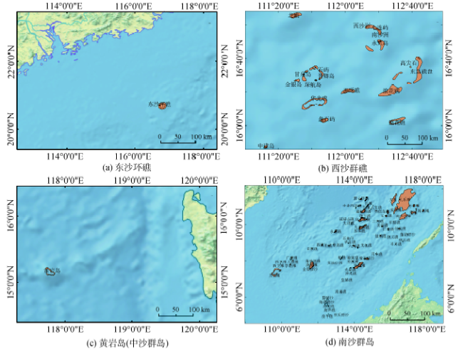
Fig. 1 Sketch map of the study region图1 研究区域的位置示意图 |
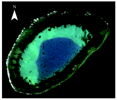
Fig. 2 Boji Reef’s satellite remote sensing image图2 簸箕礁卫星遥感影像示例 |
Fig. 3 Extraction process of coral reef geomorphic units based on objects图3 基于对象的珊瑚礁地貌单元提取流程 |
Fig. 4 Multi-scale segmentation results of reef flat (shape=0.2,compact=0.6)图4 礁坪的多尺度分割(shape=0.2,compact=0.6) |
Tab. 1 Geomorphic zonation of coral reefs in the South China Sea表1 南海珊瑚环礁地貌分类体系 |
| 一级分类体系 | 二级分类体系 | 三级分类体系 | 定义 |
|---|---|---|---|
| 自然地貌 | 水下礁脊 | 环礁外缘不出露礁坪或开放型环礁的口门处 | |
| 外礁坪 | 低潮全部干出,发育有槽沟 | ||
| 礁凸起带 | 内、外礁坪的分界 | ||
| 附礁生物稀疏带 | 紧靠凸起带内缘,但稍低于凸起带,影像呈浅色调 | ||
| 附礁生物丛生带 | 内礁坪的中部,紧连附礁生物稀疏带,影像呈深色调 | ||
| 礁坑发育带 | 内礁坪向潟湖过渡的分界,在近附礁生物丛生带呈斑块状,紧邻潟湖边缘端呈凹凸状 | ||
| 潟湖 | 潟湖坡 | 从礁坪内缘至潟湖底的斜坡带 | |
| 潟湖底 | 环礁环绕水域的中心部分 | ||
| 点礁 | 从潟湖底或边坡上显著突出的小礁体 | ||
| 潮汐通道 | 非封闭环礁潟湖水体与外海水体交换的通道 | ||
| 沙洲 | 高潮出露的生物碎屑和砂质堆积 | ||
| 灰沙岛 | 海滩 | 灰沙岛的边缘地带,属潮间带,以砂为主 | |
| 沙堤 | 紧靠海滩,向灰沙岛的内部隆起 | ||
| 沙席 | 紧靠沙堤的背风坡,呈圈状逐渐包围的砂体 | ||
| 洼地 | 灰沙岛地势最低处,一般处于岛中部 | ||
| 人工地貌 | 房屋、军事设施、浮标、码头、港池、楼堡等 |
Tab. 2 The multi-scale segmentation parameters of Boji Reef’s images表2 簸箕礁的影像分割参数 |
| 地貌类别 | 尺度参数 | 光谱因子 | 形状因子 | 形状因子 | |
|---|---|---|---|---|---|
| 紧致度 | 光滑度 | ||||
| 外礁坪 | 600 | 0.8 | 0.2 | 0.6 | 0.4 |
| 波浪破碎带 | 600 | 0.8 | 0.2 | 0.6 | 0.4 |
| 附礁生物稀疏带 | 600 | 0.9 | 0.1 | 0.6 | 0.4 |
| 附礁生物丛生带 | 600 | 0.9 | 0.1 | 0.6 | 0.4 |
| 礁坑发育带 | 300 | 0.9 | 0.1 | 0.6 | 0.4 |
| 潟湖坡 | 500 | 0.8 | 0.2 | 0.6 | 0.4 |
| 潟湖底 | 140 | 0.8 | 0.2 | 0.6 | 0.4 |
| 点礁 | 140 | 0.8 | 0.2 | 0.6 | 0.4 |
| 沙洲 | 500 | 0.8 | 0.2 | 0.6 | 0.4 |
| 防波堤 | 25 | 0.8 | 0.2 | 0.5 | 0.5 |
| 楼堡 | 170 | 0.8 | 0.2 | 0.6 | 0.4 |
| 灯塔 | 50 | 0.8 | 0.2 | 0.5 | 0.5 |
| 港池 | 150 | 0.8 | 0.2 | 0.6 | 0.4 |
Tab. 3 The classification rule set of Boji Reef表3 簸箕礁的分类规则集 |
| 地貌类别 | 特征空间 | 模糊规则 |
|---|---|---|
| 外礁坪 | Brightness | 65<Brightness<71 |
| Ratio | 0.081<Ratio<0.084 | |
| 波浪破碎带 | Mean Layer4 | 100<Mean Layer4<385 |
| 附礁生物稀疏带 | Brightness | 72<Brightness<75 |
| NDVI | NDVI>0.37 | |
| 附礁生物丛生带 | Brightness | 62<Brightness<65 |
| NDVI | NDVI>0.37 | |
| 礁坑发育带 | Mean Layer4 | 59<Mean Layer4<60 |
| 潟湖坡 | Brightness | 95<Brightness<100 |
| Mean Layer4 | 54.45<Mean Layer4<59.5 | |
| 潟湖底 | Brightness | 58<Brightness<62 |
| Mean Layer4 | 59.62<Mean Layer4<63.5 | |
| 点礁 | Brightness | 54<Brightness<58 |
| 沙洲 | Brightness | 392<Brightness<629 |
| Area | 100<Area<238 | |
| 防波堤 | Area | 861<Area<1286 |
| Mean Layer4 | 200<Mean Layer4<240 | |
| 楼堡 | Area | 76<Area<425 |
| Mean Layer4 | 376<Mean Layer4<418 | |
| 灯塔 | Area | 226<Area<343 |
| Mean Layer4 | 414.13<Mean Layer4<14.76 | |
| 港池 | Mean Layer4 | 84<Mean Layer4<95 |
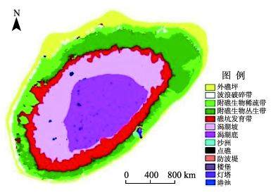
Fig. 5 The classification result based on the object-oriented method图5 基于面向对象方法的分类结果 |
Fig. 6 The classification result after post-processing图6 分类后处理的分类结果 |
Tab. 4 Accuracy evaluation of Boji Reef's geomorphological information extraction results表4 基于面向对象方法的簸箕礁地貌信息提取结果精度评价 |
| 信息类型 | 参考点数 | 分类总数 | 正确分类数 | 错分误差(%) | 漏分误差(%) | 制图精度(%) | 用户精度(%) | |
|---|---|---|---|---|---|---|---|---|
| 外礁坪 | 190 | 133 | 124 | 6.77 | 30 | 65.26 | 93.23 | |
| 波浪破碎带 | 180 | 176 | 174 | 1.14 | 3.33 | 96.67 | 98.86 | |
| 附礁生物稀疏带 | 82 | 81 | 80 | 1.23 | 2.44 | 97.56 | 98.77 | |
| 附礁生物丛生带 | 99 | 82 | 81 | 1.22 | 18.18 | 81.82 | 98.78 | |
| 礁坑发育带 | 55 | 80 | 51 | 36.25 | 7.27 | 92.73 | 63.75 | |
| 潟湖坡 | 71 | 70 | 70 | 0 | 1.41 | 98.59 | 100 | |
| 潟湖底 | 62 | 63 | 62 | 1.59 | 0 | 100 | 98.41 | |
| 点礁 | 2 | 19 | 2 | 89.47 | 0 | 100 | 10.53 | |
| 沙洲 | 3 | 6 | 2 | 66.67 | 33.33 | 66.67 | 33.33 | |
| 防波堤 | 3 | 9 | 3 | 66.67 | 0 | 100 | 33.33 | |
| 楼堡 | 4 | 4 | 3 | 25 | 25 | 75 | 75 | |
| 灯塔 | 1 | 3 | 1 | 66.67 | 0 | 100 | 66.67 | |
| 港池 | 13 | 14 | 3 | 78.57 | 76.92 | 23.08 | 21.43 | |
| 总体精度(%) | 85.75 | |||||||
| Kappa系数 | 0.8649 | |||||||
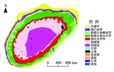
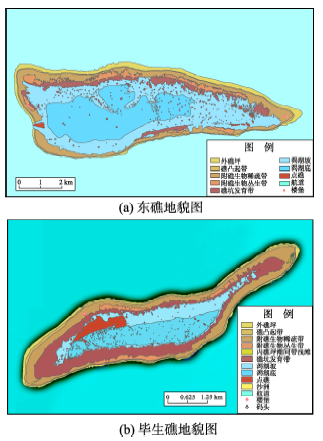
Fig. 7 The geomorphological classification maps of East Reef and Bisheng Reef图7 东礁和毕生礁地貌分类结果图 |
The authors have declared that no competing interests exist.
| [1] |
|
| [2] |
|
| [3] |
|
| [4] |
|
| [5] |
|
| [6] |
|
| [7] |
|
| [8] |
|
| [9] |
|
| [10] |
|
| [11] |
|
| [12] |
|
| [13] |
|
| [14] |
|
| [15] |
|
| [16] |
|
/
| 〈 |
|
〉 |

