
WCPS与Web传输协议的地理格网互操作耦合模型及应用研究
作者简介:余劲松弟(1984-),男,博士,副教授,研究方向为地理信息标准化、数字化对地观测、空间数据库和长期科学数据保存。E-mail:yyx350@126.com
收稿日期: 2014-04-03
要求修回日期: 2014-07-11
网络出版日期: 2015-02-10
基金资助
福建省自然科学基金计划项目(2014J05048)
国家“863”重大项目课题(2012AA12A208)
国家科技支撑计划项目(2007BAH16B00)
民用航天预研”十二五”项目
国家自然科学基金项目(41401454)
福州大学科研启动基金项目(0102510073)
Research on Geographic Grid Interoperation Model by Coupling WCPS and Web Protocols
Received date: 2014-04-03
Request revised date: 2014-07-11
Online published: 2015-02-10
Copyright
地理格网互操作增强了地理格网信息资源的融合能力,促进了地理格网信息资源的充分合理利用。然而,地理格网互操作解决方案复杂,通用Web协议没有针对具体地理格网互操作的定义,需研究通用Web协议与地理格网互操作的藕合。OGC WCPS是比较好的地理格网互操作语言规范。本研究在剖析WCPS语言主要特点基础上,归纳了标准的地理格网及其互操作的函数模型,分析了地理格网互操作Web实现的相关协议与标准规范,创造性地提出WCPS与Web传输协议的地理格网互操作耦合模型,针对地理格网分析的Web实现展开快速原型研究,结果表明,WCPS与Web应用协议的耦合可有效提高地理格网分析的互操作性,增强GIS基础设施的服务功能,为WCS Processing扩展标准的制定与更新提供了科学判据,从而为国家区域数字化建设提供支持。
余劲松弟 , 承达瑜 , 吴升 . WCPS与Web传输协议的地理格网互操作耦合模型及应用研究[J]. 地球信息科学学报, 2015 , 17(2) : 191 -196 . DOI: 10.3724/SP.J.1047.2015.00191
The explosion of available Geographic Grid resources in a wide range of Earth Science System application domains is shifting the paradigm of Earth Data Science. To exploit and acquire further insights and knowledge based on archived Geographic Grid resources, the existing infrastructures and techniques need to be scaled up and scaled out. However, adding more nodes does not provide a real analytics capability improvement if it is implemented without a corresponding analytics service interfaces among these nodes. The development of standard-based online analytics services is considered as one of the potential solutions and is becoming indispensable to strengthen mutual integration between Geographic Grid information systems and other information systems. In this study, standard-based Geographic Grid models and analytics operations are reviewed and discussed by considering different web communication protocols, making it possible to explore different modular coupling and application profiling. Based on the probe of OGC Web Coverage Processing Language (WCPS) specifications and relevant Web Coverage Service (WCS) 2.0 core and extension specifications, a web interoperability study is carried out to prototype an interoperable Geographical Grid analytics service. Accordingly, the research concludes the coupling patterns, principle issues and application directions for future explorations on Geographical Grid Analytics web applications. The result shows that the coupling of WCPS and OGC WCS 2.0 can effectively improve the interoperability of Geographical Information Application Infrastructure in terms of Earth Science System monitoring and forecasting, so as to provide an effective support to National Digital Information Infrastructure Initiatives.
Key words: WCPS; geographic grid; interoperability
Tab. 1 Geographic grid operation functions with different I/O表1 不同I/O的地理格网操作函数 |
| 函数 | 输入 | 输出 | 说明 |
|---|---|---|---|
| g: <f1, f2, …fm,C1,C2,…Cn>→fr | fi : Di→Vi (i≥0), cj(j≥0), i+j≥1 | fr : Dr→Vr | 输入为格网和/或常数,输出为格网 |
| g: <f1, f2, …fm,C1,C2,…Cn>→C | fi : Di→Vi (i≥0), cj(j≥0), i+j≥1 | C | 输入为格网和/或常数,输出为常数 |
| 令fi : Di→Vi为原格网,Cj为输入常数,g为操作函数,输出常数为C,输出格网为fr : Dr→Vr | |||
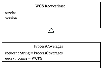
Fig. 1 ProcessCoverages service framework图1 ProcessCoverages服务框架 |
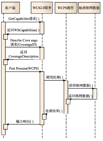
Fig. 2 ProcessCoverages service based on WCS 2.0图2 基于WCS2.0的ProcessCoverages服务 |
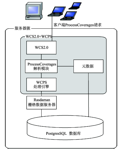
Fig. 3 Coupling model of geographic grid interoperation based on WCPS and WCS 2.0图3 基于WCPS与WCS 2.0 的地理格网互操作耦合模型 |
Tab. 2 WCS 2.0 Implementations表2 WCS 2.0实现对比 |
| 软件 | 公司/组织 | 是否开源 | WCS2.0 | KVP | POST | SOAP | WCPS |
|---|---|---|---|---|---|---|---|
| Rasdaman 9.0 | Rasdaman | 是 | 完全一致 | 是 | 是 | 是 | 是 |
| MapServer 6.0 | OSGeo - MapServer Project | 是 | 部分一致 | 是 | 是 | 否 | 否 |
| MapServer 6.2 | OSGeo - MapServer Project | 是 | 部分一致 | 是 | 是 | 否 | 否 |
| EOXServer 0.2 | EOX IT Services GmbH | 是 | 部分一致 | 是 | 是 | 否 | 否 |
| EOXServer 0.3 | Rasdaman GmbH | 是 | 部分一致 | 是 | 是 | 否 | 否 |
| OPS GIS 2.1.0 | RSI SOFTECH INDIA PVT LTD | 否 | 部分一致 | 否 | 否 | 否 | 否 |
注:以上比较数据(截止至2014年7月10日)来自http://www.opengeospatial.org/resource/products/byspec |
Fig.4 Fast Web service prototype based on Rasdaman图4 基于Rasdaman的Web服务快速原型系统图 |
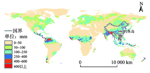
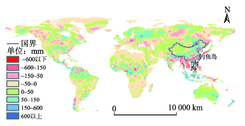
Fig. 5 Global precipitation map in July 1998图5 全球1998年7月降水量分布图 |
Fig. 6 Global precipitation differences between July 1997 and July 1998图6 全球1998年7月与1997年7月降水量差异分布图 |
The authors have declared that no competing interests exist.
| [1] |
|
| [2] |
|
| [3] |
|
| [4] |
|
| [5] |
|
| [6] |
|
| [7] |
|
| [8] |
|
| [9] |
|
| [10] |
|
| [11] |
|
| [12] |
|
| [13] |
|
| [14] |
|
| [15] |
|
| [16] |
|
| [17] |
|
| [18] |
|
| [19] |
|
| [20] |
|
| [21] |
|
| [22] |
|
| [23] |
|
| [24] |
|
| [25] |
|
| [26] |
|
/
| 〈 |
|
〉 |
