
天绘一号卫星影像的平原绿化提取方法
作者简介:尚 珂(1988-),女,硕士生,研究方向为资源环境遥感。E-mail:shang_ke@sina.cn
收稿日期: 2014-07-09
要求修回日期: 2014-09-10
网络出版日期: 2015-03-10
基金资助
中国科学院战略性先导科技专项“应对气候变化的碳收支认证及相关问题”(XDA05050102)
Study on Plain Afforestation Area Extraction with Mapping Satellite-1 Imagery
Received date: 2014-07-09
Request revised date: 2014-09-10
Online published: 2015-03-10
Copyright
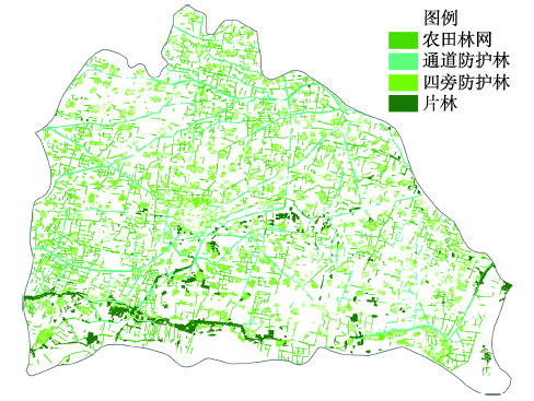
平原绿化是我国平原地区森林植被的主体,为生态环境建设提供了有力保障。但平原绿化分布零散,斑块面积小,不易被准确提取。本文以河南省封丘县为例,利用天绘一号卫星影像面向对象分类技术提取了平原绿化。在面向对象分类过程中,针对不同平原绿化信息选取不同的分割尺度和参数,建立影像对象的分割层次结构,确保农田林网、通道防护林、四旁防护林等平原绿化信息能够被准确分割。分类时通过构建隶属度函数,利用层与层之间的关系,子类继承父类的分类特征,在此基础上增加自己的特征,建立分类规则集,逐层提取绿化信息。本文共获取封丘县平原绿化面积152.51 km2,其中,农田林网36.09 km2,通道防护林21.29 km2,四旁防护林71.56 km2,片林23.57 km2。利用验证点数据,对分类结果进行精度评价,总体分类精度为93.50%,Kappa系数达到0.92。
尚珂 , 于信芳 , 岳彩荣 , 王乾坤 , 王正兴 . 天绘一号卫星影像的平原绿化提取方法[J]. 地球信息科学学报, 2015 , 17(3) : 361 -368 . DOI: 10.3724/SP.J.1047.2015.00361
Plain afforestation refers to the non-crop vegetation in crop-dominated plain area. As the main forest vegetation it has provided favorable conditions for ecological environment construction. The plain afforestation in this paper mainly includes farmland shelterbelt, road shelterbelt, residence shelterbelt and wasteland shelterbelt. But due to their small patches, getting the information of plain afforestation requires high spatial resolution remote sensing imagery. And the different sizes of kinds of afforestation patches make it difficult to extract all of them at once. In addition, it is a problem, if they could be extracted all, to distinguish themselves from one another. Based on this point, the paper explores a more accurate object-oriented classification method based on Mapping Satellite-1 (MS1) imagery in Fengqiu County, Henan province, China. The innovation of this method lies in the selection of proper segmentation scale according to different kinds of plain afforestation. Build optimal segmentation levels to insure the farmland shelterbelt, road shelterbelt, residence shelterbelt and wasteland shelterbelt could be segmented from their background imagery completely. Then contrast and analyze the spectral and spatial characteristics of different afforestation to develop classification rule sets. The classification rule sets could be conveyed between levels and current class could inherit them from parent class. Then build membership function to extract the plain afforestation area hierarchically. The results showed that the plain afforestation area of Fengqiu is 152.51 km2. More specifically, the farmland shelterbelt area is 36.09 km2, the road shelterbelt area is 21.29 km2, the residence shelterbelt area is 71.56 km2, and the wasteland shelterbelt area is 23.57 km2. The classification accuracy is 93.50% and the Kappa coefficient is 0.92. It showed that the study have achieved fine classification results. And the results also verified the potential of object-oriented plain afforestation information extraction based on Mapping Satellite-1 (MS1) imagery. This method can provide a technical support for the area accurate estimation of plain afforestadion.
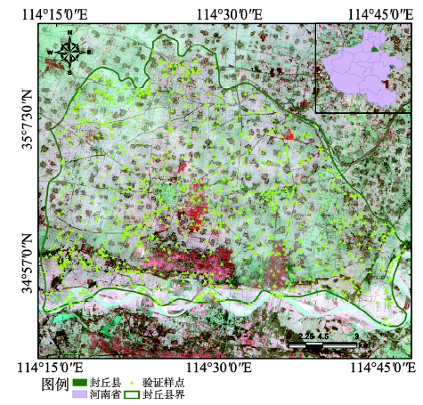
Fig. 1 The location of the study area and Mapping Satellite-1 false color composite image with the validation samples图1 研究区位置与天绘一号卫星假彩色合成影像及验证样点分布 |
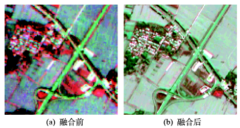
Fig. 2 The comparison of imagery before and after image fusion图2 融合前后影像假彩色对比 |
Tab. 1 Land cover classification system表1 土地覆盖分类系统 |
| 一级类型 | 二级类型 | 指标描述 |
|---|---|---|
| 林地 | 农田林网 | 指农田中由互相垂直的林带构成的网状防护林 |
| 通道防护林 | 指高速公路、国道、县乡级道路,以及河流两侧的防护林带 | |
| 四旁防护林 | 指村镇周围、居民房屋周围等,采取乔、灌相结合营造的防护林 | |
| 片林 | 指荒沙、荒滩、荒地上的连片防护林 | |
| 耕地 | 指种植农作物的土地,包括熟耕地、新开荒地、轮歇地等 | |
| 水域湿地 | 指天然陆地水域和水利设施用地 | |
| 人工表面 | 指城乡居民点、工矿、交通等用地 | |
| 其他(裸土) | 指地表土质覆盖,植被覆盖度在5%以下的土地 |
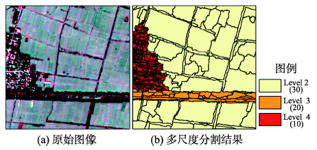
Tab. 2 Scale parameters of image segmentation表2 多尺度分割参数设置 |
| 分割等级 | 分割尺度 | 颜色 | 形状 | 光滑度 | 紧凑度 | 分割类型 | 提取类别 |
|---|---|---|---|---|---|---|---|
| Level 1 | 40 | 0.9 | 0.1 | 0.7 | 0.3 | 整体分割 | 一级类型 |
| Level 2 | 30 | 0.9 | 0.1 | 0.7 | 0.3 | 类内分割 | 农田林网 |
| Level 3 | 20 | 0.9 | 0.1 | 0.7 | 0.3 | 类内分割 | 通道防护林 |
| Level 4 | 10 | 0.9 | 0.1 | 0.7 | 0.3 | 类内分割 | 四旁防护林 |
Fig. 3 The segmentation results with different scales图3 多尺度分割结果 |
Tab. 3 Classification features表3 分类特征 |
| 特征类型 | 分类特征 | 说明 | 计算公式 |
|---|---|---|---|
| 光谱特征 | NDVI | 归一化植被指数,反映植被的生长状态和类型 | (1) |
| NDWI | 归一化水体指数,用于提取水体信息 | (2) | |
| 空间特征 | 亮度(Brightness) | 影像对象图层平均值的总和除以图层数量 | (3) |
| 密度(Density) | 反映影像对象的紧致程度,其值越大影像对象的形状越接近正方形 | (4) | |
| 边界指数(borderIndex) | 影像对象包含的像元边界总和,一个像元边界为1 | (5) |
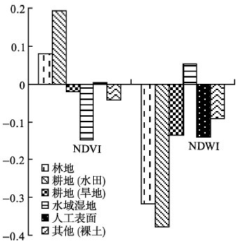
Tab. 4 Statistics of spectral feature表4 光谱特征均值统计 |
| 地类名称 | NIR | RED | GREEN | NDVI | NDWI |
|---|---|---|---|---|---|
| 林地 | 13.32 | 11.32 | 6.92 | 0.081 | -0.316 |
| 耕地(水田) | 15.90 | 10.76 | 7.17 | 0.193 | -0.378 |
| 耕地(旱地) | 19.81 | 20.67 | 15.06 | -0.021 | -0.136 |
| 水域湿地 | 17.84 | 24.06 | 19.81 | -0.148 | 0.052 |
| 人工表面 | 23.38 | 23.15 | 17.63 | 0.005 | -0.140 |
| 其他(裸土) | 20.11 | 21.89 | 16.73 | -0.042 | -0.092 |
Fig. 4 Statistics of NDVI and NDWI图4 NDVI、NDWI柱状图 |
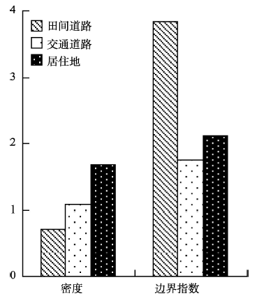
Tab. 5 Statistics of spatial feature表5 空间特征统计 |
| 地类名称 | 亮度 | 密度 | 边界指数 |
|---|---|---|---|
| 田间道路 | 15.54 | 0.72 | 3.83 |
| 交通道路 | 13.06 | 1.07 | 1.75 |
| 居住地 | 13.73 | 1.67 | 2.11 |
Fig. 5 Statistics of density and border index图5 密度、边界指数柱状图 |
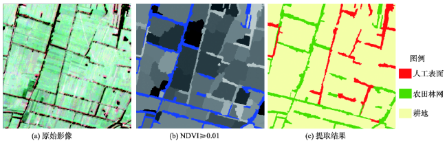
Fig. 6 Extraction of farmland shelterbelt图6 农田林网提取 |
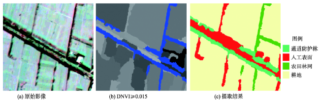
Fig. 7 Extraction of road shelterbelt图7 通道防护林提取 |
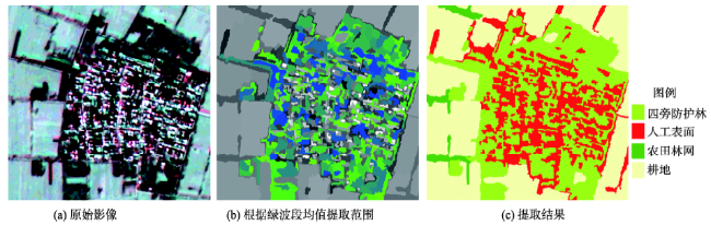
Fig. 8 Extraction of residence shelterbelt图8 四旁树提取 |
Fig. 9 Extraction result of plain afforestation图9 平原绿化提取结果 |
Tab. 6 The confusion matrix for accuracy assessment of the object-oriented classification results表6 面向对象分类结果混淆矩阵 |
| 类型 | 农田林网 | 通道防护林 | 四旁防护林 | 片林 | 耕地 | 水域湿地 | 人工表面 | 其他(裸土) | 总计 | |
|---|---|---|---|---|---|---|---|---|---|---|
| 农田林网 | 155 | 1 | 0 | 0 | 5 | 0 | 1 | 0 | 162 | |
| 通道防护林 | 0 | 188 | 0 | 2 | 0 | 1 | 9 | 0 | 200 | |
| 四旁防护林 | 0 | 0 | 265 | 3 | 0 | 0 | 11 | 0 | 279 | |
| 片林 | 3 | 4 | 4 | 154 | 2 | 0 | 1 | 0 | 168 | |
| 耕地 | 2 | 0 | 3 | 0 | 108 | 0 | 1 | 0 | 114 | |
| 水域湿地 | 0 | 1 | 0 | 1 | 0 | 47 | 0 | 8 | 57 | |
| 人工表面 | 1 | 1 | 4 | 0 | 0 | 0 | 73 | 0 | 79 | |
| 其他(裸土) | 0 | 0 | 0 | 0 | 1 | 0 | 0 | 17 | 18 | |
| 生产者精度(%) | 96.27 | 96.41 | 96.01 | 96.25 | 93.10 | 97.92 | 76.04 | 68.00 | ||
| 用户精度(%) | 95.68 | 94.00 | 94.98 | 91.67 | 94.74 | 82.46 | 92.41 | 94.44 | ||
| 总体精度(%) | 93.50 | |||||||||
| Kappa系数 | 0.92 |
The authors have declared that no competing interests exist.
| [1] |
|
| [2] |
|
| [3] |
|
| [4] |
|
| [5] |
|
| [6] |
|
| [7] |
|
| [8] |
|
| [9] |
|
| [10] |
|
| [11] |
|
| [12] |
|
| [13] |
|
| [14] |
|
| [15] |
|
| [16] |
|
| [17] |
|
| [18] |
|
| [19] |
|
| [20] |
|
| [21] |
|
| [22] |
|
| [23] |
|
| [24] |
|
| [25] |
|
| [26] |
|
| [27] |
|
| [28] |
|
| [29] |
|
| [30] |
|
| [31] |
|
/
| 〈 |
|
〉 |