
基于SGOG瓦块的数字地球真三维可视化技术与应用
作者简介:王金鑫(1968-),男,副教授,主要从事空间信息网格及3S理论与应用研究。E-mail:hnwjx2008@qq.com
收稿日期: 2014-08-07
要求修回日期: 2014-11-30
网络出版日期: 2015-04-10
基金资助
测绘遥感信息工程国家重点实验室开放基金项目(12I02)
矿山空间信息技术国家测绘地理信息局重点实验室开放基金项目(KLM201203)
郑州大学研究生教育专项基金项目(ZYJ2014050)
郑州大学大学生创新实验项目(2014xjxm056)
True 3D Global Visualization Technology Based on SGOG Bricks and Its Application
Received date: 2014-08-07
Request revised date: 2014-11-30
Online published: 2015-04-10
Copyright
以Google Earth为代表的第一代数字地球平台,利用球面剖分瓦片,构建了2.5维静态的数字地球表面,实现了地表空间数据的集成、建模和应用,但没有涉及地表上下的空间。本文阐述了球体大圆弧QTM八叉树剖分的规则、瓦块体系的几何特征及其编码原理,设计并实现了瓦块编码到空间直角坐标之间的互换算法,并利用C++和OSG等主流语言,构建了真三维数字地球可视化平台的雏形框架;实现了球面和球体的任意剖分、地表上下空间实体的可视化建模及简单三维空间分析。初步展示了球体瓦块的新一代数字平台在天地一体化空间大数据集成、管理、建模与应用中的优势及前景。研究表明,球体大圆弧QTM八叉树网格,具有简单、规整、几何特征明晰、适宜作为全球离散空间的坐标基准,利于空间实体建模与可视化等特点,可作为构建新一代数字地球平台的数据模型基础。
关键词: 数字地球; 全球离散网格; 全球空间网格; 球体大圆弧QTM八叉树网格; 可视化
王金鑫 , 李耀辉 , 郑亚圣 , 邹煚 , 杨晶 . 基于SGOG瓦块的数字地球真三维可视化技术与应用[J]. 地球信息科学学报, 2015 , 17(4) : 438 -444 . DOI: 10.3724/SP.J.1047.2015.00438
3D visualization is a key supporting technology of modern geographic information science. The spherical surface subdivision bricks were employed to build 2.5D static digital earth surface in the first generation of Digital Earth platforms represented by Google Earth. These platforms implemented earth surface data integration, model developments and applications, but did not involve the spaces above the surface and subsurface spaces. Therefore, the study of true 3D visualization technology based on spherical solid subdivision bricks is essential and necessary. The subdivision rules of Sphere Geodesic QTM Octree Grid, the geometric features, and the coding principle of brick system were described in this research. The transition algorithm between a brick code and its 3D Cartesian coordinate were designed and conducted. A prototype framework of true 3D digital earth visualization platform under C++ and OSG language environment was developed to achieve the arbitrary subdivision of a sphere, the visual modeling of underground, the surface and aerial entities, and the simple 3D spatial analysis. The advantages and prospect of the new generation Digital Earth platform in integration, management, model development and application of integrated space-ground spatial big data were demonstrated. The results indicate that the Sphere Geodesic Octree Grid has advantages such as simplicity, regularity, clear geometric features, being suitable as a global discrete space datum, and being conducive to the spatial entity modeling and visualization, etc. It can be used as the basis of data model to develop a new generation of Digital Earth platform.
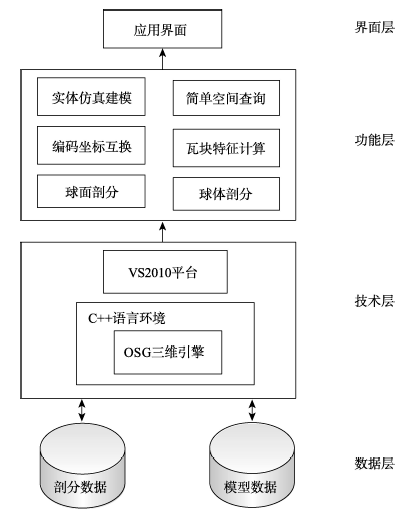
Fig. 1 The system architecture图1 系统总体技术架构 |
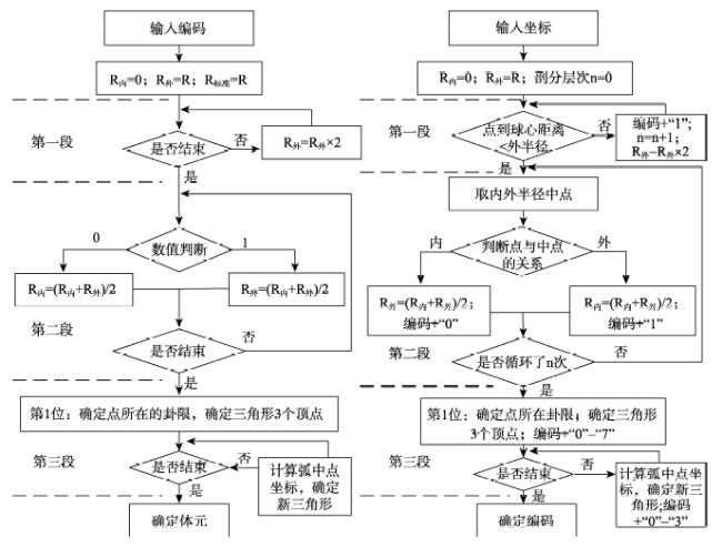
Fig. 2 Conversion algorithm between octree code and 3D coordinates图2 八叉树编码到空间直角坐标映射的算法思路 |
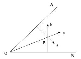
Fig. 3 Method for judging a point location图3 空间点位置的判断方法 |
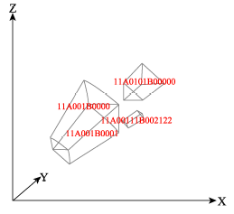
Fig. 4 Voxel bricks and their codes图4 体元瓦块及其编码示意图 |
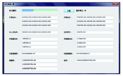
Fig. 5 Geometric characteristic values of a voxel brick图5 体元瓦块的几何特征值计算 |
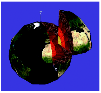
Fig. 6 Arbitrarily divided of true three-dimensional Digital Earth based on voxel bricks图6 真三维数字地球的分割 |
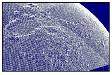
Fig. 7 Large area DEM visualization图7 大区域DEM可视化效果 |
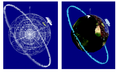
Fig. 8 The integrative geographic entity modeling图8 天地一体化地理实体建模 |
The authors have declared that no competing interests exist.
| [1] |
|
| [2] |
|
| [3] |
|
| [4] |
|
| [5] |
|
| [6] |
|
| [7] |
|
| [8] |
|
| [9] |
|
| [10] |
|
| [11] |
|
| [12] |
|
| [13] |
|
| [14] |
|
| [15] |
|
| [16] |
|
| [17] |
|
| [18] |
|
| [19] |
|
| [20] |
|
| [21] |
|
| [22] |
|
| [23] |
|
| [24] |
|
| [25] |
|
| [26] |
|
/
| 〈 |
|
〉 |