
广州城市暴雨内涝时空演变及建设用地扩张的影响
作者简介:李彬烨(1991-),男,广东汕尾人,硕士生,主要从事地理模拟与公共政策研究。E-mail:libinye1991@hotmail.com
收稿日期: 2014-11-14
要求修回日期: 2015-01-26
网络出版日期: 2015-04-10
基金资助
国家自然科学基金项目(41101152)
“973”计划前期研究专项(2014CB460614)
广州市产学研协同创新重大专项民生科技项目(156100021)
“十二五”国家科技支撑计划课题(2012BAJ22B06)
教育部留学回国人员科研启动基金资助项目(2012-940)
Spatio-temporal Characteristics of Urban Storm Waterlogging in Guangzhou and the Impact of Urban Growth
Received date: 2014-11-14
Request revised date: 2015-01-26
Online published: 2015-04-10
Copyright
暴雨内涝是城市常见的“城市病”。本研究通过收集20世纪80年代、90年代,以及2000年之后广州市主城区严重暴雨内涝资料,探索改革开放后广州市暴雨内涝时空演变特征,分析城市建设用地扩张对暴雨内涝的影响。结果表明,20世纪80年代至今,广州市主城区暴雨内涝点在时间和空间2个尺度上有显著的变化。早期内涝点主要集中于市中心的越秀区,随着城市化进程的推进逐渐在白云、天河等城市化较快的区域出现。从1990-2010年,广州市城乡建设用地扩张显著,城市不透水面密度与暴雨内涝点核密度呈正相关。其相关性随城市化发展逐渐增强,表明改革开放后广州市城市的快速扩张,对主城区暴雨内涝点的时空演变有较大的影响。因此,城市暴雨内涝的防治应重视城市不透水面格局的优化和调整。
李彬烨 , 赵耀龙 , 付迎春 . 广州城市暴雨内涝时空演变及建设用地扩张的影响[J]. 地球信息科学学报, 2015 , 17(4) : 445 -450 . DOI: 10.3724/SP.J.1047.2015.00445
Urban storm waterlogging has become one of the common serious “urban diseases” in China. The purpose of this study is to examine the spatio-temporal characteristics of urban storm waterlogging in Guangzhou from the 1980s and analyze the relationship of urban storm waterlogging and urban growth. Information about the urban storm waterlogging in Guangzhou was gathered from the newspaper of Guangzhou Daily and from the waterlogging census implemented by Guangzhou Bereau of Water affairs. Moreover, Landsat TM/ETM 30 m images for the years of 1990, 1999, and 2010 were collected to monitor the urban growth of Guangzhou. Density estimation method was used to quantify the density of these waterlogging spots and calculate the construction land ratio of Guangzhou. The relationship of urban storm waterlogging with urban growth was explored using Pearson correlation coefficient. The results show that the urban storm waterlogging spots in Guangzhou had increased greatly on the time scale and had sprawled since the 1980s on the spatial scale. In the 1980s, waterlogging disaster mostly took place in Yuexiu district, which is the core area of Guangzhou. However, the disaster had gradually spread into districts that having rapid urban growth such as Baiyun and Tianhe after the 1990s. Simultaneously, the urban area also had sprawled rapidly from 1990 to 1999 and to 2010. According to the results of Pearson correlation coefficient calculation, the density of waterlogging spots is positively correlated with the construction land ratio, and the correlation relationship gradually strengthens with respect to the rapid urbanization, implying the notable impact of construction land ration on urban storm waterlogging. The results suggest that more attention should be paid to the optimization of construction land ratio in urban planning procedure, and the government should improve the condition of drainage pipeline system and facilities to avoid urban storm waterlogging.
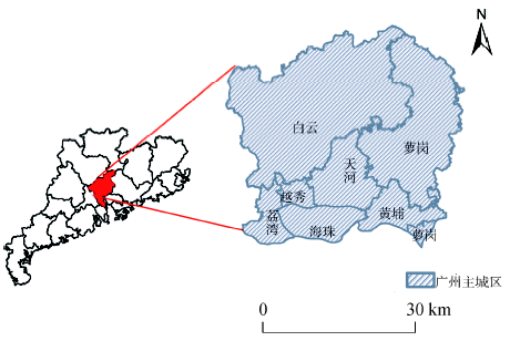
Fig. 1 Study Area图1 研究区地理位置与分布 |
Tab. 1 Data sources and relevant information表1 数据及相关信息 |
| 数据名称 | 格式 | 时间(年) | 数据来源 |
|---|---|---|---|
| 1:400万行政区划 | Esri shapefile | 2005 | 国家基础地理信息系统网站 |
| Landsat遥感影像 | Img | 1990-11-03 1999-11-15 2010-10-28 | USGS |
| 高分辨率遥感影像 | Jpeg | 2000 2008 2010 | Google Earth 航片 |
| 暴雨内涝信息 | 文本资料 | 1980-2012 | 广州市水务局 《广州日报》 |
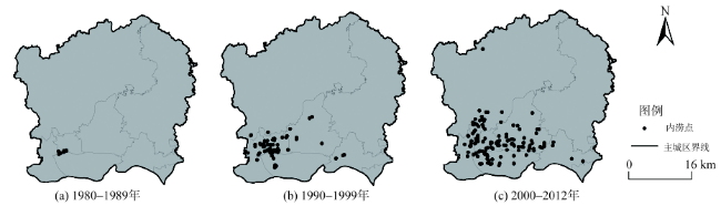
Fig. 2 Spatial distribution of urban storm waterlogging in the main districts of Guangzhou from 1980 to 2012图2 1980-2012年广州市主城区城市暴雨内涝事件点空间分布 |
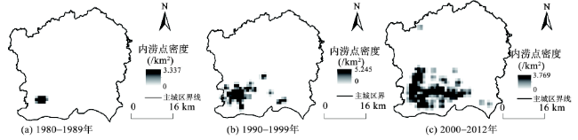
Fig. 3 Kernel density of urban storm waterlogging in the main districts of Guangzhou from 1980 to 2012图3 1980-2012年广州市主城区暴雨内涝事件核密度 |
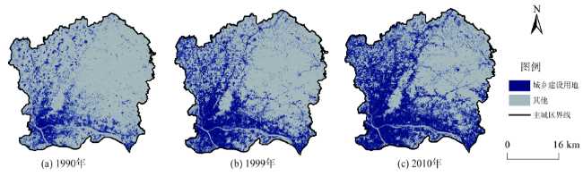
Fig. 4 Changes of construction land from 1990-2010 in the main districts of Guangzhou图4 1990-2010年广州市主城区城乡建设用地变化 |
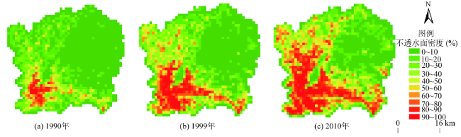
Fig. 5 Changes of imperviousness density from 1990-2010 in the main districts of Guangzhou图5 1990-2010年广州市主城区不透水面密度变化 |
Tab. 2 The Pearson correlation coefficients between waterlogging density and imperviousness density表2 内涝点核密度与不透水面密度的皮尔森相关系数 |
| 时期 | 皮尔森相关系数 | 显著性(双尾) |
|---|---|---|
| 20世纪80年代 | 0.214 | 0.01 |
| 20世纪90年代 | 0.317 | 0.01 |
| 2000年以后 | 0.429 | 0.01 |
The authors have declared that no competing interests exist.
| [1] |
|
| [2] |
|
| [3] |
|
| [4] |
|
| [5] |
|
| [6] |
|
| [7] |
|
| [8] |
|
| [9] |
|
| [10] |
|
| [11] |
|
| [12] |
|
| [13] |
|
| [14] |
|
| [15] |
|
| [16] |
|
| [17] |
|
| [18] |
|
| [19] |
|
| [20] |
|
| [21] |
|
| [22] |
|
| [23] |
|
| [24] |
|
| [25] |
|
| [26] |
|
| [27] |
|
| [28] |
|
| [29] |
|
| [30] |
|
| [31] |
|
| [32] |
|
/
| 〈 |
|
〉 |