
基于GeoSOT-3D的空间对象快速可视化与实验分析
作者简介:李志强(1990-),男,博士生,研究方向为空间信息组织理论与方法。E-mail: geosciencer@pku.edu.cn
收稿日期: 2014-12-29
要求修回日期: 2015-05-21
网络出版日期: 2015-07-08
基金资助
国家高分辨率对地观测系统重大专项(30-Y30B13-9003-14/16, 03-Y30B06-9001-13/15)
Research on Spatial Objects Fast Visualization Based on GeoSOT-3D
Received date: 2014-12-29
Request revised date: 2015-05-21
Online published: 2015-07-08
Copyright
地球空间信息剖分组织,在全球海量、多源、多分辨率数据组织与管理方面表现出了极大的优越性。但全球尺度的空间数据往往数据量大、内容丰富,进行对象表达时需处理的数据量,远远超出计算机硬件的处理能力。鉴此,本文在GeoSOT-3D地球空间剖分框架下,借鉴已有三维快速可视化技术,并顾及GeoSOT-3D自身的全球多尺度划分、无缝无叠、二进制一维整形编码等特性,将现有三维快速可视化方法与GeoSOT-3D剖分框架特性相结合,提出了八叉树索引的空间对象裁剪和消隐策略,实现了GeoSOT-3D框架下空间对象的快速剖分表达。同时,以空间电磁场的表达为例,开发了试验系统,并对结果进行了分析,解决了GeoSOT-3D空间对象表达效率低下的问题。
李志强 , 程承旗 , 李爽 . 基于GeoSOT-3D的空间对象快速可视化与实验分析[J]. 地球信息科学学报, 2015 , 17(7) : 810 -815 . DOI: 10.3724/SP.J.1047.2015.00810
Earth observation technology has developed rapidly nowadays, accumulating a great amount of data for studying earth system science and other global issues. But when facing the massive, multi-source and multi-resolution global data, how could it be rationally organized and managed to improve the efficiency of data analysis has become a challange. The geospatial information subdivision organization, as a new organizational idea of spatial information, is regarded as a potential solution. Among various domestic and international geospatial information subdivision organization frameworks, the GeoSOT-3D subdivision framework, proposed by the team of Professor Cheng Chengqi from Peking University, has obtained extensive close attention. Nevertheless, the spatial data at global scale are often massive and rich in content, resulting in a contradiction that the amount of data to be processed is far beyond the processing ability of the computer when expressing geospatial objects. To solve this problem, this paper combines the geospatial information subdivision model with the existing 3D rapid visualization technology, and proposes a clipping and hidden face removal strategy assisted by the octree to achieve the rapid subdivision expression of geospatial objects based on the GeoSOT-3D. Taking the expression of space electromagnetic field for example, we developed a demo system and discussed the simulation results. The simulation results demonstrate that the proposed method exhibited a better effect and to some extent resolved the issue of efficiency in the expression of spatial objects.
Key words: subdivision; GeoSOT; expression; 3D visualization; octree
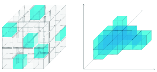
Fig. 1 The subdivision modeling of 3D spatial object图1 三维空间对象的剖分建模 |
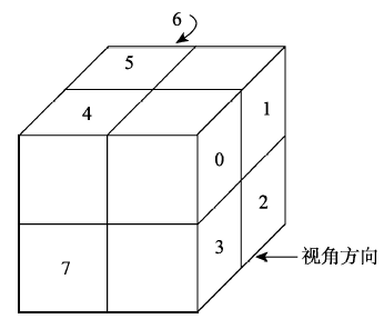
Fig. 2 The node structure of octree图2 八叉树结点示意 |
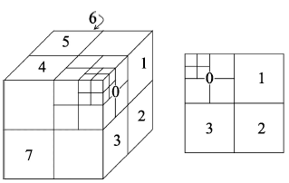
Fig. 3 Observe the octree from a particular direction图3 从特定方向观察八叉树 |
Fig. 4 Map the octree to the quadtree图4 将八叉树映射到四叉树 |
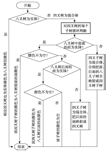
Fig. 5 The algorithm of transforming octree to the corresponding quadtree图5 空间八叉树向相应平面四叉树转换算法流程 |
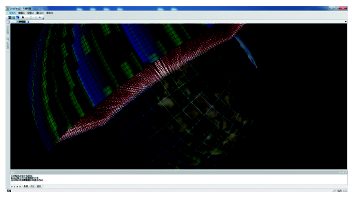
Fig. 6 The visualization expression of space electromagnetic field图6 空间电磁场可视化表达 |
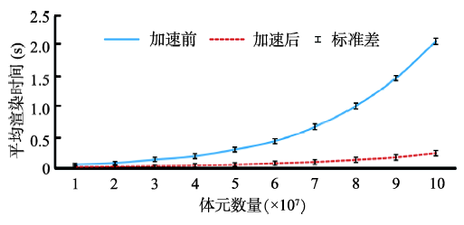
Fig. 7 The comparison of time before and after acceleration图7 加速前后耗费时间比较 |
The authors have declared that no competing interests exist.
| [1] |
|
| [2] |
|
| [3] |
|
| [4] |
|
| [5] |
|
| [6] |
|
| [7] |
|
| [8] |
|
| [9] |
|
| [10] |
|
| [11] |
|
| [12] |
|
| [13] |
|
| [14] |
|
| [15] |
|
| [16] |
|
| [17] |
|
| [18] |
|
| [19] |
|
| [20] |
|
/
| 〈 |
|
〉 |