
新疆吐鲁番地区土遗址及其环境变化空间信息分析
作者简介:江红南(1980-),男,讲师,研究方向为摄影测量与遥感。E-mail: jiang_hn@126.com
收稿日期: 2014-09-22
要求修回日期: 2015-01-05
网络出版日期: 2015-08-05
基金资助
国家社会科学研究基金项目(10XKG0006)
吐鲁番学研究院课题(TX2012-017)
Analysis of Spatial-Temporal Change of Earthen Sites and Their Environment Based on Spatial Information Technology in Turpan Region, Xinjiang
Received date: 2014-09-22
Request revised date: 2015-01-05
Online published: 2015-08-05
Copyright
新疆吐鲁番地区的土遗址数量较多,且具有重要历史文化价值,故对土遗址及其环境的时空变化研究具有重要意义。目前,对大型土遗址的发现保护多利用考古、实地调查和空间信息技术等方法。鉴此,本文分析了吐鲁番地区土遗址及其内外部环境的变化。研究结果表明,20世纪60年代至2010年间该区域土遗址本体及其内部环境发生了较大变化,其主要影响因素是病害发育和人为破坏。病害主要为裂隙与坍塌、风害、酥碱病害、水蚀、表层剥落、生物病害等,其中,普遍的病害是裂隙与坍塌和风害。1990-2010年,研究区土遗址外部地表环境发生了较大变化,耕地和居民地明显增加,草地和未利用地明显减少,尤其是交河故城和高昌故城这2个世界文化遗产区域发生的变化更明显。土遗址周围的人类活动强度在增加,绿洲内部土遗址的外部环境较绿洲边缘或外部更加剧烈;内部的土遗址更容易受到人类活动的影响,而外部环境变化的主要影响因素是人类的耕地和居民地开发活动。
江红南 , 张永兵 , 徐佑成 , 孟优 . 新疆吐鲁番地区土遗址及其环境变化空间信息分析[J]. 地球信息科学学报, 2015 , 17(8) : 963 -968 . DOI: 10.3724/SP.J.1047.2015.00963
There are a large number of earthen sites that have important historical and cultural values in Turpan region, Xinjiang. It is very meaningful to study the spatial-temporal change of earthen sites and their environment. Aiming at the exploration of earthen sites conservation, using methods of archaeology and field investigation, remote sensing (RS), geographic information system (GIS), and global positioning system (GPS) techniques, we analyzed the spatial-temporal change of earthen sites and their internal-external environment. The results showed that the persistence of the earthen sites has a close relationship with the regional environment, that the regional environment has an influence on the persistence of earthen sites. The earthen sites and their internal environment had changed greatly from the 1960s to 2010. We found that the main driving forces of earthen sites and their internal environment change were diseases and human destructions. The main forms of diseases in earthen sites are fracture and collapse, wind erosion, water erosion, alkali disease, surface peeling, and biological erosion. Among the above factors, fracture, collapse and wind erosion are the dominant forms. From 1990 to 2010, great changes in the external environment of earthen sites had taken place in the study area. The cultivated land and residential land had increased significantly, while the grassland and unused land had decreased obviously. The changes in the external environment were especially obvious around Jiaohe and Gaochang ruins, while the intensity of human activities around these earthen sites had increased. The changes in surface environment types of earthen sites in different regions were different. The changes in environment types of earthen sites that located in the interior of oasis were more intense than those located at the edge of oasis; earthen sites that located in the interior of oasis are more vulnerable to the impacts of human activities. The development of cultivated land and residential land were the main driving forces of the external environment change of earthen sites, thus it is necessary to limit human activities for the purpose of earthen sites conservation.
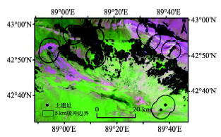
Fig. 1 Regional division of earthen sites in Turpan图1 吐鲁番地区土遗址区域划分示意图 |
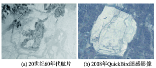
Fig. 2 Remote sensing images of Gaochang ruins图2 高昌故城遥感影像 |
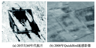
Fig. 3 Remote sensing images of Kuotantur ruins图3 阔坦吐尔古城遥感影像 |
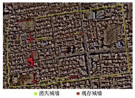
Fig. 4 Change of Liuzhong ruins from the 1960s to 2010图4 20世纪60年代至2010年柳中城遗址变化 |
Tab. 1 The area of different environment types around each earthen site in different periods(hm2)表1 不同时期不同土遗址周围各地表环境类型面积(hm2) |
| 地表类型 | 年份 | 阔坦吐尔古城 | 交河故城 | 苏公塔 | 让布公商城址 | 高昌故城 | 吐峪沟遗址 | 阿萨协亥尔古城 |
|---|---|---|---|---|---|---|---|---|
| 耕地 | 1990 | 19.80 | 2334.47 | 3692.12 | 3438.37 | 3959.24 | 206.64 | 0.00 |
| 2010 | 67.14 | 2903.04 | 3526.29 | 3593.16 | 6826.14 | 264.06 | 3.15 | |
| 居民用地 | 1990 | 0.00 | 73.78 | 761.34 | 210.57 | 280.37 | 95.40 | 0.00 |
| 2010 | 0.00 | 224.37 | 1022.04 | 231.21 | 508.68 | 103.70 | 0.00 | |
| 草地 | 1990 | 1952.01 | 157.68 | 150.84 | 430.65 | 441.90 | 35.82 | 37.17 |
| 2010 | 2336.12 | 124.74 | 81.90 | 202.41 | 63.90 | 0.18 | 138.33 | |
| 水体 | 1990 | 0.00 | 30.60 | 0.63 | 1.44 | 41.22 | 0.18 | 0.00 |
| 2010 | 10.00 | 45.00 | 0.00 | 0.00 | 23.94 | 0.00 | 0.00 | |
| 未利用地 | 1990 | 9085.32 | 4581.58 | 3252.88 | 4277.55 | 15 880.81 | 7522.65 | 11 240.90 |
| 2010 | 8643.87 | 3880.96 | 3227.58 | 4331.97 | 13 180.88 | 7492.75 | 11 136.42 |
Tab. 2 The total area of different environment types around earthen sites(hm2)表2 土遗址周围各种地表环境类型面积(hm2) |
| 年份 | 地表类型 | ||||
|---|---|---|---|---|---|
| 耕地 | 居民用地 | 草地 | 水体 | 未利用地 | |
| 1990 | 13 650.64 | 1421.46 | 3206.07 | 74.07 | 55 841.69 |
| 2010 | 17 182.98 | 2090.00 | 2947.58 | 78.94 | 51 894.43 |
Tab. 3 Comprehensive change rate on environment types of each earthen site表3 不同土遗址区域周围地表环境类型年综合变化率 |
| 时段(年) | 土遗址综合变化 | 阔坦吐尔古城 | 交河故城区域 | 苏公塔区域 | 让布公商城址区域 | 高昌故城区域 | 吐峪沟遗址 | 阿萨协亥尔古城 |
|---|---|---|---|---|---|---|---|---|
| 1990-2010 | 0.306 | 0.199 | 0.472 | 0.166 | 0.137 | 0.734 | 0.049 | 0.046 |
Tab. 4 The percentage of each environment type in the Turpan region from 1990 to 2010(%)表4 1990-2010年间吐鲁番地区地表环境类型面积百分比(%) |
| 年份 | 地表类型 | ||||
|---|---|---|---|---|---|
| 耕地 | 居民用地 | 草地 | 水体 | 未利用地 | |
| 1990 | 8.332 | 0.605 | 2.747 | 1.819 | 86.496 |
| 2010 | 12.783 | 0.973 | 3.460 | 0.399 | 82.385 |
The authors have declared that no competing interests exist.
| [1] |
|
| [2] |
|
| [3] |
|
| [4] |
|
| [5] |
|
| [6] |
|
| [7] |
|
| [8] |
|
| [9] |
|
| [10] |
|
| [11] |
|
| [12] |
|
| [13] |
|
| [14] |
|
| [15] |
|
| [16] |
|
| [17] |
|
| [18] |
|
| [19] |
|
| [20] |
|
/
| 〈 |
|
〉 |