
一种洪涝灾害事件信息建模方法
作者简介:陈泽强(1983-),男,博士,助理研究员,研究方向为传感网和时空大数据。E-mail: ZeqiangChen@whu.edu.cn
收稿日期: 2014-11-14
要求修回日期: 2015-02-03
网络出版日期: 2015-06-10
基金资助
国家重点基础研究发展计划(“973”)项目(2011CB7071)
国家自然科学基金青年科学基金项目(41301441)
国家自然科学基金面上项目(41171315)
中国博士后科学基金项目(2014M562050)
A Method of Modelling Flood Event
Received date: 2014-11-14
Request revised date: 2015-02-03
Online published: 2015-06-10
Copyright
我国洪涝灾害频发且危害巨大,为有效防灾、减灾和救灾,需建立洪涝灾害事件信息模型,表示和共享洪涝灾害信息。然而,目前事件信息模型主要是表示静态信息,缺乏对洪涝灾害事件动态过程的表示。本文从观测角度出发,建立顾及洪涝灾害事件阶段和动态过程的洪涝灾害事件信息模型。围绕洪涝灾害事件信息模型,提出了10类需建模的元素,并以MOF(Meta Object Facility)建模框架构建了十元组模型,通过映射方法实现模型编码方案与事件模式语言的映射。最后,以2010年梁子湖洪涝灾害模拟为例,开展了模型分阶段建立过程实验。结果表明,本文提出的模型能表示洪涝灾害事件的动态信息和实现洪涝灾害事件的动态建模。
陈泽强 , 陈能成 , 杜文英 , 宋凡 . 一种洪涝灾害事件信息建模方法[J]. 地球信息科学学报, 2015 , 17(6) : 644 -652 . DOI: 10.3724/SP.J.1047.2015.00644
Flood is a frequently occurred disaster and it causes great harm in China. In order to effectively prevent, reduce and relief disaster, it is necessary to establish a flood event information model to represent and share flood information. By far, many scholars have studied a variety of event information models. However, the existed event information models mainly represent static information, and they are lack of the capability to handle dynamic process information. To solve this problem, a flood event model is proposed in this paper based on the flood emergence management stages and the dynamic process from the perspective of observation. To build up the model, this paper firstly describes the modelling considerations, including flood phases, observation, and ten types of primary elements for modeling. Then, we construct the flood event model as a ten tuple model based on MOF modelling framework with four layers, and encode the model with a method that maps the elements of the model to elements of the Event Pattern Markup Language (EML). Finally, we simulated an experiment for a flood case occurred in the Liangzi Lake in 2010 as an example to test the proposed model. In the experiment, the building process and the results of the proposed model at different emergence management stages are detailed. The experiment results show that the proposed model has following characteristics: (1) it establishes a model from the perspective of observation, since observation plays a decisive role in real-time disaster information acquisition. (2) The flood model was established by four emergence management stages, and the main tasks of each stage are different. (3) The flood model was modelled dynamically. The proposed ten tuple model itself is not dynamic, but the establishing process and its represented information are dynamic. The modelling process is modelled on real-time data streams, and it dynamically updates time-series data. The time series data in this model are generally the latest observations, which reveal the dynamic information of current flood. (4) The model is extensible and adaptable to ensure the suitability. As a conclusion, the model can represent flooding events and model dynamic flood information effectively, as well as provide a good approach to represent and share flood information.
Key words: flood; event; dynamic modelling; observation; sensor Web
Tab. 1 The tasks, data, and approaches for different flood events表1 洪涝灾害不同阶段观测任务、数据和观测手段 |
| 阶段 | 观测任务 | 观测数据 | 空天地观测 |
|---|---|---|---|
| 减灾措施 | 历史数据收集(收集洪涝灾害相关的所有数据) | 基础地理数据(地形数据) | 地面测量(主)、卫星遥感、航空测量 |
| 土地利用/覆盖数据(耕地、林地、草地、水域、城乡、工矿、居民用地、未利用土地) | 卫星遥感(主)、地面测量、航空测量 | ||
| 气象数据(降雨量、降雨历时、降雨强度) | 原位传感器(主)、卫星遥感 | ||
| 水文数据(降水、水位、流量、流速) | 原位传感器(主)、卫星遥感 | ||
| 社会经济数据 | 人工统计调查 | ||
| 灾前准备 | 水情监测与预警(洪涝预测) | 气象数据 | 原位传感器(主,加密观测)、卫星遥感 |
| 水文数据 | 原位传感器(主,加密观测)、航空测量、卫星遥感 | ||
| 应急响应 | 应急监测与灾害评估(洪涝范围提取:水域、道路、建筑物和作物) | 气象数据 | 原位传感器(主,加密观测)、卫星遥感 |
| 水文数据 | 原位传感器(主,加密观测)、航空测量、卫星遥感 | ||
| 土地利用/覆盖数据 | 卫星遥感(主)、地面测量、航空测量 | ||
| 灾后重建 | 损失评估与重建监测(各种损失统计) | 基础地理数据 | 地面测量(主)、卫星遥感、航空测量 |
| 土地利用数据 | 卫星遥感(主)、地面测量、航空测量 | ||
| 社会经济数据 | 人工统计调查 |
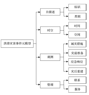
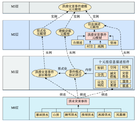
Fig. 1 Flood event meta-model图1 洪涝灾害事件元模型 |
Fig. 2 Build flood event meta-model based on MOF图2 系统框架 |
Fig. 3 UML diagram of flood event meta-model图3 洪涝灾害事件UML图 |
Fig. 4 Main structure of EML Schema图4 EML Schema主要结构 |
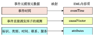
Fig. 5 Mapping between flood event meta-model and EML图5 洪涝灾害事件模型与EML的映射 |
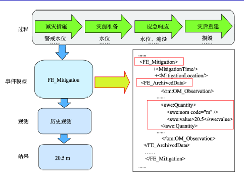
Fig. 6 An instance in Mitigation phase图6 减灾措施阶段实例 |
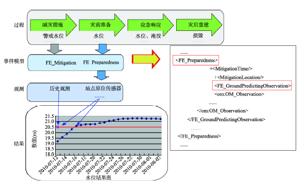
Fig. 7 An instance in Preparedness phase图7 灾前准备阶段实例 |
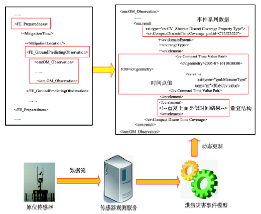
Fig. 8 Process of dynamic modelling图8 动态建模过程 |
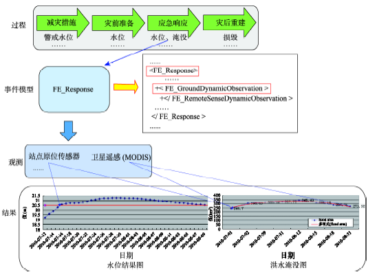
Fig. 9 An instance inresponse phase图9 应急响应阶段实例 |
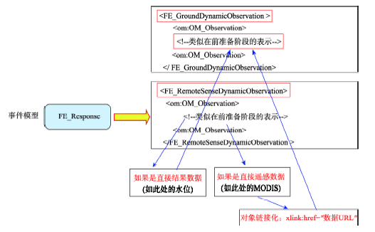
Fig. 10 Encoding method for remote sensing data图10 遥感数据编码方法 |
The authors have declared that no competing interests exist.
| [1] |
|
| [2] |
|
| [3] |
|
| [4] |
|
| [5] |
|
| [6] |
|
| [7] |
|
| [8] |
|
| [9] |
|
| [10] |
|
| [11] |
|
| [12] |
|
| [13] |
|
| [14] |
|
| [15] |
|
| [16] |
Chen, N, Di L, Yu G. A flexible geospatial sensor observation service for diverse sensor data based on Web service[J]. ISPRS Journal of Photogrammetry and Remote Sensing, 2009,64(1):274-282.
|
| [17] |
|
| [18] |
|
| [19] |
|
| [20] |
|
| [21] |
|
| [22] |
|
/
| 〈 |
|
〉 |