
基于空间抽样的区域地表覆盖遥感制图产品精度评估——以中国陕西省为例
作者简介:孟 雯(1989-),女,上海人,硕士生,研究方向为空间数据质量控制与抽样检验研究。E-mail: mengwen_1106@163.com
收稿日期: 2015-01-04
要求修回日期: 2015-03-11
网络出版日期: 2015-06-10
基金资助
国家自然科学基金项目(41171352)
Accuracy Assessment for Regional Land Cover Remote Sensing Mapping Product Based on Spatial Sampling: A Case Study of Shaanxi Province, China
Received date: 2015-01-04
Request revised date: 2015-03-11
Online published: 2015-06-10
Copyright
地表覆盖数据是研究气候变化、生态环境、地理国情和人文经济等方面不可或缺的基础信息,因此其质量的优劣将直接影响相关决策的可靠性。本文针对我国研制的首套30 m分辨率全球地表覆盖数据产品,通过分析其海量、多维、非均质等空间特点,对传统的制图产品精度评估方法提出了改进:以地表类型进行分层抽样,样本量的计算采用优化模型并以地类所占面积比为权重逐层分配,样本的布设则考虑层内对象之间的空间相关性,在地表数据自然分布的基础上,通过分析空间相关性指数来提高样本的代表性和精度评估结果的可靠性。因此,本文提出针对区域地表覆盖遥感制图产品的空间分层抽样方法,其将精度评估分成抽样方案(样本的定量估计)和布设方案(样本的空间布设)2个部分,并以中国陕西省地表覆盖产品为例进行区域精度评估实验分析,从全区7大类地表类型数据中抽取1467个样本,经过样本检验与精度计算,该区域产品的总体精度为79.96%,Kappa系数为0.74。实验结果表明,本文提出的基于空间抽样的精度评估方法可行可靠,实验区域产品质量较好,并为后续针对全球范围的地表覆盖产品精度评估方法提供了参考。
孟雯 , 童小华 , 谢欢 , 王振华 . 基于空间抽样的区域地表覆盖遥感制图产品精度评估——以中国陕西省为例[J]. 地球信息科学学报, 2015 , 17(6) : 742 -749 . DOI: 10.3724/SP.J.1047.2015.00742
Land cover refers to the complex of various materials of the earth's surface and its natural attributes and characteristics. Land cover data at global scale is fundamental and indispensable for global change studies, and its data quality has been the focus of a variety of international communities. In 2010, China launched the project of 30 m Global Land Cover remotely sensed products with 10 classifications for the base years of 2000 and 2010, which takes a four year period to complete, and the data quality issue will affect its subsequent applications. This paper mainly studies the accuracy assessment method for regional land cover data, as a preliminary of global validation. First, the spatial characteristics of land cover data are discussed, such as being massive, multi-dimensional, and heterogeneous. Then, a general approach based on spatial stratified sampling method for the accuracy assessment of regional land cover product is proposed to improve the traditional sampling method. Considering the spatial characteristics, this article presents the method of spatial stratified sampling: stratified sampling is conducted according to land cover type, the total sample size is calculated using probability and statistics optimal model, and the sample size of each layer is allocated according to the area ratio; while in the sample spatial allocation process, the representative of sample, which implies that the spatial correlation between samples should be low, needed to be considered. In each layer, each sample's spatial correlation is calculated by Moran's I index, and by setting a threshold value, the representative samples are chosen. The final sample set of each layer is randomly selected based on spatial analysis. The spatial sampling scheme is divided into three parts: sampling method, determination of sample size and the sample allocation. We have made an improvement in this paper, by designing a two-step scheme, which are quantitative estimation of sample size and spatial allocation. A case study of Shaanxi Province of China shows the method and process of accuracy assessment for regional land cover product. 1467 samples are selected by spatial stratified sampling in 7 strata. According to the confusion matrix, the overall accuracy is 79.96% and kappa index is 0.74. User's accuracies of all land cover types are more than 75%, while producer's accuracies fluctuate due to the low sample size caused by the low area ratio, which have little impact on the overall accuracy. Experimental results show that the proposed method is applicable to accuracy assessment of regional land cover product. Study on global land cover product will be performed as a main research direction in future.
Key words: land cover; spatial sampling; spatial correlation; accuracy assessment
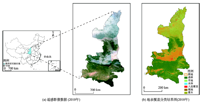
Fig. 1 Geographical location and content of experimental data图1 实验数据的地理位置和数据内容 |
Tab. 1 Classification system of Shaanxi Province's data and the corresponding expected classification accuracy表1 中国陕西省地表类型分类系统及对应的预计分类精度表 |
| 序号 | 一级类名称 | 内容 | 预计分类精度(%) |
|---|---|---|---|
| 1 | 耕地 | (雨养旱地、灌溉间作)、稻田、温室菜地、土地、人工牧草地、农田、种植经济作物或灌木草本作物的耕地、土地复垦废弃 | 80 |
| 2 | 森林 | 落叶阔叶林、常绿阔叶林、落叶针叶林、针叶林、针阔混交林 | 85 |
| 3 | 草地 | 典型草原、草甸草原、高寒草原、荒漠草原、草 | 70 |
| 4 | 水体 | 湖泊、水库、鱼塘、河流 | 85 |
| 5 | 人造覆盖 | 居民地、工业用地或矿区、交通设施 | 80 |
| 6 | 裸地 | 盐碱地、沙、砾石、岩石、生物土壤结皮 | 85 |
| 7 | 灌木 | 沙漠灌丛、高山灌丛、落叶和常绿灌木 | 70 |
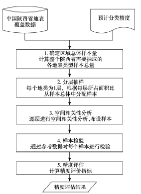
Fig. 2 The flow chart of accuracy assessment on theland-cover data of Shaanxi Province图2 中国陕西省地表数据精度评估流程图 |
Tab. 2 Calculation of sample size of Shaanxi Province表2 陕西省样本总量计算过程 |
| 序号 | 类型 | 像元数(个) | 预计分类精度(%) | 面积比(%) | p值(%) | 样本总量 |
|---|---|---|---|---|---|---|
| 1 | 耕地 | 60 126 746 | 80 | 26 | ||
| 2 | 森林 | 91 027 419 | 85 | 39 | ||
| 3 | 草地 | 38 528 577 | 70 | 16 | ||
| 4 | 水体 | 1 124 905 | 85 | 2 | ||
| 5 | 人造覆盖 | 3 494 298 | 80 | 2 | ||
| 6 | 裸地 | 3 964 620 | 85 | 2 | ||
| 7 | 灌木 | 30 053 218 | 70 | 13 | ||
| 计算结果 | 20.75 | 1467 | ||||
注:面积比是类型像元数与像元总量的比值 |
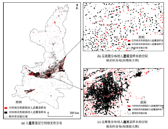
Fig. 3 Spatial correlation analysis of artificial surface layer图3 人造覆盖分层的样本空间相关性分析 |
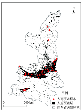
Fig. 4 The allocation of artificial surface samples图4 人造覆盖层样本布设结果 |
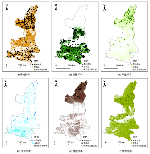
Fig. 5 The sample allocationfor each layer图5 各分层的样本布设 |
Tab. 3 The distribution of sample size in each layer表3 分层抽样样本量分配 |
| 层 | 类型 | 面积比(%) | 每层样本量 |
|---|---|---|---|
| 1 | 耕地 | 26 | 381 |
| 2 | 森林 | 39 | 572 |
| 3 | 草地 | 16 | 234 |
| 4 | 水体 | 2 | 30 |
| 5 | 人造覆盖 | 2 | 30 |
| 6 | 裸地 | 2 | 30 |
| 7 | 灌木 | 13 | 190 |
Tab. 4 Confusion matrix of all samples in Shaanxi Province表4 陕西省所有类型样本的混淆矩阵 |
| 真 实 类 型 | 分类类型 | ||||||||
|---|---|---|---|---|---|---|---|---|---|
| 类型 | 耕地 | 森林 | 草地 | 水体 | 人造覆盖 | 裸地 | 灌木 | 真实总量 | |
| 耕地 | 304 | 31 | 26 | 2 | 5 | 1 | 16 | 385 | |
| 森林 | 14 | 468 | 0 | 0 | 0 | 0 | 4 | 486 | |
| 草地 | 27 | 18 | 176 | 0 | 1 | 3 | 13 | 238 | |
| 水体 | 7 | 10 | 3 | 25 | 1 | 0 | 0 | 46 | |
| 人造覆盖 | 8 | 10 | 5 | 3 | 23 | 0 | 0 | 49 | |
| 裸地 | 14 | 10 | 18 | 0 | 0 | 26 | 6 | 74 | |
| 灌木 | 7 | 25 | 6 | 0 | 0 | 0 | 151 | 189 | |
| 分类总量 | 381 | 572 | 234 | 30 | 30 | 30 | 190 | 1467 | |
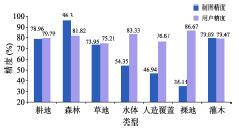
Tab. 5 Producer's accuracy and user's accuracy for each layer表5 各地表类型的制图精度和用户精度 |
| 类型 | 制图精度(%) | 用户精度(%) |
|---|---|---|
| 耕地 | 78.96 | 79.79 |
| 森林 | 96.30 | 81.82 |
| 草地 | 73.95 | 75.21 |
| 水体 | 54.35 | 83.33 |
| 人造覆盖 | 46.94 | 76.67 |
| 裸地 | 35.14 | 86.67 |
| 灌木 | 79.89 | 79.47 |
Fig. 6 Producer's and user's accuracy for each layer图6 陕西省区域地表覆盖遥感制图精度和用户精度图 |
The authors have declared that no competing interests exist.
| [1] |
|
| [2] |
|
| [3] |
|
| [4] |
|
| [5] |
|
| [6] |
|
| [7] |
|
| [8] |
|
| [9] |
|
| [10] |
|
| [11] |
|
| [12] |
|
| [13] |
|
| [14] |
|
| [15] |
|
| [16] |
|
/
| 〈 |
|
〉 |