
基于Monte Carlo模拟的地物适宜尺度提取分析
作者简介:祝俊祥(1989-),男,浙江兰溪人,硕士生,研究方向为地理信息系统技术及应用。E-mail: zhujx@lreis.ac.cn
收稿日期: 2014-12-31
要求修回日期: 2015-02-22
网络出版日期: 2015-07-08
基金资助
国家科技基础性工作重点项目(2011FY110400)
中国科学院信息化专项项目(XXH12504-1-01)
Study on Acquiring Appropriate Scales of Ground Features Based on Monte Carlo Simulation
Received date: 2014-12-31
Request revised date: 2015-02-22
Online published: 2015-07-08
Copyright
半方差函数可探测空间过程的影响范围,常用于分析遥感信息提取的适宜尺度,然而在进行大样本数据处理时,会受到计算机运算、存储等方面性能的制约。传统的做法往往直接采用随机抽样来减少数据量,其虽然降低了分析过程对计算机性能的要求,但同时也会降低分析结果的精度。因此,本文提出一种Monte Carlo模拟影像空间结构估算方法,其以小的样本量对大样本进行大量随机重复采样,在降低单次模拟数据量、运算量的同时,以充分的模拟量保证分析结果的精度。在此基础上,为了减少模拟所需时间,本研究引入并行计算,采用多核单计算机平台,进行多种地物适宜尺度提取分析的并行处理。实验与分析表明,该方法能较好地估算目标区域常见地物的适宜表达尺度(估计误差较小)。
关键词: Monte Carlo模拟; 半方差分析; 适宜尺度; 格网
祝俊祥 , 王卷乐 . 基于Monte Carlo模拟的地物适宜尺度提取分析[J]. 地球信息科学学报, 2015 , 17(7) : 798 -803 . DOI: 10.3724/SP.J.1047.2015.00798
The semi-variogarm has been widely applied in many fields such as mining, soil science, and environmental science to acquire the impact range of spatial process. In remote sensing, it could be used to analyze the spatial structure of remote sensing images or obtain appropriate scales for ground features in the images. Nevertheless, images with huge sizes make the application of semi-variogram on remote sensing different from other disciplines. The computers, on which the semi-variogram curves are calculated and fitted, need more memory and stronger CPUs, which is seemingly impossible to always meet the requirement. A common solution is to decrease the data volume by random sampling, under this circumstance. Specifically, a small amount of samples are selected randomly from the population and analyzed for supposed result instead of using the whole population. This method does decrease the requirement of analysis for computing capacity and memory of computers. However, the accuracy of analysis drops simultaneously, because the result derived from samples in one single sampling is likely to contain errors. To solve this problem that related to spatial structure analysis, this study proposed a method based on Monte Carlo simulation in which a small amount of samples are taken from the huge-volume population for enormous times and then analyzed respectively. In this way, the amount of computation in a single simulation can be reduced to the level that an average computer could tolerate, meanwhile the accuracy can be guaranteed. Also, the parallel computing technology was introduced in this study in order to minimize the time needed for simulation. The parallel computing of semi-variogram was executed in MATLAB whose parallel computing service is simple and easy to manipulate. The experimental area is a rectangular part of An'sai County of Shaanxi Province, China, with an area of 41.32 square kilometers. In this area, there are many types of ground features such as forest, grass, water, farmland and built area. Among all these features, grass is the dominant one. The simulation result shows that, this method could acquire appropriate scales for the common ground features while keeping the estimation errors low.
Key words: Monte Carlo simulation; semi-variogram; appropriate scale; grid
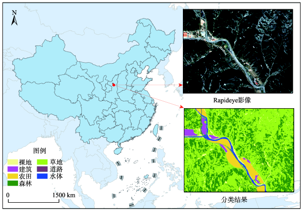
Fig. 1 The test site location图1 试验区位置图 |
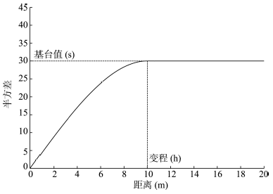
Fig. 2 An ideal semi-variogram图2 理论半方差图 |
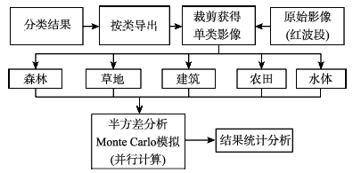
Fig. 3 Experiment workflow图3 实验流程 |
Fig. 4 The probability distribution of simulation ranges图4 模拟变程概率分布 |
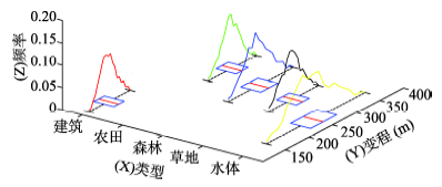
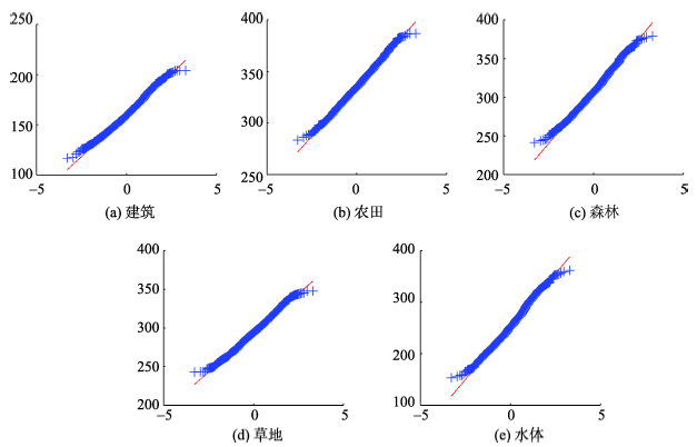
Fig. 5 The normality test of all simulation results图5 各地物类型模拟结果的正态性检验 |
Tab. 1 The statistical analysis of simulation results表1 模拟结果统计分析 |
| 建筑(m) | 农田(m) | 森林(m) | 草地(m) | 水体(m) | |
|---|---|---|---|---|---|
| 中值 | 159.3 | 334.9 | 307.1 | 294.1 | 252.0 |
| 均值 | 160.6 | 335.7 | 308.4 | 294.4 | 253.9 |
| 方差 | 277.9 | 366.6 | 695.0 | 437.8 | 1664.3 |
Tab. 2 The 95% and 99% confidence intervals of all ground features表2 各地物类型95%、99%置信区间 |
| 建筑(m) | 农田(m) | 森林(m) | 草地(m) | 水体(m) | |
|---|---|---|---|---|---|
| 95%置信上限 | 161.6 | 336.8 | 310.0 | 295.7 | 256.5 |
| 95%置信下限 | 159.5 | 334.5 | 306.8 | 293.1 | 251.4 |
| 99%置信上限 | 161.9 | 337.2 | 310.5 | 296.1 | 257.3 |
| 99%置信下限 | 159.2 | 334.1 | 306.2 | 292.7 | 250.6 |
The authors have declared that no competing interests exist.
| [1] |
|
| [2] |
|
| [3] |
|
| [4] |
|
| [5] |
|
| [6] |
|
| [7] |
|
| [8] |
|
| [9] |
|
| [10] |
|
| [11] |
|
| [12] |
|
| [13] |
|
| [14] |
|
| [15] |
|
| [16] |
|
| [17] |
|
| [18] |
|
| [19] |
|
| [20] |
|
/
| 〈 |
|
〉 |