
闽南金三角地区城市扩展及其驱动分析——以漳州市主城区为例
作者简介:郭燕滨(1989-),女,福建漳州人,硕士生,研究方向为环境与资源遥感。E-mail: gyb1026@qq.com
收稿日期: 2014-12-16
要求修回日期: 2015-01-04
网络出版日期: 2015-08-05
基金资助
国家科技支撑计划课题“南方红壤水土流失治理技术研究与示范”(2013BAC08B01-05)
Analysis of Spatio-temporal Expansion for the Golden Triangle Region in South Fujian Province, China: A Case Study of Zhangzhou Urban Area
Received date: 2014-12-16
Request revised date: 2015-01-04
Online published: 2015-08-05
Copyright
城市空间扩展是衡量城市化进程的重要指标。本文以闽南金三角地区的福建省漳州市主城区作为研究区,选取2000、2006和2013年的Landsat遥感影像,利用IBI建筑指数分别提取了3个年份的建筑用地信息,然后对其变化进行GIS分析。结果表明,13 a间漳州市主城区面积净增13.69 km2,净增面积为2000年的66.9%。主城区主要沿交通主干道往西北方向呈带状和面状扩展。缓冲区分析表明,道路对主城区扩展起到很大的引导和促进作用。综合社会经济数据可知,主城区的城市扩展历程与第二产业的发展密切相关,属工业导向型的城市扩展模式。另外,城市人口的增加也起到了一定的促进作用,不同区位人口增长速率的差异,对城市扩展的方向也产生了一定的引导作用。
郭燕滨 , 徐涵秋 , 张灿 , 林思乡 . 闽南金三角地区城市扩展及其驱动分析——以漳州市主城区为例[J]. 地球信息科学学报, 2015 , 17(8) : 927 -936 . DOI: 10.3724/SP.J.1047.2015.00927
Urban expansion, in which the non-urban land use is converted to urban land use, is an important aspect of urbanization. Three Landsat time-series images for 2000, 2006 and 2013 of Zhangzhou city, which is located in Southern Fujian Golden Triangle Region, have been used to study the urban expansion of Zhangzhou urban area with the assistance of remote sensing and GIS technology. The index-based built-up index (IBI) was used to extract urban build-up land information of Zhangzhou from the three images. The extended urban range and expanded urban area were obtained by applying overlay analysis on the vectorized maps allocated in eight quadrants. The result indicated that during the 13-year study period, the urban built-up area of Zhangzhou had a net increase of 13.69 km2, which was 66.9% more than the area in 2000. The calculation showed that the built-up land expanded more rapidly in the period between 2000 and 2006. The urban area expanded toward the northwest direction in a planar and linear way, which was mainly along the three main traffic lines of Zhangzhou. The buffer analysis showed that the traffic line distribution had a significant impact on urban expansion. Driving force analysis indicated that the fast economic development and population increase were the driving forces to the expansion of Zhangzhou urban area. Socio-economic data showed that Zhangzhou´s urban expansion was closely related to the growth rate of the city´s secondary industry. Its expansion pattern belonged to the industry oriented expansion. Besides, the different growth rates of population in different regions also played an important role in Zhangzhou urban area growth, which resulted in the expansion of urban area toward the north-west district. Overall, the imbalanced growth ratio between urban land area and population implied the irrational urban land development in this city. The urban expansion derived by industrial development can be represented with a traditional urban-development model. Therefore, a faster development of tertiary industry for Zhangzhou is crucial to improve the city´s developing quality. Nevertheless, when shifting the planning focus from industrial structure to tertiary industry, the decision makers should pay attention to the intelligent use of urban land.
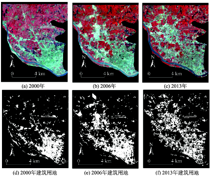
Fig. 1 Remote sensing images and the extracted built-up lands of Zhangzhou urban area in 2000, 2006 and 2013图1 研究区不同年份的遥感影像及其对应的建筑用地提取影像 |
Tab. 1 Accuracy validation results of the extracted built-up lands表1 建筑用地精度验证 |
| 年份 | 参考数据 | 行像元总数 | 使用者精度(%) | 总精度(%) | Kappa系数 | ||
|---|---|---|---|---|---|---|---|
| 建筑用地 | 非建筑用地 | ||||||
| 2000 | 建筑用地 | 45 | 4 | 49 | 91.84 | 94.0 | 0.864 |
| 非建筑用地 | 5 | 96 | 101 | 95.05 | |||
| 列像元总数 | 50 | 100 | 150 | ||||
| 生产者精度(%) | 90.00 | 96.00 | |||||
| 2006 | 建筑用地 | 46 | 8 | 54 | 85.19 | 90.7 | 0.8 |
| 非建筑用地 | 6 | 90 | 96 | 93.75 | |||
| 列像元总数 | 52 | 98 | 150 | ||||
| 生产者精度(%) | 88.46 | 91.84 | |||||
| 2013 | 建筑用地 | 75 | 6 | 81 | 92.59 | 92.7 | 0.853 |
| 非建筑用地 | 5 | 64 | 69 | 92.75 | |||
| 列像元总数 | 80 | 70 | 150 | ||||
| 生产者精度(%) | 93.75 | 91.42 | |||||
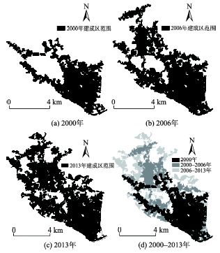
Fig. 2 Spatio-temporal changes of Zhangzhou urban area in 2000, 2006 and 2013图2 研究区不同年份的主城区空间变化 |
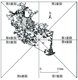
Fig. 3 The partition of eight quadrants for Zhangzhou urban area图3 研究区象限的划分 |
Tab. 2 Built-up lands and relevant indicators of Zhangzhou urban area表2 漳州市城市主城区及相关指标 |
| 年份 | 时段 | ||||||
|---|---|---|---|---|---|---|---|
| 2000 | 2006 | 2013 | 2000-2006 | 2006-2013 | 2000-2013 | ||
| 主城区面积(km2) | 20.47 | 26.95 | 34.16 | - | - | - | |
| 新增面积(km2) | - | - | - | 6.48 | 7.21 | 13.69 | |
| 净增长率(%) | - | - | - | 31.66 | 26.75 | 66.88 | |
| 年平均净增长率(%) | - | - | - | 5.28 | 3.82 | 5.14 | |
| 城市扩展强度 | - | - | - | 0.415 | 0.396 | 0.405 | |
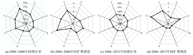
Fig. 4 Urban expansions indicated in different quadrants with respect to different periods图4 各个时期不同象限建筑用地统计数据 |
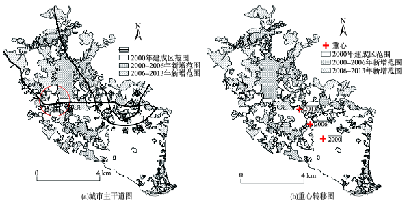
Fig. 5 The distribution of main traffic lines and movement of urban center for Zhangzhou urban area图5 漳州主城区的城市主干道及重心转移图 |
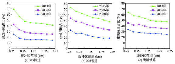
Fig. 6 Changes of built-up land ratios regarding to different buffer zones of the three major traffic lines in Zhangzhou urban area图6 漳州主城区的城市主干道不同缓冲区范围的建筑用地占比 |
Tab. 3 Statistics of built-up lands along different major traffic lines表3 不同主干道沿线建筑用地统计数据 |
| 建筑用地 | 类别 | 年份 | 时段 | ||||
|---|---|---|---|---|---|---|---|
| 2000 | 2006 | 2013 | 2000-2006 | 2006-2013 | |||
| 319国道 | 面积(km2) | 2.14 | 3.98 | 6.78 | 1.84 | 2.80 | |
| 占缓冲区面积比(%) | 17.90 | 33.30 | 56.70 | - | - | ||
| 占总增加面积比(%) | - | - | - | 28.4 | 38.90 | ||
| 208省道 | 面积(km2) | 3.35 | 6.02 | 8.31 | 2.68 | 2.28 | |
| 占缓冲区面积比(%) | 26.60 | 47.90 | 66.10 | - | - | ||
| 占总增加面积比(%) | - | - | - | 41.30 | 31.60 | ||
| 鹰厦铁路 | 面积(km2) | 1.95 | 2.74 | 3.85 | 0.78 | 1.12 | |
| 占缓冲区面积比(%) | 29.60 | 41.50 | 58.30 | - | - | ||
| 占总增加面积比(%) | - | - | - | 12.10 | 15.50 | ||
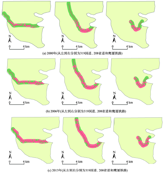
Fig. 7 Distribution of built-up lands within 500 m buffer zones along the major traffic lines图7 主干道500 m缓冲区内建筑用地分布 |
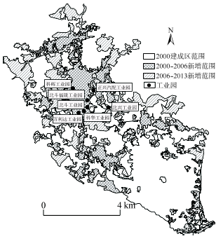
Fig. 8 Distribution of industrial parks in Zhangzhou urban area图8 漳州主城区的工业园区分布图 |
Tab. 4 Socio-economic statistical data of Xiangcheng district in Zhangzhou from 2000-2013表4 2000-2013年漳州市芗城区社会经济统计数据 |
| 2000年 | 2006年 | 2013年 | 2000-2013年间增减 | |
|---|---|---|---|---|
| 总人口(万人) | 38.90 | 41.99 | 44.05 | 5.15 |
| 非农业人口(万人) | 23.58 | 27.19 | 33.91 | 10.33 |
| 城市化率(%) | 60.62 | 64.75 | 76.98 | 27.00 |
| 地方生产总值(亿元) | 70.26 | 136.52 | 386.04 | 315.78 |
| 第一产业比重(%) | 5.35 | 3.81 | 2.40 | -55.08 |
| 第二产业比重(%) | 43.60 | 48.65 | 48.57 | 11.40 |
| 工业(%) | 34.49 | 41.66 | 37.68 | 9.23 |
| 规模以上工业总产值(亿元) | 32.55 | 168.12 | 535.33 | 502.77 |
| 轻工业(%) | 69.42 | 46.91 | 35.71 | -48.57 |
| 重工业(%) | 30.58 | 53.09 | 64.29 | 110.28 |
| 建筑业(%) | 9.12 | 6.99 | 10.89 | 19.47 |
| 第三产业比重(%) | 51.05 | 47.53 | 49.03 | -3.97 |
Tab. 5 Population changes of the main urban areas of Zhangzhou in 2000-2013表5 2000-2013年间漳州市主城区的人口变化 |
| 地区 | 2000年(人) | 2006年(人) | 2013年(人) | 2000-2013年增减(人) | 平均年净增长率(%) |
|---|---|---|---|---|---|
| 芝山镇 | 17 432 | 17 774 | 21 450 | 4018 | 1.77 |
| 天宝镇 | 47 593 | 48 263 | 49 852 | 2259 | 0.37 |
| 石亭镇 | 37 114 | 38 123 | 40 730 | 3616 | 0.75 |
| 浦南镇 | 31 084 | 30 185 | 31 246 | 162 | 0.04 |
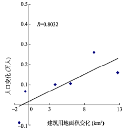
Fig. 9 Correlation between the increase of built-up land and population growth图9 建筑用地与人口数量变化的相关分析 |
The authors have declared that no competing interests exist.
| [1] |
|
| [2] |
|
| [3] |
|
| [4] |
|
| [5] |
|
| [6] |
|
| [7] |
|
| [8] |
|
| [9] |
|
| [10] |
|
| [11] |
|
| [12] |
|
| [13] |
|
| [14] |
|
| [15] |
|
| [16] |
|
| [17] |
|
| [18] |
|
| [19] |
|
| [20] |
|
| [21] |
|
| [22] |
|
| [23] |
|
| [24] |
漳州市芗城区国民经济统计年鉴2000[M].漳州市芗城区统计局内部资料, 2000.
|
| [25] |
漳州市芗城区国民经济统计年鉴2006[M].漳州市芗城区统计局内部资料, 2006.
|
| [26] |
福建省统计局.福建统计年鉴2014[M].北京:中国统计出版社,2014.
|
| [27] |
漳州市国民经济和社会发展第十一个五年规划纲要[EB/OL]. (2006) [2014-07-10].
|
/
| 〈 |
|
〉 |