
多时相HJ-1数据补充的水体分布时序变化监测
作者简介:王卫红(1969-),男,浙江人,教授,研究方向为遥感信息提取,空间信息服务等。E-mail: wwh@zjut.edu.cn
收稿日期: 2014-10-30
要求修回日期: 2014-12-11
网络出版日期: 2015-09-07
基金资助
国家“863”计划项目(2013AA12A401);中国科学院创新方向性项目(KZZD-EW-07-02);国家自然科学基金青年基金项目(41301473);浙江省自然科学基金重点项目(LZ14F020001)
Monitoring Water Distribution Changes Based on the Supplemented Multi-temporal HJ-1 Data
Received date: 2014-10-30
Request revised date: 2014-12-11
Online published: 2015-09-07
Copyright
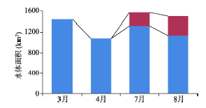
由于地域、天气等原因造成的云影问题,导致了水体时序分析困难。本文以资源三号(ZY-3)影像作为辅助数据,以环境与灾害监测预报小卫星影像(HJ-1)作为研究数据,通过提取一个时间段内多景时相相近HJ-1数据中有效水体信息,迭代补充成完整的水体提取结果,将不同时间段内影像水体提取的完整结果形成时序监测数据,以达到对某地区水体时序变化监测的目的。通过对淮河流域安徽段研究区水体分布监测表明,该方法能充分利用每个时间段内质量不理想的源数据,对相近时相数据迭代补充,完整提取该时间段内的水体信息。多个时间段迭代补充形成的时序数据可有效支持时序监测。本文在研究区共选取了8295个查找点,结果表明:2013年该研究区洪季(7、8月)水体信息比旱季(3、4月)更丰富,特别是东南部在洪季形成了许多零散水体;相较于旱季,洪季研究区水域面积增长了22.1%。
王卫红 , 黄琳 , 夏列钢 . 多时相HJ-1数据补充的水体分布时序变化监测[J]. 地球信息科学学报, 2015 , 17(9) : 1110 -1118 . DOI: 10.3724/SP.J.1047.2015.01110
Cloud and shadow contained in satellite images usually causes inaccuracy in water extraction and brings difficulty to time-series analysis of water resources. In this paper, we took HJ-1 as the primary data and ZY-3 data as the auxiliary data to extract water information and monitor water distribution changes. To find the potential location of water, we randomly selected a series of check points using ZY-3 data. Based on the uniformly distributed check points calculated from the ZY-3 data, we examined the integrity of the water extraction result of HJ-1 data. If the extraction result was not integrated, we supplemented it with the water extraction result from images that are obtained within an adjacent time period, according to a check points based strategy. These supplemented extraction results in different periods formed a completed time-series dataset that provided a reliable way to monitor the water resources and distribution changes. The experiment was carried out on analyzing the Anhui section of Huaihe River watershed, and its results showed that this method took full advantage of the images within adjacent time. Even if the image quality was poor, this method managed to produce a more integrate result in comparison with the use of a single HJ-1 image. The randomly calculated check points minimized the manual intervention, thus provided an accurate and effective way to monitor the time-series of water resources. In the study area, 8295 check points were extracted. The results revealed the water resources of the study area in the rainy seasons (July and August) were more abundant than dry seasons (March and April) in 2013; especially, many temporary water bodies had been detected in the south of the watershed in the rainy seasons. The total water area had increased 22.1% in the rainy seasons compared to the dry seasons.
Key words: information supplement; water extraction; time-series monitoring; HJ-1
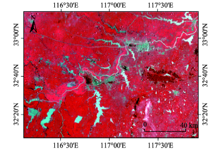
Fig. 1 HJ-1 data with color composition (4, 3 and 2 bands) for the study area on July 29th, 2013图1 2013年7月29日研究区HJ-1数据(4、3、2波段合成) |
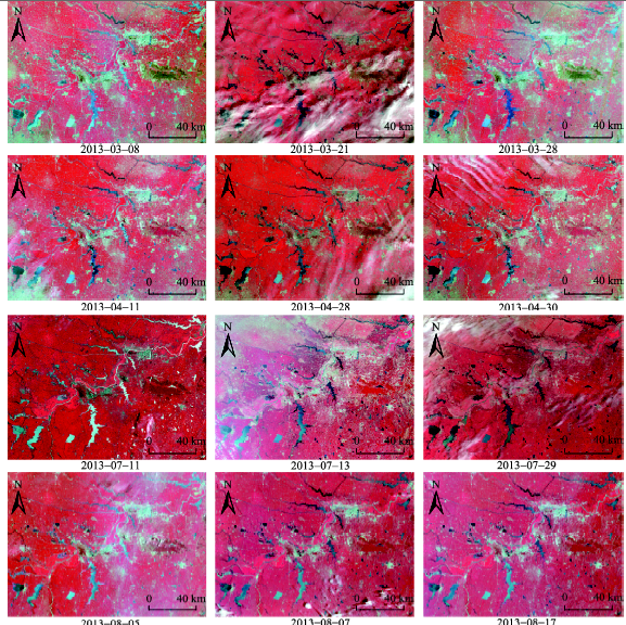
Fig. 2 Data sources of the study area: the HJ-1 data captured respectively in March, April, July and August, 2013图2 研究区2013年3、4、7、8月HJ-1数据 |
Fig. 3 Water extraction of the study area in March and July图3 研究区3、7月水体提取情况 |
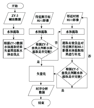
Fig. 4 The flow chart of monitoring on water changes图4 水体时序变化监测流程图 |
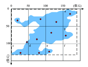
Fig. 5 Schematic diagram of check points selection图5 查找点选取示意图 |
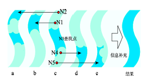
Fig. 6 Schematic diagram of information supplementing process图6 信息补充过程示意图 |
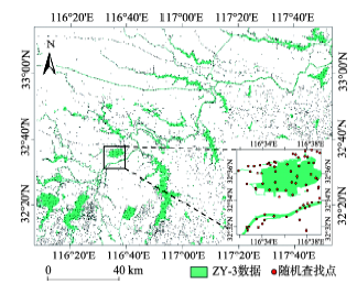
Fig. 7 The result of check points selection图7 查找点选取结果 |
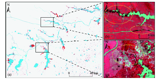
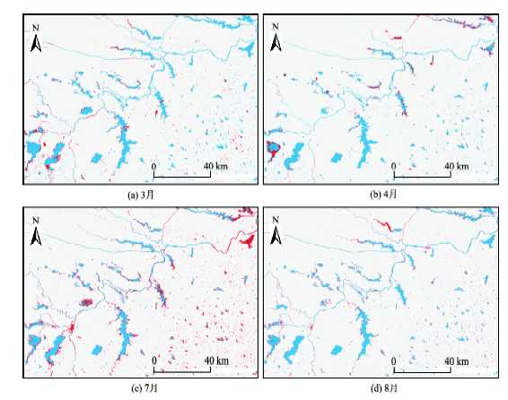
Fig. 8 Comparison of water extraction results (blue) with supplemented results (red) for March, April, July and August图8 3、4、7和8月水体提取结果(蓝)与信息补充结果(红)对比图 |
Fig. 9 The histogram of water area图9 水域面积柱状图 |
Fig. 10 Water plants are thriving in the study area in June and July图10 研究区7、8月水生植物生长旺盛 |
The authors have declared that no competing interests exist.
| [1] |
|
| [2] |
|
| [3] |
|
| [4] |
|
| [5] |
|
| [6] |
|
| [7] |
|
| [8] |
|
| [9] |
|
| [10] |
|
| [11] |
|
| [12] |
|
| [13] |
|
| [14] |
|
| [15] |
|
| [16] |
|
| [17] |
|
| [18] |
|
| [19] |
|
| [20] |
|
/
| 〈 |
|
〉 |