
无参数高分辨率遥感影像的建筑高度快速提取方法
作者简介:乔伟峰(1975-),男,博士后,研究方向为土地遥感和GIS应用。E-mail: qwf@263.net
收稿日期: 2014-10-22
要求修回日期: 2014-11-18
网络出版日期: 2015-08-05
基金资助
国家自然科学基金项目(41371172、41130748)
中国博士后科学基金项目(2014M561040)
江苏高校优势学科建设工程资助项目(164320H116)
Research on Extracting Building Height Rapidly Based on High-resolution Remote Sensing Images Without Parameters
Received date: 2014-10-22
Request revised date: 2014-11-18
Online published: 2015-08-05
Copyright
无参数高分辨率遥感影像快速提取建筑高度,在城市建设和土地管理中有重要的现实意义。当前的研究多以已知参数的遥感影像获取,但其提取方法受限制条件多。本文提出以无参数高分辨率遥感影像,综合利用单张影像上的特征点所构成的4类特征线换算建筑高度的方法。4类特征线包括屋顶位移点与其阴影点的连线、建筑高差引起的屋顶像点位移、阴影全长和建筑遮挡后的阴影长。通过已知的少量建筑的实际高度和推导出的4类特征线换算建筑高度的计算模型,可对大量建筑进行快速、精确地高度量算。结合南京市的Google Earth影像进行了验证,结果表明,该方法采用的影像易于获得,综合量算方法大大增加了单张影像上提取建筑高度的可操作性,并解决了量算建筑高度时无相关参数的问题。该方法精度较高,可大面积、快速提取建筑高度,在生产实践中有较大的实用价值。
关键词: 无参数影像; 特征线; 换算模型; 建筑高度; Google Earth
乔伟峰 , 刘彦随 , 项灵志 , 王亚华 . 无参数高分辨率遥感影像的建筑高度快速提取方法[J]. 地球信息科学学报, 2015 , 17(8) : 995 -1000 . DOI: 10.3724/SP.J.1047.2015.00995
There is a pressing need to extract building height rapidly based on high-resolution remote sensing images without parameters in the field of urban construction and land management. Current studies are mostly based on remote sensing images with parameters, however the images used for extraction are difficult to get, and current extraction methods have a lot of restrictions. In this paper, a new method is proposed with the use of four types of characteristic lines. The characteristic lines are comprehensively formed by the characteristic points on a single image, which is used to convert the building height based on high-resolution images without parameters. The four types of characteristic lines include: the connection line of the roof displacement point and roof shadow point, the displacement of the roof image point caused by the building height, the full-length shadow, the remaining length of the shadow excluding the part occluded by building. Four types of calculation model for acquiring building height based on the corresponding characteristic lines are deduced. According to the known heights of a small amount of constructions and using the four calculation models, the relevant parameters of remote sensing images can be derived conversely. Then, we can select the characteristic lines that are extracted most accurately on each building , and use the corresponding model to convert the building height. With the application of this method, a large number of building heights can be calculated quickly and accurately. The method is verified based on Google Earth image in Nanjing city and the results show: the images used in this approach are easy to acquire; the method of comprehensive measurement and calculation does not merely rely on the use of shadow lengths to calculate building height, so it significantly increases the practicality of extracting building height on a single image; it solves the issue that there is no related angle parameters of the sun and the satellite position when calculating the building height. Case study indicated that the precision of the proposed method is high, and it can extract the building height quickly in a large area. Generally, the method proposed in this paper has significant practical value in production applications.
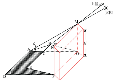
Fig. 1 Schematic diagram of satellite imaging图1 卫星成像示意图 |
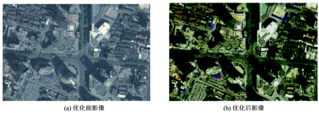
Fig. 2 Comparison of graphs before and after applying the image enhancement图2 影像增强处理前后对比图 |
Tab. 1 Difficulty level analysis of characteristic line extractions表1 特征线段提取难易度分析 |
| 特征线段种类 | 提取影响因素 | 提取难易度 |
|---|---|---|
| l1 | 建筑密集区的建筑阴影易被周围建筑遮挡;当待测建筑物周围有水面和植被时,建筑物阴影和这些低灰度值区不易区分;当太阳和卫星处于建筑同侧时,阴影全长易被建筑本身的投影遮挡 | 阴影全长提取中问题较多,使用较少 |
| l2 | 卫星高度角大于80°时屋顶像点位移不明显;当高层建筑下面有裙楼时,屋顶对应的地面点不易确定 | 提取较方便,使用较多 |
| l3 | 阴影中的任意角点和与之匹配的屋顶角点成像点选择较方便 | 提取较方便,使用较多 |
| l4 | 影响因素和l1提取相近 | 提取中问题较多,计算中涉及到δ角度,需另外量算,一般不使用 |
The authors have declared that no competing interests exist.
| [1] |
|
| [2] |
|
| [3] |
|
| [4] |
|
| [5] |
|
| [6] |
|
| [7] |
|
| [8] |
|
| [9] |
|
| [10] |
|
| [11] |
|
| [12] |
|
| [13] |
|
| [14] |
|
| [15] |
|
| [16] |
|
| [17] |
|
| [18] |
|
| [19] |
|
| [20] |
|
| [21] |
|
| [22] |
|
| [23] |
|
| [24] |
|
| [25] |
|
/
| 〈 |
|
〉 |