
黄土地貌类型的坡谱自动识别分析
作者简介:刘双琳(1990-),女,辽宁大连人,硕士生,主要从事DEM与数字地形分析研究。E-mail: liuslin28@163.com
收稿日期: 2015-01-28
要求修回日期: 2015-03-04
网络出版日期: 2015-10-10
基金资助
国家自然科学基金项目“基于DEM的黄土地貌沟沿线研究”(41171299)、“基于DEM的黄土沟壑种群特征及空间异质性研究”(41271438)
A Method of Loess Landform Automatic Recognition Based on Slope Spectrum
Received date: 2015-01-28
Request revised date: 2015-03-04
Online published: 2015-10-10
Copyright
地貌形态特征识别与分类,对生态环境、水文研究及地质构造分析等地学研究具有重要意义,已成为现代地貌学的一个研究热点。传统的统计模式识别方法精度较低,难以解决线性不可分的模式分类问题。人工方法虽然识别精度高,但因各人认知偏差导致的识别误差难以控制。人工神经网络作为一种动态信息处理系统,能有效解决线性不可分的地貌类型识别问题。坡谱是利用微观地形定量指标来反映宏观地形特征的有效方法,在地貌学研究中正受到广泛的关注。本文以陕北黄土高原8个不同地貌类型区的数字高程模型(DEM)为实验数据,以流域为分析单元,提取坡谱及其特征指标作为描述地形特征的定量因子,并通过BP神经网络的构建与学习,进行黄土地貌类型自动识别。实验结果表明,在8种地貌类型的样本数据中,第1次实验正确识别率平均值达70%;第2次和第3次实验中,去除相似度较高的峁状丘陵沟壑或峁梁状丘陵沟壑任一种地貌类型后,正确识别率平均提升为80%和85%。经Kappa系数验证,该方法能以DEM数据有效识别不同类型的黄土地貌。
刘双琳 , 李发源 , 蒋如乔 , 常瑞雪 , 刘玮 . 黄土地貌类型的坡谱自动识别分析[J]. 地球信息科学学报, 2015 , 17(10) : 1234 -1242 . DOI: 10.3724/SP.J.1047.2015.01234
As a research hot-spot of modern geomorphology, landform recognition and classification are important in various study areas such as ecological environment, hydrology and geological structure analysis. Traditional recognition methods, which are inadequate to solve the linear inseparable problem of pattern recognition, exhibit a low accuracy in landform recognition. As a dynamic information processing system, neural network is capable to deal with linear inseparable in landform recognition. Slope spectrum is an effective method to reflect the macro terrain features with quantitative micro-terrain-indicators. It has been receiving widespread attentions in geomorphology. This paper introduces an automatic recognition method based on slope spectrum and neural network. Using DEM data of eight sample areas with different loess landform types in Shaanxi Province, ten small watersheds and their slope spectrums are extracted for each of the eight sample areas. Then, we calculate the slope spectrum indices of these eighty small watersheds and use the indices to construct BP neural network for loess landform automatic recognition. Among the eighty small watersheds, 60% of them are randomly selected as training samples and 40% of them are selected as verification samples. Recognition results show that the accuracy rate is 70% on average for the eight sample areas, and it would be raised to 80% or 85% when the landform types of Loess Hilly-gully or Loess Hill-ridge are eliminated from the eight sample areas respectively. This study indicates that slope spectrum is capable of handling the linear inseparable problem in landform recognition.
Key words: landform recognition; slope spectrum; DEM; loess landform; neural network
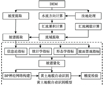
Fig. 1 The flow chart of automatic recognition图1 研究技术流程图 |
Tab. 1 Quantitative indictor of slope spectrum features表1 坡谱特征量化指标 |
| 坡谱特征值 | 公式 | 含义 |
|---|---|---|
| 坡谱信息熵 | 坡谱的信息熵反映坡谱的均匀度或坡谱内各组数据频率的差异程度,频率分布越离散,其信息熵越小 | |
| 坡谱偏度 | 坡谱偏度描述坡度分布的不对称性 | |
| 坡谱平均值 | 坡谱平均值表示该坡谱数据的平均坡度 | |
| 坡谱标准差 | 坡谱标准差反映坡谱数据的离散程度 | |
| 终止坡度 | 终止坡度反映坡谱达到的最大坡度 | |
| 斑块密度 | 斑块密度反映坡度分级的破碎程度及其构成 |
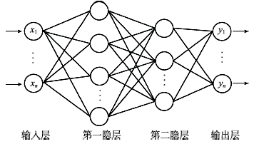
Fig. 2 Recognition framework图2 识别网络结构图 |
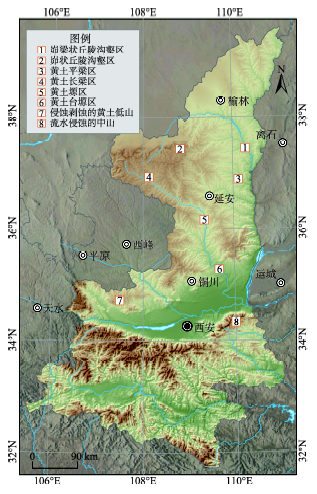
Fig. 3 Study areas图3 实验样区分布图 |
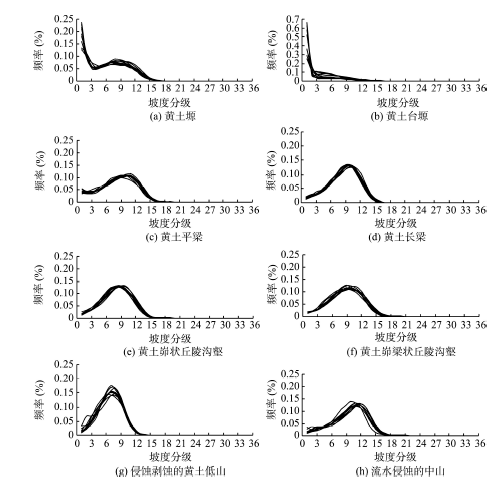
Fig. 4 Slope spectrums in different landform areas图4 实验样区中不同地貌类型样本的坡谱 |
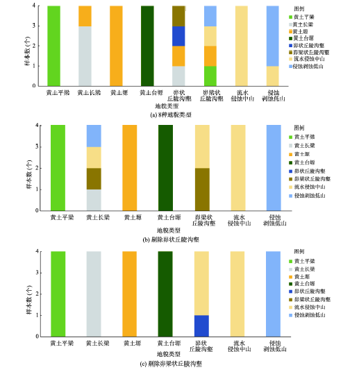
Fig. 5 Stacked column charts indicating the result of automatic landform recognition图5 地貌类型识别结果堆积柱状图 |
Tab. 2 Quantitative indicators of slope spectrum表2 坡谱特征量化指标 |
| 地貌类型 | 坡谱平均值 | 坡谱标准差 | 坡谱偏度 | 终止坡度(°) | 坡谱信息熵 | 斑块密度 |
|---|---|---|---|---|---|---|
| 峁梁状丘陵沟壑 | 23.48-25.81 | 9.35-10.34 | -0.29- -0.11 | 18~20 | 2.56-2.62 | 639-702 |
| 峁状丘陵沟壑 | 22.30-26.83 | 9.85-10.34 | -0.41-0.003 | 16~19 | 2.47-2.51 | 673-745 |
| 黄土平梁 | 22.01-24.93 | 10.40-11.20 | -0.45- -0.25 | 17~19 | 2.61-2.64 | 681-731 |
| 黄土长梁 | 23.26-25.26 | 8.93-9.55 | -0.44- -0.35 | 16~17 | 2.47-2.53 | 640-715 |
| 黄土塬 | 15.57-19.27 | 11.49-12.78 | 0.06-0.39 | 16~18 | 2.48-2.64 | 473-551 |
| 黄土台塬 | 5.87-11.29 | 7.35-10.30 | 0.89-2.14 | 15~17 | 1.43-2.27 | 171-441 |
| 侵蚀剥蚀的黄土低山 | 18.10-19.62 | 6.81-8.19 | -0.22- -0.006 | 14~15 | 2.25-2.38 | 407-463 |
| 流水侵蚀的中山 | 26.14-28.90 | 8.98-10.73 | -0.63- -0.45 | 18~21 | 2.48-2.64 | 558-665 |
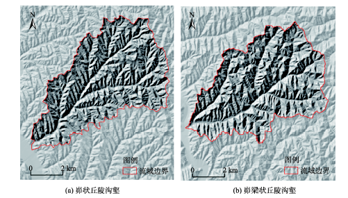
Fig. 6 Hillshade comparison figures between Loess Hilly-gully and Loess Hill-ridge图6 峁状丘陵沟壑和峁梁状丘陵沟壑光照晕渲对比图 |
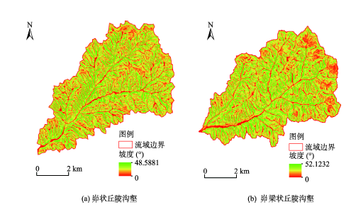
Fig. 7 Slope comparison figures between Loess Hilly-gully and Loess Hill-ridge图7 峁状丘陵沟壑和峁梁状丘陵沟壑坡度对比 |
Tab. 3 Recognition accuracy of each landform表3 每种地貌类型的正确识别率 |
| 实验编号 | 实验样区 | 黄土平梁(%) | 黄土长梁(%) | 黄土塬(%) | 黄土台塬(%) | 峁状丘陵沟壑(%) | 峁梁状丘陵沟壑(%) | 流水侵蚀中山(%) | 侵蚀剥蚀低山(%) |
|---|---|---|---|---|---|---|---|---|---|
| 1 | 8种地貌类型区 | 100 | 75 | 100 | 100 | 25 | 0 | 100 | 75 |
| 2 | 7种地貌类型区 (无峁状丘陵沟壑) | 100 | 25 | 100 | 100 | 50 | 100 | 100 | |
| 3 | 7种地貌类型区 (无峁梁状丘陵沟壑) | 100 | 100 | 100 | 100 | 25 | 100 | 100 |
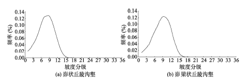
Tab. 4 Quantitative indicators of slope spectrum for Loess Hilly-gully and Loess Hill-ridge表4 峁状丘陵沟壑和峁梁状丘陵沟壑坡谱特征量化指标 |
| 地貌类型 | 坡谱信息熵 | 坡谱平均值 | 坡谱标准差 | 坡谱偏度 | 终止坡度 | 斑块密度 |
|---|---|---|---|---|---|---|
| 峁状丘陵沟壑 | 2.48 | 26.83 | 10.34 | -0.21 | 16 | 716 |
| 峁梁状丘陵沟壑 | 2.56 | 24.75 | 9.53 | -0.29 | 17 | 690 |
Tab. 5 The accuracy of automatic landform recognition表5 地貌类型识别的算法精度 |
| 识别样区 | Kappa系数(%) |
|---|---|
| 8种地貌类型区 | 67.9 |
| 7种地貌类型区(无峁状丘陵沟壑) | 87.1 |
| 7种地貌类型区(无峁梁状丘陵沟壑) | 87.5 |
Fig. 8 Slope spectrum comparison figures between Loess Hilly-gully and Loess Hill-ridge图8 峁状丘陵沟壑和峁梁状丘陵沟壑坡谱曲线图 |
The authors have declared that no competing interests exist.
| [1] |
|
| [2] |
|
| [3] |
|
| [4] |
|
| [5] |
|
| [6] |
|
| [7] |
|
| [8] |
|
| [9] |
|
| [10] |
|
| [11] |
|
| [12] |
|
| [13] |
|
| [14] |
|
| [15] |
|
| [16] |
|
| [17] |
|
| [18] |
|
| [19] |
|
| [20] |
|
| [21] |
|
| [22] |
|
| [23] |
|
| [24] |
|
| [25] |
|
| [26] |
|
| [27] |
|
| [28] |
|
| [29] |
|
| [30] |
|
/
| 〈 |
|
〉 |