全球卫星气候遥感数据

基于背景知识的全球长时间序列反照率反演

  • 商荣 1, 2 ,
  • 刘荣高 , 1, * ,
  • 刘洋 1
展开
  • 1. 中国科学院地理科学与资源研究所 资源与环境信息系统国家重点实验室,北京 100101
  • 2. 中国科学院大学,北京 100049
*通讯作者:刘荣高(1970-),研究员,博士,研究方向为定量遥感。E-mail:

作者简介:商 荣(1990-),男,湖北武汉人,博士生,研究方向为定量遥感。E-mail:

收稿日期: 2015-03-06

  要求修回日期: 2015-05-27

  网络出版日期: 2015-11-10

基金资助

气象行业科研专项(GYHY201106014)

中国科学院战略性先导科技专项(XDA05090303)

国家自然科学基金项目(41171285、41301354)

Generation of Global Long-term Albedo Product Based on the Background Knowledge

  • SHANG Rong 1, 2 ,
  • LIU Ronggao , 1, * ,
  • LIU Yang 1
Expand
  • 1. State key Laboratory of Resources and Envionmental Information system, Institute of Geographic Sciences and Natural Resources Research, CAS, Beijing 100101, China
  • 2. University of Chinese Academy of Sciences, Beijing 100049, China
*Corresponding author: LIU Ronggao, E-mail:

Received date: 2015-03-06

  Request revised date: 2015-05-27

  Online published: 2015-11-10

Copyright

《地球信息科学学报》编辑部 所有

摘要

全球范围时空连续的长时间序列地表反照率,对气候模拟与陆面过程研究具有重要意义。针对现有地表反照率产品普遍存在大量的数据缺失、有效反演比例低和时间序列短的问题,本文以多年MODIS和AVHRR数据,通过构建背景知识库进行高时间分辨率的AVHRR和MODIS数据的BRDF参数反演,实现MODIS与AVHRR数据在像元尺度上的定量融合,生成了全球时空连续长时间序列的地表反照率产品。首先,通过假设不同年份同一时期的地表状态不变,利用多年同一时期的MODIS和AVHRR观测数据构造多角度方向反射率,基于BRDF模型反演得到窄波段反照率;然后,通过宽波-窄波转换,得到MODIS的宽波段反照率;最后,结合AVHRR长时间序列优势及MODIS数据多光谱的特点,对二者进行定量融合,生成具有高度一致性长时间序列地表反照率产品。验证结果表明,本文地表反照率产品在地表异质性较小时与SURFRAD地面实测反照率之间具有非常好的一致性,在无积雪覆盖时与MODIS反照率产品之间吻合良好。本文的地表反照率产品无时空缺失,且时间覆盖率得到了极大的提高,能支持气候模式模拟与陆面过程模型进行近30 a来的地气系统模拟研究。

本文引用格式

商荣 , 刘荣高 , 刘洋 . 基于背景知识的全球长时间序列反照率反演[J]. 地球信息科学学报, 2015 , 17(11) : 1313 -1322 . DOI: 10.3724/SP.J.1047.2015.01313

Abstract

Global continuous long-term surface albedo products are of great importance to land surface process and climate modeling research. Problems such as severe data missing and low effective retrieval percentage in the current albedo products made them difficult to meet the requirements of climate modeling perfectly. To solve those problems, this paper made two improvements on MODIS albedo product algorithm. One improvement was to modify the way of composing and selecting enough directional reflectance, which were used for the generation of background BRDF parameters. We assumed that the surface would change little in the same time period during different years. Therefore, all directional reflectance of multi-years for each time period could be used for the composition and selection, in which at least 7 valid directional reflectance for each pixel were used to conduct the BRDF retrieval. Another improvement was the quantitative data fusion between MODIS and AVHRR data, which helped to expand the temporal coverage of albedo products to 30 years. Validation results showed that this new albedo product kept great consistency with the relatively homogeneous SURFRAD site albedos and was almost the same with MODIS snow-free albedo product. These were no spatial or temporal data missing in this new albedo product and the temporal coverage had been greatly improved. Therefore, this new albedo product would be more suitable for the applications of land surface process and climate modeling research.

1 引言

地表反照率(Surface Albedo)为地表反射的太阳辐射与入射太阳辐射的比值,可量化陆地表面与大气之间的辐射测量关系,定义了大气辐射传输的下边界[1],是制约陆面辐射能量收支平衡[2]和气候变化研究[3]的关键因子,对气候模拟与陆面过程研究都有着重要的意义。它常被用来分析城市的热岛效应[4],估算当地的大气温度[5],识别植被的结构类型[6],以及计算土壤湿度[7-8]
气候模拟与陆面过程研究,不仅需要全球尺度的地表反照率产品,还需保证产品的可靠性及时间和空间覆盖度的完整性。利用遥感可获取全球长时间序列的地表反照率,目前已经生产了多个地表反照率产品:历史反照率产品(如AVHRR[9-11]和ERBE[12])、星载反照率产品(如MODIS[13]、MISR[14]、POLDER[15-16]、Meteosat[17])、长时间序列反照率产品(如GLASS[18]等)。这些产品大都基于双向反射分布函数模型(BRDF)反演得到,这类反演算法的关键是假设方向反射率的分布符合某种BRDF模型,利用多角度的方向观测数据,反演得到BRDF模型参数,进而通过积分得到地表反照率。因此,反演得到的BRDF模型参数,决定了反照率产品的可用性和可靠性。
不同遥感产品根据其传感器的特点,选定某种角度分布模型,构造有效方向反射率用来反演BRDF模型参数。MODIS反照率产品假设16 d周期内的地表状态不变,根据16 d周期内Terra和Aqua不同时刻离散的方向观测获得多角度观测数据,有效方向观测数目至少为7,根据RossThick-LiSparse-R模型[19-22],利用最小二乘拟合法进行完全反演得到模型参数[13];在3-7个之间则利用辅助BRDF数据[10]进行部分反演;少于3个则不进行反演,从而造成数据缺失。对于MISR和POLDER等多角度传感器,利用其多角度方向观测数据,MISR和POLDER反照率产品分别基于半经验RPV模 型[23-24]和RossThick-LiSparse-R模型,通过最小二乘法拟合得到模型参数。但是,由于受到云等噪音的影响,大部分产品无法获得足够的有效方向反射率,导致反照率产品存在时间和空间不同程度的数据缺失。例如,分幅为H11V04的2005年MODIS反照率产品数据缺失的比例最高达64.57%,2005年4月第1天的MISR每日反照率产品存在74.27%的数据缺失等。时间和空间的数据缺失使得这些反照率产品的应用受到极大的限制。
本文基于AVHRR和MODIS的多年观测,通过构建背景知识库提出了一种新的地表反照率反演算法,解决了反照率产品有效反演比例低的问题。算法假设多年同一时段内地表状态不变,利用多年同一时期的MODIS和AVHRR观测数据约束构造多角度方向反射率,在像元尺度上确保BRDF模型反演所必须的至少7个方向反射率,从而实现了反照率产品的时空无缺失。另外,通过结合AVHRR长时间序列优势及MODIS数据多光谱的特点,实现了二者的定量融合,最终反演得到时空完整的全球长时间序列地表反照率产品。

2 研究数据与方法

2.1 数据源

本文采用AVHRR和MODIS地表反射率数据反演地表反照率。MOD09提供了2000年以来每日的地表方向反射率,空间分辨率为500 m,采用正弦投影(Sinusoidal Projection)。中国气象局提供了1982年以来AVHRR每天、1 km分辨率的地表反射率数据,为了与MODIS保持一致,本文利用最邻近像元法将AVHRR反射率数据采样到500 m,然后转换为正弦投影。
验证数据采用了SURFRAD地面观测数据和MODIS反照率产品MCD43。SURFRAD网站提供了10个地面站点的辐射数据,本文选用了2000年以前有观测数据的长时间覆盖站点:Bondville站点(40.05°N, 88.37°W,简写为BON)、Goodwin Creek站点(34.25°N,89.87°W,简写为GWN)、Fort Peck(48.31°N,105.10°W,简写为FPK)和Penn State站点(40.72°N,77.93°W,简写为PSU),便于同时验证AVHRR和MODIS数据反演的结果。根据地面观测的上行辐射通量和下行辐射通量,计算观测站点的地表反照率。MCD43B3产品提供了7个窄波段和3个宽波段的白空反照率和黑空反照率。真实地表反照率根据漫射比率,对白空和黑空反照率进行线性插值得到。采用MCD43B2质量控制数据统计有效反演比例,以及判断是否有积雪覆盖。

2.2 反演方法

基于MODIS和AVHRR地表反射率数据,本文通过4个步骤反演1982-2011年的长时间序列反照率产品(图1),算法的创新之处在于有效方向反射的构造与约束,以及AVHRR和MODIS数据的定量融合2个方面。
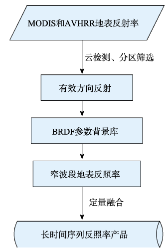
Fig. 1 Flow chart of long time series albedo retrieval

图1 长时间序列地表反照率产品反演流程图

(1)有效方向反射的构造与约束
MODIS地表反照率产品MCD43采用的完全反演算法需7个有效方向反射率,是由16 d周期内的地表反射率构成。由于受到云等噪音的影响,往往无法获得足够的方向观测数据进行完全反演。针对这个问题,本文提出了新的有效方向反射率的构造方式,以确保算法所必需的7个有效方向反射率。假设多年同一时段内地表状态不变,分别利用1982-2003年AVHRR和2000-2011年MODIS的多年观测,构造BRDF参数反演所必需的至少7次方向观测数据。对于AVHRR数据,22年间每个8 d时段内最多有176(22×8)个AVHRR方向观测;对于MODIS数据,2000年以来的Terra和2002年以来的Aqua卫星在每个8 d时段内最多可提供176(12×8+10×8)个MODIS方向观测。这种构造方式可保证每一个像元都有足够多的有效观测进行BRDF参数反演,从而保证了最终地表反照率数据的无缺失。为了提高BRDF参数反演的精度,本文对方向反射率进行2层约束:通过云检测算法[25]进行筛选;对方向进行分区筛选。BRDF参数反演需以有限的离散方向拟合整个半球空间,方向反射率越分散,拟合效果越好。为了确保构造的方向反射率具有足够的分散性,本文以10°为单位对太阳天顶角、观测天顶角和相对方位角进行分区,根据各个方向的分布区间对同时段内的方向观测数据进行筛选,分布集中的区间保留1~2个最佳方向,分布最为分散的区间由于个数少则全部保留。
(2)BRDF参数背景库的建立
本文采用半经验核驱动RossThick-LiSparse-R模型描述地表的二向反射特征(式(1))。对每个像元基于AVHRR和MODIS多年观测得到的有效方向观测,采用最小二乘法拟合不同波段的BRDF模型参数,分别建立AVHRR和MODIS BRDF模型参数背景库。
ρ ( θ , ϑ , ϕ ) = f iso + f vol K vol ( θ , ϑ , ϕ ) + f geo K geo ( θ , ϑ , ϕ ) (1)
式中, θ ϑ ϕ 分别是太阳天顶角、观测天顶角和相对方位角; ρ ( θ , ϑ , ϕ ) 是角度为 θ ϑ ϕ 的地表方向反射率; f iso f vol f geo 是BRDF模型参数; K vol ( θ , ϑ , ϕ ) K g eo ( θ , ϑ , ϕ ) 分别是辐射传输核[20]和几何光学核[22]
(3)窄波段地表反照率的反演
对于任意时段角度为 θ ϑ ϕ 的MODIS和AVHRR观测方向反射率 ρ obs ( θ , ϑ , ϕ ) ,基于BRDF模型参数背景库反演该角度的参考方向反射率,通过观测方向反射率与参考方向反射率的比值,将窄波段参考反照率 α ref 校正为该时段的窄波段反照率 α (式(2))。窄波段参考反照率根据漫射比例 r_d 对白空反照率 α ws 和黑空反照率 α bs 进行线性组合得到(式(3))。漫射比例采用经验公式根据太阳天顶角的余弦值 μ 0 计算(式(4))。白空反照率和黑空反照率由BRDF模型背景参数通过角度积分计算[13]
α = ρ obs ( θ , ϑ , ϕ ) f iso + f vol K vol ( θ , ϑ , ϕ ) + f geo K geo ( θ , ϑ , ϕ ) × α ref (2)
α ref = ( 1 - rd ) × α bs + rd × α ws (3)
r_d = 0.122 + 0.85 exp ( - 4.8 μ 0 ) (4)
(4)AVHRR和MODIS数据的定量融合
基于窄波段反照率线性组合的方法计算2000年以来的MODIS宽波段反照率,利用MODIS红、近红外和绿波段反照率转换得到可见光波段反照率,利用红、近红、蓝、绿和短波红外波段反照率转换得到近红外波段反照率,并采用红、近红、蓝、绿、短波红外波段反照率转换得到短波波段反照率[26]
利用2000-2003年2个传感器的重复观测建立AVHRR红波段和近红外波段窄波段反照率( α AVHRR , Re d α AVHRR , NIR )与MODIS宽波段反照率 A MODIS , Λ 像元级的关系:
A MODIS , Λ = p 0 , Λ α AVHRR , Red + p 1 , Λ α AVHRR , NIR + p 2 , Λ (5)
式中, Λ 为红波段、近红外和短波红外宽波段; p 0 , Λ p 1 , Λ p 2 , Λ 为拟合关系系数。对于红波段、近红外和短波红外波段,分别拟合每个像元的3个 参数。在此基础上,利用1982-1999年AVHRR红波段和近红外窄波段反照率,由式(5)得到1982-1999年的AVHRR宽波段反照率,最终获得AVHRR 和MODIS高一致性的长时间序列地表宽波段反 照率。

3 全球长时间序列反照率反演结果分析

3.1 反演的结果

本文以AVHRR数据反演得到1982-1999年地表反照率,以MODIS数据反演得到2000-2011年地表反照率(图2)。图2(a)和图2(c)是以MODIS数据生产的2008年177 d、305 d地表反照率;图2(b)和图2(d)是以AVHRR数据反演的1982年177 d、305 d地表反照率。177 d和305 d分别是北半球夏季和冬季,南半球正好相反。对于夏季,地表反照率具有明显地理分布规律,全球大部分区域地表反照率在0.26以下,较高的反照率分布在非洲、亚洲和大洋洲的沙漠区域,最大的地表反照率出现在终年积雪区域(如高山积雪区和高纬度积雪区)。夏季太阳天顶角接近最低时,MCD43等地表反照率产品在时间和空间上的缺失主要由云造成,而本文反照率产品没有出现较高的异常值及数据缺失,对云的影响具有很好的鲁棒性。基于AVHRR数据反演的夏季地表反照率与MODIS数据反演的夏季地表反照率具有很好的时空连续性。对于冬季,北半球高纬度非终年积雪覆盖区域出现积雪覆盖,地表反照率明显高于夏季;无积雪覆盖的区域地表反照率低于0.26,整体与夏季地表反照率保持一致。AVHRR数据反演的冬季地表反照率与基于MODIS数据反演的冬季地表反照率,在无积雪覆盖时具有很好的时空连续性。
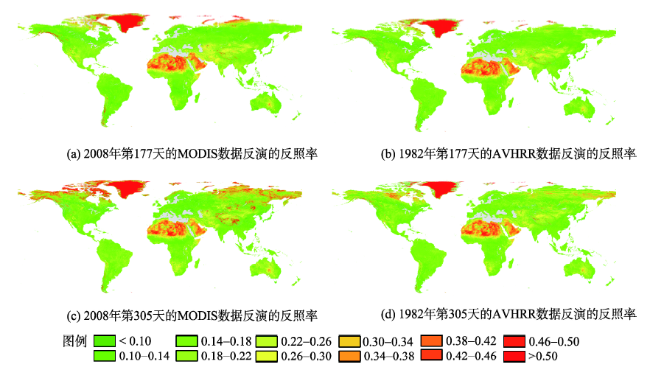
Fig. 2 Results of the surface albedo products in this paper

图2 本文地表反照率产品反演结果图

3.2 反演比例

表1描述了分幅为H11V04的MODIS反照率产品(MCD43)2005年的完全反演比例、部分反演比例和缺失比例。完全反演是指有效方向反射率至少有7个时,基于BRDF模型进行的反演。部分反演指当有效方向反射率在3-7个之间时,根据辅助BRDF数据[10]进行的反演。从表1可看出,MCD43反照率2005年全年完全反演比例的平均值为49.81%,并且随着时间推移,完全反演比例表现出先升高后降低的趋势,夏季和秋季的完全反演比例高,春季和冬季的完全反演比例低,最低的时候仅有0.18%。本文算法采用了与MODIS反照率反演算法相同的BRDF模型,但是由于改善了有效方向反射的构造方式,在像元尺度上确保BRDF模型反演所必须的至少7次方向反射,实现了所有像元的完全反演,因而有效反演比例远远高于MODIS地表反照率产品。
Tab. 1 Inversion ratios of MODIS albedo products in 2005

表1 2005年MODIS反照率产品的反演比例

时间 完全反演(%) 部分反演(%) 缺失(%) 时间 完全反演(%) 部分反演(%) 缺失(%)
第1天 1.66 59.58 38.75 第185天 77.58 22.38 0.04
第9天 1.36 68.75 29.89 第193天 75.45 24.51 0.05
第17天 2.03 72.93 25.04 第201天 85.09 14.88 0.03
第25天 9.93 72.48 17.60 第209天 84.42 15.57 0.00
第33天 12.98 68.39 18.63 第217天 77.54 22.43 0.03
第41天 11.93 58.61 29.47 第225天 79.96 20.03 0.00
第49天 17.13 61.50 21.37 第233天 87.88 12.12 0.00
第57天 21.55 63.42 15.03 第241天 87.98 12.02 0.00
第65天 18.18 55.87 25.96 第249天 90.40 9.59 0.01
第73天 14.27 70.03 15.70 第257天 91.00 9.00 0.00
第81天 52.30 46.50 1.20 第265天 86.41 13.57 0.03
第89天 84.07 15.87 0.06 第273天 85.99 13.86 0.15
第97天 88.45 11.55 0.00 第281天 81.60 18.30 0.11
第105天 73.00 26.95 0.05 第289天 81.30 18.57 0.13
第113天 75.12 24.76 0.13 第297天 67.19 32.33 0.48
第121天 68.88 31.00 0.12 第305天 38.36 55.59 6.05
第129天 39.78 53.07 7.15 第313天 30.35 57.30 12.35
第137天 55.06 42.15 2.79 第321天 9.45 51.44 39.11
第145天 36.85 57.79 5.37 第329天 0.20 47.21 52.59
第153天 46.80 52.70 0.49 第337天 1.00 58.88 40.12
第161天 78.14 21.78 0.08 第345天 2.21 65.21 32.58
第169天 84.46 15.53 0.01 第353天 0.40 48.89 50.71
第177天 75.24 24.76 0.00 第361天 0.18 35.25 64.57

3.3 算法适用性分析

针对地表反照率反演算法中不同年份同一时期地表状态不变的假设,本文做了全球适用性分析。图3为基于1982-1999年AVHRR数据、2000-2011年MODIS数据反演的时间序列反照率均方根误差分布图,分别采用第177-184天和第305-312天的2个8 d代表夏季和冬季的状况。均方根误差越小,地表状态的变化越小,则本文的假设越可信。图3表明夏季反照率在多年内较稳定,均方根误差多在0.02以下,说明算法假设适用性良好。变化较大的区域主要分布在北纬高纬度地区和南美、亚洲高山区。与夏季相比,冬季地表状况不变假设的不适用区域增多,北纬中高纬度地区都出现了较大的均方根误差(图3(b)、(d))。这些区域在冬季会出现积雪覆盖与非积雪覆盖共存的情况,导致算法的假设不适用。南半球冬季(图3(a)、(c))误差较大的区域相对夏季也增多,但均方根误差多在0.05以内。本文还对图3的均方根误差分南北半球进行了统计(图4),并计算了南北半球的平均值。对于AVHRR数据反演的地表反照率,夏季全球有98.74%区域的均方根误差小于0.05,冬季全球有92.74%区域的均方根误差小于0.05;对于MODIS数据反演的地表反照率,夏季全球有95.98%区域的均方根误差小于0.05,冬季全球有82.34%区域的均方根误差小于0.05。上述统计表明,本文算法的假设在夏季时几乎全球适用,在冬季对北半球中低纬度地区及南半球适用,不适用的区域主要分布在北半球中高纬度季节性积雪区,以及高山季节性积雪区。
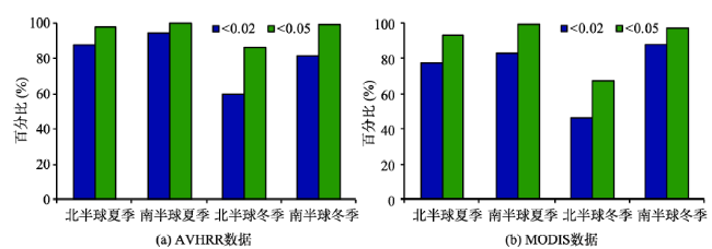
Fig. 3 Global applicability analysis of the surface albedo products in this paper

图3 本文地表反照率算法适用性分析全球分布图

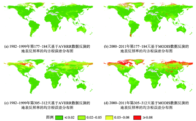
Fig. 4 Statistics of the RMSE based on time series surface albedo

图4 时间序列反照率均方根误差的统计图

3.4 结果验证与评价

本文采用独立的野外观测数据,对AVHRR数据和MODIS数据的反演结果进行验证,并通过与MODIS地表反照率标准产品对比,对反演结果进行评价。
3.4.1 与地面观测数据对比
本文采用SURFRAD野外观测数据进行地面验证,利用1998年和1999年的站点数据评价AVHRR数据反演的反照率,利用2011年的站点数据评价MODIS数据反演的反照率。地面观测数据一般与遥感卫星数据之间存在较大的尺度差距,对于异质性较小的地面,可用一个站点观测值来代表整个区域,和遥感产品的比较也更加合理。本文采用半方差[27]及其球型模拟公式[28],对地表异质性进行描述,式中较小的C值(sill value)代表着较小的地表异质性[28]。根据Landsat数据计算了BON、GWN、FPK和PSU的4个季节的C值,4个站点所选年份总共32个C值均不超过0.005,表明所选站点的地表异质性较小,地面观测反照率可直接与本文地表反照率进行对比验证。
图5、6分别展示了本文基于AVHRR数据反演的反照率及MODIS数据反演的地表反照率与SURFRAD地面观测反照率之间的对比结果。在无积雪覆盖的情况下,本文反照率产品与SURFRAD地面反照率之间具有很好的一致性,特别是夏季的地表反照率。对于BON站点,与SURFRAD反照率相比,本文反照率产品在春季偏低,无积雪覆盖时基于AVHRR数据反演的反照率偏差为-0.029,基于MODIS数据反演的反照率偏差为-0.020。BON站点地表覆盖类型是耕地,春季播种阶段土地性质近似于裸土,反照率偏低可能是由裸土反照率与植被反照率之间的差异所引起;随着植被生长,地表植被覆盖度增大,异质性减小,本文反照率产品与地面观测反照率之间的差异也逐渐减小。对于GWN站点,所选年份均无积雪覆盖,本文反照率与地面观测反照率之间具有很好的一致性,基于AVHRR数据和MODIS数据反演的反照率偏差均较小(表2)。对于FPK站点和PSU站点,无积雪覆盖时基于AVHRR数据和MODIS数据反演的反照率偏差均较小(表2),冬季积雪覆盖时出现较大的差异。这些差异主要是:(1)积雪反照率与非积雪反照率之间的差异,本文反照率反演算法在部分时段积雪覆盖条件下,会排除积雪覆盖的观测数据,所以描述的是非积雪反照率,而SURFRAD描述的是积雪反照率,从而导致了SURFRAD反照率远大于本文反照率的现象;(2)积雪反照率与积雪反照率之间的差异,如FPK站点2011年041-065 d,雪的粒子直径、密度、含水量和所含杂质等物理属性都会影响地表反照率。本文算法检测的是8 d时段内的反照率,SURFRAD检测的是当日反照率,会出现新雪与旧雪、降雪与融雪等差异,所以,会表现出较大的差异与不确定性。
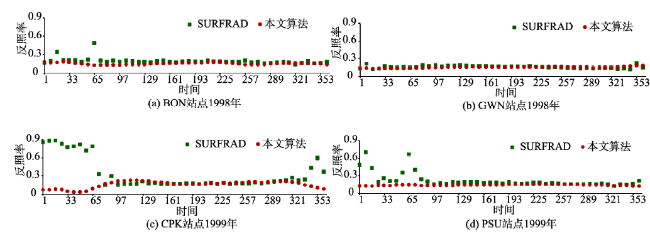
Fig. 5 Comparison of the time series of SURFRAD site albedo and surface albedo based on AVHRR data

图5 基于AVHRR数据反演的反照率与SURFRAD地面观测反照率的时间序列对比图

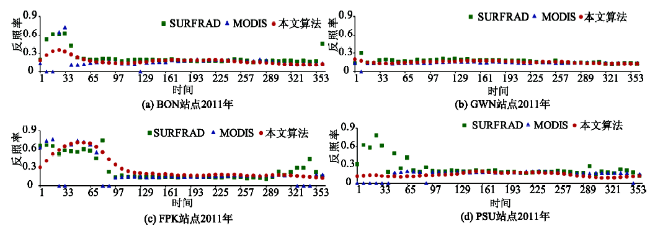
Fig.6 Comparison of the time series of SURFRAD site albedo, MCD43 surface albedo and surface albedo based on MODIS data

图6 基于MODIS数据反演的反照率、MCD43地表反照率与SURFRAD地面观测反照率的时间序列对比图

表2描述了利用SURFRAD站点反照率验证本文基于AVHRR数据和MODIS数据反演的反照率的精度结果,统计中去掉了部分积雪覆盖的情况,以及MODIS反照率产品数据缺失的情况。4个站点所选年份的均方根误差都在0.05以内,满足气候模式对反照率精度±0.05的要求[29]。4个站点基于AVHRR数据反演的反照率与MODIS数据反演的反照率的均方根误差十分接近,表明本文基于AVHRR数据和MODIS数据反演的反照率之间,具有很好的连续性。
Tab. 2 Validation accuracies based on SURFRAD site albedo

表2 地表反照率地面验证精度

反照率 BON站点 GWN站点 FPK站点 PSU站点
BIAS RMSE BIAS RMSE BIAS RMSE BIAS RMSE
基于AVHRR的反照率 -0.029 0.036 -0.006 0.025 0.002 0.032 -0.032 0.042
基于MODIS的反照率 -0.020 0.032 -0.012 0.024 0.018 0.039 -0.033 0.049
MCD43地表反照率 -0.020 0.038 -0.016 0.027 0.006 0.020 -0.012 0.031
3.4.2 与MODIS产品的初步比较
基于SURFRAD 4个站点,本文将MODIS地表反照率(MCD43)与MODIS数据反演的地表反照率进行了比较(图6)。MCD43地表反照率在4个站点均存在数据缺失的情况,缺失的数据在图6中以0值表示。无积雪覆盖时,本文反照率产品与MCD43反照率产品整体上表现出非常好的一致性。表2描述了利用SURFRAD地面站点反照率验证MCD43地表反照率,以及基于MODIS数据所反演的反照率的对比结果。验证精度统计中去掉了MCD43地表反照率数据缺失的情况。对于BON站点与GWN站点,本文反照率的偏差与均方根误差均小于MCD43反照率;对于FPK站点和PSU站点,本文地表反照率的偏差与均方根误差大于MCD43地表反照率,与图6时间序列的描述结果一致。
为了更客观地对比MODIS数据反演的地表反照率与MCD43反照率,本文选用了2005年第177天分幅为H11V04和H26V04的2景数据来进行像元尺度上的对比。图7描述的是本文反照率产品与MCD43反照率产品的散点图,分幅分别为H11V04和H26V04,时间均为2005年第177天;图8是与图7对应的差值图,MCD43反照率产品中的缺失数据在图8中以深蓝色表示。图7图8表明本文反照率与MCD43反照率产品之间具有非常好的一致性,差值几乎全部保持在±0.05的范围内,超出±0.05的像元所占比例小于1%,超出±0.1的像元所占比例小于0.1%。从图8可看出,MCD43反照率产品存在着较多的数据缺失,本文算法由于改善了有效方向反射率的构造方式,在像元尺度上确保BRDF模型反演所必须的至少7个方向反射率,实现了像元尺度上的完全反演,因而不存在数据缺失的情况。
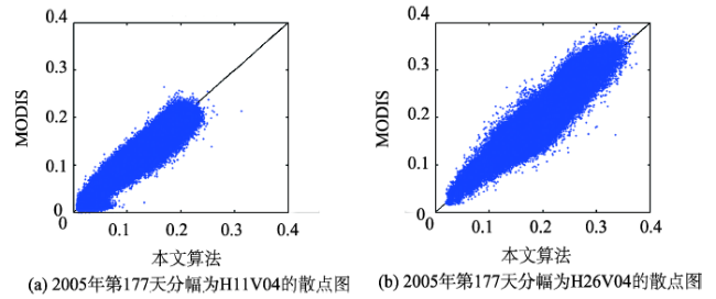
Fig. 7 Scatterplots between algorithm-based albedo and MODIS albedo (MCD43)

图7 本文反照率产品与MODIS反照率产品(MCD43)的散点图

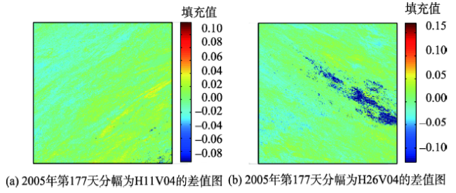
Fig. 8 Difference images between algorithm-based albedo and MODIS albedo (MCD43)

图8 本文反照率产品与MODIS反照率产品(MCD43)的差值图

4 讨论

本文通过改善有效方向反射的构造和约束方式,在像元尺度上确保BRDF模型反演所必需的至少7个方向反射率,从而实现了反照率产品的时空无缺失;通过与AVHRR数据的定量融合,将反照率的时间覆盖度扩展到30 a。但是,本文算法还存在一些不确定性与不足:
(1)部分积雪覆盖带来的不确定性。积雪覆盖与非积雪覆盖之间,地表反照率的差异特别大,如果该时段内不全是积雪覆盖,利用非积雪覆盖反照率代表该时段的反照率会导致较大的不确定性。这种部分积雪覆盖的情况主要分布在北半球中高纬度季节性积雪区及高山季节性积雪区。本文算法在部分积雪覆盖时反演获得的是非积雪地表反照率,在质量控制数据(QC)中,对部分积雪覆盖情况下反演的地表反照率进行了标记。用户在使用本数据集时需要考虑这些标记。
(2)不同年份同一时期地表状态不变的假设带来的不确定性。算法的全球适用性分析表明,该假设在夏季时几乎全球适用,在冬季对北半球中低纬度地区及南半球适用,不适用的区域主要分布在北半球中高纬度季节性积雪区及高山季节性积雪区。除了部分积雪造成的较大的地表差异外,其他不适用的区域很少。
(3)AVHRR和MODIS传感器之间的差异所带来的不确定性。相比于MODIS传感器,AVHRR在波段数目、定标精度上都存在着一定局限性,制约了其地表反照率的反演质量。本文通过数据融合技术,根据MODIS数据反演的地表反照率来矫正AVHRR数据地表反演的反照率,从而缩小了传感器之间的差异。结果分析表明,AVHRR数据反演的夏季反照率与MODIS数据反演的夏季反照率具有很好的一致性,冬季无积雪覆盖时,2种数据反演的反照率之间也具有很好的一致性。

5 结语

针对MODIS反照率产品中存在大量数据缺失、有效反演比例低的问题,本文以MODIS和AVHRR多年观测数据,通过构建背景知识库进行高时间分辨率的AVHRR和MODIS数据的BRDF参数反演,实现2个传感器数据在像元尺度上的定量融合,生成了1982-2011年全球时空连续的长时间序列地表反照率产品。通过假设不同年份同一时期的地表状态不变,利用多年同一时期的MODIS和AVHRR观测数据约束构造多角度方向反射率,基于BRDF模型反演得到窄波段反照率;然后,通过宽波-窄波转换,得到MODIS的宽波段反照率。通过结合AVHRR长时间序列优势及MODIS数据多光谱的特点,对二两者进行定量融合,生成具有高度一致性的长时间序列反照率产品。
本文生成的反照率产品优势主要体现在无时空缺失;另外,通过与AVHRR数据进行融合,完成了高时间分辨率历史反照率的反演,产品覆盖了有完整的全球连续观测以来的时间序列。验证结果表明,无积雪覆盖时本文反照率产品与SURFRAD地面反照率、MODIS反照率产品之间具有非常好的一致性。本文所生成的无积雪覆盖反照率及完全积雪覆盖反照率,可用于气候模式的模拟与陆面过程的研究,特别是长时间序列产品有助于气候变化的地表响应分析。将来的工作需对部分积雪覆盖情况下反照率的反演进行更细致地描述,通过提高反照率产品时间分辨率,或者提出专门的部分积雪覆盖情况下反照率反演算法来解决这个问题,从而使反照率产品更满足气候模式模拟与陆面过程研究的要求。

The authors have declared that no competing interests exist.

[1]
Hu B X, Lucht W, Strahler A H.The interrelationship of atmospheric correction of reflectances and surface BRDF retrieval: A sensitivity study[J]. IEEE Transactions on Geoscience and Remote Sensing, 1999,37(2Part 1):724-738.This paper systematically studies the interrelationship between surface bidirectional reflectance distribution function (BRDF) retrieval and atmospheric correction. The study uses the atmospheric correction scheme of the Moderate Resolution Imaging Spectroradiometer (MODIS) and angular sampling expected for MODIS and the Multiangle Imaging SpectroRadiometer (MISR) for different land cover types and optical depths of aerosols. The results show the following two points. 1) Even for a nonturbid atmosphere, the assumption of a Lambertian surface in atmospheric correction causes relative errors in the retrieved surface reflectances that average from 2 to 7% in the red and near-infrared bands, with worst cases showing errors of up to about 15% for turbid conditions. Consequently, it is necessary for improved accuracy to consider surface anisotropy in atmospheric correction. 2) Surface BRDF retrieval and atmospheric correction can be coupled in a converging iteration loop that improves the quality of atmospheric correction and subsequent BRDF retrievals. For example, performing two steps of the iteration loop is already sufficient to obtain mean relative errors of less than 1% in the retrieved surface reflectances even for an atmospheric aerosol optical depth of 0.4. As BRDF retrieval accuracies improve, so do bihemispherical albedo retrieval accuracies, with mean relative errors being 1-5% when using a Lambertian assumption and less than 1% after two iteration steps

DOI

[2]
Dickinson R E.Land surface processes and climate-surface albedos and energy balance[J]. Advances in Geophysics, 1983,25:305-353.This chapter provides an overview of land surface processes and climate-surface albedos, and attempts to bridge the gap between disciplinary studies of atmospheric versus surface climate. The chapter describes physical processes involving the land surface that are of concern to scientists interested in modeling the global climate system. It looks at the physics of land surface albedos by presenting a conceptual basis for understanding the basic concepts. Physical reasoning and simple mathematical models are used to summarize how these factors determine surface albedos. Some of the aspects of surface energy balance considerations that are important for global climate models are summarized. Factors that are important for determining the albedos and energy balance of land surfaces are also outlined. The mathematical theory of plant canopy albedos is presented, and a summary of parameters determining plant canopy albedo is provided. Concepts related to snow albedos, soil albedos, and surface albedos for climate models are discussed. Modeling temperature of a transpiring canopy, and modeling energy exchange over a snow surface are also described.

DOI

[3]
Feddema J J, Oleson K W, Bonan G B, et al.The importance of land-cover change in simulating future climates[J]. Science, 2005,310(5754):1674-1678.Adding the effects of changes in land cover to the A2 and B1 transient climate simulations described in the Special Report on Emissions Scenarios (SRES) by the Intergovernmental Panel on Climate Change leads to significantly different regional climates in 2100 as compared with climates resulting from atmospheric SRES forcings alone. Agricultural expansion in the A2 scenario results in significant additional warming over the Amazon and cooling of the upper air column and nearby oceans. These and other influences on the Hadley and monsoon circulations affect extratropical climates. Agricultural expansion in the mid-latitudes produces cooling and decreases in the mean daily temperature range over many areas. The A2 scenario results in more significant change, often of opposite sign, than does the B1 scenario.

DOI PMID

[4]
Menon S, Akbari H, Mahanama S, et al.Radiative forcing and temperature response to changes in urban albedos and associated CO2 offsets[J]. Environmental Research Letters, 2010,5(1):123-129.offsets would require simulations which better characterize urban surfaces and represent the full annual cycle.

DOI

[5]
Krayenhoff E S, Voogt J A.Impacts of urban albedo increase on local air temperature at daily-annual time scales: Model results and synthesis of previous work[J]. Journal of Applied Meteorology and Climatology, 2010,49(8):1634-1648.Abstract The authors combine urban and soil–vegetation surface parameterization schemes with one-dimensional (1D) boundary layer mixing and radiation parameterizations to estimate the maximum impact of increased surface albedo on urban air temperatures. The combined model is evaluated with measurements from an urban neighborhood in Basel, Switzerland, and the importance of surface–atmosphere model coupling is demonstrated. Impacts of extensive albedo increases in two Chicago, Illinois, neighborhoods are modeled. Clear-sky summertime reductions of diurnal maximum air temperature for the residential neighborhood ( λ p = 0.33) are 611.1°, 611.5°, and 613.6°C for uniform roof albedo increases of 0.19, 0.26, and 0.59, respectively; reductions are about 40% larger for the downtown core ( λ p = 0.53). Realistic impacts will be smaller because the 1D modeling approach ignores advection; a lake-breeze scenario is modeled and temperat

DOI

[6]
Gao F, Schaaf C B, Strahler A H, et al.Detecting vegetation structure using a kernel-based BRDF model[J]. Remote Sensing of Environment, 2003,86(2):198-205.The magnitude of the anisotropy of vegetation is mainly determined by its spectral and structural features. It can be described by the bidirectional reflectance distribution function (BRDF). The parameters of physical BRDF models are related to the biophysical structural information. However, for a semiempirical kernel-based BRDF model, the relationship between BRDF parameters and vegetation structure is no longer as clear as with a physical BRDF model. To reveal this relationship, a structural scattering index (SSI) and a relative structural scattering index (RSSI) are derived based on the BRDF parameters in this paper. The investigation of SSI and RSSI show that they have both theoretical and practical meaning and can be used to distinguish different land cover types or to detect structural changes.

DOI

[7]
Wilson M F, Henderson-Sellers A, Dickinson R E, et al.Sensitivity of the biosphere-atmosphere transfer scheme (BATS) to the inclusion of variable soil characteristics[J]. Journal of Climate and Applied Meteorology, 1987,26(3):341-362.The soils data of Wilson and Henderson-Sellers have been incorporated into the land-surface parameterization scheme of the NCAR Community Climate Model after Dickinson. A stand-alone version of this land-surface scheme, termed the Biosphere-Atmosphere Transfer Scheme (BATS), has been tested in a series of sensitivity experiments designed to assess the sensitivity of the scheme to the inclusion of variable soil characteristics. The cases investigated were for conditions designed to represent a low-latitude, evergreen forest; a low-latitude sand desert; a high-latitude coniferous forest; high-latitude tundra; and prairie grasslands, each for a specified time of year. The tundra included spring snowmelt and the grassland incorporated snow accumulation. The sensitivity experiments included varying the soil texture from a coarse texture typical of sand through a medium texture typical of loam to a fine texture typical of clay. The sensitivity of the formation to the specified total and upper soil column depth and the response to altering the parameterization of the soil albedo dependence upon soil wetness and snow-cover were also examined. The biosphere-atmosphere transfer scheme showed the greatest sensitivity to the soil texture variation, particularly to the associated variation in the hydraulic conductivity and diffusivity parameters. There was only a very small response to more» the change in the soil albedo dependence on wetness and, although the sensitivity to the snow-covered soil albedo via the response to roughness length/snowmasking depth was significant, the results were predictable. Soil moisture responses can also be initiated by changes in vegetation characteristics such as the stomatal resistance through changed canopy interaction which modify the radiation and water budgets of the soil surface. 芦less

DOI

[8]
Dai Y J, Zeng X B, Dickinson R E, et al.The common land model[J]. Bulletin of the American Meteorological Society, 2003,84(8):1013-1023.

[9]
Strugnell N C, Lucht W, Schaaf C.A global albedo data set derived from AVHRR data for use in climate simulations[J]. Geophysical Research Letters, 2001,28(1):191-194.We present a global 1-km albedo dataset derived from Advanced Very High Resolution Radiometer (AVHRR) satellite remote sensing data, a global land cover classification and field observations of typical land surface bidirectional reflectance distribution functions (BRDFs). There is a clear need for such a global albedo map for use in atmospheric radiative transfer models. A land cover classification based on surface structure is employed and class correspondences used to generate a structural class map from an existing ecological global land classification. Representative field measurements of BRDF are assigned to each of the structural classes allowing us to retrieve BRDF shape parameters and albedo for each class using a semiempirical model. These parameters were adjusted using global AVHRR data to account for intra-class variations of surface reflectance. Albedos were calculated from the adjusted parameters and summarised by land cover type, continent and season.

DOI

[10]
Strugnell N C, Lucht W.An algorithm to infer continental-scale albedo from AVHRR data, land cover class, and field observations of typical BRDFs[J]. Journal of Climate, 2001,14(7):1360-1376.ABSTRACT A method to derive bottom-of-atmosphere land surface albedos from Advanced Very High Resolution Radiometer (AVHRR) satellite measurements is presented. The algorithm described uses kernel-based bi-directional reflectance distribution function (BRDF) models of land cover but, in contrast to other kernel-based albedo retrievals, assumes a priori knowledge of underlying surface BRDFs, based on a land cover classification and typical field-measured BRDFs for each class in the land cover classification. The BRDF of each land cover is scaled using AVHRR reflectance measurements to take into account within-class variations of albedo, and the resultant scaled BRDF is integrated to retrieve an albedo. An albedo dataset for North America is produced with this scheme from February and July 1995 monthly maximum normalized difference vegetation index value composite images. Spectral-to-broadband albedo conversion is achieved by using spectral albedos to scale a laboratory-measures vegetation spectral reflectance curve. Both white-sky (bihemispherical reflectance) and black-sky (directional-hemispherical reflectance) albedos are produced. The methodology presented is general and can be used with historical AVHRR. In addition it will be used with data from the moderate-resolution imaging spectrometer sensor aboard the Terra satellite as an ancillary technique to produce global, monthly albedo datasets for use in climatic and atmospheric research.

DOI

[11]
Csiszar I, Gutman G.Mapping global land surface albedo from NOAA AVHRR[J]. Journal of Geophysical Research: Atmospheres, 1999,104(D6):6215-6228.A set of algorithms is combined for a simple derivation of land surface albedo from measurements of reflected visible and near-infrared radiation made by the advanced very high resolution radiometer (AVHRR) onboard the National Oceanic and Atmospheric Administration (NOAA) polar orbiting satellites. The system consists of a narrowband-to-broadband conversion and bidirectional correction at the top of the atmosphere and an atmospheric correction. We demonstrate the results with 1 month worth of data from the NOAA National Environmental Satellite, Data, and Information Service (NESDIS) global vegetation index (GVI) weekly data set and the NOAA/NASA Pathfinder Atmosphere (PATMOS) project daily data. Error analysis of the methodology indicates that the surface albedo can be retrieved with 10–15% relative accuracy. Monthly albedo maps derived from September 1989 GVI and PATMOS data agree well except for small discrepancies attributed mainly to different preprocessing and residual atmospheric effects. A 5-year mean September map derived from the GVI multiannual time series is consistent with that derived from low-resolution Earth Radiation Budget Experiment data as well as with a September map compiled from ground observations and used in many numerical weather and climate models. Instantaneous GVI-derived albedos were found to be consistent with surface albedo measurements over various surface types. The discrepancies found can be attributed to differences in areal coverage and representativeness of the satellite and ground data. The present pilot study is a prototype for a routine real-time production of high-resolution global surface albedo maps from NOAA AVHRR Global Area Coverage (GAC) data.

DOI

[12]
Li Z, Garand L.Estimation of surface albedo from space: A parameterization for global application[J]. Journal of Geophysical Research: Atmospheres, 1994,99(D4):8335-8350.This study proposes a simple parameterization to derive surface broadband albedo from satellite observations, using the results of detailed radiative transfer computations for a variety of atmospheric and surface conditions. The end result is a single equation that directly yields surface albedo from observed albedo at the top of the atmosphere, solar zenith angle, and total precipitable water. It was demonstrated that the parameterization is valid for retrieval of both instantaneous and daily mean surface albedo. Sensitivity tests were conducted for precipitable water, aerosol, CO 2 , O 3 , and temperature profile. Preliminary validation using collocated satellite and tower measurements indicates that the absolute accuracy requirement of 5% for climate studies is well satisfied. A global monthly climatology (excluding polar areas) of surface albedo is then developed from 5 years of Earth Radiation Budget Experiment clear-sky satellite data and European Centre for Medium-Range Weather Forecasts humidity analysis data. Examination of month-to-month differences for specific 2.5掳脳2.5掳 areas indicate that the absolute random error on monthly estimates is less than 1%. Seasonal variation of surface albedo exceeding 1% can thus be detected. Comparisons with other satellite estimates show much closer agreement than with the values used in some general circulation models and numerical weather prediction models especially over snow/ice and deserts.

DOI

[13]
Lucht W, Schaaf C B, Strahler A H.An algorithm for the retrieval of albedo from space using semiempirical BRDF models[J]. IEEE Transactions on Geoscience and Remote Sensing, 2000,38(2):977-998.Spectral albedo may be derived from atmospherically corrected, cloud-cleared multiangular reflectance observations through the inversion of a bidirectional reflectance distribution function (BRDF) model and angular integration. This paper outlines an algorithm suitable for this task that makes use of kernel-based BRDF models. Intrinsic land surface albedos are derived, which may be used to derive actual albedo by taking into account the prevailing distribution of diffuse skylight. Spectral-to-broadband conversion is achieved using band-dependent weighting factors. The validation of a suitable BRDF model, the semiempirical Ross-Li (reciprocal RossThick-LiSparse) model and its performance under conditions of sparse angular sampling and noisy reflectances are discussed, showing that the retrievals obtained are generally reliable. The solar-zenith angle dependence of albedo may be parameterized by a simple polynomial that makes it unnecessary for the user to be familiar with the underlying BRDF model. The algorithm given is that used for the production of a BRDF/albedo standard data product from NASA's EOS-MODIS sensor, for which an at-launch status is provided. Finally, the algorithm is demonstrated on combined AVHRR and GOES observations acquired over New England, from which solar zenith angle-dependent albedo maps with a nominal spatial resolution of 1 km are derived in the visible band. The algorithm presented may be employed to derive albedo from space-based multiangular measurements and also serves as a guide for the use of the MODIS BRDF/albedo product.

DOI

[14]
Diner D J, Beckert J C, Reilly T H, et al.Multi-angle Imaging SpectroRadiometer (MISR) instrument description and experiment overview[J]. IEEE Transactions on Geoscience and Remote Sensing, 1998,36(4):1072-1087.The Multi-angle Imaging SpectroRadiometer (MISR) instrument is scheduled for launch aboard the first of the Earth Observing System (EOS) spacecraft, EOS-AM1. MISR will provide global, radiometrically calibrated, georectified, and spatially coregistered imagery at nine discrete viewing angles and four visible/near-infrared spectral bands. Algorithms specifically developed to capitalize on this measurement strategy will be used to retrieve geophysical products for studies of clouds, aerosols, and surface radiation. This paper provides an overview of the as-built instrument characteristics and the application of MISR to remote sensing of the Earth

DOI

[15]
Leroy M, Deuze J L, Breon F M, et al.Retrieval of atmospheric properties and surface bidirectional reflectances over land from POLDER/ADEOS[J]. Journal of Geophysical Research-Atmospheres, 1997,102(D14):17023-17037.Polarization and Directionality of the Earth's Reflectances (POLDER) is a new instrument devoted to the global observation of the polarization and directionality of solar radiation reflected by the Earth-atmosphere system. It will fly onboard the ADEOS platform in 1996. This paper outlines the improvements expected from POLDER in the description of atmospheric aerosols and water vapor over land, and of surface bidirectional reflectances. It then gives a detailed description of the operational algorithms which are implemented in the 鈥渓and surface and atmosphere over land鈥 processing line. This line is part of an effort initiated by Centre National d'Etudes Spatiales (the French Space Agency) to develop lines of products in order to facilitate the exploration of POLDER's new capabilities by the international science community. Emphasis is given in this paper to the presentation of the principles, physical rationale, and elements of validation of the algorithms of this processing line. The main products are (1) for each orbit segment, the amount and type of aerosols, the water vapor content, and bidirectional reflectances corrected for atmospheric effects, and (2) every 10 days, global maps of surface directional signatures, of hemispherical surface reflectances, and of parameters describing the statistical distribution of aerosol and water vapor content. These products will be made available to all interested investigators. The most innovative algorithms of the processing line are (1) cloud detection, based on a series of tests involving reflectance thresholds, oxygen pressure estimates, and analysis of polarized radiance in the rainbow direction, (2) retrieval of aerosol optical thickness and type from directional polarized radiance measurements, and (3) retrieval of surface directional signature through an adjustment of a time series of directional reflectance measurements with a semiempirical bidirectional reflectance model.

DOI

[16]
Hautecoeur O, Leroy M M.Surface bidirectional reflectance distribution function observed at global scale by POLDER/ADEOS[J]. Geophysical Research Letters, 1998,25(22):4197-4200.The spaceborne POLDER instrument presents the unique capability of sampling the surface Bidirectional Reflectance Distribution Function (BRDF) up to about 60掳 viewing angle for the full azimuth range of every point on Earth at 6 km resolution, when atmospheric conditions are favorable. This paper presents examples of BRDF signatures acquired at this resolution on several terrestrial biomes (desert, steppe, grassland, boreal forest, savanna, wetland). Well identified directional signatures for all azimuths are obtained and shown to be different for each biome. Specific directional effects in the hot spot and specular directions are well observed in the data.

DOI

[17]
Pinty B, Verstraete M M, Govaerts Y, et al.Surface albedo retrieval from Meteosat - 1. Theory[J]. Journal of Geophysical Research-Atmospheres, 2000,105(D14):18099-18112.Land surface albedo constitutes a critical climatic variable, since it largely controls the actual amount of solar energy available to the Earth system. The purpose of this paper is to establish a theory for the exploitation of space observations to solve the atmosphere/surface radiation transfer problem on an operational basis and to generate surface albedo, aerosol load, and possibly land cover change products. Surface albedo is rather variable in space and time and depends both on the structure and on the radiative characteristics of the surface, as well as on the angular and spectral distribution of radiation at the bottom of the atmosphere. Weather and climate models often use preset distributions or simple parameterizations of this environment variable, even though such approaches do not accurately account for the actual effect of the underlying surface. From a mathematical point of view, the determination of the surface albedo corresponds to the estimation of a boundary condition for the radiation transfer problem in the coupled surface-atmosphere system. A relatively large database of 10 years or more of Meteosat data has been accumulated by EUMETSAT. These data, collected at half-hour intervals over the entire Earth disk visible from longitude 0掳, constitute a unique resource to describe the anisotropy of the coupled surface-atmosphere system and provide the opportunity to document changes in surface albedo which may have occurred in these regions over that period. In addition, since the coupled surface-atmosphere radiation transfer problem must be solved, the proposed procedure also yields an estimate of the spatial and temporal distribution of aerosols. The proposed inversion procedure yields a characterization of surface radiative properties that may also be used to document and monitor land surface dynamics over the portion of the globe observed by Meteosat. Results from preliminary applications and an error budget analysis are discussed in a companion paper [ Pinty et al ., this issue].

DOI

[18]
Liang S L, Zhao X, Liu S H, et al.A long-term Global LAnd Surface Satellite (GLASS) data-set for environmental studies[J]. International Journal of Digital Earth, 2013,6:5-33.Recently, five Global LAnd Surface Satellite (GLASS) products have been released: leaf area index (LAI), shortwave broadband albedo, longwave broadband emissivity, incident short radiation, and photosynthetically active radiation (PAR). The first three products cover the years 1982-2012 (LAI) and 1981-2010 (albedo and emissivity) at 1-5 km and 8-day resolutions, and the last two radiation products span the period 2008-2010 at 5 km and 3-h resolutions. These products have been evaluated and validated, and the preliminary results indicate that they are of higher quality and accuracy than the existing products. In particular, the first three products have much longer time series, and are therefore highly suitable for various environmental studies. This paper outlines the algorithms, product characteristics, preliminary validation results, potential applications and some examples of initial analysis of these products.

DOI

[19]
Li X, Strahler A H.Geometric-optical bidirectional reflectance modeling of the discrete crown vegetation canopy: Effect of crown shape and mutual shadowing[J]. IEEE Transactions on Geoscience and Remote Sensing, 1992,30(2):276-292.In the case where a vegetation cover can be regarded as a collection of individual, discrete plant crowns, the geometric-optical effects of the shadows that the crowns cast on the background and on one another strongly condition the brightness of the vegetation cover as seen from a given viewpoint in the hemisphere. An asymmetric hotspot, in which the shape of the hotspot is related to the shape of the plant crowns in the scene, is created. At large zenith angles illumination shadows will preferentially shadow the lower portions of adjacent crowns. Further, these shadows will be preferentially obscured since adjacent crowns will also tend to obscure the lower portions of other crowns. This effect produces a `bowl-shaped' bidirectional reflectance distribution function (BRDF) in which the scene brightness increases at the function's edges. Formulas describing the hotspot and mutual-shadowing effects are derived, and examples that show how the shape of the BRDF is dependent on the shape of the crowns, their density, their brightness relative to the background, and the thickness of the layer throughout which the crown centers are distributed are presented

DOI

[20]
Roujean J L.A bidirectional reflectance model of the earth's surface for the correction of remote sensing data[J]. Journal of Geophysical Research, 1992,97(D18):20455-20468.A surface bidirectional reflectance model has been developed for the correction of surface bidirectional effects in time series of satellite observations, where both sun and viewing angles are varying. The model follows a semiempirical approach and is designed to be applicable to heterogeneous surfaces. It contains only three adjustable parameters describing the surface and can potentially be included in an algorithm of processing and correction of a time series of remote sensing data. The model considers that the observed surface bidirectional reflectance is the sum of two main processes operating at a local scale: (1) a diffuse reflection component taking into account the geometrical structure of opaque reflectors on the surface, and shadowing effects, and (2) a volume scattering contribution by a collection of dispersed facets which simulates the volume scattering properties of canopies and bare soils. Detailed comparisons between the model and in situ observations show satisfactory agreement for most investigated surface types in the visible and near-infrared spectral bands. The model appears therefore as a good candidate to reduce substantially the undesirable fluctuations related to surface bidirectional effects in remotely sensed multitemporal data sets.

DOI

[21]
Ross J K.The radiation regime and architecture of plant stands[M]. Springer, 1981:146-154.

[22]
Wanner W, Li X, Strahler A H.On the derivation of kernels for kernel-driven models of bidirectional reflectance[J]. Journal of Geophysical Research, 1995,100(D10):21077-21089.A new approximation to Ross' (1981) radiative transfer theory for small values of leaf area index (LAI) and two new approximations to Li and Strahler's (1992) geometric-optical mutual shadowing model are derived. These, together with Roujean et al.'s (1992) approximation to Ross' theory for large LAI and their geometric-optical model of rectangular protrusions, may be used for formulating semiempirical models of the bidirectional reflectance distribution function (BRDF) of the land surface through linear combinations. Because the functions superimposed depend only on viewing and illumination geometry, the BRDF models derived may be called kernel-driven; but Nilson and Kuusk's (1989) modified version of Walthall et al.'s (1985) model is an example of an empirical model that belongs to this same class. The linearity of kernel-driven models is advantageous to global BRDF and albedo processing needs in several respects, most notably analytical invertibility, making possible look-up table approaches to albedo calculation, accommodation of mixed pixel situations, and spatial scaling. The models discussed here are being proposed for BRDF/albedo processing for the moderate resolution imaging spectroradiometer (MODIS) sensor of NASA's Earth Observing System (EOS).

DOI

[23]
Rahman H, Pinty B, Verstraete M M.Coupled surface-atmosphere reflectance (CSAR) model 2. Semiempirical surface model usable with NOAA advanced very high resolution radiometer data[J]. Journal of Geophysical Research, 1993,98(D11):20791-20801.

DOI

[24]
Martonchik J V, Diner D J, Pinty B, et al.Determination of land and ocean reflective, radiative, and biophysical properties using multiangle imaging[J]. IEEE Transactions on Geoscience and Remote Sensing, 1998,36(4):1266-1281.Knowledge of the directional and hemispherical reflectance properties of natural surfaces, such as soils and vegetation canopies, is essential for classification studies and canopy model inversion. The Multi-angle Imaging SpectroRadiometer (MISR), an instrument to be launched in 1998 onboard the EOS-AM1 platform, will make global observations of the Earth's surface at 1.1-km spatial resolution, with the objective of determining the atmospherically corrected reflectance properties of most of the land surface and the tropical ocean. The algorithms to retrieve surface directional reflectances, albedos, and selected biophysical parameters using MISR data are described. Since part of the MISR data analyses includes an aerosol retrieval, it is assumed that the optical properties of the atmosphere (i.e. aerosol characteristics) have been determined well enough to accurately model the radiative transfer process. The core surface retrieval algorithms are tested on simulated MISR data, computed using realistic surface reflectance and aerosol models, and the sensitivity of the retrieved directional and hemispherical reflectances to aerosol type and column amount is illustrated. Included is a summary list of the MISR surface products

DOI

[25]
Liu R, Liu Y.Generation of new cloud masks from MODIS land surface reflectance products[J]. Remote Sensing of Environment, 2013,133:21-37.MODIS land surface reflectance product (MOD09) is one of the most popular data sources for characterizing land surface environments. Because those cloudy observations should be excluded from further analysis, the reliable cloud screening is important for downstream applications. In this paper, an approach is proposed to generate cloud masks from time series of MOD09 products. It is found that an inflexion point exists between the clear-sky and cloudy observations if time series of reflectances assembled from the same location are sorted. The maximum surface reflectance can be composited from these inflexions and those observations with reflectance values larger than the inflexion are identified as cloudy. To the best of our knowledge, this is the first method to composite the maximum snow-free surface reflectance. And a new method is proposed to objectively compare cloud detection results derived from different approaches. Comparisons show that this inflexion-based cloud detection algorithm performs generally better than the cloud masks accompanying with the MOD09 products. The new cloud masks are valuable for those applications relying on the MOD09 products as input and for analysis of the uncertainty of the MODIS cloud mask products. (c) 2013 Elsevier Inc. All rights reserved.

DOI

[26]
Liang S, Strahler A, Walthall C.Retrieval of land surface albedo from satellite observations: A simulation study[J]. Journal of Applied Meteorology, 1999,3:1286-1288.Surface albedo retrieved from satellite observations at one atmospheric condition may not be suitable for application to other atmospheric conditions. In this paper the authors separate the apparent surface albedo from the inherent surface albedo, which is independent of atmospheric conditions, based on extensive radiative transfer simulations under a variety of atmospheric conditions. The conversion coefficients of the surface inherent narrowband albedos derived from the MODIS (Moderate-Resolution Imaging Spectroradiometer) and the MISR (Multiangle Imaging Spectroradiometer) instruments to the surface broadband inherent albedo are reported. A new approach of predicting broadband surface inherent albedos from MODIS or MISR TOA (top of atmosphere) narrowband albedos using a neural network is proposed

DOI

[27]
Susaki J, Yasuoka Y, Kajiwara K, et al.Validation of MODIS albedo products of paddy fields in Japan[J]. IEEE Transactions on Geoscience and Remote Sensing, 2007,45(1):206-217.A study was conducted in Chiba, Japan, to validate Moderate Resolution Imaging Spectroradiometer (MODIS) albedo products by taking the field measurements of shortwave band albedos in paddy fields. A large difference in spatial scale, from field-measured point data to 1-km resolution, complicates the validation process. To assess such effect of different spatial scales, Advanced Spaceborne Thermal Emission and Reflection Radiometer (ASTER) and Enhanced Thematic Mapper Plus (ETM+) data were used. Spatial scale effects on the albedo were examined from three viewpoints: 1) comparison between point-based albedo and mean of albedo in homogeneous area; 2) comparison between point-based albedo and 1-km aggregated albedo; and 3) assessment of semivariogram of albedo in homogeneous area. In implementation of viewpoint 2), Liang's regression model was applied to convert ASTER reflectance into shortwave band albedo. The 1-km ASTER albedo was estimated using the point spread function, and in the same manner, 1-km ETM+ albedo was estimated. All results represent that an area around the measurement site can be assumed to be homogeneous, indicating negligible effects of spatial resolution difference during most of the periods. Comparison of ground-point-based albedos with MODIS actual albedo, estimated from MODIS black-sky albedo, white-sky albedo, and a fraction of diffuse skylight, showed that the accuracy of MODIS albedo products for paddy fields in Japan is within approximately 0.026 by absolute value (root-mean-square error) and 15.1% by relative value

DOI

[28]
Wang Z, Schaaf C B, Chopping M J, et al.Evaluation of Moderate-resolution Imaging Spectroradiometer (MODIS) snow albedo product (MCD43A) over tundra[J]. Remote Sensing of Environment, 2012,117:264-280.This study assesses the MODIS standard Bidirectional Reflectance Distribution Function (BRDF)/Albedo product, and the daily Direct Broadcast BRDF/Albedo algorithm at tundra locations under large solar zenith angles and high anisotropic diffuse illumination and multiple scattering conditions. These products generally agree with ground-based albedo measurements during the snow cover period when the Solar Zenith Angle (SZA) is less than 70掳. An integrated validation strategy, including analysis of the representativeness of the surface heterogeneity, is performed to decide whether direct comparisons between field measurements and 500-m satellite products were appropriate or if the scaling of finer spatial resolution airborne or spaceborne data was necessary. Results indicate that the Root Mean Square Errors (RMSEs) are less than 0.047 during the snow covered periods for all MCD43 albedo products at several Alaskan tundra areas. The MCD43 1-day daily albedo product is particularly well suited to capture the rapidly changing surface conditions during the spring snow melt. Results also show that a full expression of the blue sky albedo is necessary at these large SZA snow covered areas because of the effects of anisotropic diffuse illumination and multiple scattering. In tundra locations with dark residue as a result of fire, the MODIS albedo values are lower than those at the unburned site from the start of snowmelt.

DOI

[29]
Henderson-Sellers A, Wilson M F.Surface albedo data for climatic modeling[J]. Reviews of Geophysics, 1983,21(8):1743-1778.The climate system is driven, primarily, by energy absorbed at the surface. Surface albedo sensitivity is incorporated into all types of climate models, and changes can lead to large feedback effects. For example, alterations in the extent and/or state of the cryosphere and large-scale modification of vegetation cause significant perturbations in climate model results. The specification of surface albedo in general circulation climate models (GCM's) differs. An improved and agreed surface albedo data set is urgently required for climate modeling. It is likely that the most appropriate means of achieving consistent and credible surface albedos is by using well-designed satellite surveillance to augment global inventories of soils and vegetation. However, retrieval of surface albedo values for all sky and surface conditions from satellite observations is difficult. Atmospheric distortion is especially hard to remove. Some of the sensitivity of GCM's to surface albedo values may be the result of inadequate parameterization of other climatic components. The accuracy of information demanded by climate modelers could be reduced and made more consistent. Recommendations are made for the implementation of a new global scale observational program with the aim of providing surface albedo data at an accuracy of 卤0.05 within 5–10 years. Immediate initiation is urged.

DOI

文章导航

/