
基于ArcGIS的资源三号测绘卫星影像底图快速处理方案设计
作者简介:黄炎(1984-),男,Esri中国信息技术有限公司高级工程师,主要从事大规模遥感影像管理和处理、遥感与地理信息系统集成的理论和方法等研究。E-mail: hy.rs.whu@gmail.com
收稿日期: 2015-01-12
要求修回日期: 2015-05-27
网络出版日期: 2015-12-20
ArcGIS Based ZY3 Imagery Basemap Quick Processing Solution Research
Received date: 2015-01-12
Request revised date: 2015-05-27
Online published: 2015-12-20
Copyright
面对迅速增长的资源三号测绘卫星的遥感影像,如何将其快速处理为影像底图,是实现资源三号测绘卫星影像快速信息服务的关键技术之一。本文针对使用传统影像处理方式进行资源三号测绘卫星底图生产时所面临的不足,采用ESRI公司最新的影像技术(包括区域网平差、镶嵌数据集、实时处理和影像服务等特性),设计了一种基于ArcGIS的资源三号测绘卫星影像底图快速处理方案。通过实验数据的分析,本文提出的方案解决了传统影像处理中存在的问题,其处理时间只需传统方式的1/7,存储空间占用是传统方式的1/26,适用于大规模资源三号测绘卫星影像的底图生产,为资源三号测绘卫星数据快速处理、共享服务和应用提供支撑。
黄炎 , 董杰 , 马元 , 董平 , 李学东 . 基于ArcGIS的资源三号测绘卫星影像底图快速处理方案设计[J]. 地球信息科学学报, 2015 , 17(12) : 1529 -1535 . DOI: 10.3724/SP.J.1047.2015.01529
ZY3 satellite is the first civilian stereo mapping satellite of China. The main payload of ZY3 satellite includes a nadir view panchromatic camera with 2.1m spatial resolution, a forward view panchromatic camera with 3.6m spatial resolution, a backward view panchromatic camera with 3.6m spatial resolution and a multispectral camera with 5.8m spatial resolution. By the end of June 30, 2014, ZY3 satellite has acquired more than 400TB archiving data. The effective ZY3 data coverage national wide is about 9220000 km2. The effective ZY3 data coverage worldwide is about 53920000 km2. ZY3 satellite reduces the high resolution remote sensing information data acquisition problem, which is a long-standing problem in China. Facing the rapid growth of ZY3 imagery dataset, how to produce imagery basemap quickly using ZY3 becomes one of the key technologies to realize information service of ZY3. This article describes the disadvantages of traditional image processing workflow for ZY3 imagery basemap generation. By researching the latest imagery technology of ESRI, including block adjustment, mosaic dataset, on-the-fly image processing and image services, this article introduces a quick image processing workflow for ZY3 imagery basemap generation with ArcGIS. Through the analysis of experimental data, it is proved that the new solution is very efficient. It solves the problems existing in the traditional workflow. Compared with the traditional workflow, the new solution uses a lot of on-the-fly image processing technology provided by ArcGIS 10.3. The number of I/O during image processing chain is significantly reduced. The resultant benefit is obvious. The new solution is outstanding in the aspects of processing time and storage. The processing time is 1/7 of the traditional solution. The storage space is 1/26 of the traditional solution. It’s very suitable for large scale image processing for ZY3 imagery basemap generation. It provides a strong support for ZY3 image quick processing, service sharing and application.
Key words: ZY3; ArcGIS; mosaic dataset; block adjustment; imagery basemap quick processing
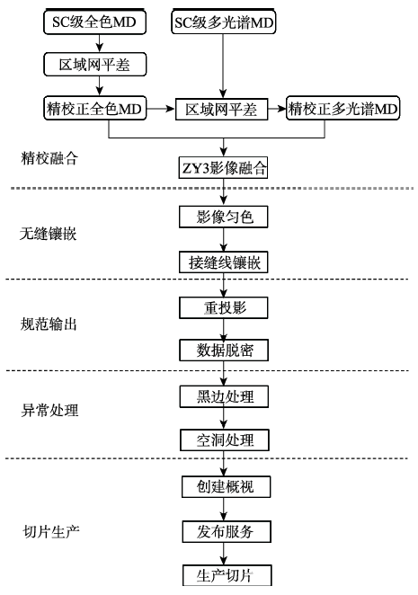
Fig. 1 Image quick processing workflow for ZY3 imagery based on ArcGIS图1 基于ArcGIS的资源三号测绘卫星影像底图快速处理流程图 |
Tab. 1 Comparison of experiment data表1 实验数据对比 |
| 数据处理项 | 传统方法耗时 | ArcGIS快速处理方法耗时 | 传统方法占用的存储空间 | ArcGIS流程占用的存储空间 |
|---|---|---|---|---|
| 金字塔统计值 | 12 min | 12 min | 1.3 GB | 1.3 GB |
| 区域网平差 | 1 h 30 min | 12 min | 35.9 GB(16-BIT) | 忽略不计 |
| 影像融合 | 2 h 45 min | 实时处理 | 31.2 GB(8-BIT) | 忽略不计 |
| 镶嵌匀色 | 2 h 50 min | 6 min | 37.8 GB | 忽略不计 |
| 数据脱密 | 1 h 12 min | 实时处理 | 37.8 GB | 忽略不计 |
| 投影变换 | 1 h 43 min | 实时处理 | 40.6 GB | 忽略不计 |
| 去除黑边 | 1 h | 实时处理 | 40.6 GB | 忽略不计 |
| 去除空洞 | 1 h | 实时处理 | 40.6 GB | 忽略不计 |
| 创建概视 | 6 min | 6 min | 8.4 GB | 8.4 GB |
| 生产切片 | 1 h 15 min | 1 h 15 min | 450 MB | 450 MB |
| 总计 | 13 h 21 min | 1 h 51 min | 274.9 GB | 10.4 GB |
The authors have declared that no competing interests exist.
| [1] |
|
| [2] |
|
| [3] |
|
| [4] |
|
| [5] |
|
| [6] |
|
| [7] |
|
| [8] |
|
| [9] |
|
| [10] |
|
| [11] |
|
| [12] |
|
| [13] |
|
| [14] |
|
| [15] |
|
| [16] |
|
| [17] |
|
| [18] |
|
| [19] |
|
| [20] |
|
| [21] |
|
| [22] |
|
| [23] |
|
| [24] |
|
/
| 〈 |
|
〉 |