
地震烈度应急遥感评估研究与应用进展
作者简介:王晓青(1963-),男,湖北应城人,研究员,主要从事地震风险评估、地震应急遥感应用等方面研究。E-mail: wangxiaoq517@163.com
收稿日期: 2015-03-02
要求修回日期: 2015-05-12
网络出版日期: 2015-12-20
基金资助
中国地震局地震预测研究所基本科研业务费专项(2013IES010106)
高分辨率对地观测系统重大专项“高分遥感地震监测与应急应用示范系统(一期)”项目(31-Y30B09-9001-13/15)
Advance on the RS-based Emergency Seismic Intensity Assessment
Received date: 2015-03-02
Request revised date: 2015-05-12
Online published: 2015-12-20
Copyright
地震烈度是地震引起的地面震动及其影响强弱程度的度量。地震烈度在地震区划、建筑物与生命线工程抗震设计、灾害防御等方面具有广泛的应用。震后评定的地震烈度图是地震应急救援、恢复重建等的主要依据之一,因此,震后快速确定地震烈度具有重要救灾与减灾意义。本文在论述地震应急及其对遥感应用需求的基础上,回顾了遥感技术及其在地震应急研究与应用中的发展历程,概述了中国地震应急遥感应用的基本思路、地震灾害和地震烈度遥感定量评估方法,展示了该方法在巴楚-伽师地震、汶川地震、玉树地震、芦山地震、鲁甸地震等震后实际应急应用效果。最后,指出了目前震害遥感定量评估中存在的问题,并展望了未来震害遥感定量评估研究与应用。
王晓青 , 窦爱霞 , 丁香 , 李旖雯 . 地震烈度应急遥感评估研究与应用进展[J]. 地球信息科学学报, 2015 , 17(12) : 1536 -1544 . DOI: 10.3724/SP.J.1047.2015.01536
The seismic intensity is used to describe the intensity of an earthquake by measuring its impacts on the earth surface, humans, natural objects, and man-made structures on a scale from I (not felt) to XII (total destruction). Seismic intensity has been widely applied in many aspects, such as seismic zoning, seismic design of building and earthquake disaster prevention. The post-earthquake estimated seismic intensity map is one of the main foundations for earthquake relief, recovery and reconstruction. Therefore, the rapid determination of seismic intensity has important significance for disaster relief and reduction. In this paper, based on the discussion of earthquake emergency and its requirements for remote sensing application, the remote sensing technology and its development process in earthquake emergency research and the relevant application are reviewed. The basic train of thought for the post-earthquake emergency application of remote sensing, especially the quantitative assessment methods of seismic damage and seismic intensity in China are summarized. The practical post-event emergency application effects are described for cases of Bachu-Jiashi earthquake, Wenchuan earthquake, Yushu earthquake, Lushan earthquake, Ludian earthquake etc. These cases show that the remote sensing based emergency seismic intensity assessment technology has realized its practical application. In the end, we summarized the existing problems in the quantitative assessment of earthquake disaster based on remote sensing, and prospected the research and application of methods and techniques in the future.
Key words: seismic emergency; seismic damage; seismic intensity; RS based assessment
Tab.1 The Chinese seismic intensity scale表1 中国地震烈度表(据文献[8]简化) |
| 地震烈度 | 人的感觉 | 房屋震害 | 其他震害现象 | |
|---|---|---|---|---|
| 震害程度 | 平均震害指数 | |||
| Ⅵ | 多数人站立不稳,少数人惊逃户外 | 个别中等破坏,少数轻微破坏,多数基本完好 | 0.00–0.11 | 家具和物品移动;河岸和松软土出现裂缝,饱和砂层出现喷砂冒水;个别独立砖烟囱轻度裂缝 |
| Ⅶ | 大多数人惊逃户外,骑自行车的人有感觉,行驶中的汽车驾乘人员有感觉 | 少数中等破坏,多数轻微破坏和/或基本完好 | 0.09–0.31 | 物体从架子上掉落;河岸出现塌方,饱和砂层常见喷水冒砂,松软土地上地裂缝较多;大多数独立砖烟囱中等破坏 |
| Ⅷ | 多数人摇晃颠簸,行走困难 | 个别毁坏,少数严重破坏,多数中等和/或轻微破坏 | 0.29–0.51 | 干硬土上出现裂缝,饱和砂层绝大多数喷砂冒水;大多数独立砖烟囱严重破坏 |
| Ⅸ | 行动的人摔倒 | 少数毁坏,多数严重和/或中等破坏 | 0.49–0.71 | 干硬土上多处出现裂缝,可见基岩裂缝、错动,滑坡、塌方常见;独立砖烟囱多数倒塌 |
| Ⅹ | 骑自行车的人会摔倒,处不稳状态的人会摔离原地,有抛起感 | 大多数毁坏 | 0.69–0.91 | 山崩和地震断裂出现;基岩上拱桥破坏;大多数独立砖烟囱从根部破坏或倒毁 |
| Ⅺ | - | 绝大多数毁坏 | 0.89–1.00 | 地震断裂延续很大,大量山崩滑坡 |
| Ⅻ | - | 几乎全部毁坏 | 1.00 | 地面剧烈变化,山河改观 |
注:表中的“个别”为10%以下;“少数”为10%~45%;“多数”为40%~70%;“大多数”为60%~90%;“绝大多数”为80%以上 |
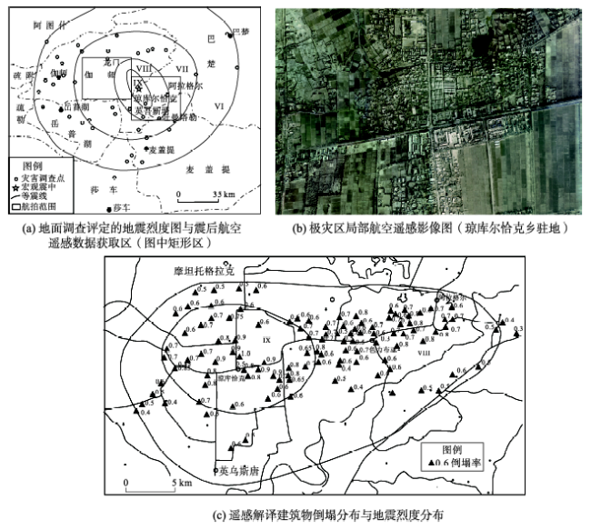
Fig. 1 The remote sensing based emergency estimate result of seismic intensity of Ms 6.8 for Bachu-Jiashi, Xinjiang earthquake, occurred on February 24, 2003图1 2003年2月24日新疆巴楚-伽师6.8级地震烈度应急遥感评估结果图 |
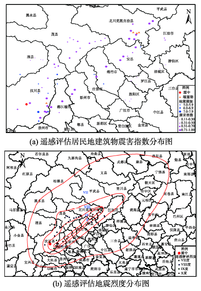
Fig. 2 The remote sensing based emergency estimate results of building damage and seismic intensity of Ms8.0 for Wenchuan, Sichuan earthquake, occurred on May 12, 2008图2 2008年5月12日汶川8.0级地震建筑物震害与地震烈度应急遥感评估图 |
Tab. 2 The cases of remote sensing based emergency application of typical earthquake events表2 部分地震应急遥感应用案例情况表 |
| 地震案例 | 典型遥感应用 |
|---|---|
| 2008年汶川地震 | 建筑物与生命线工程震害、地震地质灾害、震害指数和烈度遥感评估 |
| 2010年玉树地震 | 建筑物与生命线工程震害、地震地质灾害、烈度评估、损失评估、恢复重建 |
| 2011年盈江地震 | 建筑物震害、震害指数和烈度评估 |
| 2012年彝良地震 | 地震滑坡、建筑物震害 |
| 2012年洛浦地震 | 背景遥感影像等服务 |
| 2011年印度地震(西藏边境附近) | 背景遥感影像等服务 |
| 2010年海地地震 | 建筑物震害、震害指数和烈度遥感评估、损失评估 |
| 2010年智利地震 | 建筑物等震害、地震海啸影响 |
| 2011年日本地震 | 核电站震害及影响、建筑物震害、地震海啸影响 |
| 2013年芦山地震 | 建筑物与道路交通震害、地震地质灾害,烈度评估、损失评估 |
| 2013年岷县地震 | 建筑物与道路交通震害、地震地质灾害 |
| 2014年鲁甸地震 | 建筑物与道路交通震害、地震地质灾害、烈度评估 |
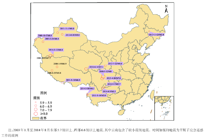
Fig. 3 A partial view of the cases of remote sensing based emergency estimate of earthquakes图3 地震应急遥感评估部分震例分布图 |
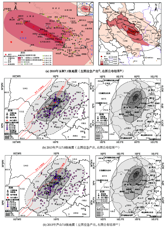
Fig. 4 The remote sensing based emergency estimated seismic intensities (left) compared with the official announced results (right) for typical earthquake events图4 典型震例地震烈度应急遥感评估结果图(左列)与公布结果(右列)对比图(⑦中国地震局地震预测研究所,2010. 2010年青海玉树7.1级地震震害遥感影像解译图集(内部)⑧ 国务院关于印发玉树地震灾后恢复重建总体规划的通知. http://www.gov.cn/zhengce/content/2010-06/13/ content_5598.htm. 2010.6.13) |
The authors have declared that no competing interests exist.
| [1] |
|
| [2] |
中国地震局地震研究所.一九七六年唐山地震震害图[M].北京:地震出版社,1985.
|
| [3] |
|
| [4] |
|
| [5] |
|
| [6] |
|
| [7] |
国家质量技术监督局. GB/T 17742-1999中国地震烈度表[S].北京:中国标准出版社,1999:1-3.
|
| [8] |
中华人民共和国国家质量监督检验检疫总局,中国国家标准化管理委员会. GB/T 17742-2008中国地震烈度表[S].北京:中国标准出版社,2008:1-4.
|
| [9] |
|
| [10] |
|
| [11] |
|
| [12] |
|
| [13] |
|
| [14] |
|
| [15] |
|
| [16] |
|
| [17] |
|
/
| 〈 |
|
〉 |