
中国古-近-现代地图的传承脉络探究
作者简介:齐清文(1963-),男,博士,研究员,主要从事地图学理论、方法与应用研究。E-mail: qiqw@igsnrr.ac.cn
收稿日期: 2015-07-13
要求修回日期: 2015-09-13
网络出版日期: 2016-01-10
基金资助
科技基础性工作专项项目“《中国近代地图志》编研”(2012FY120200)
Research on the Heritage Sequence of Chinese Ancient, Near-modern and Modern Cartography
Received date: 2015-07-13
Request revised date: 2015-09-13
Online published: 2016-01-10
Copyright
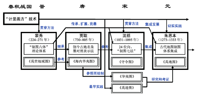
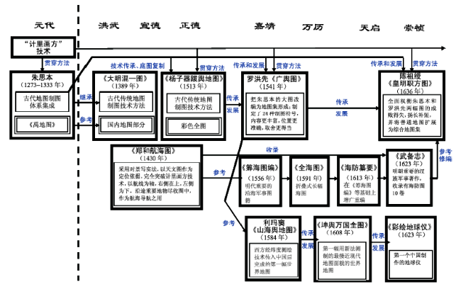
本文探究中国古-近-现代地图的传承和发展脉络,有地图制图技术传承和地图数据资料传承两重含义。中国古代地图学对近代地图学影响最大的是“计里画方”技术、西晋裴秀的“制图六体”理论、唐代贾耽的制图方法和作品、宋代沈括的二十四位向和“制图七法”、元代朱思本理论和技术体系及其地图作品5项成果。明代地图制图的传承和发展有3个分支(传承线),即传统疆域和全国地图制图、航海图和海防图、引入西方制图技术后的近代地图萌芽;清代地图学的传承和发展的5个分支(传承线),即皇家主导的全国地图制图、民间自发的全国地图制图、世界地图制图、海洋图制图、工程地图制图;民国时期的地图制图传承和发展的6个分支(传承线),即私营出版社制图、专题地图制图、航海和航道地图制图、工程地图制图、地形图制图、军事地图制图。中国古代和近代地图,对当今的地图学而言,有丰富的史料、文物价值,也有一定的信息承载价值,但在利用上有相当的难度,需要我们深入研究,探讨出适合的地图再利用模式;从地图表现形式来看,现代地图学似乎有“仿古”的趋势,但这是科学发展的一种螺旋式上升,代表了从古代地图到现代地图传承与发展的“否定之否定”的辩证式升华。
齐清文 . 中国古-近-现代地图的传承脉络探究[J]. 地球信息科学学报, 2016 , 18(1) : 2 -13 . DOI: 10.3724/SP.J.1047.2016.00002
This paper researched the heritage sequence of Chinese ancient, near-modern and modern cartography, including two heritage aspects of cartographic theory-technologies and map data. The five most important and influential items of Chinese ancient cartography that have impacts on the near-modern cartography were the method of “counting distance and drawing maps according to affine squares”, the “Six Key-Point of Mapping” by Pei Xiu in the West-Jin dynasty, Jia Dan’s mapping method and map products in Tang dynasty, Shen Kuo’s 24 directions and “Seven Method of Mapping” in Song dynasty, and Zhu Siben’s cartographic theory, technologies and map products. There were three cartographic heritage lines in Ming dynasty, i.e., the heritage line of traditional territory and national mapping, the heritage line of nautical and coastal defense mapping, and the heritage line of embryonic stage of Chinese near-modern cartography after the introduction of western mapping technologies. As for the Qing dynasty, there were five cartographic heritage lines, which were the emperor sponsored national mapping, the non-governmental national mapping, the world map compilation, the nautical map compilation, and the engineering map making. And in the publican period, there were six cartographic heritage lines, which were the map making through private publishing houses, the edition of thematic maps, the nautical and sea & river route navigation mapping, the engineering map making, the topographic map making, and the map making for military affairs. In the modern society, the Chinese ancient and near-modern cartographic achievements are meaningful and helpful to the historical research and cultural relic exploration, while having some difficulties in map re-use, thus further research is necessary on the re-use of these maps. From the aspect of map representation, there is a tendency that the ancient and near-modern cartographic method would return to the modern cartography, but this is like a spiral rise of scientific development, representing a process of the negation of negation for the Chinese cartographic heritage and development from the ancient time to modern society.
Fig. 1 The heritage diagram of Chinese ancient cartography and its impact on near-modern cartography图1 中国古代地图学传承脉络及其对近代地图学的影响 |
Fig. 2 The heritage diagram of the Chinese cartography in Ming dynasty图2 中国明代地图学的传承脉络 |
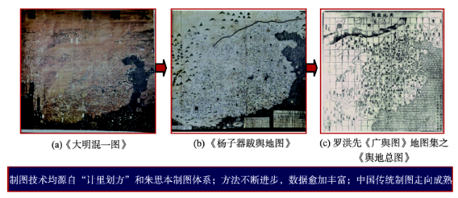
Fig. 3 The traditional territory map of Ming dynasty and the heritage relationships between three mapping representations of the national scale map in Ming dynasty图3 明代传统疆域地图和全国地图的分支的3个典型代表之间的传承 |
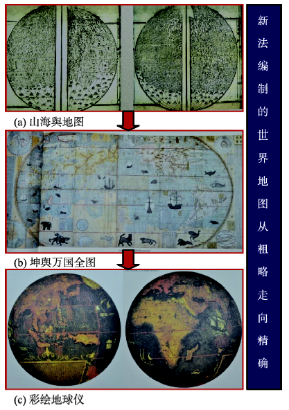
Fig. 4 The development and branching of Chinese near-modern cartography after the introduction of western mapping techniques图4 引入西方制图技术后的中国近代地图萌芽分支 |
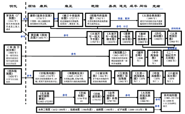
Fig. 5 The heritage diagram of the Chinese cartography in Qing dynasty图5 中国清代地图学的传承脉络 |
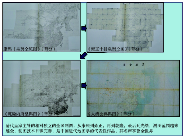
Fig. 6 The heritage diagram for the representative national mapping products sponsored by government in Qing Dynasty图6 清代皇家主导的全图制图代表性成果之间的传承 |
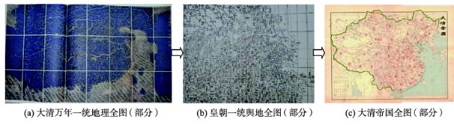
Fig. 7 The heritage diagram for the representative national mapping products non-governmentally sponsored in Qing Dynasty图7 民间自发的全国地图编制的代表成果之间的传承 |
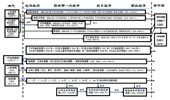
Fig. 8 Heritage diagram of Chinese cartography in the republican period图8 民国时期中国地图学的传承脉络 |
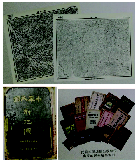
Fig. 9 Representative map products in the republican period图9 民国时期的代表地图成果 |
| [1] |
[
|
| [2] |
[
|
| [3] |
[
|
| [4] |
[
|
| [5] |
“中华舆图志编制及数字展示”项目组.中华舆图志[M].北京:中国地图出版社,2011.
[ The project team, a collection of Chinese ancient maps[M]. Beijing: Sino maps Press, 2011. ]
|
| [6] |
[
|
| [7] |
《地图的见证:中国疆域变迁与地图发展》编辑委员会.地图的见证——中国疆域变迁与地图发展[M].北京:中国地图出版社,2011.
[ Compilation Committee, Witness from Maps-Evolution of Chinese Territory and Maps[M]. Beijing: Sino-maps Press, 2013. ]
|
| [8] |
[
|
| [9] |
[
|
| [10] |
[
|
| [11] |
[
|
| [12] |
[
|
| [13] |
[
|
| [14] |
[
|
| [15] |
[
|
| [16] |
[
|
| [17] |
[
|
| [18] |
[
|
| [19] |
[
|
| [20] |
[
|
/
| 〈 |
|
〉 |