
探地雷达在地下考古遗存探测中的实验与应用
作者简介:宗 鑫(1991-),男,硕士生,研究方向为探地雷达理论及其在考古探查中的应用。E-mail:zongxin@radi.ac.cn
收稿日期: 2015-07-22
要求修回日期: 2015-09-24
网络出版日期: 2016-02-04
基金资助
国家自然科学基金项目(41271427)
国家文物局文物保护科学和技术研究重点课题(20130201)
Experiments and Applications of Ground Penetrating Radar in the Investigation of Subsurface Archaeological Interest
Received date: 2015-07-22
Request revised date: 2015-09-24
Online published: 2016-02-04
Copyright
近年来,探地雷达被越来越多地应用于考古探查中。由于反演多解性问题的存在,雷达图像上的异常既可能是考古目标引起的,也可能是由于地下环境介质的不连续性引起的,所以探究不同类型的考古遗存在探地雷达图像上的典型异常响应,有助于准确识别雷达图像上的“真”异常,剔除一些“假”异常。首先,本文基于西北干旱-半干旱区文物埋藏环境,在河北省怀来县遥感综合试验站试验区设计实施了地下目标体探地雷达探测实验,分析了不同材质的小尺度目标体及夯土结构在探地雷达图像上的响应特征;然后,进一步将探地雷达应用于悬泉置遗址地下城墙基址的探测,对城墙在雷达图像上的响应特征进行了分析。实践表明,探地雷达技术在埋藏浅、小尺度、物性差异不大的考古探查中具有很好的效果,得到并解释了点状、线状、面状等不同考古目标体在探地雷达图像上的响应规律。
宗鑫 , 王心源 , 刘传胜 , 骆磊 . 探地雷达在地下考古遗存探测中的实验与应用[J]. 地球信息科学学报, 2016 , 18(2) : 272 -281 . DOI: 10.3724/SP.J.1047.2016.00272
Ground Penetrating Radar(GPR) has been more and more widely used in archaeological investigations, because it can be a non-destructive, cost-effective way to locate buried structures in archaeological studies. Compared with the conventional geophysical tools used in the shallow explorations, the electromagnetic method, ground-penetrating radar (GPR), is more economical and is capable to produce large amounts of continuous, high resolution subsurface data. GPR canextend the exploration range of remote sensing (RS) to subsurface. However, because of the non-uniqueness of inversion, an anomaly could be raised by the archaeological interest or the inhomogeneity of underground matrixes, therefore studying the typical anomalies of diferent archaeological targets on GPR images is helpful to distinguish the “true” anamolies from the “fake” anamolies. Furthemore, some experiences and references could be provided. The following experiments have been carried out: firstly, in order to analysize how the small targets of different materials and rammed earth will raise anomalies on the GPR maps, GPR was emploied to detect five pre-buried targets that are equivalent to the archaeological interest and a beacon tower in a integrated experiment station of remote sensing. The first experiment of GPR prospection was designed to simulate the buried-enviorment of the archaeological structure in the northwest region of China whose climate is predominantly arid. Secondly, the authors applied GPR in detecting the residual city walls of Xuanquanzhi ruins, then analysized the response features of the walls, and found that the detecting results well fitted the excavation. The engineering practice indicates that the ground penetrating radar technology is successful and effective in invetigating the archaeological remains which are of small scale, buried shallowly and very analogical with the matrixes in electromagnetic nature. The response models of different archaeological targets, which are respectively considered as the point, line and surface shape, have been proposed and explained according to the principle of rectilinear propagation of electromagnetic wave.
Tab. 1 The sizes and buried depths of the targets表1 目标体的尺寸和埋深 |
| 红砖构筑物 | 木棒 | 铁盒 | 瓷瓶 | 瓷碗 | |
|---|---|---|---|---|---|
| 尺寸/cm | 长:49.2 | 长:32.1 | 长:8.9 | 瓶口直径:3.2 | 高:4.1 |
| 宽:21.4 | 宽:7.2 | 宽:5.0 | 瓶身最大直径:9.2 | 碗口直径:9.8 | |
| 高:16.4 | 高:4.1 | 高:15.8 | |||
| 埋深/m | 1.8 | 1.8 | 1.0 | 1.0 | 1.0 |
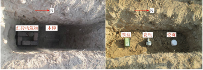
Fig. 1 Distribution of the targets in the tunnel图1 目标物在坑道中的分布 |
Tab. 2 Suitable central frequency of GPR for various depths of interest表2 探测深度与天线中心频率对应简表 |
| 深度/m | 中心频率/MHz |
|---|---|
| 0.5 | 1000 |
| 1.0 | 500 |
| 2.0 | 200 |
| 7.0 | 100 |
| 10.0 | 50 |
| 30.0 | 25 |
| 50.0 | 10 |
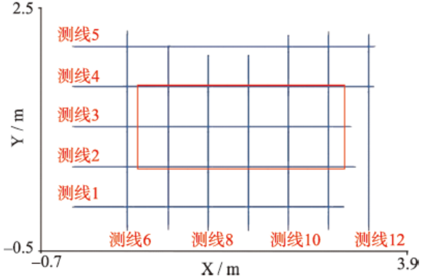
Fig. 2 Location map of the GPR profiles for the tunnel图2 坑道测线分布示意图 |
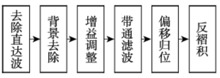
Fig. 3 Flow diagram of GPR data processing图3 数据处理流程图 |
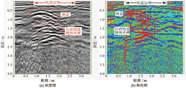
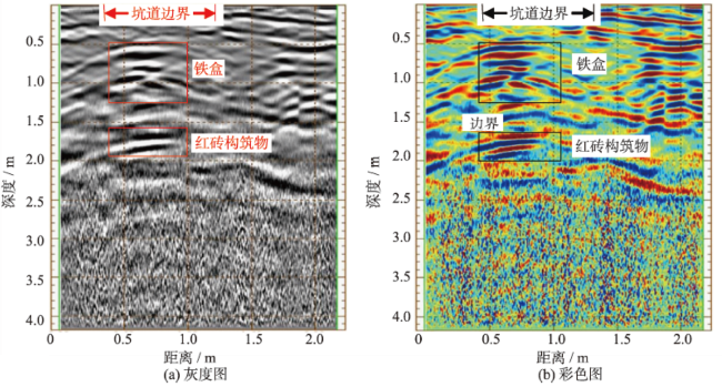
Fig. 4 The profile of line 3 for the tunnel图4 坑道测线3探地雷达图像 |
Fig. 5 The profile of line 8 for the tunnel图5 坑道测线8探地雷达图像 |
Fig. 6 The profile of line 10 for the tunnel图6 坑道测线10探地雷达图像 |
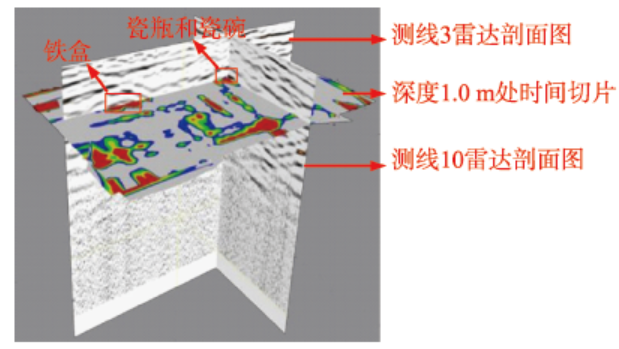
Fig. 7 The profiles of line 3 and line 10 and the time slice of 1.0m for the tunnel图7 坑道测线3、测线10雷达剖面图像和深度1.0 m处时间切片组合显示 |
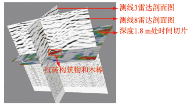
Fig. 8 The profiles of line 3 and line 8 and the time slice of 2.0 m for the tunnel图8 坑道测线3、测线8雷达剖面图像与深度1.8 m处时间切片组合显示 |
Fig. 9 The profile ofbeacon tower图9 烽火台探地雷达剖面图像 |
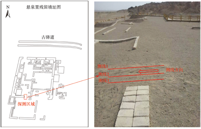
Fig. 10 The survey area and location map of the GPR profiles for Xuanquanzhi ruins图10 悬泉置探测区域以及测线布设图 |
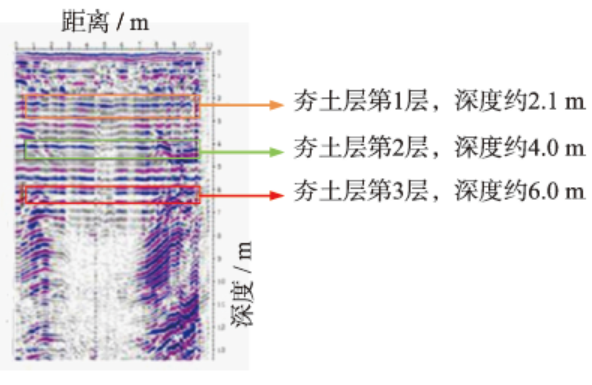
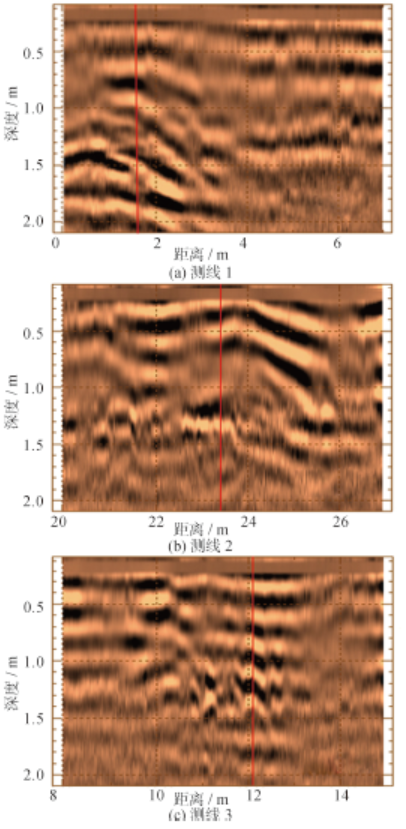
Fig. 11 The profiles for Xuanquanzhi ruins图11 悬泉置探地雷达剖面图 |
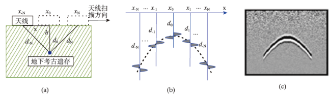
Fig. 12 The schematic diagram of detecting the archaeological interest using GPR图12 探地雷达探测地下考古遗存示意图 |
The authors have declared that no competing interests exist.
| [1] |
|
| [2] |
|
| [3] |
|
| [4] |
|
| [5] |
|
| [6] |
|
| [7] |
|
| [8] |
|
| [9] |
|
| [10] |
|
| [11] |
[
|
| [12] |
[
|
| [13] |
[
|
| [14] |
[
|
| [15] |
[
|
| [16] |
[
|
| [17] |
[
|
| [18] |
[
|
| [19] |
|
| [20] |
[
|
| [21] |
[
|
| [22] |
[
|
/
| 〈 |
|
〉 |
