
基于Coons曲面与约束三角网的区域地质调查三维建模方法
作者简介:周文辉(1992-),男,江苏如皋人,硕士生,研究方向为三维地质建模。E-mail: zhouwenhuimail@163.com
收稿日期: 2015-10-12
要求修回日期: 2015-11-18
网络出版日期: 2016-06-10
基金资助
中央高校基本科研业务费项目(N140104002)
辽宁省科学技术基金项目(2015020581)
中国地质调查局发展研究中心智能地质调查支撑平台建设与应用项目(12120115073201)
国家自然科学基金项目(41001228)
3D Regional Geological Modeling Based on Coons Surfaces and CD-TIN
Received date: 2015-10-12
Request revised date: 2015-11-18
Online published: 2016-06-10
Copyright
目前基于野外地质调查数据自动、快速地建立区域三维地质体模型是中国全面开展三维数字地质填图的迫切需求。本文基于产状、地质界线与路线剖面等野外区域地质调查要素,提出了一种二维平面地质图及路线剖面图向三维地质体模型的快速转换方法。该方法针对无剖面约束及含剖面约束2种情形,通过地质界线区域分割、多段线仿射变换等空间几何变换处理,推估出剖面线约束的地下地质界线,基于Coons曲面构建出地质体的侧面模型;然后,通过约束三角网算法构建地质体的顶、底面模型,最终建立拓扑一致的区域地质体三维模型。基于此方法,对中国1:2.5万区域地质调查试点区域进行了区域三维地质建模实践,实现了火山口、地层、岩体、断层等典型地质构造的快速三维重建。
周文辉 , 郭甲腾 , 栗云峰 , 吴立新 , 李超岭 . 基于Coons曲面与约束三角网的区域地质调查三维建模方法[J]. 地球信息科学学报, 2016 , 18(6) : 734 -741 . DOI: 10.3724/SP.J.1047.2016.00734
Automatic and efficient regional three-dimensional (3D) geological modeling based on the field geological survey data is the key issue of the nationwide 3D geological mapping nowadays. Based on the fundamental geological survey elements such as the attitudes, boundaries and sections, a method for transforming the two-dimensional (2D) geological maps and route section maps into the 3D geological models was proposed in this paper. The geological bodies that are both constrained and non-constrained by route sections were taken into consideration in this method. For the geological bodies that are constrained by sections, through the spatial geometrical processing, such as boundary regional division and polyline affine transformation, the underground boundary could be estimated using the surficial boundary constrained by the section lines. Then, based on the Coons surface, the side surfaces of the geological body were constructed by filling the areas between the top and bottom boundaries and the section lines. Afterwards, the top and bottom surfaces of the geological body were constructed by the constrained Delaunay triangulation network and the topologically consistent regional geological model was finally constructed. Based on this workflow, a 3D geological modeling practice was carried out in the domestic 1:25 000 regional geological survey experiment area. In the experiment, some typical and complex geological structures, including the volcanic edifice, stratum, rock and faults were efficiently reconstructed.
Fig. 1 3D regional geological modeling elements图1 区域三维地质建模要素 |
Fig. 2 Constraint relationship between the route sections and boundaries图2 路线剖面与地质界线的相互约束关系 |
Fig. 3 3D geological modeling workflow based on the regional geological survey elements图3 基于区调要素的三维地质建模流程 |
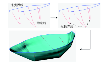
Fig. 4 Coons boundary surface图4 Coons边界曲面 |
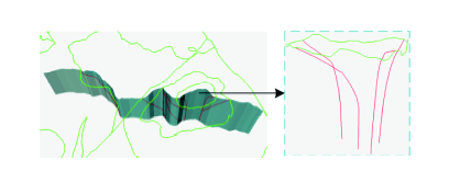
Fig. 5 Fault modeling图5 断层构建 |
Fig. 6 Geological modeling based on the Coons surface图6 基于Coons边界曲面的地质体建模 |
Fig. 7 Pinch-out model construction (there are 6 section lines in the graph, which were divided into 3 groups and the lines in the same group were connected at the bottom)图7 尖灭模型生成(共6条剖面线,分3组,每组线底端相连) |
Fig. 8 Prototype system development图8 原型系统开发 |
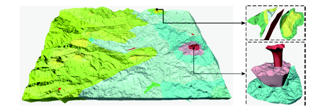
Fig. 9 The 1:25 000 3D geological mapping of a domestic area with volcanic edifice图9 国内某区含火山机构1:2.5万三维地质填图 |
The authors have declared that no competing interests exist.
| [1] |
|
| [2] |
|
| [3] |
|
| [4] |
[
|
| [5] |
[
|
| [6] |
|
| [7] |
[
|
| [8] |
[
|
| [9] |
[
|
| [10] |
[
|
| [11] |
[
|
| [12] |
[
|
| [13] |
|
| [14] |
[
|
| [15] |
[
|
| [16] |
[
|
| [17] |
|
| [18] |
[
|
| [19] |
[
|
| [20] |
[
|
/
| 〈 |
|
〉 |


