
鄱阳湖南矶湿地景观信息高分辨率遥感提取
作者简介:方朝阳(1971-),男,江西南丰人,博士,教授,主要从事空间信息科学、环境遥感和虚拟现实研究。E-mail: fcy@jxnu.edu.cn
收稿日期: 2015-09-16
要求修回日期: 2015-11-06
网络出版日期: 2016-06-10
基金资助
江西省重大生态安全问题监控协同创新中心(JXS-EW-00)
鄱阳湖湿地与流域研究教育部重点实验室主任基金(ZK2013004)
江西省对外科技合作计划(20123BDH80012)
国家测绘地理信息公益性行业科研专项(201512026)
国家科技支撑计划课题(2015BAH50F03)
The Wetland Information Extraction Research of Nanji Wetland in Poyang Lake Based on High Resolution Remote Sensing Image
Received date: 2015-09-16
Request revised date: 2015-11-06
Online published: 2016-06-10
Copyright
鄱阳湖南矶湿地是亚热带典型过水性湿地,由于该区域水文情况复杂,且泥滩、沼泽和疫水(血吸虫)分布较广,导致野外考察验证工作困难,使用传统的遥感信息提取方法很难保证该地区湿地景观的提取精度。本文以高分一号影像为数据源,综合运用数字高程模型(DEM)、归一化植被指数(NDVI)、归一化水体指数(NDWI)等辅助数据,采用面向对象分类方法,对鄱阳湖南矶湿地景观信息进行提取研究,并取得了较好的分类效果。研究结果表明:(1)基于国产高分辨率影像的面向对象分类,既兼顾了国产高分辨率影像光谱、空间、结构、纹理信息,又综合利用多源辅助数据参与到分类计算中,分类精度得到明显的提升;(2)基于面向对象与多源数据分类方法对湿地混合像元有较好地识别能力,可获得较高的总体分类精度(94.3275%)和Kappa系数(0.9324),说明利用多源数据的面向对象方法提取湿地信息是可行的,其分类结果具有较高的准确性和可信度,较好地解决了过水性湿地景观分类问题;(3)该分类方法弥补了单一遥感影像分类方法的不足,对研究国产高分卫星在提取过水性湿地景观信息方面具有重要的参考和实际意义。最后,分析了多源数据面向对象分类尚待解决的问题和下一步的研究方向。
方朝阳 , 邬浩 , 陶长华 , 高丹 , 周华 . 鄱阳湖南矶湿地景观信息高分辨率遥感提取[J]. 地球信息科学学报, 2016 , 18(6) : 847 -856 . DOI: 10.3724/SP.J.1047.2016.00847
The Nanji wetland of Poyang Lake is a typical wetland of the water-carrying type. It is quite difficult to accurately extract the information of wetland landscape from remote sensing images with the traditional information extraction approaches due to the complicated hydrology conditions and arduous field verification, and moreover, the mud flat, swamp and infested water (schistosomiasis) is widely distributed in the region. This study chose GF image as the data source, with the auxiliary data of digital elevation model (DEM), normalized difference vegetation index (NDVI) and normalized difference water index (NDWI) to ensure the accuracy of information extraction. And it uses the object-oriented classification method to extract the landscape information of the Nanji wetland, which achieved some reasonable classification results indicating in the following part; (1) Based on the object-oriented classification of domestic GF satellite remote sensing images, which contains the spectral, spatial structure and texture features, this study makes a comprehensive utilization of the multi-source data in the classification calculation, and the precision of its classification result is significantly higher than the object-oriented classification of single-source; (2) The object-oriented method of multi-source remote sensing data has better distinguish ability for mixed pixels. It obtains a higher overall accuracy of 94.3275% and a Kappa coefficient of 0.9324, which indicates a distinctive high degree of accuracy and reliability. It has effectively solved the classification problem in extracting the wetland landscape of water-carrying; (3) This method makes up the deficiency in the object-oriented classification method of single-source remote sensing image, and it acts as an important reference and has the practical significance for effectively extracting the information of water-carrying wetland landscape through the domestic GF remote sensing image. Finally, we put forward some issues to be resolved and illustrated the future research direction of the object-oriented classification of multi-source data.
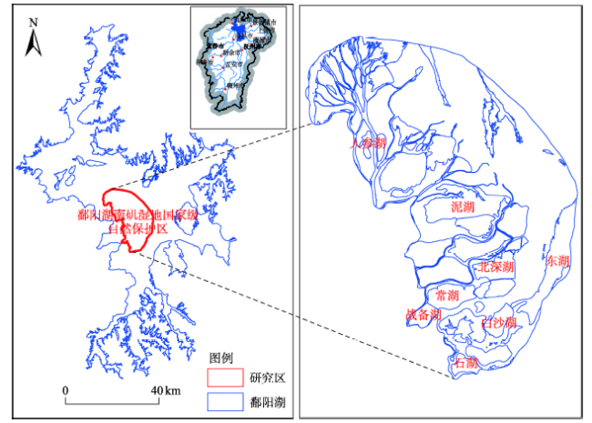
Fig.1 Location of the study area图1 研究区地理位置图 |
Tab.1 Band information of GF-1 PMS image表1 高分一号PMS相机波段信息 |
| 波段 | 空间分辨率/m | 波谱范围/μm |
|---|---|---|
| 全色波段 | 2 | 0.45~0.90 |
| 蓝色波段 | 8 | 0.45~0.52 |
| 绿色波段 | 0.52~0.59 | |
| 红色波段 | 0.63~0.69 | |
| 近红外波段 | 0.77~0.89 |
Tab.2 Classification system and interpretable symbols for each type of the wetland landscape表2 鄱阳湖南矶湿地景观分类系统及其各类型景观解译标志 |
| 一级类型 | 二级类型 | 颜色特征 | 形状、纹理 | 遥感影像 | 类型含义 | |
|---|---|---|---|---|---|---|
| 湿地 | 天然湿地 | 河流 | 浅蓝色、深蓝色 | 线状;均匀 | 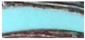 | 水流速度较快的水体,深度较大 |
| 湖泊 | 浅蓝色、深蓝色 | 大面积面状;总体均匀,局部无规则 |  | 主要是包括保护区蝶形湖泊群和部分主湖体,水深较浅,一般为理想的涉禽和游禽栖息地 | ||
| 泥滩 | 深灰色、浅灰色 | 环状或面状;均匀 | 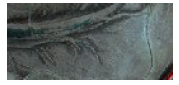 | 水生床出露,紧接水体 | ||
| 草洲 | 浅红色、深红色、褐色略带黄色 | 环状或面状;总体均匀 | 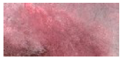 | 主要包括南荻群丛、芦苇群丛和苔草群从等 | ||
| 茭白 | 白色、浅黄色 | 面状;总体均匀 |  | 主要分布于地形较为低洼地区 | ||
| 人工湿地 | 鱼塘 | 深蓝色 | 规则矩形;均匀 | 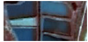 | 形状较为规则的水产养殖地 | |
| 非湿地 | 耕地 | 深红色、浅红色 | 面状;总体均匀 | 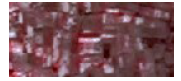 | 包括旱地和水田,主要分布在南山岛和矶山岛 | |
| 建筑用地 | 灰白色 | 无规则面状;不均匀 | 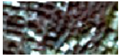 | 包括道路、居民、水坝和建筑设施,集中分布在南山岛和矶山岛 | ||
| 林地 | 深红色 | 面状;较为均匀 |  | 包括树木和高大的灌丛,主要分布于矶山岛 | ||
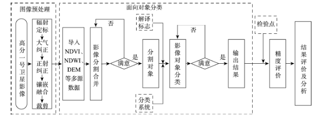
Fig.2 The technique flow chart图2 技术路线流程图 |
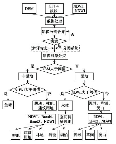
Fig.3 Schematic diagram of wetland classification rules图3 鄱阳湖南矶湿地类型分类规则示意图 |
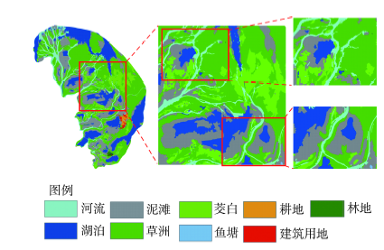
Fig.4 Wetland type extraction results of the study area图4 研究区内湿地类型提取结果图 |
Fig.5 Non-wetland type extraction results of the study area图5 研究区内非湿地类型提取结果图 |
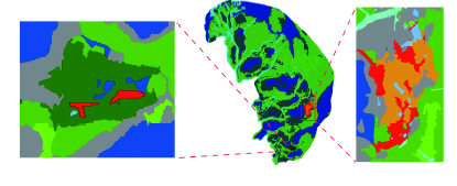
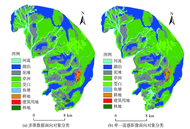
Fig.6 Wetland Classification extraction in the Nanji wetland by using two methods图6 2种分类方法的南矶湿地分类提取结果 |
Tab.3 Accuracy assessment results of the classification method based on the object-oriented classification of multi-source data表3 基于多源数据面向对象分类精度评价 |
| 实际地类 | 参考地类 | 总计 | 用户精度/(%) | |||||||||
|---|---|---|---|---|---|---|---|---|---|---|---|---|
| 河流 | 湖泊 | 泥滩 | 草洲 | 茭白 | 鱼塘 | 耕地 | 建筑用地 | 林地 | ||||
| 河流 | 229 | 4 | 0 | 0 | 2 | 0 | 0 | 0 | 0 | 235 | 97.45 | |
| 湖泊 | 2 | 249 | 6 | 0 | 0 | 0 | 0 | 0 | 0 | 257 | 96.89 | |
| 泥滩 | 1 | 0 | 313 | 0 | 2 | 0 | 7 | 0 | 0 | 323 | 96.90 | |
| 草洲 | 2 | 0 | 13 | 326 | 8 | 0 | 5 | 7 | 3 | 364 | 89.56 | |
| 茭白 | 1 | 0 | 0 | 1 | 323 | 0 | 0 | 2 | 0 | 327 | 98.78 | |
| 鱼塘 | 0 | 0 | 0 | 0 | 0 | 39 | 0 | 0 | 0 | 39 | 100.00 | |
| 耕地 | 1 | 0 | 0 | 0 | 0 | 3 | 48 | 5 | 0 | 57 | 84.21 | |
| 建筑用地 | 4 | 0 | 0 | 0 | 0 | 0 | 3 | 51 | 3 | 61 | 83.61 | |
| 林地 | 0 | 0 | 0 | 0 | 0 | 0 | 0 | 12 | 35 | 47 | 74.47 | |
| 总计 | 240 | 253 | 332 | 327 | 335 | 42 | 63 | 77 | 41 | 1710 | ||
| 生产精度/(%) | 95.42 | 98.42 | 94.28 | 99.69 | 96.42 | 92.86 | 76.19 | 66.23 | 85.37 | |||
| 总体精度/(%) | 94.3275 | |||||||||||
| kappa系数 | 0.9324 | |||||||||||
Tab.4 Accuracy assessment results of the classification method based on the object-oriented classification of single-source data表4 基于单源遥感数据面向对象分类精度评价 |
| 实际地类 | 参考地类 | 总计 | 用户精度/(%) | |||||||||
|---|---|---|---|---|---|---|---|---|---|---|---|---|
| 河流 | 湖泊 | 泥滩 | 草洲 | 茭白 | 鱼塘 | 耕地 | 建筑用地 | 林地 | ||||
| 河流 | 223 | 4 | 41 | 1 | 2 | 0 | 0 | 0 | 0 | 271 | 82.29 | |
| 湖泊 | 6 | 248 | 5 | 0 | 1 | 0 | 0 | 0 | 0 | 260 | 95.38 | |
| 泥滩 | 3 | 1 | 265 | 0 | 2 | 3 | 1 | 3 | 0 | 278 | 95.32 | |
| 草洲 | 2 | 0 | 20 | 322 | 8 | 0 | 22 | 9 | 4 | 387 | 83.20 | |
| 茭白 | 1 | 0 | 0 | 2 | 320 | 0 | 0 | 1 | 0 | 324 | 98.77 | |
| 鱼塘 | 0 | 0 | 1 | 0 | 1 | 39 | 0 | 0 | 0 | 41 | 95.12 | |
| 耕地 | 1 | 0 | 0 | 2 | 0 | 0 | 37 | 7 | 0 | 47 | 78.72 | |
| 建筑用地 | 4 | 0 | 0 | 0 | 0 | 0 | 3 | 25 | 0 | 32 | 78.13 | |
| 林地 | 0 | 0 | 0 | 0 | 1 | 0 | 0 | 32 | 37 | 70 | 52.86 | |
| 总计 | 240 | 253 | 332 | 327 | 335 | 42 | 63 | 77 | 41 | 1710 | ||
| 生产精度/(%) | 92.92 | 98.02 | 79.82 | 98.47 | 95.52 | 92.86 | 58.73 | 32.47 | 90.24 | |||
| 总体精度/(%) | 88.6550 | |||||||||||
| kappa系数 | 0.8649 | |||||||||||
The authors have declared that no competing interests exist.
| [1] |
[
|
| [2] |
[
|
| [3] |
|
| [4] |
|
| [5] |
[
|
| [6] |
[
|
| [7] |
[
|
| [8] |
[
|
| [9] |
[
|
| [10] |
|
| [11] |
[
|
| [12] |
|
| [13] |
|
| [14] |
|
| [15] |
[
|
| [16] |
[
|
| [17] |
[
|
| [18] |
[
|
| [19] |
[
|
| [20] |
[
|
| [21] |
[
|
| [22] |
[
|
| [23] |
[
|
/
| 〈 |
|
〉 |