遥感科学与应用技术

基于标记控制分水岭分割方法的高分辨率遥感影像单木树冠提取

  • 郭昱杉 1, 2 ,
  • 刘庆生 , 1, * ,
  • 刘高焕 1 ,
  • 黄翀 1
展开
  • 1. 中国科学院地理科学与资源研究所 资源与环境信息系统国家重点实验室,北京 100101
  • 2. 中国科学院大学,北京 100049
*通讯作者:刘庆生(1971-),男,副研究员,研究方向为遥感与地理信息系统在资源环境评价中的应用研究。E-mail:

作者简介:郭昱杉(1992-),女,硕士生,研究方向为遥感与地理信息系统的应用。E-mail:

收稿日期: 2015-09-11

  要求修回日期: 2015-12-17

  网络出版日期: 2016-09-27

基金资助

国家科技支撑计划项目(2013BAD05B03)中国科学院战略性先导专项项目(XDA05050601)国家自然科学基金项目(41023010、41271407)

Individual Tree Crown Extraction of High Resolution Image Based on Marker-controlled Watershed Segmentation Method

  • GUO Yushan 1, 2 ,
  • LIU Qingsheng , 1, * ,
  • LIU Gaohuan 1 ,
  • HUANG Chong 1
Expand
  • 1. State Key Laboratory of Resources and Environmental Information System, Institute of Geographic Sciences and Natural Resources Research, CAS, Beijing 100101, China
  • 2. University of Chinese Academy of Sciences, Beijing 100049, China
*Corresponding author: LIU Qingsheng, E-mail:

Received date: 2015-09-11

  Request revised date: 2015-12-17

  Online published: 2016-09-27

Copyright

《地球信息科学学报》编辑部 所有

摘要

树冠是树木的重要组成,可以直接反映树木健康状况。高空间分辨率遥感影像和遥感技术为快速获取详细的树冠信息和实时监测林冠变化提供了有效的途径。因此,基于高空间分辨率遥感影像的单木树冠提取方法研究对现代森林管理具有重要意义。本文以黄河三角洲地区孤岛林场人工刺槐林和旱柳为研究对象,以QuickBird影像为数据源,首先利用面向对象方法实现研究区林地和非林地分类;然后以林地为掩膜,提取出树冠分布范围;在此基础上,分别选取疏林区和密林区为试验区域,通过形态学开闭重建滤波,平滑图像,去除噪声;最后,利用标记控制分水岭分割方法分别对疏林区和密林区进行树冠提取。本文以人工勾绘结果为参考进行精度验证,结果显示疏林区F测度达到87.8%,密林区F测度达到65.5%,表明该提取方法简单易行,精度可靠。

本文引用格式

郭昱杉 , 刘庆生 , 刘高焕 , 黄翀 . 基于标记控制分水岭分割方法的高分辨率遥感影像单木树冠提取[J]. 地球信息科学学报, 2016 , 18(9) : 1259 -1266 . DOI: 10.3724/SP.J.1047.2016.01259

Abstract

Since the 1990s, a large number of trees in the Gudao forest area have been threatened by both the natural and human effects, which caused huge losses to the forestry development of the Yellow River Delta. Therefore, the more detailed and timely information of forests is required for improving the local forest management and ecosystem monitoring. Individual tree crown delineation has been demonstrated to be an efficient way to carry out forestry inventories at a fine scale, as the tree crown serves as the basic unit for biomass measurement, species recognition, or health monitoring, etc. The increasing availability and affordability of high spatial resolution remote sensing images provides great potential for accurately characterizing the tree crown. Current tree crown extraction methods based on the imagery were easily interfered by the background objects, especially when there were mixtures of trees, shrubs and grass. A conventional watershed segmentation approach could cause over-segmentation of the imagery because the branches in the imagery are similar to some small tree crowns in shape and scale. To overcome such issues, a new tree crown extraction method based on the object-oriented extraction and the marker-controlled watershed segmentation with the morphological filtering was presented in this paper to extract the individual tree crown from high spatial resolution image. Firstly, the tree crown area was separated from the background using the object-oriented method. After that, the morphological opening and closing operators were employed to smooth the image and remove the noises from the image. Then, we located the tree tops by detecting the local maximum. These tree tops were recognized as markers for the subsequent segmentation. Finally, the tree crowns were delineated through the marker-controlled watershed method. Based on the QuickBird image, we applied this method to the deciduous tree crown delineation of Gudao forest area in the Yellow River Delta. Both the sparse forest area and the dense forest area are tested in order to verify the universality and applicability. To evaluate the method proposed in this paper, we conducted a visual interpretation based on the original images of two plots, and the resulted manually delineated crown maps were then regarded as the reference maps. The delineation accuracies were assessed by comparing the spatial relationships of the automated delineated crowns and the reference crowns. The results showed that the overall extraction accuracy is 87.8% for the sparse forest area, and 65.5% for the dense forest area, which indicated that the tree crown extraction method proposed in this study is effective and promising.

1 引言

树冠是树木的重要组成部分,也是反映树木信息最直接的部分。通过提取遥感影像中的树冠信息,可以检测由林火、病虫害、风倒、干旱等引起的林冠变化,对森林健康监测和管理具有重要意义。目前,针对单木树冠提取的方法可以分为3类:
(1)先探测树冠顶点,再由树冠顶点描绘树冠轮廓,如先利用局部最大值法、3D模型方法等确定树冠顶点,再采取分水岭分割、爬坡法等探测树冠边界。Pouliot[1]首先进行局部最大值滤波,再从局部最大值点出发,发出若干条射线,探测光谱反射值最大变化率的发生点,即为树冠边界点。Chen等[2]运用高空间分辨率Lidar影像建立树冠高度模型,利用可变大小窗口搜索局部最大值,作为树冠顶点,然后利用标记控制分水岭分割方法提取树冠。Wang等[3]从光谱和几何2方面出发探测树冠顶点。假设树冠顶点既是光谱局部最大值,同时位置接近树冠几何中心。根据局部非最大值抑制探测的光谱最大值和基于形态学距离变换图像探测的局部最大值,取交集作为树冠顶点,然后运用标记控制分水岭算法分割树冠。Ke等[4]结合数学形态学,从光谱、形状以及专家知识3方面限制,获得树冠顶点。首先通过滑动窗口获得光谱局部最大值,然后以主动轮廓模型提取的树冠为模型,利用模板匹配法探测与模板重心相关性最高的位置,得到基于形状的局部最大值,修正光谱局部最大值。由于已知研究区人工林种植间隔为2 m×2 m,因此最终获得的树冠顶点间隔不得小于2 m,以此知识去除假树冠顶点。最后,利用爬坡法得到单木树冠。
(2)直接探测树冠边界,如谷地跟踪法、模板匹配法等。Gougeon[5]提出了基于光谱的谷地跟踪算法,该算法认为每棵树冠周围环绕较暗阴影的明亮区域,通过移动窗口搜索光谱最小值来提取树冠边界,不过该方法不适用于较密的林地。Pollock[6]引入了基于形状的模版匹配法,以模板代表树冠形状,与模板相关性最高的位置即为单木树冠所在位置。
(3)利用多尺度的方法,不同大小的树冠在不同的尺度下进行分割。如Brandtberg和Walter[7]采用多尺度方法,在每一个尺度下计算灰度曲率,树冠边界被认为是灰度曲率的过零点。Jing等[8]分别在每一个尺度下进行高斯滤波和分水岭分割,然后对每个尺度的结果进行修正和整合,该方法在提取阔叶林树冠时精度为65%。
相比之下,中国的研究起步较晚,技术尚不成熟,还有很大的提升空间。目前,大部分的单木树冠提取研究主要针对针叶林,而针对阔叶林单木树冠提取的研究还不多见[9]。这是因为针叶树冠形状规则,大多呈圆锥形,有利于提取,而阔叶树树冠较大,树冠内部亮度变化不均匀,不易探测树冠边缘,因此阔叶林树冠提取是研究的难点和热点。目前大多数的树冠提取方法直接作用于整个图像,分割树冠时易受周围背景和灌木的影响。为解决这个问题,本文在分割前先利用面向对象分类方法提取出林冠部分,使接下来的分割过程只需描绘出每个对象内的单木树冠,减少了周围背景的干扰。由于高空间分辨率遥感影像中阔叶树内部亮度变化不均匀,识别树冠顶点时可能在一个树冠内探测到多个局部最大值,通常的做法是先进行滤波。本文引入形态学滤波器对图像进行了平滑,使局部最大值探测获得了较好的效果。为解决分水岭算法易造成过分割的现象,本文将树冠顶点作为标记,应用标记控制分水岭算法开展分割。
自20世纪90年代以来,黄河三角洲孤岛林场受到自然和人为因素的影响,树木健康状况下降,许多地方出现大面积枯稍、甚至死亡,给黄河三角洲林业发展带来了巨大损失[10]。研究者从不同角度对黄河三角洲孤岛林场进行了一些研究:姚玲等[11]基于Landsat TM/ETM+数据结合各种植被指数对该地区人工刺槐林健康状况进行了分类和评价;刘庆生[12]等通过图像运算和ISODATA非监督分类对人工刺槐林林冠健康进行了有效检测;王红等[13]基于IKONOS和Landsat 8 OLI影像,结合光谱信息和空间纹理信息,对黄河三角洲人工刺槐林健康状况采用最大似然法分类;张珍珍等[14]首先结合植被指数利用决策树分类提取林区,然后基于IKONOS影像灰度共生矩阵对刺槐林健康状况采用最大似然法进行分类。黄河三角洲孤岛林场单木树冠提取对该地区林业和经济发展具有重要意义。上述研究初步得到了黄河三角洲人工刺槐林的健康状况,但仅针对成片林的评价结果对于黄河三角洲人工刺槐林管理、保护和更新来说还远远不够,需要针对单木树冠进行更详细的研究。

2 研究区概况及数据来源

黄河三角洲位于117°31′~119°18′E和36°55′~38°16′N之间,主要分布于山东省东营市和滨州市境内,受太平洋和欧亚大陆的共同作用,该地区四季分明、雨热同期,属于温带大陆性季风气候[15]。植被类型主要为暖温带落叶阔叶林,区内植被类型少、结构简单。植被的分布主要受地貌类型、土壤含盐量、水分、潜水矿化度等因素的制约和人类活动的影响,黄河三角洲地区共有40余科、160余种植物,其中以禾本科、菊科草本植物为主体。该区自然植被为草地植被,另外也分布着金合欢(Acacia farnesiana L. Willd)、柳树(S. matsudana)等落叶阔叶树。20世纪50年代开始进行刺槐(Robinia pseudoacacia L.)、白蜡(Fraxinus chinensis)等人工林的栽培和种植[16]。孤岛林场位于黄河三角洲地区,至1995年,林场总面积达到60 500 hm2,有人工刺槐林5466.7 hm2,天然林7800 hm2,其中,天然柳林1333.3 hm2,到1999年建成了华东平原地区最大的人工刺槐林地之一。但自20世纪90年代以来,受各种自然和人为因素的影响,许多地方的林地出现了枯梢或死亡的现象。
本文以QuickBird影像为数据源,获取一景覆盖试验区的QuickBird全色增强标准影像,拍摄时间为2003年10月11日02时26分12秒。空间分辨率为0.6 m,包括红(620~688 nm)、绿(499~594 nm)、蓝(447~512 nm)和近红外(755~874 nm)4个波段,采用3、2、1波段彩色合成影像。
为了验证该方法的普遍性和实用性,本文在影像中选取疏林区(郁闭度<0.2)和密林区(郁闭度>0.7)2块样地进行实验,实验图像大小分别为200像元×200像元、100像元×100像元,区域无云覆盖,质量较好。

3 研究方法

本文首先借助ENVI Feature Extraction(ENVI 特征提取,以下简称ENVI EX)模块,利用面向对象的方法对样地分类,提取出树冠范围,然后利用数学形态学方法获取树冠局部最大值作为标记,最后利用标记控制分水岭方法进行树冠分割,获得单木树冠。具体流程如图1所示。
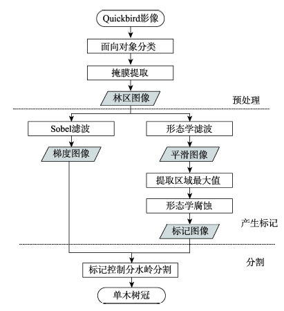
Fig.1 The flowchart of the method used in this study

图1 研究方法流程图

3.1 预处理

由于树冠周围包括林下禾草、裸土和阴影等多种地物对象,在树冠提取时容易造成干扰。为提高提取精度先通过分类,提取出树冠范围,再进行分割。
传统的基于像元的分类方法是一种基于光谱特征统计的分类方法,是在对所选择的样本进行统计的基础上,根据统计的特征值对影像进行聚类的一种方法[17],随着遥感影像分辨率的提高,单个像元所包含的信息逐渐减少,从而给传统的基于像元的分类方法带来了新的挑战。面向对象的影像分析方法是指将影像对象作为基本单元,根据空间或光谱特征将影像分割成离散的区域或集合[18],更适合于信息丰富的高分辨率影像。本文借助(ENVI EX)模块进行面向对象分类。面向对象分类分为分割、合并和监督分类3个步骤。分割时采用基于边缘分割的算法,能够快速、准确地根据邻近像素亮度、纹理、颜色等特性产生多尺度分割结果。合并时采用Full Lambda-Schedule算法,该方法在结合光谱和空间信息的基础上迭代合并邻近的小斑块。尺度是指关于多边形对象异质性最小的阈值,它决定生成最小多边形的级别大小,过大的阈值会使特征类似的不同地物会分为一类,过小的阈值则使有些特征对象会分为多个部分。因此合理的尺度是分类成功的关键,分割和合并尺度的选择范围为0-100。对于疏林区影像,当尺度阈值小于50时,影像中产生很多碎斑,大树冠可能被分成多个部分;当尺度阈值大于50时,分割多边形较大,导致几个小树冠被识别为一个树冠,故本文设置分割尺度为50。针对密林区,经过多次试验得到最适合分割尺度为20。同样,合并时疏林区经反复试验后选取合并尺度为75,密林区选取合并尺度为60。本文经过反复试验选取分割和合并的最适参数,如表1所示。然后基于分割结果选取训练样本,采用K邻近法进行监督分类。若单纯地利用ENVI EX,大量相邻树冠没有被分开,因此需要进行进一步的分割。接着将分类后的林地作为掩膜,只提取样地中的林地部分,用于后续分割。
Tab.1 The selection of parameters in object-oriented classification

表1 面向对象分类参数选取表

样地 分割尺度 合并尺度
疏林区 50 75
密林区 20 60

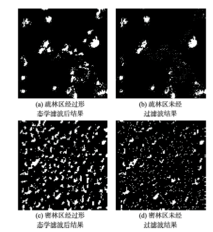
3.2 标记控制分水岭分割

3.2.1 形态学滤波

标记的正确选取是分割成功的关键。由于树冠内部的不规则性,直接提取树冠的局部最大值容易产生噪声和伪树冠顶点,导致过分割。因此,在探测局部最大值之前必须对原始图像加以平滑,以有效地消除图像中的噪声。传统的线性滤波器如高斯滤波器等可以保留图像的低频分量,过滤高频分量,达到平滑图像,消除噪声的目的,但不能有效地抑制纹理细节对后续图像分割带来的过分割影响。相比于传统的线性滤波方法,数学形态学的非线性滤波方式更适合图像分割及与图像几何特性相关方面的应用[19]
形态学重建开闭运算能够去除细密纹理和噪声引起的伪局部极值,同时不会产生边界偏移,保留轮廓信息,因此本文采用形态学重建开闭运算作进一步的平滑处理。形态学重建开闭运算在测地腐蚀和测地膨胀的基础上,对图像 f ( x , y ) 和参考图像 r ( x , y ) 和圆盘形结构元素B,其测地学膨胀定义[20]如式(1)所示。
D B i + 1 ( f , r ) = Min [ ( D B i B ) , r ] D B i ( f , r ) = Min [ ( f B ) , r ] ( i = 1,2 , ) (1)
类似地, f ( x , y ) 的测地学腐蚀定义如式(2) 所示。
E B j + 1 ( f , r ) = Max [ ( E B j Θ B ) , r ] E B j ( f , r ) = Max [ ( f Θ B ) , r ] ( j = 1,2 , ) (2)
以上运算均为迭代运算,当迭代次数达到预定值或满足 D B i ( f , r ) = D B i + 1 ( f , r ) E B j ( f , r ) = E B j + 1 ( f , r ) 时,迭代终止。重建开运算是以原图像的腐蚀作为标记图像做膨胀重建,如式(3)所示;重建闭运算以原图像的膨胀作为标记图像做腐蚀重建,如式(4)所示。
O B ( rec ) ( f , r ) = D B ( rec ) [ ( f B ) , r ] (3)
C B ( rec ) ( f , r ) = E B ( rec ) [ ( f B ) , r ] (4)
式中: 分别代表形态学开和闭运算; D B ( rec ) E B ( rec ) 分别代表形态学测地膨胀和腐蚀收敛时的结果。形态学重建过程可恢复图像中那些没有完全被开(闭)运算所滤除的成分的边界,消除比结构元素小的高(低)灰度细节,并且不会产生新边界和边界偏移。同时,运用形态学开闭重建能够修正区域极大值和极小值,减少因细节和噪声干扰造成的分水线位置偏移和因局部极小值过多造成的分水岭过分割现象。
结构元素的尺寸和形状对滤波效果有重要影响,如果结构元素过大,一些较小的树冠会被移除;如果结构元素过小,一些树枝会被当作树冠,造成过分割。结构元素的尺寸应小于所有待分割地物尺寸的最小值,形状应与所需提取特定地物相同。因此,本文结构元素采取圆盘形,尺寸小于最小树冠半径。由于旱柳树冠较大,刺槐的树冠较小,故不能采用同一尺寸。经多次试验确定旱柳的结构元素大小为3个像元,刺槐的结构元素大小为1个像元。本文中对林区先后进行了形态学开闭重建,经上述处理后的图像树冠内部纹理细节可得到有效抑制,并消除了背景噪声,在探测局部最大值可获得更好的结果(图2)。
Fig.2 The result of regional maximum detection

图2 局部最大值探测结果图

3.2.2 标记生成
虽然滤波消除了大部分的噪声和局部极值,但由于阔叶树树冠结构的不规则性,仍然存在一些干扰,直接进行分水岭分割时,容易在同一树冠内部形成多个分割对象,造成过分割。通过预先提取树冠顶点部分作为标记,能够大大减少伪树冠顶点造成的干扰。根据树冠结构的光谱特征,树冠顶点往往具有较高的反射值,而树冠边缘反射值很低。因此,可以假设树冠顶点位于图像的局部最大值所对应的像元处,即分水岭变换的起点——集水盆。
局部最大值是指连通且灰度值相同的像元,满足周围像素值均小于该连通区域的值。定位局部最大值的具体过程为:通过3×3大小的0和1组成的矩阵,其中1值代表中心元素的邻域位置,逐一比较中心像素灰度值与其4邻域像元灰度值,输出一幅二值图像,将大多数的无关小区域标记为0,同时将4邻域连通的局部最大值区域标记为1。局部最大值探测的结果有时会接近树冠边缘,并且存在很多噪声,因此需要加入滤波以消除孤立的噪声,缩小边界,得到更精确的局部最大值。常用的方法包括形态学腐蚀和均值滤波。实验表明,形态学腐蚀对旱柳图像的处理效果较好,但对刺槐图像的处理效果欠佳。而运用半径为1的圆形窗口对刺槐图像进行均值滤波,可以获得较好的局部最大值图像。
3.2.3 分割
分水岭分割方法基于数学形态学思想,针对图像的梯度图进行分割。其原理如下:首先将图像视作地形表面,每个像元的灰度值对应为地形表面的高程,局部极小值及其影响区域称为集水盆;然后在集水盆最低处穿孔,将其垂直浸入水中。当水慢慢浸入并淹没表面时,在不同汇水盆地之间修建大坝防止其聚合,这些大坝就形成分水岭[21]。标记控制分水岭变换是对分水岭变换的改进。标记控制分水岭算法从参考图象的全局极小值点开始,假定当前值为h+1,每个极小值小于或等于h的集水盆会被分配一个唯一标记。对当前值为h+1的像元,若其邻域有已经标记过的像元,则给它分配相同标记,若周围没有一个像元是标记过的,则被认为是一个新的集水盆,并给它分配一个新标记。反复进行标记,直到图像中的每一个像元都归类到某个集水盆。即属于某个对象区域为止,分水岭变换则完成[22]。树冠灰度图像可以看作是分水岭模型的倒置,树冠中心对应集水盆最低点,其树冠边缘对应分水岭。但是由于阔叶树树冠内部结构的复杂性,同一树冠内部存在多个局部极值,直接应用分水岭方法极易产生过分割现象。目前,针对过分割现象的有效改进方法是结合标记控制的分水岭分割,即通过预先提取树冠顶点作为标记,将标记强制应用为局部最低值,再进行分水岭变换,这种方法可以有效去除伪树冠顶点,提高精度。
分水岭算法一般针对梯度图像进行。由于图像灰度值在树冠边缘发生突变,因此利用梯度图像可以更好地探测树冠边缘。本文中利用Sobel算子进行水平和垂直2个方向的滤波,求取模值,产生梯度图像。然后利用经过上述步骤产生的标记图像,通过强制最小运算(Minima Imposition)进行梯度重建。强制最小运算是基于形态学中腐蚀算子的图像处理方法,其目的是使局部最小区域仅出现在标记的位置,而其他像元值相应地进行“上推”,进而删除其他的局部最小区域[23],然后对重建的梯度图像进行分水岭分割,得到最终结果。

4 实验结果及精度评价

4.1 实验结果

结合2幅郁闭度不同的QuickBird影像,首先利用ENVI EX 4.8软件,采用面向对象的方式将目标图像分为林地和非林地2类,提取出原始影像中的树用于后续的树冠提取。然后利用Matlab编程,实现本文所述的基于标记控制的分水岭变换,对林区图像进行分割。最终结果如图3、4所示。
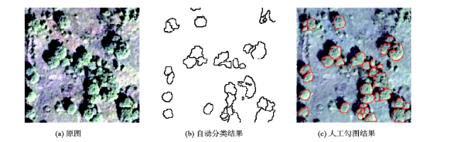
Fig.3 The result for the sparse forest area

图3 疏林区树冠提取结果

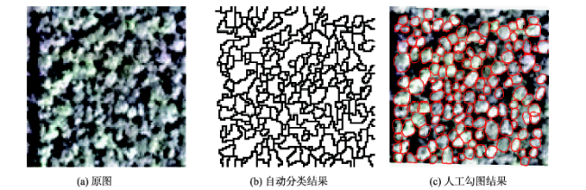
Fig.4 The result for the dense forest area

图4 密林区树冠提取结果

4.2 精度评价

由于缺少地面调查数据,本文的分割结果精度分析通过手动方式进行,即通过人工目视解译的方式获取参考图,参考图被认为是正确的分割结果,将分割结果与参考图进行对比分析,通过二者的差异度来衡量分割结果的质量。位于边缘的树冠形状不完整,无法应用分水岭算法,因此精度评价不包括边界上的树冠。根据参考图中树冠与分割图中树冠的空间关系,将参考图树冠分为5类[5]:匹配、接近匹配、丢失、合并、分割。其中,匹配指参考树冠和分割树冠的重叠部分占各自的50%以上;接近匹配指参考树冠和分割树冠的重叠部分占其中一方的50%以上;漏分指参考树冠内一半以上的面积内没有出现目标树冠;合并指多个参考树冠在分割图中被一个树冠所代替;分割指一个参考树冠一半以上的面积被多个分割树冠占据。匹配和接近匹配被认为是正确分割结果,丢失和合并对应漏分误差,分割对应错分误差,则分割准确率、召回率和F测度分别定义如式(5)-(7)所示。
A d = Nc Nd × 100 % (5)
A r = Nc Nr × 100 % (6)
F = 2 A r A d A r + A d (7)
式中: A d 代表准确率; A r 代表召回率; F 代表F测度; Nc 表示被正确分割的树冠个数; Nr 表示参考图中树冠个数总数; Nd 代表自动分割结果中树冠个数总数。精度统计结果如表2所示。疏林区主要树种为旱柳,共分出29棵树冠,人工勾绘出35棵,其中匹配的树冠有26棵,接近匹配的有2棵,因此疏林区准确率达到96.6%,召回率达到80.0%,F测度为87.8%。密林区中主要树种为刺槐,共分出114棵树冠,人工勾绘出124棵树冠,其中匹配的树冠有75棵,接近匹配的有3棵,准确率达到68.4%,召回率达到62.9%,F测度为65.5%。
Tab.2 The accuracy statistics of different forest areas (%)

表2 精度统计表(%)

样地 匹配 接近匹配 丢失 合并 分割 目视解译
疏林 26 2 6 1 0 35
密林 75 3 38 5 2 124

注:疏林区F测度为87.8%,密林区F测度为65.5%

5 结语

目前的单木树冠提取方法都针对特定的树种和立地条件,并不适用于所有林分。由于阔叶林其林冠形状不规则性和内部复杂性,提取精度不高,研究较少。本文提出了一种基于面向对象分类和标记控制分水岭分割的高空间分辨率遥感影像阔叶林树冠提取方法,通过实验表明:本文所用方法在疏林区提取精度较高,F测度达到87.8%,可有效地替代人工解译,不仅可以大大地减少解译时间、节约劳动成本,还能够确保树冠提取精度。在密林区,由于林地郁闭度较高,树冠之间相互重叠遮挡,相邻两刺槐树冠纹理特征、光谱值无明显差异,导致单株树冠的边缘难以检测,树冠分割精度相比疏林区较低,F测度为65.5%。
关于高空间分辨率影像单木树冠提取的精度评价方法目前还没有统一的标准,再加上影像的选择和森林条件、树种的区别,因此很难比较不同方法精度的高低。关于精度评价主要涉及2个方面:参考图像的选择和树冠提取精度。参考图像的选择分为地面调查数据和人工解译2种,在地面调查数据很难获取的情况下,可以由具有相关专业背景的其他人员进行目视解译,最好能有3名及以上人员参与目视解译,增加验证的可靠性。有地面调查数据的情况下,精度评价一般分为树冠数量探测和树冠轮廓描绘2方面,树冠数量提取精度通过比较正确分割树冠个数和总探测树冠个数或地面调查树冠个数的比值。树冠轮廓提取误差可以通过求自动提取的冠幅和真实冠幅之间的均方根值或回归分析后的r2来表示。如果没有地面调查数据,参照树冠通常通过人工勾绘得到。通过一一对比分割树挂和参考树冠的关系进行验证。另外,一种评价分割精度的方法是建立像素混淆矩阵,不过工作量大,适合像元较少的情况,或通过产生随机点验证。本文借鉴Jing[8]的方法,认为分割结果与参考图重叠部分超过50%为正确划分的结果,进行了较严格的精度验证。由于黄河三角洲人工刺槐林区芦苇丛生,工作人员很难进入其中测量单木参数,本文借助人工勾绘结果作为参考对树冠分割方法进行了评价,未来的工作拟构建模拟数据进行辅助评价。
单木树冠提取的数据源主要基于航空影像,成本较高,而针对卫星影像的研究较少。但近几年,具有更高空间分辨率的商用卫星陆续发射成功,并且卫星影像容易获取,能够满足大部分单木树冠提取的需求,基于高空间分辨率遥感的单木树冠自动提取方法将会得到快速发展。

The authors have declared that no competing interests exist.

[1]
Pouliot D A, King D J, Bell F W, et al.Automated tree crown detection and delineation in high-resolution digital camera imagery of coniferous forest regeneration[J]. Remote Sensing of Environment, 2002,82(2):322-334.Ensuring successful forest regeneration requires an effective monitoring program to collect information regarding the status of young crop trees and nearby competing vegetation. Current field-based assessment methodology provides the needed information, but is costly, and therefore assessment frequency is low. This often allows undesirable forest structures to develop that do not coincide with management objectives. Remote sensing techniques provide a potentially low-cost alternative to field-based assessment, but require the development of methods to easily and accurately extract the required information. Automated tree detection and delineation algorithms may be an effective means to accomplish this task. In this study, a tree detection-delineation algorithm designed specifically for high-resolution digital imagery of 6-year-old trees is presented and rigorously evaluated. The algorithm is based on the analysis of local transects extending outward from a potential tree apex. The crown boundary is estimated using the point of maximum rate of change in the transect data and a rule base is applied to ensure that the point is contextually suitable. This transect approach is implemented in both the tree-detection and crown-delineation phases. The tree-detection algorithm refines the results of an initial local maximum filter by providing an outline for each detected tree and retaining only one local maximum value within this outline. The crown-delineation algorithm is similar to the detection algorithm, but applies a different rule set in creating a more detailed crown outline. Results show that the algorithm's tree-detection accuracy was better than that using commonly applied fixed-window local maximum filters; it achieved a best result of 91%. For the crown-delineation algorithm, measured diameters from delineated crowns were within 17.9% of field measurements of diameter at the crown base on an individual tree basis and within 3% when averaged for the study. Tests of image pixel spacings from 5 to 30 cm showed that tree-detection accuracy was stable except at the lowest (30-cm) resolution where errors were unacceptable. Delineated crown-diameter accuracy was more sensitive to image resolution, decreasing consistently and nonlinearly with increasing pixel spacing. These results highlight the need for very high resolution imagery in automated object-based analysis of forest regeneration.

DOI

[2]
Chen Q, Baldocchi D, Gong P, Isolating individual trees in a savanna woodland using small footprint lidar data[J]. Photogrammetric Engineering & Remote Sensing, 2006,72(8):923-932.This study presents a new method of detecting individual treetops from lidar data and applies marker-controlled watershed segmentation into isolating individual trees in savanna woodland. The treetops were detected by searching local maxima in a canopy maxima model (CMM) with variable window sizes. Different from previous methods, the variable windows sizes were determined by the lower-limit of the prediction intervals of the regression curve between crown size and tree height. The canopy maxima model was created to reduce the commission errors of treetop detection. Treetops were also detected based on the fact that they are typically located around the center of crowns. The tree delineation accuracy was evaluated by a five-fold, cross-validation method. Results showed that the absolute accuracy of tree isolation was 64.1 percent, which was much higher than the accuracy of the method, which only searched local maxima within window sizes determined by the regression curve (37.0 percent).

DOI

[3]
Wang L, Gong P, Biging G S.Individual tree-crown delineation and treetop detection in high-spatial-resolution aerial imagery[J]. Photogrammetric Engineering & Remote Sensing, 2004,70(3):351-357.CiteSeerX - Document Details (Isaac Councill, Lee Giles, Pradeep Teregowda): The cost of forest sampling can be reduced substantially by the ability to estimate forest and tree parameters directly from aerial photographs. However, in order to do so it is necessary to be able to accurately identify individual treetops and then to define the region in the vicinity of the treetop that encompasses the crown extent. These two steps commonly have been treated independently. In this paper, we derive individual tree-crown boundaries and treetop locations under a unified framework. We applied a two-stage approach with edge detection followed by markercontrolled watershed segmentation. A Laplacian of Gaussian edge detection method at the smallest effective scale was employed to mask out the background. An eight-connectivity scheme was used to label the remaining tree objects in the edge map. Subsequently, treetops are modeled based on both radiometry and geometry. More specifically, treetops are assumed to be represented by local radiation maxima and also to be located near the center of the tree-crown. As a result, a marker image was created from the derived treetop to guide a watershed segmentation to further differentiate touching and clumping trees and to produce a segmented image comprised of individual tree crowns. Our methods were developed on a 256- by 256-pixel CASI image of a commercially thinned trial forest. A promising agreement between our automatic methods and manual delineation results was achieved in counting the number of trees as well as in delineating tree crowns.

DOI

[4]
Ke Y, Quackenbush L J.Individual tree crown detection and delineation from high spatial resolution imagery using active contour and hill-climbing methods[C]. Proceedings of 2009 ASPRS Annual Conference, American Society of Photogrammetry and Remote Sensing, 2009:9-13.

[5]
Gougeon F A.A crown-following approach to the automatic delineation of individual tree crowns in high spatial resolution aerial images[J]. Canadian Journal of Remote Sensing, 1995,21(3):274-284.

[6]
Pollock R J.The automatic recognition of individual trees in aerial images of forests based on a synthetic tree crown image model[D]. Concordia University, 1996.

[7]
Brandtberg T, Walter F.Automated delineation of individual tree crowns in high spatial resolution aerial images by multiple-scale analysis[J]. Machine Vision and Applications, 1998,11(2):64-73.This paper presents an automatic multiple-scale algorithm for delineation of individual tree crowns in high spatial resolution infrared colour aerial images. The tree crown contours were identified as zero-crossings, with convex grey-level curvature, which were computed on the intensity image for each image scale. A modified centre of curvature was estimated for every edge segment pixel. For each segment, these centre points formed a swarm which was modelled as a primal sketch using an ellipse extended with the mean circle of curvature. The model described the region of the derived tree crown based on the edge segment at the current scale. The sketch was rescaled with a significance value and accumulated for a scale interval. In the accumulated sketch, a tree crown segment was grown, starting at local peaks, under the condition that it was inside the area of healthy vegetation in the aerial image and did not trespass into a neighbouring crown segment. The method was evaluated by comparison with manual delineation and with ground truth on 43 randomly selected sample plots. It was concluded that the performance of the method is almost equivalent to visual interpretation. On the average, seven out of ten tree crowns were the same. Furthermore, ground truth indicated a large number of hidden trees. The proposed technique could be used as a basic tool in forest surveys.

DOI

[8]
Jing L, Hu B, Noland T, et al.An individual tree crown delineation method based on multi-scale segmentation of imagery[J]. ISPRS Journal of Photogrammetry and Remote Sensing, 2012,70:88-98.A forest consists of multi-scale branches, tree crowns, and tree clusters. Similar to small tree crowns in shape and scale, branches normally cause over-segmentation of imagery when a watershed segmentation approach is used to segment imagery for tree crown delineation. In order to eliminate such over-segmentation, a new method for individual tree crown delineation from optical imagery was proposed based on multi-scale filtering and segmentation in this study. In this method, the dominant sizes of tree crowns are first determined; Gaussian filters are designed to fit the three-dimensional radiometric shapes of multi-scale tree crowns; the grayscale image is smoothed using the Gaussian filters and segmented using the watershed segmentation approach; and finally, the resulting multiple segmentation maps are integrated together to generate a tree crown map. In an experiment on aerial imagery of forests consisting of multi-scale tree crowns, the proposed method yielded high-quality tree crown maps. (C) 2012 International Society for Photogrammetry and Remote Sensing, Inc. (ISPRS) Published by Elsevier B.V. All rights reserved.

DOI

[9]
覃先林,李增元,易浩若.高空间分辨率卫星遥感影像树冠信息提取方法研究[J].遥感技术与应用,2005(2):228-232.树冠是树木的重要组成部分,是树木进行光合作用的重要场所,是其生长所需能量的重要来源之一,因而人们常常通过对树冠的研究来监测树木的长势、预测树木的生物量,甚至判定木材的材性等.商用高空间分辨率卫星数据的出现,为人们利用遥感技术研究树冠结构提供了新的数据源.以覆盖实验区的QuickBird数据为例,开展了基于高空间分辨率的卫星影像树冠大小信息提取方法的研究.在对QuickBird影像处理的基础上,采用面向对象的图像分析方法,通过基于样本的模糊分类方法有效地提取了影像中的树冠大小信息.同时,为推动高空间分辨率卫星影像在我国林业和生态环境建设中的应用打下了坚实基础.

DOI

[ Qin X L, Li Z Y, Yi H R.Extraction method of tree crown using high-resolution satellite Image[J]. Remote Sensing Technology & Application, 2005,2:228-232. ]

[10]
Liu Q S, Liu G H, Yao L.Changes of Robinia Pseudoacacia planted forest in the Yiqianer nature reserve following the super storm surge of sept. 1992[C]. The 3rd International Yellow River Forum on Sustainable Water Resources Management and Delta Ecosystem Maintenance, 2007:116-120.

[11]
姚玲,刘高焕,刘庆生,等.利用影像分类分析黄河三角洲人工刺槐林健康[J].武汉大学学报·信息科学版,2010,35(7):863-867.用监督分类方法提取出Landsat TM影像中的刺槐林区域,将归一化植被指数NDVI、归一化水分指数NDWI、土壤调节植被指数SAVI、修正的土壤调节植被指数MSAVI和K-T变换应用于刺槐林影像,用聚类分析将刺槐林分成4个等级的树冠活力。实测结果表明,通过树冠活力来分类,NDWI分类精度最高,达到82.5%。

[ Yao L, Liu G H, Liu Q S, et al.Remote sensing monitoring the health of artificial Robinia pseudoacacia forest[J]. Geomatics & Information Science of Wuhan University, 2010,35(7):863-867. ]

[12]
刘庆生,刘高焕,姚玲.利用Landsat ETM+数据检测人工刺槐林冠健康[J].遥感技术与应用,2008(2):142-146,109.通过发展一种基于单景Landsat TM/ETM+数据客观、可靠、简单易行的人工刺槐林冠健康检测方法,为人工刺槐林地健康监测和管理服务。以孤岛林场的一块近乎纯人工刺槐林地为试验区,首先选择当地刺槐完全展叶时的2000年5月2日的Landsat ETM+数据进行几何精校正,并将第6波段重采样为与第1~5和7波段相同的空间分辨率30 m,然后将波段1~5和7波段数据校正到大气顶层反射率以减少传感器和数据获取方面的影响,利用第6波段计算亮度温度。接着进行3种组合的ISODATA非监督分类(健康或轻度枯梢、中度枯梢、重度枯梢或死亡或灌丛、非植被):波段1~5和7,归一化后的缨帽变换Tasseled Cap Transform(TCT)绿度和湿度成分,归一化后的缨帽变换Tasseled Cap Transform(TCT)绿度、湿度成分和亮度温度。结果发现,增加了第6波段信息(亮度温度)的第3种组合对人工刺槐林冠健康检测更有效。

DOI

[ Liu Q S, Liu G H, Yao L.Detection of Robinia pseudoacacia planted forest canopy health using Landsat ETM+ image data[J]. Remote Sensing Technology & Application, 2008,2:142-146,109. ]

[13]
Wang H, Pu R, Zhu Q, et al.Mapping health levels of Robinia pseudoacacia forests in the Yellow River delta, China, using IKONOS and Landsat 8 OLI imagery[J]. International Journal of Remote Sensing, 2015,36(4):1114-1135.The largest artificial forests in the Yellow River delta of China have been infected by dieback diseases. Over the past several decades, this has caused a large amount of mortality of forests in this area. Timely and accurate information on the health levels of the forests is crucial to improving local ecological and economic conditions. Remote sensing has been demonstrated to be a useful tool to map forest diseases over a large area. In this study, IKONOS and Landsat 8 Operational Land Imager (OLI) sensor data were collected for comparing their capability of accurately mapping health levels of the artificial forests. There were three health levels (i.e. healthy, medium dieback, and severe dieback) based on explicit tree crown symptoms. After the IKONOS and OLI images were preprocessed, both spatial and spectral features were extracted from the IKONOS and OLI imagery, and a maximum likelihood classification method was used to identify and map health levels of forests. The experimental results indicate that the IKONOS sensor has greater potential for identifying and mapping forest health levels. Furthermore, texture features, especially texture variance, derived from the IKONOS panchromatic band, contributed greatly to the accuracy of classification results, achieving an overall accuracy (OA) of 96% for the IKONOS sensor and an OA of 88% for the OLI 2, which used both OLI spectral and IKONOS spatial features, compared with an OA of 74% for the OLI sensor alone. Our results indicate that the texture features extracted from high resolution imagery can improve the classification accuracy of health levels of planted forests with a regular spatial pattern. Our experimental results also demonstrate that classification of an image with a spatial resolution similar to, or finer than, tree crown diameter outperforms that of relatively coarse resolution imagery for differentiating living tree crowns and understorey dense green grass.

DOI

[14]
张珍珍,王红.基于卫星IKONOS影像的黄河三角洲人工刺槐林健康状况分类[J].科学技术与工程,2014,(33):73-79.对刺槐林生长状况的准确分类制图,是刺槐林生长动态监测和枯梢退化原因分析的基础,对指导防护林建设、更新以及研究区其它树种的植被重建具有重要的意义。研究以黄河三角洲地区刺槐林为对象,采用2013年6月9日IKONOS影像为数据源,利用决策树分类器对归一化植被指数和土壤调节植被指数定义一组规则提取出刺槐林地分布范围,制作刺槐林地掩膜,创建灰度共生矩阵来区分健康树冠和林下禾草。结合实地样方调查信息,选取感兴趣区进行监督分类。刺槐林的三个健康度由原位的5个树冠条件指标决定。分类结果表明,刺槐林健康状况分类结果与实地样方数据具有较好的一致性,利用混合矩阵进行精度评价,总精度达到84.3159%,Kappa系数为0.7652。

DOI

[ Zhang Z Z, Wang H.Health situation classification of artificial Robinia pseudoacacia forests from Yellow River Delta based on IKONOS[J]. Science Technology & Engineering, 2014,33:73-79. ]

[15]
宗秀影,刘高焕,乔玉良,等.黄河三角洲湿地景观格局动态变化分析[J].地球信息科学学报,2009,11(1):91-97.在RS和GIS技术的支持下,以黄河三角洲1986,1996,2006年的三期TM影像为数据源,利用遥感图像处理软件对近代黄河三角洲湿地信息进行了提取.借助于地理信息系统软件和景观生态学软件,我们对20年来黄河三角洲湿地景观格局的动态变化,以及影响其格局动态变化的驱动力进行了分析.结果表明:(1)近20年来,人工湿地面积有了大幅度的增加,而天然湿地的比重在降低.其中,滩涂和柽柳灌草丛景观明显萎缩.(2)一些重要的景观格局指数的计算结果表明,20世纪90年代以来,黄河三角洲湿地景观斑块个数、香农多样性指数、香农均匀度指数一直在增加.黄河三角洲湿地景观的破碎化程度在加剧,斑块类型更加多样化,湿地景观中没有明显的优势类型且各斑块类型在景观中均匀分布.(3)湿地与湿地、湿地与非湿地之间发生着类型转化.其中,18.1%的芦苇草甸转化为农田;26.6%的翅碱蓬草甸转化为盐田;11.9%的芦苇沼泽转化为芦苇草甸.(4)在黄河三角洲湿地演化的过程中,受到自然和人为方面演化驱动力的共同作用.其中,自然因素主要有:黄河断流、泥沙淤积和自身演替动力等.人为驱动力主要为农田开垦、滩涂的开发与围垦、油田开发和人工建筑等.

[ Zong X Y, Liu G H, Qiao Y L, et al.Study on dynamic changes of wetland landscape pattern in Yellow River Delta[J]. Geo-information Science, 2009,11(1):91-97. ]

[16]
刘庆生,刘高焕,黄翀.黄河三角洲人工刺槐林枯梢调查统计分析[J].林业资源管理,2011(5):79-83.在野外样地调查数据的基础上,对黄河三角洲人工刺槐枯梢特征进行了统计分析,结果表明:研究地区人工刺槐林断顶、枯梢及死亡率为41.4%.依据样地树高 和胸径调查数据,将239棵人工刺槐分为三类,调查表明,随着树龄的增加人工刺槐枯梢率由18.2%上升到36.3%,该地区人工刺槐枯梢程度服从 (4.04,2.27)的正态分布,中度、重度和死亡刺槐占枯梢及死亡刺槐的66.7%,这表明黄河三角洲人工刺槐枯梢严重,需要及时进行人工刺槐林枯梢 监测相关机理研究与综合管理.

DOI

[ Liu Q S, Liu G H, Huang C.Statistic analysis on planted Robinia pseudoacacia forest dieback in the Yellow River Delta[J]. Forest Resources Management, 2011,5:79-83. ]

[17]
张存. 基于Quick Bird影像的面向对象信息提取方法比较实验研究[D].沈阳:东北大学,2009.

[ Zhang C.Comparative experimentation study on Information extraction of object-oriented based on QuickBird image[D]. Shenyang: Northeastern University, 2009. ]

[18]
张聪颖,田淑芳.基于ENVI Zoom面向对象的高分辨率影像的道路提取[J].中国科技信息,2010(23):96-97.随着科技的发展,遥感技术已经形成向高空间分辨率和高光谱分辨率发展的趋势,并且取得了很好的效果,如QUICKBIRF影像全色波段的分辨率已经达到0.61 m,WORLDVIEW影像全色波段的分辨率达到0.5m.因此,高分辨率遥感影像能很好的突出的地物细节信息和结构纹理信息,利用这一特点,可以采用面向对象技术,提取道路信息.而传统的道路提取方法只依据道路的光谱信息.利用面向对象技术对试验区进行提取.首先,对影像进行预处理,然后对影像进行分割;其次,利用道路的光谱、纹理、结构信息,构建道路对象的知识库,从而实现道路信息的提取.所以,面向对象技术是提取高分辨率影像信息的一个重要发展趋势.

DOI

[ Zhang C Y, Tian S F.Road extraction based on ENVI Zoom from high-resolution image using objected-oriented Technology[J]. China Science and Technology Information, 2010,23:96-97. ]

[19]
罗玲,解梅,陈杉.基于多尺度形态滤波的分水岭图像分割方法[J].计算机辅助设计与图形学学报,2004(2):168-173.采用多尺度形态滤波器对输入噪声图像及滤波后图像的梯度图像进行平滑,实现了消除噪声、简化图像、保持物体重要轮廓信息的作用.最后,给出一种改进的快速区域合并算法优化分割结果.实验证明,采用文中分割方法可以获得很好的分割结果。

DOI

[ Luo L, Xie M, Chen S.Watershed segmentation based on multi-scale morphological filtering[J]. Journal of Computer Aided Design & Computer Graphics, 2004,2:168-173. ]

[20]
王小鹏,罗进文.基于形态学梯度重建的分水岭分割[J].光电子·激光,2005(1):98-101.提出一种基于形态学梯度重建的分水岭图像分割方法.该方法在形态 学梯度图像的基础上,利用形态学开闭重建运算对梯度图像进行重建,在保留重要区域轮廓的同时去除了细节和噪声.避免了标准分水岭存在的过分割现象及传统形 态学开闭运算先平滑原始图像,后进行分水岭变换而造成的区域轮廓位置偏移.仿真实验证明,无论从消除过分割还是区域轮廓定位等性能方面,该方法均具有较好 的分割效果.整个分割过程无需进行分割后的区域合并处理,降低了分割的复杂性;且分割过程只需选择合适的结构元素大小,增强了算法的灵活性.

DOI

[ Wang X P, Luo J W.Watershed segmentation based on morphological gradient reconstruction[J]. Journal of Optoelectronics Laser, 2005,1:98-101. ]

[21]
Vincent L, Soille P.Watersheds in digital spaces: an efficient algorithm based on immersion simulations[J]. IEEE Transactions on Pattern Analysis & Machine Intelligence, 1991(6):583-598.A fast and flexible algorithm for computing watersheds in digital gray-scale images is introduced. A review of watersheds and related motion is first presented, and the major methods to determine watersheds are discussed. The algorithm is based on an immersion process analogy, in which the flooding of the water in the picture is efficiently simulated using of queue of pixel. It is described in detail provided in a pseudo C language. The accuracy of this algorithm is proven to be superior to that of the existing implementations, and it is shown that its adaptation to any kind of digital grid and its generalization to n-dimensional images (and even to graphs) are straightforward. The algorithm is reported to be faster than any other watershed algorithm. Applications of this algorithm with regard to picture segmentation are presented for magnetic resonance (MR) imagery and for digital elevation models. An example of 3-D watershed is also provided.

DOI

[22]
马丽红,张宇,邓健平.基于形态开闭滤波二值标记和纹理特征合并的分水岭算法[J].中国图象图形学报,2003,8(1):80-86.为了防止分水岭算法过分割问题,研究了一种基于形态处理和纹理分 析的图象分水岭分割方法,该方法是在分水岭算法的基础上,首先对形态梯度图象运用形态开闭滤波器组的方法来获得较好的参考图象,然后将提取的二值化初始分 割结果作为区域标记来进行分割.另外,为了获得整体目标,还定义了一个基于纹理特征的一致性和对比度的检验准则,并将其作为区域合并的根据.该方法应用于 多个视频序列初始目标分割的结果表明,形态滤波器组的引入很好地防止了过分割,并证明基于纹理特征均匀性和对比度的准则对分割区域进行进一步的纹理合并是 行之有效的.

DOI

[ Ma L H, Zhang Y, Deng J P.A target segmentation algorithm based on opening-closing binary marker on watersheds and texture merging[J]. Journal of Image & Graphics, 2003,8(1):80-86. ]

[23]
Soille P.Morphological image analysis: principles and applications[M]. Berlin, Germany: Springer Science & Business Media, 2013.

文章导航

/