
基于可持续性视角的建设用地适宜性评价及其应用
作者简介:喻忠磊(1987-),男,博士生,研究方向为经济地理、土地利用与区域可持续发展。E-mail: yzlei87@163.com
收稿日期: 2015-09-25
要求修回日期: 2016-05-13
网络出版日期: 2016-10-25
基金资助
国家“十二五”科技支撑计划项目(2012BAJ22B05)
An Approach of Suitability Evaluation for Construction Land and Spatial Conflict Analysis based on Sustainability Perspective
Received date: 2015-09-25
Request revised date: 2016-05-13
Online published: 2016-10-25
Copyright
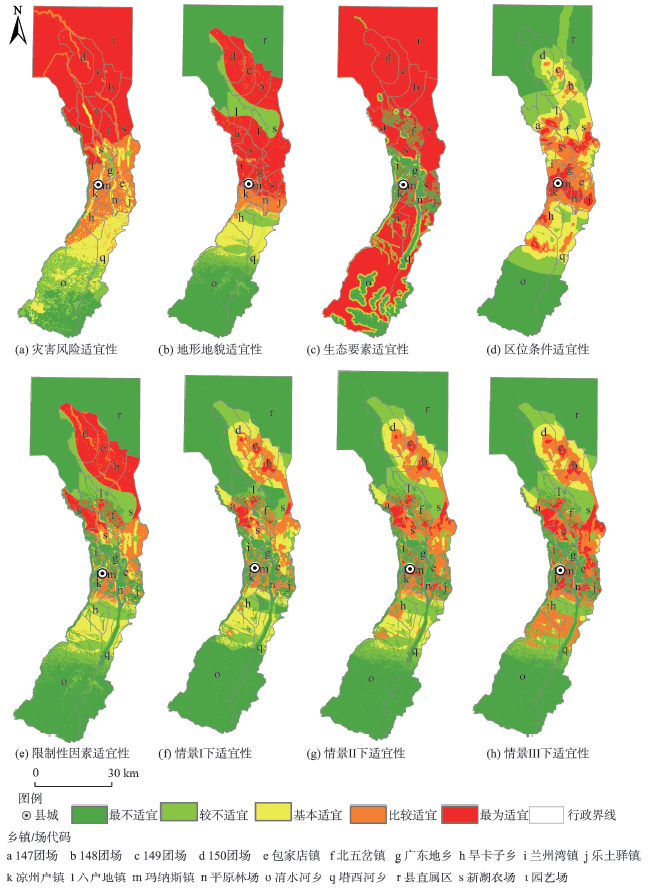
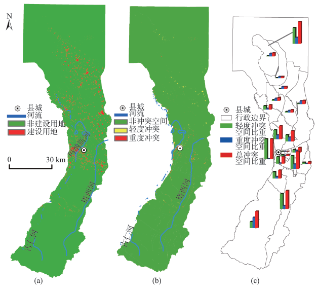
建设用地适宜性是土地资源利用与管理决策的依据。本文基于土地利用可持续性界定建设用地适宜性内涵,从灾害风险、地形地貌、生态环境和区位条件4个维度,构建了较规范的适宜性指标体系;针对已有评价方法的不足,构建了整合极值法、条件函数法、线性加权综合的“多要素分布式算法——情景矩阵”评估框架;进而基于适宜性识别冲突空间,以空间冲突面积占总建设用地面积的比重作为空间冲突强度来刻画区域建设空间布局的合理性与可持续性。本文以新疆玛纳斯县为例开展研究,结果表明玛纳斯县适宜建设空间(达230 km2以上)约占全县总面积的26%;最适宜和比较适宜性建设用地主要分布于中部及中北部乡镇及农(团)场驻地附近,基本适宜建设区主要分布在比较适宜建设空间的外围及中南部山前平原地带;该县冲突空间达4.21 km2,占建成区面积的22.74‰;冲突空间主要分布在河流沿岸和中部城镇化发展区;南部、北部的生态脆弱区及中部工业化发展区的乡镇空间冲突强度也较高。研究表明,本文提出的建设用地适宜性评估框架与方法逼近客观现实,简单易行,能弥补以往评价方法的不足;适宜性在空间冲突分析与可持续性土地利用管理中具有较好的应用价值。
喻忠磊 , 庄立 , 孙丕苓 , 梁进社 , 张文新 . 基于可持续性视角的建设用地适宜性评价及其应用[J]. 地球信息科学学报, 2016 , 18(10) : 1360 -1373 . DOI: 10.3724/SP.J.1047.2016.01360
Land suitability for construction is fundamentally useful to land use planning and management. In this study, we defined a connotation of land suitability for construction based on land use sustainability, and constructed a standardized indicator system of suitability from four dimensions of disaster risk, terrain, ecological environment and location. Against the deficiency of the exiting evaluation method, we constructed an evaluation framework of multifactor-distributed algorithm and scenario matrices integrating extreme value methods, conditional function methods and linear weighted comprehensive methods. This study discerned the conflict space based on suitability and used the proportion of conflict area of total built-up area as space conflict intensity to measure the reasonability and sustainability of spatial distribution. This study took Manasi County, Xinjiang Province as a case and the results indicated that: (1) the potential suitable construction land is very sufficient, the total area suitable for construction is more than 230 km2 (around 26% of the total area of the county). The land with suitability grade 4 and 5 mainly distribute in Manasi town, Letuyi town, Farm 147, Xinhu Farm and the farms in northern area. The land with rank 3 distributes in outlying regions of land of rank over 3 and the piedmont plain in central south. (2) the space with conflicts is up to 4.21 km2, 22.74‰ of the built-up area. The spatial conflicts are mainly distributed along the Manasi River and Taxi River, in the environmental fragile zone and in the central industrialized urban area of the county as well. This case study suggested that the framework and evaluation methodology of construction land suitability proposed in this paper is viable and close to the reality. It can offset the disadvantages of existing evaluation methods for construction land suitability. In addition, the suitability assessment of land for construction can play an important role in spatial conflict analysis.
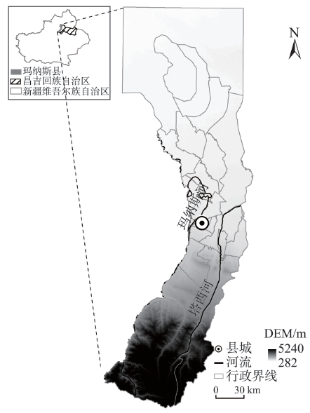
Fig. 1 Location of study area图1 研究区位置图 |
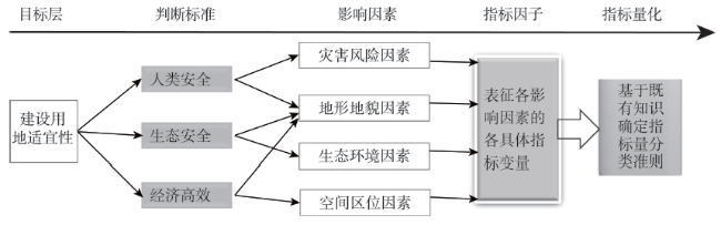
Fig. 2 The approach to indicator system of land suitability for construction图2 建设用地适宜性指标体系构建思路框图 |
Tab.1 Indicators of land suitability for construction表1 建设用地适宜性评价指标体系 |
| 影响因素 | 指 标 | 指标说明 | 指标性质 |
|---|---|---|---|
| 灾害风险因素 (Hazard) | 地质灾害风险 (Geologic hazard) | 根据地质灾害风险等级划分适宜性等级,高风险=1,较高风险=2,中等风险=3,较低风险=4,低风险=5 | 限制性 |
| 断裂带避让 (Fault zone) | 断裂带两侧15 m范围内禁止进行建设活动[36],将避让范围区域赋值为0(不可建设),否则赋为1(可以建设) | 限制性 | |
| 洪水风险 (Flood) | 根据洪水风险等级划分适宜性等级,高风险=1,较高风险=2,中等风险=3,较低风险=4,低风险=5 | 限制性 | |
| 地形地貌条件 (Terrain) | 高程(DEM) | 据玛纳斯县建设用地的海拔分布情况,设置500 m以下为5,500~800 m为4,800~1400 m为3,1400~2500 m为2,大于2500 m为1; | 限制性 |
| 坡度(Slope) | 5°以下为5,5°~8°为4,8°~15°为3,15°~25°为2,25°以上为1[14、36] | 限制性 | |
| 地貌类型(Landforms) | 低海拔冲积平原=5,低海拔冲积台地、中海拔冲积、洪积平原=4,中海拔中起伏山地=3,低海拔风积地貌、中海拔黄土梁峁、中高海拔大起伏山地=2,高海拔极大起伏山地、现代冰川、沙漠=1[14、36] | 限制性 | |
| 生态环境因素 (Eco) | 河流(River) | 考虑到区内河流等级较低,以100 m作为带宽向外缓冲5级,分别赋值为1、2、3、4、5[18] | 限制性 |
| 湖泊和水库(Lake) | 距离水面小于500 m为1,500~1000 m为2,1000~1500 m为3,1500~2000 m为4,2000 m以外区域为5[21] | 限制性 | |
| 葡萄园(Vineyard) | 葡萄园禁止占用,赋值为0,非葡萄园区赋值为1 | 限制性 | |
| 基本农田(Farmland) | 基本农田应严格保护,基本农田覆盖区赋为0,否则为1 | 限制性 | |
| 湿地公园(Wet land) | 据相关研究[14],对于湿地公园以400 m作为带宽向外缓冲5级,分别赋值为1(含湿地公园)、2、3、4、5 | 限制性 | |
| 森林公园(Forest park) | 参考相关研究[14]以400m作为带宽向外缓冲5级,分别赋值为1(含森林公园)、2、3、4、5 | 限制性 | |
| 空间区位条件 (Location) | 到县城中心的距离 (Dis_county) | 参考县城到县域边界的最远距离进行划分,本研究以15 m为半径向外扩展;15 km以内为5,15-30 km为4,依次类推; | 引导性 |
| 距主要道路的距离(Dis_road) | 以线性加权综合法对距国、省、县道的距离得分进行综合,再用自然断裂点法进行分级。对于国道、省道,1.5 km缓冲范围内最为适宜,赋为5,1.5~3 km赋为4,3~4.5 km赋为3,4.5~6 km赋为2,6 km以外赋为1;对于县道,0.5 km范围内赋为5,0.5~1 km为4,1~1.5 km为3,1.5~2 km赋为2,2 km以外赋为1 | 引导性 | |
| 到乡镇镇区的距离(Dis_town) | 以3 km为带宽,向外进行5级缓冲分析,由近到远分别赋为5、4、3、2、1 | 引导性 |
Tab.2 The judgment matrix of suitability for construction land表2 建设用地适宜性判断矩阵 |
| 区位因素 | 限制因素 | ||||||||||||||||||
|---|---|---|---|---|---|---|---|---|---|---|---|---|---|---|---|---|---|---|---|
| 最为适宜5 | 比较适宜4 | 基本适宜3 | 较不适宜2 | 最不适宜1 | |||||||||||||||
| I | II | III | I | II | III | I | II | III | I | II | III | I | II | III | |||||
| 最不适宜1 | 2 | 2 | 2 | 2 | 2 | 2 | 1 | 1 | 2 | 1 | 1 | 1 | 1 | 1 | 1 | ||||
| 较不适宜2 | 3 | 3 | 3 | 2 | 3 | 3 | 2 | 2 | 3 | 1 | 2 | 2 | 1 | 1 | 1 | ||||
| 基本适宜3 | 4 | 4 | 4 | 3 | 4 | 4 | 3 | 3 | 4 | 2 | 2 | 2 | 1 | 1 | 1 | ||||
| 比较适宜4 | 5 | 5 | 5 | 4 | 4 | 5 | 3 | 4 | 4 | 2 | 2 | 2 | 1 | 1 | 1 | ||||
| 最为适宜5 | 5 | 5 | 5 | 4 | 5 | 5 | 4 | 4 | 4 | 2 | 2 | 3 | 1 | 1 | 1 | ||||
注:I为最小开发情景;II为适度开发情景;III表示最大开发情景 |
Fig.3 Results of evaluation of land suitability for construction in Manasi图3 玛纳斯县建设用地适宜性评价结果 |
Fig. 4 Distributions of built up area and space with conflict in Manasi county图4 玛纳斯县建设用地与冲突空间 |
Tab.3 Amount of land with different suitability in Manasi county表3 玛纳斯县土地资源开发建设适宜性等级的规模结构 |
| 情 景 | 最不 适宜 | 较不 适宜 | 基本 适宜 | 比较 适宜 | 最为 适宜 | |
|---|---|---|---|---|---|---|
| 最小开发 | 面积/km2 | 592.17 | 86.87 | 118.71 | 92.03 | 20.27 |
| 比重/(%) | 65.07 | 9.55 | 13.04 | 10.11 | 2.23 | |
| 适度开发 | 面积/km2 | 537.56 | 141.48 | 83.52 | 113.94 | 33.55 |
| 比重/(%) | 59.07 | 15.55 | 9.18 | 12.52 | 3.69 | |
| 最大开发 | 面积/km2 | 537.52 | 129.60 | 57.45 | 124.86 | 60.62 |
| 比重/(%) | 59.06 | 14.24 | 6.31 | 13.72 | 6.66 | |
Tab. 4 Area of spatial conflict and spatial conflict intensity表4 各乡镇冲突空间面积及空间冲突强度 |
| 乡镇/团场 | 建设用地总面积/km2 | 重度冲突 | 轻度冲突 | 合计 | |||||
|---|---|---|---|---|---|---|---|---|---|
| 面积/km2 | 比重/(‰) | 面积/km2 | 比重/(‰) | 面积/km2 | 比重/(‰) | ||||
| 园艺场 | 0.87 | 0.00 | 0.21 | 0.08 | 88.27 | 0.08 | 88.48 | ||
| 县直属 | 3.37 | 0.09 | 27.17 | 0.24 | 70.24 | 0.33 | 97.40 | ||
| 塔西河乡 | 1.99 | 0.03 | 13.95 | 0.13 | 66.02 | 0.16 | 79.97 | ||
| 平原林场 | 2.43 | 0.05 | 19.91 | 0.14 | 56.58 | 0.19 | 76.49 | ||
| 清水河乡 | 4.54 | 0.21 | 46.20 | 0.12 | 27.08 | 0.33 | 73.28 | ||
| 兰州湾镇 | 11.42 | 0.20 | 17.48 | 0.46 | 39.88 | 0.66 | 57.36 | ||
| 广东地乡 | 4.72 | 0.09 | 18.06 | 0.13 | 28.40 | 0.22 | 46.46 | ||
| 旱卡子乡 | 4.99 | 0.04 | 7.83 | 0.14 | 28.64 | 0.18 | 36.47 | ||
| 凉州户镇 | 6.57 | 0.01 | 1.17 | 0.19 | 29.17 | 0.20 | 30.33 | ||
| 147团场 | 11.23 | 0.05 | 4.19 | 0.18 | 15.67 | 0.22 | 19.87 | ||
| 包家店镇 | 12.79 | 0.12 | 9.18 | 0.15 | 11.65 | 0.27 | 20.84 | ||
| 新湖农场 | 40.38 | 0.52 | 12.94 | 0.08 | 1.87 | 0.60 | 14.80 | ||
| 六户地镇 | 7.68 | 0.08 | 10.08 | 0.03 | 3.69 | 0.11 | 13.77 | ||
| 150团场 | 13.54 | 0.17 | 12.25 | 0.02 | 1.76 | 0.19 | 14.01 | ||
| 乐土驿镇 | 9.11 | 0.02 | 2.55 | 0.07 | 7.52 | 0.09 | 10.07 | ||
| 北五岔镇 | 6.13 | 0.05 | 8.28 | 0.02 | 2.89 | 0.07 | 11.17 | ||
| 148团场 | 17.81 | 0.17 | 9.68 | 0.00 | 0.00 | 0.17 | 9.68 | ||
| 玛纳斯镇 | 11.50 | 0.02 | 2.13 | 0.05 | 4.21 | 0.07 | 6.34 | ||
| 149团场 | 13.09 | 0.07 | 5.63 | 0.01 | 0.43 | 0.08 | 6.07 | ||
| 试验站 | 0.85 | 0.00 | 0.00 | 0.00 | 0.21 | 0.00 | 0.21 | ||
| 玛纳斯县 | 185.00 | 1.98 | 10.72 | 2.22 | 12.01 | 4.21 | 22.74 | ||
The authors have declared that no competing interests exist.
| [1] |
[
|
| [2] |
[
|
| [3] |
[
|
| [4] |
[
|
| [5] |
|
| [6] |
[
|
| [7] |
[
|
| [8] |
[
|
| [9] |
[
|
| [10] |
[
|
| [11] |
[
|
| [12] |
[
|
| [13] |
[
|
| [14] |
[
|
| [15] |
|
| [16] |
|
| [17] |
[
|
| [18] |
|
| [19] |
[
|
| [20] |
[
|
| [21] |
[
|
| [22] |
[
|
| [23] |
[
|
| [24] |
[
|
| [25] |
|
| [26] |
[
|
| [27] |
[
|
| [28] |
[
|
| [29] |
|
| [30] |
|
| [31] |
[
|
| [32] |
[
|
| [33] |
[
|
| [34] |
[
|
| [35] |
[
|
| [36] |
[
|
| [37] |
[
|
| [38] |
[
|
| [39] |
[
|
| [40] |
[
|
| [41] |
[
|
/
| 〈 |
|
〉 |