
高速公路对路域植被影响的时空格局变化遥感监测分析
作者简介:郭云开(1958-),男,湖南桃源人,博士,主要从事遥感技术理论及其应用的教学与科研工作。E-mail: guoyunkai226@163.com
收稿日期: 2015-10-19
要求修回日期: 2015-12-25
网络出版日期: 2016-11-20
基金资助
国家自然科学基金项目(41471421、41171397)
Analysis of Expressway′s Impact on Vegetation in Its Spatial and Temporal Variation Based on Remote Sensing Monitoring
Received date: 2015-10-19
Request revised date: 2015-12-25
Online published: 2016-11-20
Copyright
植被覆盖动态监测及与生态环境变化的响应是陆地生态系统研究的重要内容。本文以不同时相的TM遥感影像为信息源,基于辐射传输模型PROSAIL,定量反演了不同时期高速公路两侧植被的叶面积指数,以反演的叶面积指数作为路域植被生长状况的监测指标,对实验区路域植被的生长状况进行了时空格局变化的动态遥感监测研究。研究表明:① 在时间上,路域植被的生长状况在高速公路开通后5年内受到的影响相对最大;② 在空间上,离高速公路越近的植被的生长状况受到的影响较大,离高速公路越远的植被的生长状况受到的影响较小。本研究为监测路域植被生长状况提供了重要的方法,为指导路域植被的生态恢复与保护提供了可靠的基础。
关键词: 叶面积指数(LAI); PROSAIL模型; 路域植被; 定量遥感
郭云开 , 苟叶培 . 高速公路对路域植被影响的时空格局变化遥感监测分析[J]. 地球信息科学学报, 2016 , 18(11) : 1537 -1543 . DOI: 10.3724/SP.J.1047.2016.01537
Vegetation dynamics and their coupled relations with ecology are current research hot spots in exploring how the terrestrial ecosystems respond to the climate systems. We have obtained the vegetation leaf area index on both sides for the expressway in the research area, based on the simulations which use the PROSAIL and TM images as the information source. We studied the dynamic changes of road vegetation growth status with LAI from aspects of time and space. The results are shown as follows. (1) The temporal change of vegetation growth pattern in the expressway region shows that: the temporal growth condition of the roadside vegetation is influenced heavily in the first 5-year period after a new expressway has opened. (2) The spatial change of vegetation growth pattern in the expressway region shows that: the spatial growth condition of the roadside vegetation is heavily impacted within the regions that are closer to the expressway, while the vegetation located far from the expressway is mildly affected. Generally, this research provides reliable basic data for guiding the vegetation restoration and protection.
Key words: Leaf Area Index (LAI); PROSAIL model; road vegetation; remote sensing
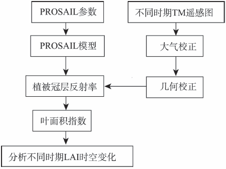
Fig. 1 Technical route图1 技术路线 |
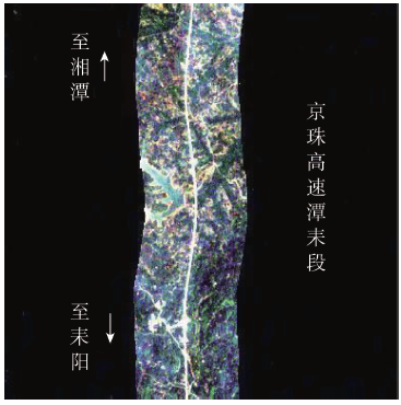
Fig. 2 Research area图2 研究区 |
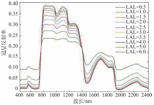
Fig. 3 Simulated canopy reflectances under different LAIs图3 不同LAI下模拟的冠层反射率 |
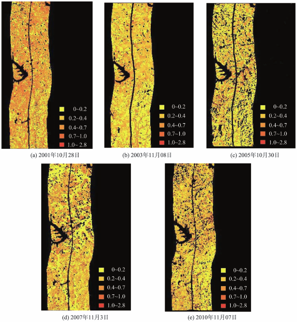
Fig. 4 Pictures of LAI distribution in different years图4 不同年份叶面积指数分级图 |
Fig. 5 The inversion LAI and the measured LAI图5 反演的LAI与实测LAI |
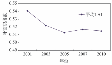
Fig. 6 Changes of the average LAI onboth sides of the highway图6 高速公路两侧植被平均LAI变化情况 |
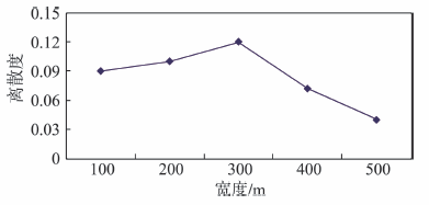
Fig. 7 Dispersion of LAI in different regions图7 不同区域内LAI的离散度 |
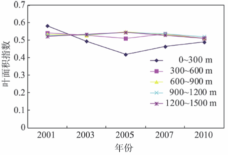
Fig. 8 Changes of the average LAI indifferent regions of road图8 道路两侧不同区域平均LAI变化情况 |
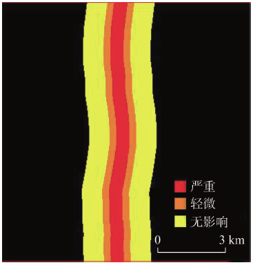
Fig. 9 Impact of highway on the vegetation from both sides图9 高速公路对两侧植被影响情况 |
The authors have declared that no competing interests exist.
| [1] |
|
| [2] |
[
|
| [3] |
[
|
| [4] |
[
|
| [5] |
[
|
| [6] |
[
|
| [7] |
[
|
| [8] |
[
|
| [9] |
[
|
| [10] |
|
| [11] |
[
|
| [12] |
|
| [13] |
|
| [14] |
|
| [16] |
|
| [17] |
[
|
| [18] |
[
|
| [19] |
[
|
/
| 〈 |
|
〉 |
