
河南省GlobeLand30数据精度评价及对比分析
作者简介:马京振(1993-),男,硕士生,研究方向为多源数据融合与处理。E-mail: zb50mjz@163.com
收稿日期: 2016-06-01
要求修回日期: 2016-07-08
网络出版日期: 2016-11-20
基金资助
国家自然科学基金项目(41571399、41071297)
Accuracy Assessment and Comparative Analysis of GlobeLand30 Dataset in Henan Province
Received date: 2016-06-01
Request revised date: 2016-07-08
Online published: 2016-11-20
Copyright
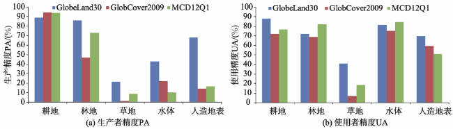
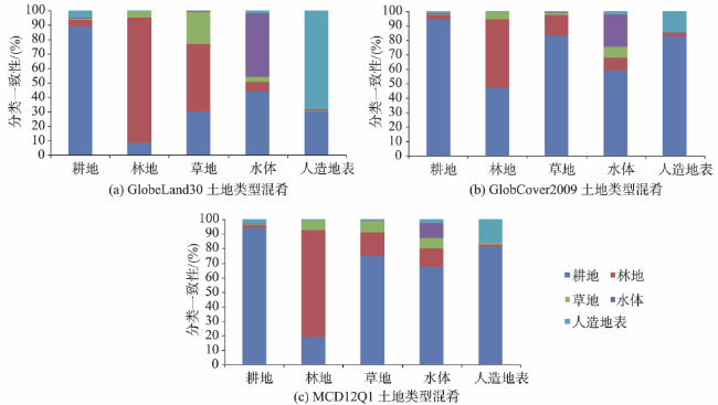
全球地表覆盖数据在气候变化研究、地理国情监测、生态环境保护等方面发挥着重要作用,2014年中国国家基础地理信息中心推出了全球最高30 m分辨率的地表覆盖遥感制图数据产品GlobeLand30。本文以2010年1:10万中国土地利用数据为参考,采用空间统计、面积一致性以及误差矩阵等分析方法,对河南省GlobeLand30、GlobCover2009、MCD12Q1数据进行精度评价和对比分析研究,结果表明:① 3种地表覆盖数据对河南省土地构成的描述基本一致,即以耕地、林地为主,草地、水体和人造地表为辅,但分类土地面积存在大小不同的差异;② GlobeLand30的总体精度和Kappa系数最高,MCD12Q1次之,GlobCover2009最低。3种数据中耕地和林地的精度均较高,草地的精度较差,GlobeLand30中水体和人造地表的生产者精度远高于其他2种数据,使用者精度相差不大;③ 地表覆盖数据与参考数据在空间上存在类型混淆情况,混淆主要发生于林地、草地、水体、人造地表与耕地之间,GlobeLand30的混淆程度要低于其他2种数据。
关键词: 地表覆盖; GlobeLand30; 误差矩阵; 精度评估; 对比分析
马京振 , 孙群 , 肖强 , 温伯威 . 河南省GlobeLand30数据精度评价及对比分析[J]. 地球信息科学学报, 2016 , 18(11) : 1563 -1572 . DOI: 10.3724/SP.J.1047.2016.01563
Global land cover data plays an important role in climate change research, geographical conditions monitoring and ecological environment protection. It' s of great significance to produce and evaluate the global land cover data at a specific spatial scale. In 2014, the National Geomatics Center of China (NGCC) produced GlobeLand30 of the remote sensing mapping product with the world’s highest 30 m resolution. In this paper, the 1:100 000 land use data of Henan Province was used as the reference data to validate global land cover data of GlobeLand30, GlobCover2001 and MCD12Q1. The accuracy assessment and comparative analysis of these data were conducted with three methods, including spatial statistics, area relevance and consistency, and confusion matrix. The results show that the three land cover products have a good consistency for description of land forms with the reference data, and the area relevance is higher than 0.9. Cropland and forestland are the main land cover types, followed by grassland, water body and artificial surface, but the classified land has different area in these products. By evaluating accuracy of the three land cover products, the overall accuracy and Kappa coefficient of GlobeLand30 are the highest, followed by MCD12Q1 and those of GlobCover2009 are the lowest. In terms of specific land type, although cropland and forestland have high precision in these products, the accuracy of grassland classification is poor. The producer accuracy of water body and artificial surface in GlobeLand30 is much higher than the other two products, but the difference of the user accuracy is small. The three land cover products show the spatial confusion especially in forestland, grassland and cropland with the reference data. The confusion degree of GlobeLand30 is lower than the other two kinds of data. This paper illustrates that GlobeLand30 has higher accuracy than other products and it will play a more and more important role in many fields. Not only can the methods and conclusions in this paper pave the way for further research in other areas, but also they can have great significance on promoting the application and value of GlobeLand30. Moreover, because of the spatial resolution of GlobeLand30 is much higher than other land cover products, the use of GlobeLand30 for further application and research is the focus in the next step. In addition, there are a lot of remote sensing images, vector data, and other multi-source data and how to improve the quality of the global land cover data is one of the problems that should be considered.
Key words: land cover; GlobeLand30; error matrix; accuracy assessment; comparative analysis
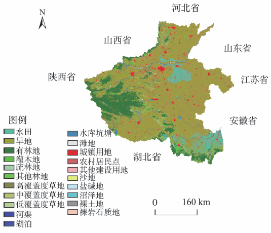
Fig. 1 The land use map of Henan Province in 2010图1 河南省2010年土地利用分布图 |
Tab. 1 The characteristics comparison of three land cover products表1 3种地表覆盖数据的特点对比 |
| 产品名称 | 制作单位 | 卫星影像 | 时相/年 | 分类方法 | 分类数量 | 分辨率/m |
|---|---|---|---|---|---|---|
| GlobeLand30 | 国家基础地理 信息中心 | Landsat TM5、ETM+、HJ-1 | 2000、2010 | 像元-对象-知识 (POK方法) | 10 | 30 |
| GlobCover | 欧洲空间局 | MERIS | 2005、2009 | 神经网络分类 | 22 | 300 |
| MCD12Q1 | 美国波士顿大学 | Terra/MODIS | 2001-2015 | 决策树分类 | 17 | 500 |
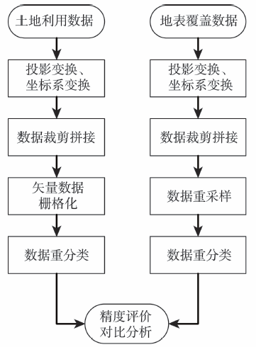
Fig.2 The flow chart of processing land cover land use data图2 地表覆盖数据和土地利用数据处理流程图 |
Tab. 2 Land type reclassification and corresponding relation表2 土地类型重分类和对应关系表 |
| 统一分类 | 2010年土地利用数据 | GlobeLand30 | GlobCover2009 | MCD12Q1 |
|---|---|---|---|---|
| 1耕地 | 11水田、12旱地 | 10耕地 | 11水田、14旱地、20耕地与植被镶嵌体 | 12耕地 |
| 2林地 | 21有林地、22灌木地、23疏林地、24其他林地 | 20森林、 40灌木地 | 30自然植被与耕地镶嵌体、40常绿阔叶或半落叶阔叶林、50常绿阔叶林、60落叶阔叶林、70常绿针叶林、90常绿针叶或落叶针叶林、100针阔混交林、110林地/灌木/草地镶嵌、130灌木 | 1常绿针叶林、2常绿阔叶林、3落叶针叶林、4落叶阔叶林、5混交林、6稠密灌丛、7稀疏灌丛、14自然植被/耕地镶嵌体 |
| 3草地 | 31高覆盖度草地、32中覆盖度草地、33低覆盖度草地 | 30草地 | 120草地/森林/灌木镶嵌、140草地 | 8木本热带稀树草原、9热带稀树草原、10草地 |
| 4水体 | 41河渠、42湖泊、43水库坑塘、45滩涂、46滩地、64沼泽 | 50湿地、 60水体 | 160被水淹没的阔叶林、170永久被水淹没的阔叶林或灌木、180被水淹没的草地、210水体 | 0水体、11永久湿地 |
| 5人造地表 | 51城镇用地、52农村居民点、53其他建设用地 | 80人造地表 | 190人工地表或附属区域 | 13城市和建筑区 |
| 6其他 | 61沙地、62戈壁、63盐碱地、65裸土地、66裸岩石质地、67其他、44永久性冰川雪地 | 70苔原、90裸地、100冰川和 永久积雪 | 150稀疏植被(<15%)、200裸地、220冰川和永久积雪 | 15冰川和积雪、16裸地或稀疏植被 |
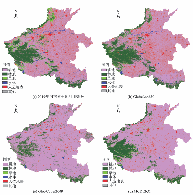
Fig. 3 Map of land cover reclassification in Henan Province图3 河南省重分类后的土地覆盖图 |
Tab. 3 Area statistics and error coefficient of different land types for the land use and land cover data in Henan province表3 河南省土地利用数据和地表覆盖数据不同类型土地面积统计及误差系数 |
| 土地类型 | 土地利用数据 | GlobeLand30 | GlobCover2009 | MCD12Q1 | |||||
|---|---|---|---|---|---|---|---|---|---|
| 面积/km2 | 面积/km2 | 误差系数C/(%) | 面积/km2 | 误差系数C/(%) | 面积/km2 | 误差系数C/(%) | |||
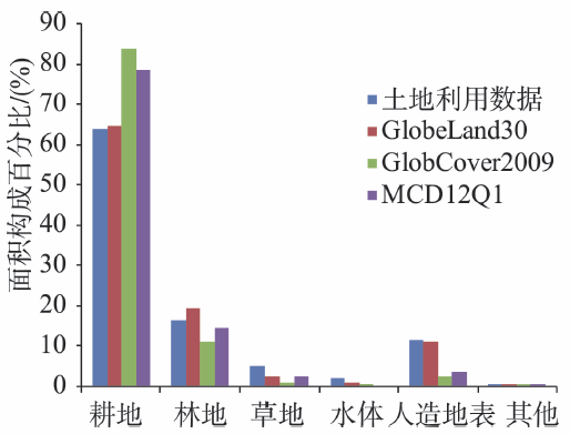
| 耕地 | 107 202.08 | 108 484.06 | 1.20 | 140 166.68 | 30.75 | 131 406.38 | 22.58 | ||
| 林地 | 27 382.47 | 32 618.58 | 19.12 | 18 636.51 | 31.94 | 24 364.52 | 11.02 | ||
| 草地 | 8952.73 | 4755.97 | 46.88 | 2162.03 | 75.85 | 4257.22 | 52.45 | ||
| 水体 | 4061.01 | 2147.33 | 47.12 | 1204.70 | 70.33 | 487.58 | 87.99 | ||
| 人造地表 | 19 390.31 | 18 917.68 | 2.44 | 4741.39 | 75.55 | 6396.34 | 67.01 | ||
| 其他 | 11.41 | 76.38 | - | 88.68 | - | 87.96 | - | ||
Fig. 4 Comparison of the area of different land types forland use and land cover data in Henan province图4 河南省土地利用数据和地表覆盖数据不同类型土地面积的对比 |
Tab. 4 The comparison of accuracy assessment criteria of three land cover products表4 3种地表覆盖数据的相关精度评价指标对比 |
| 地表覆盖数据 | OA/(%) | AD/(%) | QD/(%) | Kappa系数 |
|---|---|---|---|---|
| GlobeLand30 | 81.51 | 14.50 | 3.99 | 0.6550 |
| GlobCover2009 | 70.66 | 9.56 | 19.78 | 0.3306 |
| MCD12Q1 | 75.08 | 10.34 | 14.58 | 0.4640 |
Fig. 5 Comparison of producer accuracy and user accuracy of different land types in the three land cover data图5 3种地表覆盖数据中不同类型土地的PA和UA对比 |
Fig. 6 The confusion degree of different land types in the three land cover products图6 3种地表覆盖数据中不同类型土地的混淆程度 |
The authors have declared that no competing interests exist.
| [1] |
|
| [2] |
|
| [3] |
[
|
| [4] |
|
| [5] |
|
| [6] |
|
| [7] |
|
| [8] |
[
|
| [9] |
[
|
| [10] |
|
| [11] |
[
|
| [12] |
|
| [13] |
|
| [14] |
|
| [15] |
[
|
| [16] |
[
|
| [17] |
[
|
| [18] |
|
| [19] |
|
| [20] |
|
| [21] |
[
|
| [22] |
[
|
| [23] |
|
| [24] |
[
|
| [25] |
[
|
| [26] |
|
/
| 〈 |
|
〉 |