
一种考虑雪粒径变化的积雪面积反演算法
作者简介:王 杰(1984-),男,四川南充人,博士,讲师,主要从事遥感数字图像处理,数据挖掘研究工作。E-mail: wangjie308@mails.ucas.ac.cn
收稿日期: 2016-02-29
要求修回日期: 2016-06-19
网络出版日期: 2017-01-13
基金资助
基金项目:西华师范大学博士科研启动基金项目(412546、412547)
四川省教育厅自然科学重点项目(15ZA150)
国家自然科学基金项目(41101348)
An Algorithm of Snow Cover Fraction Retrieval Considering the Variability of Snow Particle Size
Received date: 2016-02-29
Request revised date: 2016-06-19
Online published: 2017-01-13
Copyright
光谱混合分析能够提取亚像元信息,被广泛地应用于遥感影像目标探测之中。本文针对MODIS积雪遥感影像,基于光谱混合分析框架,利用渐进辐射传输模型建立不同粒径大小的雪反射率光谱库,提出了一种考虑端元变化及二次辐射的雪盖面积反演算法。此算法首先利用渐进辐射传输模型建立不同粒径大小积雪的反射率光谱库,然后使用序贯最大角凸锥方法获取植被、土壤与岩石、阴影的光谱库。在建立各种地物反射率光谱库之后,利用均方根误差最小的方法获取最优端元组合。在此基础上,考虑端元独立辐射以及积雪与其它地物的二次辐射过程,利用稀疏光谱混合模型获取积雪面积与雪粒径大小。实验结果表明:此方法能够同时反演雪粒径与积雪面积,反演的雪粒径相比单波段的渐进辐射传输模型小,反演的积雪面积相比MOD10A1产品精度略微提高。
王杰 , 黄春林 , 郝晓华 . 一种考虑雪粒径变化的积雪面积反演算法[J]. 地球信息科学学报, 2017 , 19(1) : 101 -109 . DOI: 10.3724/SP.J.1047.2017.00101
Snow-cover information is important for a wide variety of scientific studies, water supply and management applications. The NASA Earth Observing System (EOS) Moderate Resolution Imaging Spectroradiometer (MODIS) provides improved capabilities of observing snow cover from space and has been successfully using a normalized difference snow index (NDSI), along with threshold tests, to provide global automated binary maps of snow cover. NDSI and other classification algorithms were used to inverse subpixel information of Snow Cover Fraction (SCF), but these algorithms neglected the relation between SCF and Snow Grain Size (SGZ). The SGZ might affect snow reflectance spectral curves, while most subpixel classification algorithm took advantage of the spectral feature space. The collaborative inversion of SCF and SGZ helped improve the understanding of the physical properties of snow. Meanwhile, it was possible to improve the retrieval accuracy of SCF. The framework of spectral mixture analysis (SMA) was widely used in the target detection of remote sensing images because of its ability to extract subpixel information and SMA could use mathematical methods to model SCF with snow reflectance spectral curves with different snow grain sizes. In this paper, in view of the snow cover with MODIS remote sensing image, based on the framework of spectral mixture analysis, the snow reflectance spectral library with different grain sizes was built by asymptotic radiative transfer (ART) model, and a sparse unmixing algorithm of snow cover fraction retrieval was proposed considering the endmember variability of snow with other materials and bilinear radiative process of endmembers. The ART model had a higher efficiency compared with MIE scatter model. Meanwhile, ART model considered snow grain shape parameters. The majority algorithm of SMA assumed the endmembers independent, which might neglect the interaction of endmembers, while bilinear radiative process of endmembers could consider second-order scattering effects, which had physical meaning. This algorithm firstly used asymptotic radiative transfer model to establish reflectance spectral library with different grain sizes, and Sequential Maximum Angle Convex Cone (SMACC) endmember extraction algorithm was used to obtain the spectral library of vegetation, soil and rock shadow. After the establishment of a variety of spectral libraries, the root mean square error index was used to get the optimal combination of endmembers for each pixel as MODIS Snow Covered Area and Grain Sizes(MODSCAG) model, which could accurately describe the endmember variability. After the optimal endmembers combination obtained, the bilinear radiative process was added into sparse regression spectral mixture analysis to simultaneously obtain snow cover fraction and snow grain size. Experimental results showed that this method could simultaneously inverse the snow grain sizes and snow cover fraction, and the retrieved snow grain sizes is smaller than that from single band of asymptotic radiative transfer model The accuracy of retrieved snow cover fraction is increased slightly compared with MOD10A1 product.
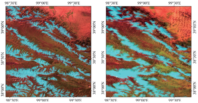
Fig. 1 The TM and MODIS images of the study region (7, 4, 1 bands)图1 研究区2007年9月14日的TM与MOD09GA遥感影像(7、4、1波段组合) |
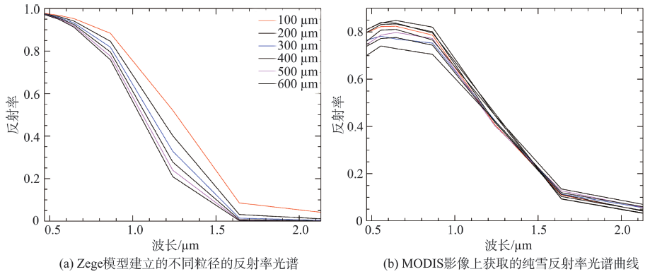
Fig. 2 The comparison between spectral library of radiative transfer model and spectral curves of MODIS images图2 雪光谱库光谱与影像光谱对比 |
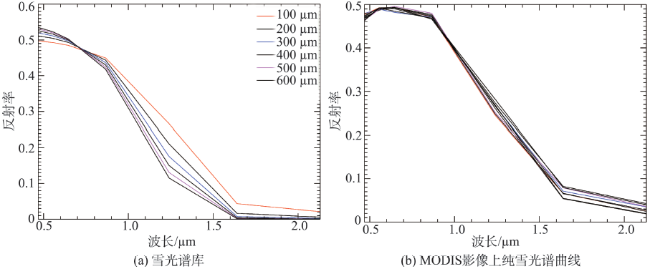
Fig. 3 L2 norm normalized spectral library of radiative transfer model and spectral curves of MODIS images图3 L2范数对光谱库与影像进行规则化 |
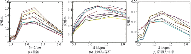
Fig.4 L2 norm normalized vegetation, soil & rock, shade spectral libraries图4 使用L2范数规则化植被、土壤与岩石、阴影光谱库结果 |
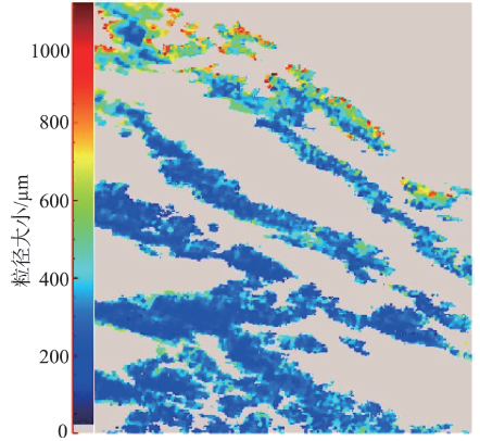
Fig.5 The retrieved snow grain sizes of Zege model for MOD09GA images图5 Zege 模型反演的MOD09GA影像雪粒径 |
Tab.1 The accuracy statistics of different models for snow cover fraction retrieval表1 不同模型积雪面积反演的参数统计 |
| 模型 | RMSE | R | TSCA |
|---|---|---|---|
| Non-CLSUnSAL | 0.2500 | 0.520 | 0.7776 |
| Norm-CLSUnSAL | 0.1820 | 0.570 | 0.9949 |
| MOD10A1 | 0.1954 | 0.569 | 1.0250 |
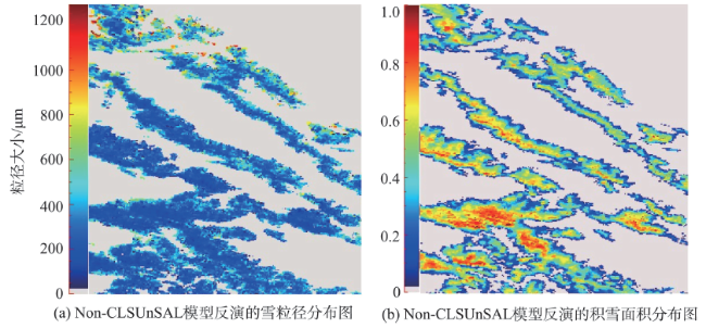
Fig. 6 The unmixing results of Non-CLSUnSAL model图6 Non-CLSUnSAL 模型混合像元分解 |
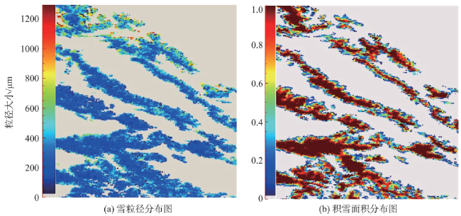
Fig.7 The unmixing results of Norm-CLSUnSAL model图7 Norm-CLSUnSAL 模型混合像元分解 |
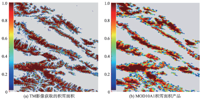
Fig. 8 Two snow cover fraction validation images图8 2种验证影像 |
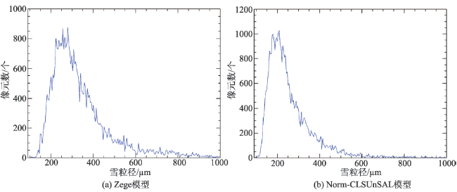
Fig.9 Snow grain sizes distributions of Zege and Norm-CLSUnSAL models图9 Zege模型与Norm-CLSUnSAL模型反演的雪粒径统计分布 |
The authors have declared that no competing interests exist.
| [1] |
|
| [2] |
|
| [3] |
|
| [4] |
|
| [5] |
|
| [6] |
|
| [7] |
|
| [8] |
|
| [9] |
|
| [10] |
|
| [11] |
[
|
| [12] |
[
|
| [13] |
|
| [14] |
|
| [15] |
[
|
| [16] |
|
| [17] |
|
| [18] |
[
|
/
| 〈 |
|
〉 |