
基于主客观分析法的城市生态安全格局空间评价
作者简介:程 鹏(1990-),男,硕士生,研究方向为非再生资源遥感。E-mail:chengpeng4318@163.com
收稿日期: 2016-09-18
要求修回日期: 2017-03-05
网络出版日期: 2017-07-10
基金资助
国家科技支撑计划项目课题(2014BAL04B06)
深圳市基本生态控制线专项调查
深圳市2012年测绘地籍工程计划项目([2012]0365)
The Spatial Evaluation of Urban Ecological Security Pattern Based on Subjective and Objective Analysis
Received date: 2016-09-18
Request revised date: 2017-03-05
Online published: 2017-07-10
Copyright
生态安全是城市生态文明建设的主要目标,是城市经济可持续发展的重要基础,评价城市生态安全格局对于城市规划具有极其重要的作用。本文通过选取典型评价指标,运用生态安全格局客观分析法与主观分析法进行对比分析,建立了包括生态系统服务安全格局、生物多样性保护安全格局、生态敏感性安全格局的生态安全格局综合评价体系,并将该评价体系运用到研究区域,对研究区域生态安全格局的变化趋势进行评价和分析。结果表明:①在基本生态控制线内,低水平、较低水平生态安全格局区域的面积有所增加;在基本生态控制线外,中水平生态安全格局区域的面积有所减少;整体上高水平生态安全格局区域面积基本不变。②生态安全格局主观分析法评价结果主要依赖于专家的评定,本文采用的专家评价方法结果与客观分析法评价结果一致。该评价体系已经应用于研究区域的城乡规划和生态保护中,应用结果表明该评价体系能够较完备地进行城市生态安全格局评价,对城市规划和生态保护具有重要的指导作用。
关键词: 城市生态安全格局; 生态系统服务安全格局; 生物多样性保护安全格局; 生态敏感性安全格局
程鹏 , 黄晓霞 , 李红旮 , 李霞 , 张琳 . 基于主客观分析法的城市生态安全格局空间评价[J]. 地球信息科学学报, 2017 , 19(7) : 924 -933 . DOI: 10.3724/SP.J.1047.2017.00924
Ecological security is one of the main goals to the reconstruction of urban ecological civilization and an important foundation for the sustainable development of urban economy. Therefore, it is significant to evaluate the ecological security pattern of urban for urban planning. This paper selected several typical indexes, made a comparative analysis between objective analysis and subjective analysis method and established an evaluation system of ecological security pattern. To verify the effectiveness of the evaluation system, this paper made an evaluation of the ecological security pattern for the study area using the evaluation system. The result shows that: (1) The Tanglang mountain, Merlin mountain, Yinhu mountain, ecological corridors of Dashahe park and Xiangsilin park all have a low level of security pattern of the value of ecosystem service and ecological sensitivity. (2) The ecological corridors of Dashahe Park and Xiangsilin Park and the dams of Merlin and Changlingpi have a complete biodiversity with a low level of security pattern of the protection of biodiversity and ecological sensitivity. (3) On the basic line of ecological control, the area of the low level and lower level of ecological security pattern increased. Also, the area of the intermediate-level ecological security pattern had a decrease in the area outside the line. On the whole, the high-level ecological security pattern area was substantially constant. (4) The percentage of high level and intermediate level of security pattern is the same in the result made by taking the objective analysis method and the result by taking the subjective analysis method. The former percentage of low-level security pattern is less than the latter. In spite of the difference, they show the similar tendency and results.
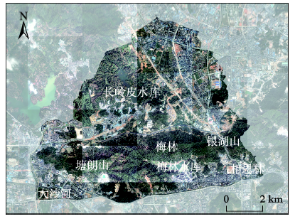
Fig. 1 The image of the research area in 2008图1 2008年研究区域影像 |
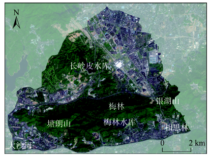
Fig. 2 The image of the research area in 2012图2 2012年研究区域影像 |
Tab. 1 Evaluation index system of ecological security pattern表1 生态安全格局评价指标体系 |
| 目标 | 准则层 | 一级指标 | 二级指标 |
|---|---|---|---|
| 生态安全格局综合评价 | 生态系统服务安全格局 | 氮硫净化 | 林地氮硫净化 |
| 阻滞粉尘 | 叶面积指数、叶面积滞尘量、植被类型、绿地类型、植被覆盖度、生物丰度 | ||
| 降温效应 | 植被覆盖度、绿地降温效应 | ||
| 降噪效应 | 林地降噪 | ||
| 水源涵养 | 植被覆盖度、降雨量、坡度、土地利用类型 | ||
| 产品供应 | 耕地产品供应、园地产品供应 | ||
| 固碳效应 | 植被覆盖度、植被碳密度值 | ||
| 休憩美学 | 土地利用类型、植被覆盖度、覆盖类型美学价值 | ||
| 生物多样性保护安全格局 | 物种多样性 | 生态群落多样性、土地利用类型 | |
| 迁徙通道指标 | 珍稀物种种类、生态线廊道、廊道面积、 | ||
| 生命支撑指标 | 水源地保护等级、水库等级、河道等级 | ||
| 生态敏感性安全格局 | 水土流失 | 土壤侵蚀量、降雨侵蚀力、土壤可蚀性、地形因子、植被覆盖度、土壤保持措施 | |
| 生境敏感性 | 植被类型、土地覆盖类型、保护物种栖息地 | ||
| 地质灾害 | 地质灾害等级指标 |
Tab. 2 Average random consistency index table of 1 to 10 orders表2 1阶到10阶平均随机一致性指标表 |
| 阶数 | 1 | 2 | 3 | 4 | 5 | 6 | 7 | 8 | 9 | 10 |
|---|---|---|---|---|---|---|---|---|---|---|
| RI | 0 | 0 | 0.52 | 0.89 | 1.12 | 1.26 | 1.36 | 1.41 | 1.46 | 1.49 |
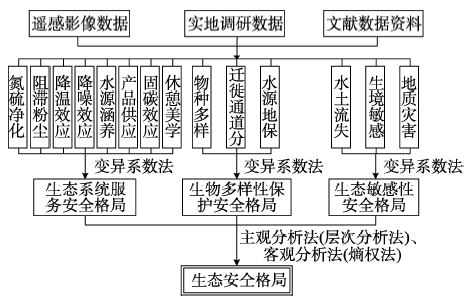
Fig. 3 The technical process of the evaluation of ecological security pattern图3 生态安全格局评价技术流程 |
Tab. 3 The explanation of some indexes表3 部分指标说明 |
| 指标 | 公式计算及说明 |
|---|---|
| 林地氮硫净化 | 林地单位面积净化大气氮硫含量×林地面积 |
| 叶面积指数 | 利用野外实际叶面积测量值,建立其与对应的Pléiades1A/1B高分辨率遥感植被指数NDVI之间的线性关系,进而获得叶面积指数分布图 |
| 植被覆盖度 | ,其中NDVI为归一化植被指数 |
| 耕地产品供应 | 根据深圳市耕地质量等分年度更新评价与监测评价数据将研究区域的耕地按重要性分为5级 |
| 降雨量 | 从气象部门获得降雨量数据进行插值 |
| 坡度 | ,其中h为两点高程最大值,l为两点距离 |
| 生物丰度 | f=(0.35×林地+0.21×草地+0.28×水域湿地+0.11×耕地+0.04×建设用地+0.01×未利用地)/区域面积 |
| 水土流失指标 | A=R×K×LS×C×P,其中R为降雨侵蚀力;K为土壤可侵蚀性因子;LS为地形因子;C为植被覆盖因子;P为土壤保持措施因子 |
Tab. 4 The index weights determined by AHP表4 层次分析法指标权重 |
| 准则层指标 | 生态系统服务安全格局 | 生物多样性保护安全格局 | 生态敏感性安全格局 |
|---|---|---|---|
| 权重 | 0.1958 | 0.3108 | 0.4934 |
Tab. 5 The index weights determined by entropy weight method表5 熵权法指标权重 |
| 准则层指标 | 生态系统服务安全格局 | 生物多样性保护安全格局 | 生态敏感性安全格局 |
|---|---|---|---|
| 权重 | 0.2556 | 0.3490 | 0.3950 |
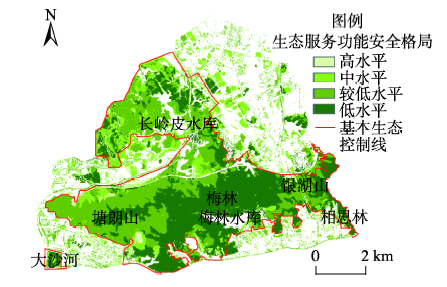
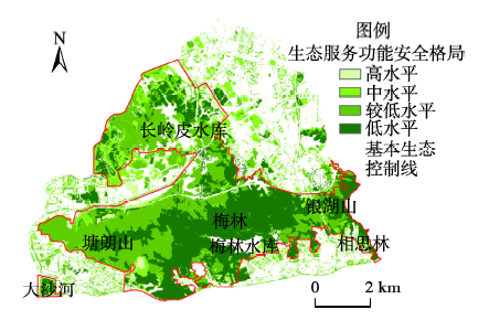
Fig. 4 The security pattern of the value of ecosystem service in 2008图4 2008年生态系统服务安全格局 |
Fig. 5 The security pattern of the value of ecosystem service in 2013图5 2013年生态系统服务安全格局 |
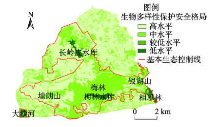
Fig. 6 The security pattern of the biodiversity protection in 2008图6 2008年生物多样性保护安全格局 |
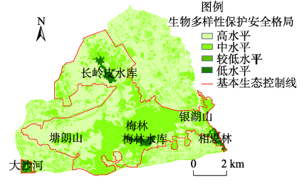
Fig. 7 The security pattern of the biodiversity protection in 2013图7 2013年生物多样性保护安全格局 |
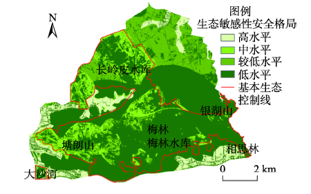
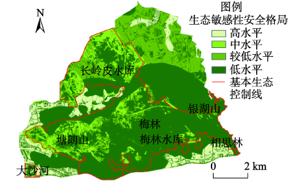
Fig. 8 The security pattern of ecological sensitivity in 2008图8 2008年生态敏感性安全格局 |
Fig. 9 The security pattern of ecological sensitivity in 2013图9 2013年生态敏感性安全格局 |
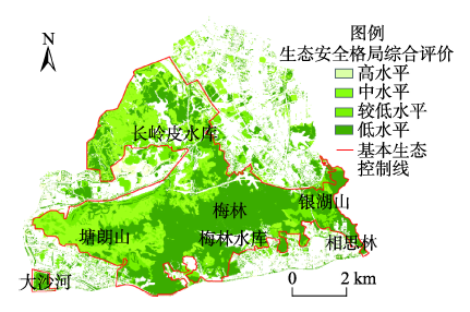
Fig. 10 The evaluation of ecological security pattern by subjective method in 2008图10 2008年主观分析法生态安全格局评价 |
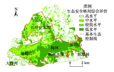
Fig. 11 The evaluation of ecological security pattern by subjective method in 2013图11 2013年主观分析法生态安全格局评价 |
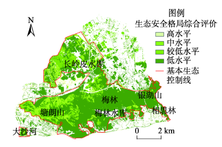
Fig. 12 The evaluation of ecological security pattern by objective method in 2008图12 2008年客观分析法生态安全格局评价 |
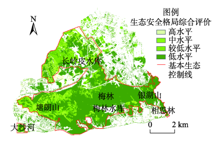
Fig. 13 The evaluation of ecological security pattern by objective method in 2013图13 2013年客观分析法生态安全格局评价 |
Tab. 6 The evaluation of ecological security pattern by subjective method in 2008 and 2013表6 2008年和2013年生态安全格局主观分析法评价表 |
| 等级 | 状态 | 面积/km2 | 面积百分比/% | ||
|---|---|---|---|---|---|
| 2008 | 2013 | 2008 | 2013 | ||
| 1 | 高水平 | 50.03 | 49.90 | 60.76 | 60.60 |
| 2 | 中等水平 | 48.46 | 48.58 | 58.85 | 58.99 |
| 3 | 较低水平 | 42.54 | 42.57 | 51.66 | 51.70 |
| 4 | 低水平 | 35.26 | 35.30 | 42.82 | 42.87 |
Tab. 7 The evaluation of ecological security pattern by objective method in 2008 and 2013表7 2008年和2013年生态安全格局客观分析法评价表 |
| 等级 | 状态 | 面积/km2 | 面积百分比/% | ||
|---|---|---|---|---|---|
| 2008 | 2013 | 2008 | 2013 | ||
| 1 | 高水平 | 49.90 | 49.90 | 60.60 | 60.60 |
| 2 | 中等水平 | 48.46 | 48.58 | 58.85 | 58.99 |
| 3 | 较低水平 | 35.30 | 35.30 | 42.87 | 42.87 |
| 4 | 低水平 | 25.82 | 26.15 | 31.36 | 31.75 |
The authors have declared that no competing interests exist.
| [1] |
|
| [2] |
[
|
| [3] |
[
|
| [4] |
[
|
| [5] |
[
|
| [6] |
[
|
| [7] |
[
|
| [8] |
[
|
| [9] |
[
|
| [10] |
[
|
| [11] |
[
|
| [12] |
[
|
| [13] |
[
|
| [14] |
[
|
| [15] |
[
|
| [16] |
[
|
| [17] |
[
|
| [18] |
[
|
| [19] |
[
|
| [20] |
[
|
| [21] |
[
|
| [22] |
[
|
| [23] |
[
|
| [24] |
[
|
| [25] |
[
|
| [26] |
[
|
| [27] |
[
|
| [28] |
[
|
| [29] |
[
|
| [30] |
[
|
| [31] |
[
|
| [32] |
[
|
| [33] |
《中国生物多样性国情研究报告》编写组.中国生物多样性国情研究报告[M].北京:中国环境科学出版社,1998:1-430.
[ The preparation group of "China biodiversity national situation research report". China biodiversity national situation research report[M]. Beijing: China Environmental Science Press, 1998:1-430. ]
|
| [34] |
[
|
| [35] |
[
|
/
| 〈 |
|
〉 |