遥感科学与应用技术

不同城市规划的生态质量差异对比研究

  • 方灿莹 , 1, 3 ,
  • 胡秀娟 , 1, * ,
  • 徐涵秋 1, 2, 3 ,
  • 王美雅 1, 3 ,
  • 林中立 1
展开
  • 1. 福州大学遥感信息工程研究所,福州 350116
  • 2. 空间数据挖掘与信息共享教育部重点实验室,福州 350116
  • 3. 福州大学环境与资源学院,福州 350116
*通讯作者:胡秀娟(1980-),女,福建福州人,博士生,讲师,主要从事环境资源遥感应用研究。E-mail: huxiujuan@fzu.edu.cn

作者简介:方灿莹(1993-),女,福建漳州人,硕士,主要从事城市化及其环境影响评价研究。E-mail:

收稿日期: 2016-12-07

  要求修回日期: 2017-03-23

  网络出版日期: 2017-08-20

基金资助

国家自然科学基金项目(41501469)

Comparison of the Ecological Quality between Different Urban Plannings

  • FANG Canying , 1, 3 ,
  • HU Xiujuan , 1, * ,
  • XU Hanqiu 1, 2, 3 ,
  • WANG Meiya 1, 3 ,
  • LIN Zhongli 1
Expand
  • 1. Institute of Remote Sensing Information Engineering, Fuzhou University, Fuzhou 350116, China
  • 2. Key Laboratory of Spatial Data Mining & Information Sharing of Ministry of Education, Fuzhou University, Fuzhou 350116, China
  • 3. College of Environment and Resources, Fuzhou University, Fuzhou 350116, China
*Corresponding author: HU Xiujuan, E-mail:

Received date: 2016-12-07

  Request revised date: 2017-03-23

  Online published: 2017-08-20

Copyright

《地球信息科学学报》编辑部 所有

摘要

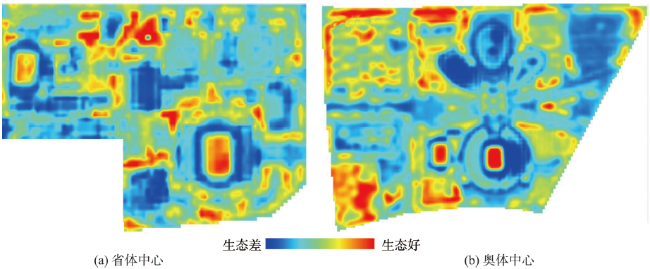
为定量分析不同城市规划理念带来的生态质量差异,本文以福州市在不同时期规划建设的2座体育场馆为例,基于Sentinel-2A遥感影像,应用新型遥感生态指数RSEI分析对比了这2座体育场馆的生态效应。在全面分析其主要地表覆盖信息的基础上,探讨了二者之间生态质量差异的原因。研究发现,采用传统理念规划的福建省奥林匹克体育中心的生态指数RSEI均值为0.39,而实行绿色生态规划的海峡奥林匹克体育中心的RSEI均值为0.42,优于福建省奥林匹克体育中心。总的看来,海峡奥体中心在规划中采用透水铺装和不勾缝的铺装形式,加大绿地斑块面积以及预留风道等绿色措施有效地提高了地表湿度、降低了地表温度和干度,从而对该体育中心的生态质量起到积极的作用。

本文引用格式

方灿莹 , 胡秀娟 , 徐涵秋 , 王美雅 , 林中立 . 不同城市规划的生态质量差异对比研究[J]. 地球信息科学学报, 2017 , 19(8) : 1097 -1107 . DOI: 10.3724/SP.J.1047.2017.01097

Abstract

The rapid urbanization has brought about the benefit to the human society. Nevertheless, it also leads to a series of ecological problems, such as urban heat island and urban waterlogging. According to the blueprint and guidance for urban development, urban planning has a profound implication on the urban ecological quality in various ways. Therefore, a timely and precisely monitoring and assessment of ecological responses to different urban planning techniques have become an important issue for regional decision-makers. To meet this requirement, taking two sports centers that were built in 1980s and 2010s, respectively, in Fuzhou city as cases, this study utilized a recently developed Remote Sensing Ecological Index (RSEI) to assess the ecological responses of the two sports centers to their different planning manners. A Sentinel-2A image dated on June 23, 2016 was employed to compute the RSEI of two sports centers. Furthermore, three thematic indices, Normalized Difference Impervious Surface Index (NDISI), Normalized Difference Vegetation Index (NDVI) and Modified Normalized Difference Water Index (MNDWI), were utilized to extract the thematic features of impervious surface, vegetation and open water, respectively, from the used satellite images. The overall accuracies of the thematic feature extraction were greater than 90.0%. In addition, the Red Edge Position (REP) was calculated to estimate the state of vegetation growth. Based on the analysis of the main land cover information, the reasons for the differences of ecological quality between the two sports centers were then carried out. Results showed that the RSEI value of the Fujian Olympic Sports Center, built in 1980s with traditional planning manner, was 0.39, while the Fuzhou Strait Olympic Sports Center, recently-built with green ecological planning thought, had a higher value of 0.42, indicating a higher ecological quality of the Fuzhou Strait Olympic Sports Center. This owes mainly to the green ecological planning for the sports center. The green construction techniques used in the planning of the Fuzhou Strait Olympic Sports Center include the use of pervious surface, pavement without pointing joint, increase in green patches area, and reservation of wind corridors. These have effectively improved the ground wetness, reduced the land surface temperature and dryness, and thus have a great contribution to the ecological quality of the center. In addition, due to the immature status of the green plants in the Fuzhou Strait Olympic Sports Center, the vegetation growth in this center was slightly worse than that of the Fujian Olympic Sports Center, suggested by a relatively low mean NDVI value (0.522) of the center, compared with 0.562 of the Fujian Olympic Sports Center. Nevertheless, it is predictable that the NDVI of the Fuzhou Strait Olympic Sports Center could be higher than that of the Fujian Olympic Sports Center after a period of plant growth, and the ecological quality of the center would be further enhanced. On the whole, this study revealed that the adverse impact on ecological quality brought by urban construction could be effectively reduced by the green urban planning technology. Hence, it is essential to formulate and implement the green eco-environment conservation measures during the urban planning and construction so as to prevent further deterioration of the ecological environment.

1 引言

快速城市化在给人类社会带来繁荣和进步的同时也导致了一系列严重的生态问题,如普遍存在的热岛效应和日益突出的城市内涝,这一切都与城市规划的理念密切相关[1-3]。为使城市向低碳、绿色、生态转型,2013-2015年国家住建部相继颁发了《“十二五”绿色建筑和绿色生态城区发展规划》和《关于组织申报2015年海绵城市建设试点城市的通知》,全国各地规划部门也相继开展了绿色生态城区规划工作。绿色生态城区是指在空间布局、基础设施、建筑等方面根据绿色生态的理念及技术要求进行规划、建设、运营的新城区[4]。与传统规划的最大不同之处在于,它采用的是低影响开发模式,即在城市建设中引入生态理念从而最大限度地避免对自然生态的人为扰动。目前,中国正处于绿色生态城区建设的起步阶段,已经有一批示范工程相继建成,并投入使用,但这些基于绿色生态理念规划的新城区究竟是否达到规划设计的生态要求,还没有切实可行的评价方法,且对实施绿色生态规划后所带来的生态效应的相关研究也鲜有报道。
当前,以遥感和地理信息系统为代表的空间信息技术为区域生态质量的监测与评价提供了便捷有效的手段。从技术方法上看,区域生态评价已由仅依靠植被、地表温度等单一指标的评测逐步发展到多指标综合评价[5-10]。Nandy等[5]基于RS和GIS技术从土地利用/土地覆盖、森林冠层密度、森林火灾风险、滑坡敏感性和人口密度5个方面综合分析了喜马拉雅国家公园的生态环境脆弱性;Poulin等[6]以SPOT-5影像为数据源,结合实测数据和NDVI等指标对法国南部罗纳河三角洲的芦苇湿地生态系统进行评估;徐庆勇等[7]综合运用RS和GIS技术,从自然因素和人为因素2个方面选取了海拔高度、土地利用变化指数、景观多样性指数等14个指标构建了珠江三角洲生态质量评价模型;隋玉正等[8]基于上海城市气象、土地利用等数据,利用层次分析法建立了上海市的人居生态质量评价模型;潘竟虎等[9]基于多源遥感数据,从生态系统的生产力、稳定性、承载力3个方面选取多个指标,建立了生态质量遥感综合评价模型,定量地分析了疏勒河流域2001-2010年生态状况变化。但现有的生态监测评价以大、中尺度居多,以城市局部片区为单元的小尺度生态状况评价却鲜有开展,而且这些方法的评价指标大多带有区域特性,难以获取,因此也难以推广使用。另外,现有的评价结果往往以一个数值来代表整个地区的生态状况,由于过于笼统且缺乏可视性,使区内生态质量的空间分异无法得以进一步了解。鉴于此,徐涵秋提出了一个完全基于遥感信息的遥感生态指数(Remote Sensing Ecological Index,RSEI)[11-12]。由于该指数的各指标完全基于遥感信息,容易获得,且结果能被可视化,因此,已得到广泛的应用[13-15]
福州市海峡奥林匹克体育中心建于2013年,是福州市生态城市建设的先行试点区,首次在规划建设中融入了绿色、低碳、生态的理念,2015年竣工后作为全国首届青运会主场馆正式投入使用。本文拟采用新型遥感生态指数RSEI,基于遥感信息技术对采用绿色生态规划的该体育中心以及早期以传统理念规划建设的福建省奥林匹克体育中心进行生态质量对比,以期客观评价绿色生态城区规划所产生的生态效应,为生态宜居城市的规划建设提供科学的决策依据。

2 研究区概况及数据源

2.1 研究区概况

福建省奥林匹克体育中心和福州市海峡奥林匹克体育中心是福建省福州市的2个大型城市体育服务综合体(以下简称省体中心和奥体中心),区内建筑主要以大型体育场馆及相应的体育配套设施为主(图1)。其中省体中心始建于1986年,它座落于福州市鼓楼区五四路与北环路交界处(26°06′45′′~26°07′02′′N,119°17′36′′~119°18′02′′E),占地41.3 hm2。奥体中心是2013年为迎接首届全国青年运动会建设的大型体育场馆,位于福州市南台岛仓山组团中部(26°01′02′′~26°01′36′′ N,119°16′22′′~119°17′13′′E),占地132 hm2。2座体育中心的东西向距离约为2 km,南北间距不到10 km,周边大部分为居住和商业用地,用地性质基本相同,建筑物的用途、结构等也差异不大。因此, 2座体育中心的气候,地形等自然地理条件以及周围环境基本一致。
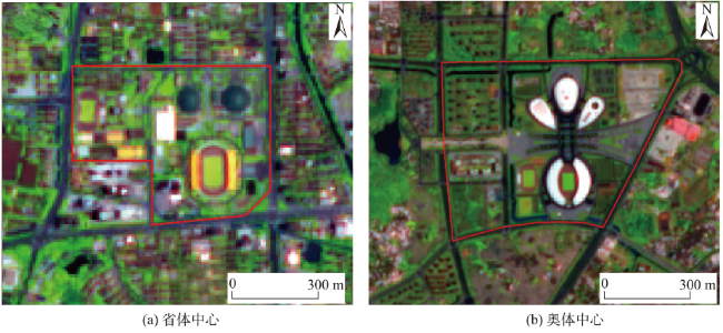
Fig. 1 Sentinel-2A images of Fujian Olympic Sports Center and Fuzhou Strait Olympic Sports Center (Red frame indicates the boundary of the sports centers)

图1 福建省省体中心和奥体中心遥感影像(红色实线代表体育场馆边界)

2.2 数据源及影像预处理

本研究采用Sentinel-2A作为遥感数据源。Sentinel-2A是欧洲“哥白尼”计划中的Sentinels系列卫星之一,由欧盟委员会(European Commission, EC)和欧洲太空局(European Space Agency, ESA)共同实施,于2015年6月23日从法国圭亚那库鲁航天中心发射成功,2015年12月3日起,数据正式向全球用户免费开放[16]。该卫星所搭载的多光谱成像仪(MSI)共设有13个不同空间分辨率的光谱波段。与同为10 m空间分辨率的SPOT 5相比,其4个10 m 分辨率波段可使Sentinel-2A卫星数据与SPOT-5的影像数据保持良好的连续性;2个20 m分辨率的短波红外波段明显优于仅有1个短波红外波段的SPOT-5影像;3个20 m分辨率的红边波段可提供更多有关植被生长状态的重要信息,3个60 m分辨率的波段则可用于大气校正和卷云辨识(表1)。另外,它所具有的12 bit辐射分辨率,10 d重访周期,290 km幅宽及免费下载等优点,使其综合性能远超昂贵的SPOT-5影像。Sentinel-2A可应用于土地利用/覆盖状况和变化、生态环境监测、水资源管理、农业估产等领域[16]。目前,已在国外土地覆盖分类、植被健康监测等方面得到了成功的应用,但在区域生态质量监测与评价方面的研究还相对缺乏。而在国内,Sentinel-2A影像尚无应用研究的报道,因此本文尝试将Sentinel-2A应用于生态质量评价,以考察该影像的应用潜力。
Tab. 1 Comparison of multi-spectral bands of Sentinel-2A with SPOT 5

表1 Sentinel-2A与SPOT 5影像多光谱波段的主要参数对比

Sentinel-2A SPOT-5
波段号 波段 波长/um 空间分辨率/m 辐射分辨率/bit 波段号 波段 波长/um 空间分辨率/m 辐射分辨率/bit
1 Coastal 0.430~0.457 60 12
2 Blue 0.440~0.538 10 12
3 Green 0.537~0.582 10 12 1 Green 0.50~0.59 10 8
4 Red 0.646~0.684 10 12 2 Red 0.61~0.68 10 8
5 Red edge 0.694~0.713 20 12
6 0.731~0.749 20 12
7 0.769~0.797 20 12
8 NIR-1 0.760~0.908 10 12 3 NIR 0.78~0.89 10 8
8b NIR-2 0.848~0.881 20 12
9 Water vapor 0.932~0.958 60 12
12
12
10 Cirrus 1.337~1.412 60 12
11 MIR-1 1.539~1.682 20 12 4 MIR 1.58~1.75 20 8
12 MIR-2 2.078~2.320 20 12
本文采用的Sentinel-2A遥感影像下载于欧空局Sentinel科学数据中心(https://scihub.copernicus.eu),产品等级为1C级,成像时间为2016年6月23日, 同时用到的还有6月25日的Landsat 8影像。2幅影像虽然相差2 d,但气象条件一致(表2),可以互补使用。
Tab. 2 Weather Data (from China Meteorological Data Sharing Service System)

表2 福州乌山天气数据(来源:中国气象数据网)

日期 时间/h 气压/hpa 海平面气压/hpa 气温/℃ 相对湿度/% 降水量/mm
2016-06-23 11 998.2 1007.8 33.7 61 0
2016-06-24 11 997.5 1007.1 33.6 61 0
2016-06-25 11 998.4 1007.9 34.0 58 0
在影像预处理上,根据Sentinel-2A官方技术手册和相关的数据说明,1C级产品已经做过几何精校正,并通过辐射校正将影像的亮度值(DN)转为大气顶部反射率(TOA)。但为了方便数据分发,该产品将各波段的TOA乘以一个固定系数,并以16 bit整型保存。该系数的默认值为10 000 (可从头文件的QUANTIFICATTION_Value语句中查得)。因此,用户获得1C级产品后只需将各波段的DN值除以10 000,即可还原为大气顶部反射率[17-19],相应的计算公式如式(1)所示。
ρ λ = Q cal / 10000 (1)
式中:ρλ为λ波段经过大气校正的反射率;Qcal为影像以16位量化的DN值。

3 研究方法

由于建筑区生态环境涉及到的地物主要有不透水面、绿地和水体,因此,本文采用与这些地物对应的遥感专题指数来提取这些主要的地表参数信息,同时还采用了Sentinel-2A新增的红边波段来估算植被的生长状态。在此基础上,通过遥感生态指数RSEI来定量分析省体中心与奥体中心的生态质量,评价不同的规划设计所产生的生态效应。

3.1 植被信息获取

本文选用应用最广泛的归一化植被指数(NDVI)来获取植被信息,其公式为:
NDVI = NIR - R NIR + R (2)
式中:NIR为近红外波段的反射率;R红光波段的反射率。

3.2 水体信息提取

水体信息提取采用的是改进的归一化差值水体指数(MNDWI)[20],公式为:
MNDWI = ( Green - MIR ) ( Green + MIR ) (3)
式中:GreenMIR分别代表绿光和中红外第1波段的反射率。

3.3 不透水面信息获取

本文采用归一化差值不透水面指数(NDISI) [21]提取不透水面。该指数可以有效地区分土壤和不透水面,且无需预先剔除水体[22-23]。公式为:
NDISI = LST - ( MNDWI + NIR + MIR ) 3 LST + ( MNDWI + NIR + MIR ) 3 (4)
式中:LST为地表温度;MNDWI为改进的归一化差值水体指数;NIRMIR分别为近红外、中红外1波段的反射率。

3.4 植被红边位置计算

红边位置(REP)是指在红光和近红外范围内植被反射光谱曲线斜率最大的位置。红边位置与植物叶片的叶绿素含量息息相关,当植被生长较为旺盛,叶绿素含量增加时,红边位置会向长波方向移动,即红移,反之则向短波方向移动,因此,红边位置是衡量植被生理状态的重要指标[24-26]。常用的红边提取算法包括拉格朗日法、线性外推法、倒高斯模型法和线性四点内插法,其中Guyot和Baret提出的线性四点内插法只需4个波段的反射率就可求出红边位置[27],运算简单,模型拟合度好[28-29],因此本文采用该方法计算植被的红边位置。Sentinel-2A遥感影像对应的内插公式为:
REP = 705 + 35 0.5 ( ρ 665 + ρ 783 ) - ρ 705 ρ 740 - ρ 705 (5)
式中:ρ665、ρ705、ρ740、ρ783分别代表Sentinel-2A第4-7波段的反射率。

3.5 遥感生态指数RSEI计算

遥感生态指数RSEI选用了绿度、湿度、热度、干度4大生态要素来综合反映区域生态状况,并通过主成分变换来集成各指标,在克服指标单一缺点的同时,使各分指标的集成更客观合理。由于该指数完全基于遥感信息,可根据影像的分辨率用于不同尺度的生态质量研究,有效地弥补了国家环境保护部推出的生态环境状况指数(EI)只能用于县级以上区域生态质量评价的不足[11-12]。另外,RSEI指数的结果可以可视化,可被用于生态质量时空变化分析、模拟和预测。因此,提出以来已被广泛应用[13-15]
RSEI指数各指标可通过以下遥感指数或参量求取。
(1)绿度:以归一化植被指数NDVI(公式2)表征RSEI中的绿度指标。
(2)湿度:通常用缨帽变换中的湿度分量来代表。但目前尚无专门针对Sentinel-2A提出的缨帽变换湿度算法。由于Sentinel-2A的波段设置及对应波长范围与Landsat 8相似,因此本文先借助Landsat 8的缨帽变换湿度算法反演出Sentinel-2A的初始湿度影像,然后将其与近同期的Landsat 8影像(成像时间为2016年6月25日,与Sentinel-2A仅相差2 d)反演出的湿度影像进行回归分析,二者的相关系数可达0.761,表明它们具有较强的线性关系。在此基础上,利用二者的回归方程系数再对Sentinel-2A的初始湿度影像进行校正,得到最终的湿度影像。其中,Landsat 8影像的湿度反演公式为[30]
Wet = 0 . 1511 ρ 2 + 0 . 1973 ρ 3 + 0 . 3283 ρ 4 + 0 . 3407 ρ 5 - 0 . 7117 ρ 6 - 0 . 4559 ρ 7 (6)
式中:ρ2、ρ3、ρ4、ρ5、ρ6和ρ7分别为Landsat 8第2-7波段的反射率。
Landsat 8与Sentinel-2A的回归方程为:
We t L 8 = 0.5905 We t S - 2 A 0.0051 (7)
式中:WetL8代表Landsat 8影像反演出的湿度;WetS-2A代表Sentinel-2A的初始湿度。
(3)干度:由合成的建筑指数IBI[31]和裸土指数SI[32]来代表干度指标(NDSI),相应的计算公式为:
NDSI = SI + IBI 2 (8)
其中: SI = ( ρ 11 + ρ 4 ) - ( ρ 8 + ρ 2 ) ( ρ 11 + ρ 4 ) + ( ρ 8 + ρ 2 ) (9)
IBI = 2 ρ 11 / ( ρ 11 + ρ 8 ) - [ ρ 8 / ( ρ 8 + ρ 4 ) + ρ 3 / ( ρ 3 + ρ 11 ) ] 2 ρ 11 / ( ρ 11 + ρ 8 ) + [ ρ 8 / ( ρ 8 + ρ ) + ρ 3 / ( ρ 3 + ρ 11 ) ] 4 (10)
式中:ρ2、ρ3、ρ4、ρ8和ρ11分别为Sentinel-2A第2、3、4、8、11波段的反射率。
(4)热度:用地表温度(LST)代表热度指标,因Sentinel-2A影像不具备热红外波段,因此选用以上日期仅差2 d的Landsat 8 影像的TIRS 10热红外波段来代替,并采用Nichol的方法[33]将地表温度影像细化至10 m,以便与Sentinel-2A 10 m空间分辨率相匹配,提高地表热环境的辨析度。地表温度反演采用的是Jiménez-Muñoz等针对Landsat 8提出的单通道算法[34],基本表达式如下:
L λ = M L × Q λ + A L (11)
LST = γ [ ε - 1 ( ψ 1 L λ + ψ 2 ) + ψ 3 ] + δ (12)
式中:Lλ为TIRS 10波段在传感器处的辐射值;MLAL为波段的调整因子和调整参数,可从头文件获取;γ和δ是基于Planck函数的2个参数;ε为地表比辐射率;ψ1、ψ2、ψ3是大气水汽含量w的函数,相关参数的计算方法和取值详见文献[34]。
由于4个指标量纲不统一,需对它们进行正规化,使各指标数值范围统一到0~1之间后再进行主成分分析。正规化公式为:
N I i = I i - I min I max - I min (13)
式中:NIi为正规化后的某一指标值;Ii为该指标在像元i的值;IminImax分别为该指标的最小、最大值。
对正规化后的4个指标进行主成分分析,得到PC1,为使数值大小与生态质量优劣相对应,进一步用1减去PC1获得初始生态指数RSEI0
RSE I 0 = 1 - { PC 1 [ f ( Wet , NDVI , LST , NDSI ) ] } (14)
为了便于指标度量和比较,同样可对RSEI0进行正规化:
RSEI = RSE I 0 - RSE I 0 _ min RSE I 0 _ max - RSE I 0 _ min (15)
RSEI即为遥感生态指数,其值介于0到1之间,RSEI值越接近1,表示生态质量越好,反之则说明生态越差。本文先计算出整张影像的遥感生态指数,然后从中分别裁剪出省体中心和奥体中心的RSEI影像,以作对比。

4 结果与分析

4.1 省体中心和奥体中心主要的地表覆盖信息

将上节公式应用于该影像,反演出省体中心和奥体中心的主要地表覆盖信息(表3),并采用近同期的Google Earth高分辨率遥感影像对提取结果进行人机交互验证。验证结果表明,省体中心和奥体中心主要地表覆盖信息提取总精度分别为90.5%和92.5%,Kappa系数为0.83和0.88。其中,省体中心植被,不透水面和水体的生产者精度分别为90.59%、90.1%和92.86%,使用者精度为89.53%、91%和92.86%;奥体中心植被、不透水面,水体的生产者精度为92.13%、93.1%、91.67%,使用者精度则分别为95.35%、92.05%和91.67%,提取的总精度及各类用地的使用者和生产者精度都在85%以上,符合分类精度要求。
表3可看出,省体中心的不透水面覆盖面积比例达69%,比奥体中心高出了6.3个百分点。从植被和水体所占的面积比例来看,省体中心略低于奥体中心。另外,省体中心绿地斑块的平均面积也明显小于奥体中心。总的看来,采用绿色生态技术设计的奥体中心的不透水面比例有了明显的下降,植被和水体覆盖率有了一定的增加。
Tab. 3 The main land cover types of Fujian Olympic Sports Center and Fuzhou Strait Olympic Sports Center

表3 福建省省体中心和奥体中心的主要地表覆盖信息

省体中心 奥体中心
面积/hm2 百分比/% 面积/hm2 百分比/%
不透水面 28.54 69.09 82.82 62.75
植被 12.62 30.55 42.62 32.29
水体 0.15 0.36 3.15 2.39
绿地斑块平均
面积/hm2
0.18 0.29

4.2 省体中心与奥体中心生态质量对比

图2是省体中心和奥体中心的遥感生态指数RSEI影像,表4是4个分指标和RSEI的均值。从表4可看出,2016年省体中心的RSEI均值为0.39,而奥体中心为0.42,比省体中心的0.39提高了7.69%,这表明经过绿色生态规划的奥体中心的生态质量总体好于省体中心。从4个分指标对PC1的载荷来看(表4),绿度和湿度的载荷值均为正值,表明它们对生态起正面作用,而干度和热度为负值,说明它们对生态起负面作用。就各分指标而言,奥体中心的绿度不及省体中心,但湿度高出省体中心23.8%,热度和干度则低于省体中心。虽然奥体中心绿度低于省体中心,但其他3个分指标均优于省体中心,且湿度、热度、干度的载荷值之和远大于绿度,说明三者的贡献度大于绿度,湿度的升高以及干度和热度的下降所产生的综合生态效应足以抵消绿度的影响。因此,综合4个分指标的遥感生态指数RSEI客观揭示了奥体中心的生态质量总体好于省体 中心。
为了更好地研究省体中心和奥体中心的生态状况差异,进一步利用密度分割技术将RSEI影像划分为差、中、优3个生态等级[2],并统计出各生态等级的面积(表5)。结果表明,省体中心生态等级为优所占的面积比例为4.14%,而等级为差所占的面积比例为35.44%;相比之下,奥体中心生态级别为优所占的面积比例为8.29%,约为省体中心的2倍,生态等级为差的面积比例则为28.19%,低于省体中心7个百分点,总体反映出奥体中心的生态质量优于省体中心。
从空间分布上看,省体中心和奥体中心内植被覆盖率较高区域的生态等级基本都在中等以上;而生态质量差的地区主要集中于不透水面分布区,如体育场馆、室外运动场地、道路等硬质地面(图1-2)。
Fig. 2 RSEI images of the two sports centers

图2 省体中心与奥体中心遥感生态指数RSEI影像

Tab. 4 Statistics of four indicators and RSEI of the two sports centers

表4 福建省省体中心和奥体中心4个指标和遥感生态指数RSEI的统计值

类别 区域 湿度(Wet) 绿度(NDVI) 干度(NDSI) 热度(LST) 遥感生态指数(RSEI)
均值 省体中心 0.362 0.562 0.578 0.580 0.390
奥体中心 0.448 0.522 0.545 0.521 0.420
PC1载荷值 省体中心奥体中心 0.312 0.646 -0.434 -0.545

注:由于本研究基于整幅影像计算遥感生态指数RSEI,因此奥体中心和省体中心的PC1载荷值一致

4.3 省体中心与奥体中心生态质量差异的原因分析

由上述分析可知,奥体中心的生态质量优于省体中心,这主要得益于以下4个方面。
(1)不透水面比例的降低
不透水面是造成地表干化、生态退化的主要因子。奥体中心不透水面比例明显低于省体中心,相应的地表干度下降,从而对生态质量产生正面影响,表4中二者的干度指标相差了5.71%。已有研究表明不透水面有强烈的升温作用[35]。本次研究将不透水面指数NDISI归一化到0~1之间,并转换成百分率,然后将其与温度的关系进行定量回归分析[36-37]。结果发现,不透水面与地表温度呈指数函数关系,高不透水面覆盖的地区会加剧地表温度的上升。从图3散点图和回归方程来看,不透水面的升温幅度并不恒定,不透水面比例每增加10%,地表温度会相应升高1.66~2.84 °C,在高不透水面覆盖区的升温幅度要比低覆盖区高出1°C,特别当 不透水面比例大于60%时,地表温度会快速上升 (图3)。
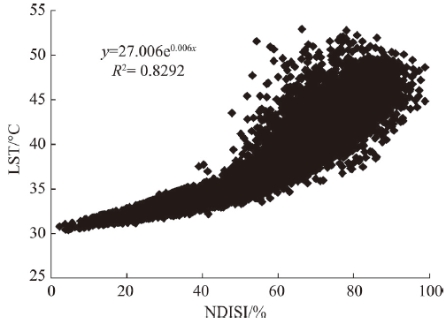
Fig. 3 Regression analysis of impervious surface and LST
分析省体和奥体中心的不透水面比例可以看出,奥体中心不透水面比例为62.75%,略大于60%这一快速升温临界值(图3),而省体中心的不透水面比例达69%,所以其有近10%的不透水面处于快速升温的比例段。由于不透水面会阻止水的下渗,阻断自然地表的蒸散作用,导致自然调节地面温度和湿度的能力显著降低。再加上这些人工不透水面往往比土壤、植被具有更大的热容量和吸收率,热辐射能力强,在大量吸收、储存太阳辐射能之后又将其释放出来,造成了地表温度的上升。因此,奥体中心相对低的不透水面比例对其热环境的改善和生态质量的提升起积极作用。
Tab. 5 Area and percent of the RSEI-based ecological grades

表5 生态级别面积和比例

生态等级 省体中心 奥体中心
面积/hm2 百分比/% 面积/hm2 百分比/%
14.64 35.44 37.21 28.19
24.96 60.42 83.83 63.52
1.71 4.14 10.94 8.29
(2)透水铺装材料的使用
根据《福州海峡奥体绿色生态城区专项规划》[38],奥体中心在规划设计上采用了低影响开发模式。区内大片开阔的广场虽然延用了石板材等不透水铺装,但采用了不勾缝的铺装形式,人行道和室外停车场普遍采用透水砖和植草砖来替代传统的水泥不透水路面;而省体中心的道路、广场、停车场等都采用传统的水泥铺装(图4)。根据样区统计结果,奥体中心不勾缝铺装和采用植草砖的停车场的RSEI均值分别为0.316和0.473,而省体中心传统硬质水泥路面和停车场的RSEI均值为0.308,说明透水铺装材料的使用对生态质量的改善起着积极的作用。这些透水铺装由于自身具有与外部空气及下部透水垫层相连通的多孔构造,大大提高了地表的透水性,使降水可渗入其下土层,增加了地表下垫层土壤的湿度。当天气晴朗时,下垫层土壤中丰富的毛细水,通过自然蒸发和太阳辐射作用下的蒸散作用,吸收大量的热量,从而起到了增加路面和周围空间湿度、降低地表温度的作用。反观以传统水泥铺装为主的省体中心,其地表湿度低,蒸发量少,地面趋于干化。这也是奥体中心的不透水面比例仅比省体中心低不到7个百分点,但湿度却高出省体中心23.8%的重要原因之一。
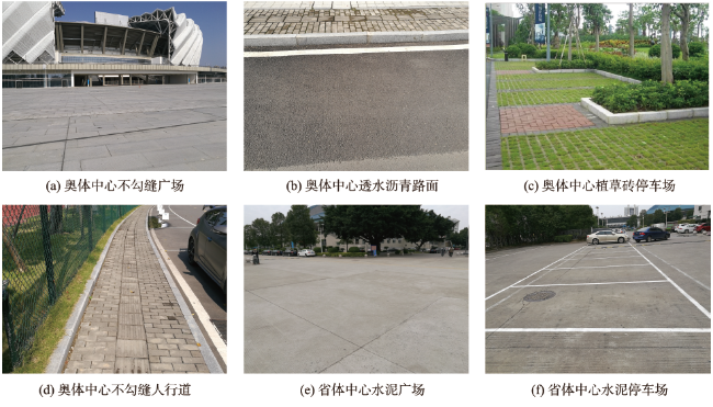
Fig. 4 Ground pavement of the two sports centers

图4 福建省省体中心和奥体中心的地面铺装

(3)通风廊道的设计
风道预留设计也是降低奥体中心地表温度的重要因素。由海峡奥体绿色生态城区风道示意 图[38]可知(图5),该设计依托街道、绿带等开敞空间,在奥体中心预留了2条一级风道和4条二级风道。福州市夏季盛行东南风,该设计的1条一级风道几乎平行风向,因此有利于将夏季风引入该区。而中部设计的一条东西向约150 m宽的景观大道(图1),可使沿风道进来的夏季风通过景观大道向两侧渗透,有效提高了内部空气的流通性,带走多余的热量。结合图1和实地考察发现,奥体片区建筑密度低,间距大,各建筑物朝向一致,预留通风廊道的两侧几乎都是开敞的公共绿地或者广场,无高层建筑阻挡,因此风的贯通性很好。而省体中心内建筑密度高、间距小,楼层高低错落,没有明显的风道,因此会有大量的热量积聚在街道内,造成地表温度升高。
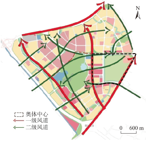
Fig. 5 Wind corridors in the Fuzhou Strait Olympic area (from the Institute of Fuzhou Urban Planning & Research)

图5 福州海峡奥体绿色生态城区风道示意图(据福州市规划设计研究院)

(4)绿地斑块面积的增大
研究已表明,绿地面积与绿地的增湿降温效应呈显著正相关关系,即绿地斑块面积越大,增湿降温效应越明显[39-40]。奥体中心与省体中心的绿地率虽差异不大,但奥体中心绿地斑块的平均面积为0.29 hm2,明显大于省体中心的0.18 hm2表3)。从图1可看出,奥体中心的绿地分布较集中,块状绿地居多,特别是体育场馆两侧多为集中成片的开放式绿地;而省体中心绿地则较为破碎,多以点状或条带状分散分布。因此,奥体中心内绿地总体的增湿降温作用会强于省体中心,进而更有效地改善周边环境小气候,对生态质量起积极作用。
值得一提的是,奥体中心的植被面积比例高于省体中心(表3),但在表征植被绿度的NDVI指数值方面却逊于省体中心。为了解释这一现象,从省体、奥体中心的影像中各选取了113个纯净的植被像元作为样本(包括42个草地、71个树木样本),通过公式(5)分别计算它们的红边位置。结果表明,与省体中心相比,奥体中心无论是草坪还是树木,其红边位置都更靠近短波方向(表6),说明奥体中心植被的总体叶绿素含量低于省体中心,导致其在近红外和红光波段处的反射率反差小于省体中心,造成了NDVI值的降低。这主要是因为奥体中心2015年才陆续竣工,区内绿化植物多为新种植或者移栽的,多数处于幼龄阶段,植被冠幅小,叶绿素含量低。而省体中心内的绿化植物已经过了近30年的生长,枝繁叶茂,因此奥体中心的植被覆盖面积虽稍高于省体中心,但其NDVI值仍不及省体中心。但可以预见,奥体中心的绿化植物再经过一定的生长时间,其NDVI值有可能会反超省体中心,使奥体中心的生态质量进一步优于省体中心。
综上,绿色生态城区规划可有效地降低城市建设对生态的负面影响。因此,在今后城市规划与建设中应采用低影响开发模式,减少不透水面覆盖面积,增加规模绿地和水体面积;尽量使用透水铺装来替代传统的大片水泥硬质地面;严格控制建筑密度和高度,注重道路的贯通性,保留好通风廊道。
Tab. 6 The red edge position of vegetations in the two sports centers (nm)

表6 福建省省体中心和奥体中心植被红边位置(nm)

类别 省体中心 奥体中心
草地 树木 草地 树木
均值 724.00 723.96 722.78 722.42

5 结论

本文基于Sentinel-2A影像,综合采用多种遥感指数,对比了传统规划设计的省体中心和采用绿色生态技术设计的奥体中心的生态质量差异,得到如下结论:
(1)采用绿色生态技术设计的奥体中心的生态质量好于传统设计的省体中心,体现在奥体中心的生态指数RSEI均值为0.42,比省体中心的0.39提高了7.69%。
(2)奥体中心在规划设计上降低地表不透水面比例,采用透水铺装和不勾缝的铺装形式,以及预留风道、增大绿地斑块面积等多项绿色生态措施有效地提高了该区内的生态质量,使其生态质量优于省体中心。结果表明,绿色生态城区规划可以有效地降低城市建设对生态造成的不良影响。
(3)Sentinel-2A影像可以有效地应用于中小尺度的生态质量评价,它所具有的10 m空间分辨率可较Landsat系列影像更好地辨识地面地物特征。其2个中红外波段使它比其他同分辨率影像(SPOT)更好地用于土壤和建筑物分类,所具有的红边波段则有助于判别植被的生长状况,因此Sentinel-2A影像在生态领域中具有广阔的应用前景。

The authors have declared that no competing interests exist.

[1]
Feyisa G L, Meilby H, Jenerette G D, et al.Locally optimized separability enhancement indices for urban land cover mapping: Exploring thermal environmental consequences of rapid urbanization in Addis Ababa, Ethiopia[J]. Remote Sensing of Environment, 2016,175:14-31.Landsat data were used to assess urbanization-induced dynamics in Land use/cover (LULC), surface thermal intensity, and its relationships with urban biophysical composition. The study was undertaken in Addis Ababa city, Ethiopia. Ground-based data and high resolution images were used as reference data in LULC classification. To more accurately quantify landscape patterns and their changes, we applied new locally optimized separability enhancement indices and decision rules (SEI–DR approach) to address commonly observed classification accuracy problems in urban environments. We tested the SEI–DR approach using eight Landsat images acquired between 1985 and 2010. Two approaches were applied to quantify surface heat intensity (SHIn) and to examine its spatial patterns over 2502years: thermal gradient analysis and hot spot analysis. A Simultaneous Autoregressive Spatial error model (SARerr) was used to explore relationships between surface temperature and biophysical variables describing urban surfaces. Compared to Maximum Likelihood (ML) and Support Vector Machine (SVM) classification, accuracy improvement achieved through use of the SEI–DR procedure was, respectively, 6% and 5% and the differences were statistically significant ( P 02<020.05). The Surface Heat Intensity (SHIn) analysis showed increasing contrast (1985-2010) between urban centers and the outskirt. On average, outskirts were cooler than central urban areas by up to 3.702°C. We detected statistically significant differences in intra-urban thermal aggregation ( P 02<020.01) and the differences ranged from 4.402°C to 5.302°C. Increasing heat intensity was observed between 1985 and 2010. However, we observed no clear evidence of urban areas being warmer than rural. Built-up surfaces and bare soil showed similar positive relationships with surface temperature ( P 02<020.01), while vegetation showed a negative relationship ( P 02<020.05). We conclude that with rapid urbanization, thermal intensity increased but relationships with vegetation suggest that options for mitigating urban warming in tropical climates may be available. The development of a new urban classification method, use of hotspot analysis, and the investigations of the UHI for an African city fill important research gaps for studies of urban thermal variation.

DOI

[2]
何慧, 徐涵秋. 小区规划对其热环境影响的遥感分析[J].城市规划,2012,36(11):33-38.

[ He H, Xu H Q.Impact on thermal environment by district planning based on remote sensing technology[J]. City Planning Review, 2012,36(11):33-38. ]

[3]
Muthamilselvan A, Srimadhi K, Ramalingam N, et al.Urbanization and its related environmental problem in Srirangam Island, Tiruchirappalli district of Tamil Nadu, India-Thermal Remote Sensing and GIS approach[J]. Environmental Earth Sciences, 2016,75(9):1-13.Water conservation is critical under the current state of climate change and population growth; however, water-conservation programs and research in China have generally focused on technological rather than behavioral innovations. This paper focuses on the state of water-conservation behavior and water education in China to assess how education, particularly the 9-year compulsory education program, affects water-conservation behavior. A survey (237 participants) was conducted in Guangzhou, the third largest city in China, to determine the attitudes of citizens towards conserving water. Overall, the following observations were made: (1) although 9502% of the participants were aware of water conservation, only 4202% recognized that it is urgently needed; (2) water-conservation actions lag behind water-conservation awareness, and only 1902% of the participants were willing to perform more than five actions, including daily water reuse and conservation, whereas 4802% of the participants performed less than two actions; (3) additional education will result in improved water-conservation behavior; (4) more than half of the participants who had graduated from primary and secondary schools showed poor water-conservation behavior; and (5) water-conservation education in the 9-year compulsory education program was extremely rare (representing 0.2–1.402% of the curriculum) and only included in four compulsory courses. From these observations, it was concluded that water education seriously lags behind the economic development of Guangzhou. Water and environmental education should be emphasized in the 9-year compulsory education curriculum because this program has a relatively large number of students in China.

DOI

[4]
陈志端. 新型城镇化背景下的绿色生态城市发展[J].城市发展研究,2015,22(2):1-6,19.当前,绿色生态发展已经成为我国新型城镇化战略的核心举措.随着绿色生态发展理念的不断深入和相关政策的相继出台,我国已经有越来越多的城市开展了绿色生态城市和城区的规划建设实践.在梳理各级政府激励政策的基础上,从实践类型、建设规模、开发模式和规划重点几方面对近年来绿色生态城区的发展概况进行了分析,并展望了绿色生态城市的发展趋势,提出相关对策和建议.

DOI

[ Chen Z D.Green eco-city development under the background of the new urbanization[J]. Urban Development Studies, 2015,22(2):1-6,19. ]

[5]
Nandy S, Singh C, Das K K, et al.Environmental vulnerability assessment of eco-development zone of Great Himalayan National Park, Himachal Pradesh, India[J]. Ecological Indicators, 2015,57:182-195.The Great Himalayan National Park (GHNP), located in western Himalaya, is a key mountainous ecosystem prone to environmental vulnerability because of anthropogenic stress and the natural disasters, viz., landslide and forest fire. We assessed the environmental vulnerability of the eco-development zone of GHNP using remote sensing (RS) and geographic information system (GIS) technologies. To quantify the environmental vulnerability, a numerical model using spatial principal component analysis (SPCA) was developed. This model considered five factors: land use/land cover, forest canopy density, forest fire risk, landslide susceptibility and human population density. The environmental vulnerability integrated index (EVSI) calculated for the 1990, 2000 and 2010 periods was found to be 2.00, 2.72, and 3.40, respectively. The results showed temporal increase in the environmental vulnerability in the zone. Based on the numerical outputs, the vulnerability of the region was categorized into five classes: potential, slight, medium, high, and severe. The primary factor responsible for the increase in vulnerability overtime was land use/land cover change in the study area due to hydro-electric power projects, construction of roads, and other infrastructure developments. Forest fire and decreased forest canopy density are other major contributing factors responsible for the increase in the environmental vulnerability. Our results indicated that integration of RS, GIS and SPCA can effectively quantify and assess environmental vulnerability.

DOI

[6]
Poulin B, Davranche A, Lefebvre G.Ecological assessment of Phragmites australis wetlands using multi-season SPOT-5 scenes[J]. Remote Sensing of Environment, 2010,114(7):1602-1609.Ecologists and conservationists need accurate and replicable tools for monitoring wetland conditions in order to develop and implement adaptive management strategies efficiently. The Rhone Delta (Camargue) in southern France encloses 9200ha of fragmented reed marshes actively managed for reed harvesting, waterfowl hunting or cattle grazing, and holding significant numbers of vulnerable European birds. We used multi-season SPOT-5 data in conjunction with ground survey to assess the predictive power of satellite imagery in modelling indicators of reed structure (height, diameter, density and cover of green/dry stems) relevant to ecosystem management and bird ecology. All indicators could be predicted accurately with a combination of bands (SWIR, NIR) and indices (SAVI, OSAVI, NDWI, DVI, DVW, MSI) issued from scenes of March, June, July, September or December and subtraction between these. All models were robust when validated with an independent set of satellite and field data. The high spatial resolution of SPOT-5 scenes (pixel of 10脳10m) permits the monitoring of detailed attributes characterizing the reed ecosystem across a large spatial extent, providing a scientifically-based, replicable tool for managers, stakeholders and decision-makers to follow wetland conditions in the short and long-term. Combined with models on the ecological requirements of vulnerable bird species, these tools can provide maps of potential species ranges at spatial extents that are relevant to ecosystem functioning and bird populations.

DOI

[7]
徐庆勇,黄玫,刘洪升,等.基于RS和GIS的珠江三角洲生态环境脆弱性综合评价[J].应用生态学报,2011,22(11):2987-2995.使用空间主成分分析法构建评价指标体系,采用层次分析法确定指标权重,结合遥感数据和地理信息系统软件,对珠江三角洲2004&mdash;2008年生态环境脆弱性进行了综合评价并对脆弱性成因进行分析.结果表明: 生态环境极度和重度脆弱区主要分布在珠江三角洲中部,占整个研究区面积的34.0%;生态环境中度脆弱区主要分布在珠江三角洲东部,占25.5%;生态环境轻度和微度脆弱区主要分布在珠江三角洲西部,分别占28.7%和11.8%. 中度和轻度脆弱区占整个研究区面积的54.2%,表明珠江三角洲大部分区域的生态环境属中度和轻度脆弱.影响珠江三角洲生态环境脆弱性的自然因素主要有海拔高度、大暴雨日数、水土流失比率、易涝耕地面积比率、归一化植被指数、景观多样性指数,人为因素主要有人口密度、单位面积废水排放量、单位面积废气排放量、土地利用变化、化肥施用强度、农药使用强度、万人机动车拥有量、环保投资指数. 极度和重度脆弱区的主要特征是海拔低、洪涝灾害发生频率高、易涝耕地面积多、植被破坏严重、污染强度大和环保投资指数小等.

[ Xu Q Y, Huang M, Liu H S, et al.Integrated assessment of eco-environmental vulnerability in Pearl River Delta based on RS and GIS[J]. Chinese Journal of Applied Ecology, 2011,22(11):2987-2995. ]

[8]
隋玉正,史军,崔林丽,等.上海城市人居生态质量综合评价研究[J].长江流域资源与环境, 2013,22(8):965-971 基于上海城市气象站点数据、卫星遥感反演的土地利用数据、气象灾情记录数据和植被叶面积指数数据,运用层次分析法结合专家咨询法,建立了上海城市人居生态质量评价指标体系,并综合应用遥感和地理信息系统(GIS)空间分析技术,从湿润指数、气象灾害指数、水体密度指数、植被覆盖指数和植被质量指数开展了上海城市250 m空间格网的人居生态质量评价和等级划分。结果表明:建立的评价指标体系对上海城市人居生态质量评价是可行的,上海人居生态质量在多数地区都为良或一般等级,在闵行、宝山和嘉定一些地区以及青浦和浦东个别地区人居生态质量为差,而在崇明北部和南部一些地区以及浦东、南汇和奉贤沿海极少地区人居生态质量为优等级

[ Sui Y Z, Shi J, Cui L L, et al. Integrated assessment of ecological quality for human settlements in Shanghai[J]. Resources and Environment in the Yangtze Basin, 2013,22(8):965-971. ]

[9]
潘竟虎,董磊磊. 2001-2010年疏勒河流域生态系统质量综合评价[J].应用生态学报,2016,27(9):2907-2915.疏勒河流域属于典型的干旱区内陆河流域,生态环境脆弱,对其进行生态系统质量评价意义重大.本文利用多源遥感数据,依据生态系统生产能力指数(EPI)/生态系统稳定性指数(ESI)/生态系统承载力指数(EBCI),建立遥感综合评价模型,对疏勒河流域2001&mdash;2010年的生态系统质量进行综合评价.结果表明: 疏勒河流域2001&mdash;2010年生态系统质量平均值为43.21,处于较低水平.EPI、ESI和EBCI的均值分别为47.16、58.09和28.52,说明疏勒河流域生态系统承载力较低.2001&mdash;2010年,EPI和EBCI分别增加了18.9%和20.1%,ESI下降了9.4%.流域生态系统质量总体呈现出先增加后下降的趋势,2001、2005和2010年生态系统质量年均值分别为 43.71、44.80和41.13.农田生态系统质量最高,水体生态系统质量最低.人工生态系统质量综合评价值为46.43,明显高于自然生态系统.

[ Pan J H, Dong L L.Comprehensive evaluation of ecosystem quality in the Shule River basin, Northwest China from 2001 to 2010[J]. Chinese Journal of Applied Ecology, 2016,27(9):2907-2915. ]

[10]
肖洋,欧阳志云,王莉雁,等.内蒙古生态系统质量空间特征及其驱动力[J].生态学报,2016,36(19):1-12.植被作为生态系统的重要组成部分,联结着大气、水分和土壤等自然过程,其变化将直接影响该区域气候水文和土壤等状况,是区域生态系统质量变化的重要指示器.植被状况的好坏,主要通过生物量和植被覆盖度因子来表示.内蒙古自治区是我国北方生态环境问题十分严重的省份,弄清当前区域生态系统质量状况与变化及其近10年来变化的驱动因素,对分析与制定区域生态环境保护决策具有十分重要的意义.基于2000-2010年生物量和植被覆盖度,并结合地区植被区划数据,对内蒙古植被生态系统质量状况进行分析,并评估其与气候(降水、温度),人类活动(交通密度、农业发展、生态恢复工程)的相关关系,在此基础上探讨了气候和人类活动对近年来内蒙古生态系统质量变化的影响.结果表明:(1)内蒙古生态系统质量状况整体偏低,其中森林生态系统平均质量最高,灌丛、草原生态系统次之.空间分布呈明显的经度地带性,由东向西,质量逐渐降低.2000-2010年内蒙古生态系统质量总体上呈现缓慢增长趋势,但局部地区生态系统质量仍存在恶化,其中在107°E以东的草原和森林区域,生态系统质量变化十分剧烈.(2)近10年来内蒙古生态系统质量的变化与气候和人类活动的关系非常密切,其与降水、GDP1、化肥施用量、天保工程和退耕还草工程呈现明显的正相关.而与温度、道路密度和京津风沙治理工程呈现明显的负相关.其中,生态保护工程实施区域内和区域外的相关性存在显著的差异性.随着内蒙古社会经济的快速发展,人类活动对生态系统质量的影响逐渐加强,但降水仍是该地区生态系统质量的主要影响因子.(3)在内蒙古生态系统质量变化典型区域内,质量的增长主要是由于降水的增加、温度的降低、农业的发展、退耕还草工程的作用和交通发展的放缓.质量的降低则是因为降水的减少、温度的增加、农业发展缓慢和交通发展的加快所致.

DOI

[ Xiao Y, OuYang Z Y, Wang L Y, et al. Spatial patterns of ecosystem quality in Inner Mongolia and its driving forces analysis[J]. Acta Ecologica Sinica , 2016,36(19):1-12. ]

[11]
徐涵秋. 城市遥感生态指数的创建及其应用[J].生态学报,2013,33(24):7853-7862.城市生态与人类生活息息相关,快速、准确、客观地了解城市生态状况已成为生态领域的一个研究重点。基于遥感技术,提出一个完全基于遥感技术,以自然因子为主的遥感生态指数(RSEI)来对城市的生态状况进行快速监测与评价。该指数利用主成分分析技术集成了植被指数、湿度分量、地表温度和建筑指数等4个评价指标,它们分别代表了绿度、湿度、热度和干度等4大生态要素。通过在福州主城区的应用表明,RSEI指数可以定量地评价和对比城市的生态质量,方便地进行时空动态变化分析。由于所选的指标完全基于遥感信息,容易获得,且计算过程无需人工干预,因此结果客观可靠、可比性强。

DOI

[ Xu H Q.A remote sensing urban ecological index and its application[J]. Acta Ecologica Sinica, 2013,33(24):7853-7862. ]

[12]
徐涵秋. 区域生态环境变化的遥感评价指数[J].中国环境科学,2013,33(5):889-897.基于遥感信息技术提出一个新型的遥感生态指数(RSEI),以快速监测与评价区域生态质量.该指数耦合了植被指数、湿度分量、地表温度和土壤指数等4个评价指标,分别代表了绿度、湿度、热度和干度等4大生态要素.与常用的多指标加权集成法不同的是,本研究提出用主成分变换来集成各个指标,各指标对RSEI的影响是根据其数据本身的性质来决定,而不是由人为的加权来决定.因此,指标的集成更为客观合理.将RSEI应用于福建长汀水土流失区,并与国家环境保护部《生态环境状况评价技术规范》中的生态指数EI的计算结果相比较,发现二者的结果具有可比性.不同的是,RSEI不仅可以作为一个量化指标,而且还可以对区域生态环境变化进行可视化、时空分析、建模和预测.因此,可弥补EI指数在这些方面的不足.

DOI

[ Xu H Q.A remote sensing index for assessment of regional ecological changes[J]. China Environmental Science, 2013,33(5):889-897. ]

[13]
温小乐, 林征峰, 唐菲. 新兴海岛型城市建设引发的生态变化的遥感分析——以福建平潭综合实验区为例[J].应用生态学报,2015,26(2):541-547.<div style="line-height: 150%">福建省平潭岛于2010年被正式确立为&ldquo;福建省平潭综合实验区&rdquo;,由此引发了新兴海岛型城市的建设高潮.本研究利用遥感生态指数(RSEI),基于2007年Landsat-5影像和2013年Landsat-8影像,分析了平潭综合实验区建设初期的生态状况及其时空变化趋势和变化原因.结果表明: 研究期间,作为生态脆弱的海岛,平潭岛的生态状况整体处于中等水平,在综合实验区建设初期(2007&mdash;2013年)有进一步下降的态势,RSEI值从2007年的0.511下降至2013年的0.450,降幅达14%;占全岛面积约36.5%区域的生态状况趋于退化,且主要发生在中部和西南部地区.究其原因主要是由于综合实验区建设带来的大面积成片开发,使得岛内原本不多的植被遭到进一步破坏.平潭岛在综合试验区建设中应及时制定并落实科学有效的生态保护措施,以遏制其生态质量下滑的趋势.</div><div style="line-height: 150%">&nbsp;</div>

[ Wen X L, Lin Z F, Tang F.Remote sensing analysis of ecological change caused by construction of the new island city: Pingtan Comprehensive Experimental Zone, Fujian Province[J]. Chinese Journal of Applied Ecology, 2015,26(2):541-547. ]

[14]
王士远,张学霞,朱彤,等.长白山自然保护区生态环境质量的遥感评价[J].地理科学进展,2016,35(10):1269-1278.人类的生存质量与生态环境密切相关,利用遥感技术可快速地进行生态环境质量评价,为区域生态环境的治理、改善以及发展规划提供重要参考。本文以长白山自然保护区为例,选取1995、2007年Landsat5 TM影像和2015年Landsat8 OLI影像,反演得到能反映生态环境的绿度、湿度、热度和干度等指标,利用主成分分析法,依据新型遥感生态指数RSEI对长白山自然保护区1995-2015年的生态环境进行评价,结果表明:1绿度、湿度指标对区域生态环境起正向作用,热度、干度指标对区域生态环境起负向作用,且湿度对生态环境影响较大;2该区域1995、2007、2015年生态指数优良等级所占比例依次为49.520%、66.508%、76.189%,同时RSEI等级变差、不变、变好的比例分别为3.945%、55.598%、40.457%。生态环境质量整体不断改善,说明长白山自然保护区的天然林资源保护工程以及一系列生态保育措施起到了一定作用;而天池周边生态环境质量有所下降可能与旅游活动的快速发展有关;3逐步回归分析的结果表明,所选的各指标均为指示生态环境质量的关键指标;而裸露、干化地表的治理则是改善生态环境质量的关键。

DOI

[ Wang S Y, Zhang X X, Zhu T, et al.Assessment of ecological environment quality in the Changbai Mountain Nature Reserve based on remote sensing technology[J]. Progress in Geography, 2016,35(10):1269-1278. ]

[15]
李粉玲,常庆瑞,申健,等.黄土高原沟壑区生态环境状况遥感动态监测——以陕西省富县为例[J].应用生态学报,2015,26(12):3811-3817.lt;div style="line-height: 150%">基于主成分分析耦合植被指数、湿度指数、地表温度和裸土指数4个遥感评价指标,对黄土高原丘陵沟壑区陕西省富县1995&mdash;2014年的生态环境质量进行评价.结果表明: 基于主成分分析确定权重的遥感生态指数能客观定量揭示区域生态环境的变化;富县生态环境现状整体上属于良好级别,植被覆盖度较高,生物多样性较丰富;1995&mdash;2014年,富县生态环境总体上得到了较大改善,生态环境质量综合指数由3.17上升到3.53,牛武镇的生态环境质量整体状况最好,全县由西北方向到东南方向,生态环境质量改善的幅度逐渐递增,其中,交道镇和南道德乡变化最大;研究期间,生态环境质量等级下降地区的面积占全县总面积的16.7%,生态质量等级提高的面积占富县总面积的42.7%,生态环境等级提高的地区主要分布在县域中部的高塬和丘陵沟壑地、县东北部的土石低山区、西南的子午岭自然保护区.</div><div style="line-height: 150%">&nbsp;</div>

[ Li F L, Chang Q R, Shen J, et al.Dynamic monitoring of ecological environment in loess hilly and gully region of Loess Plateau based on remote sensing: A case study on Fuxian County in Shanxi Province, Northwest China[J]. Chinese Journal of Applied Ecology, 2015,26(12):3811-3817. ]

[16]
ESA. Sentinel-2 User Handbook [EB/OL]. (2015-07-24) [2016-09-28].

[17]
ESA. Sentinel-2 technical guides [EB/OL].

[ 2016-09-28]. https://sentinels.copernicus.eu/web/sentinel/ technical-guides/sentinel-2-msi.

[18]
GEOSAGE. Spectral Discovery for Sentinel-2 Imagery [EB/OL].

[ 2016-09-28].

[19]
Charvz Jr P S. Image-based atmospheric corrections-Revisited and revised[J]. Photogrammetric Engineering and Remote Sensing, 1996,62(9):1025-1036.

[20]
Xu H.Modification of normalised difference water index (NDWI) to enhance open water features in remotely sensed imagery[J]. International Journal of Remote Sensing, 2006,27(14): 3025-3033.The normalized difference water index (NDWI) of McFeeters (1996) was modified by substitution of a middle infrared band such as Landsat TM band 5 for the near infrared band used in the NDWI. The modified NDWI (MNDWI) can enhance open water features while efficiently suppressing and even removing built‐up land noise as well as vegetation and soil noise. The enhanced water information using the NDWI is often mixed with built‐up land noise and the area of extracted water is thus overestimated. Accordingly, the MNDWI is more suitable for enhancing and extracting water information for a water region with a background dominated by built‐up land areas because of its advantage in reducing and even removing built‐up land noise over the NDWI.

DOI

[21]
Xu H Q.Analysis of impervious surface and its impact on urban heat environment using the normalized difference impervious surface index (NDISI)[J]. Photogrammetric Engineering & Remote Sensing, 2010,76(5):557-565.The fast urban expansion has led to replacement of natural vegetation-dominated land surfaces by various impervious materials. This has a significant impact on the environment due to modification of heat energy balance. Timely understanding of spatiotemporal information of impervious surface has become more urgent as conventional methods for estimating impervious surface are very limited. In response to this need, this paper proposes a new index, normalized difference impervious surface index (NDISI), for estimating impervious surface. The application of the index to the Landsat ETM+ image of Fuzhou City and the ASTER image of Xiamen City in China has shown that the new index can efficiently enhance and extract impervious surfaces from satellite imagery, and the normalized NDISI can represent the real percentage of impervious surface. The index was further used as an indicator to investigate the impact of impervious surface on urban heat environment by examination of its quantitative relationship with land surface temperature (

DOI

[22]
Tullis J A, Jensen J R, Raber G T, et al.Spatial scale management experiments using optical aerial imagery and LIDAR data synergy[J]. GIScience & Remote Sensing, 2010,47(3):338-359.Computational trends toward shared services suggest the need to automatically manage spatial scale for overlapping applications. In three experiments using high-spatial-resolution optical imagery and LIDAR data to extract impervious, forest, and herbaceous classes, this study optimized C5.0 rule sets according to: (1) spatial scale within an image tile; (2) spatial scale within spectral clusters; and (3) stability of predicted accuracies based on cross validation. Alteration of the image segmentation scale parameter affected accuracy as did synergy with LIDAR derivatives. Within the tile examined, forest and herbaceous areas benefited more from optical and LIDAR synergy than did impervious surfaces.

DOI

[23]
李德仁,罗晖,邵振峰.遥感技术在不透水层提取中的应用与展望[J].武汉大学学报·信息科学版,2016,41(5):569-577,703.地理国情监测是我国测绘工作在新时代的主要任务和发展方向。不透水层分布是城市和区域环境的生态考核指标之一,对城市和区域的发展规划和生态评估具有重要意义。但是,目前我国地理国情普查和监测工作中依然缺少对不透水层分布的调查和统计。基于遥感技术的不透水层提取具有实时、快速、精确的特点,本文首先针对不同遥感影像的数据特点并口优势介绍了不透水层提取的经典理论,然后对现有的不透水层应用方向进行了总结,主要包括水文、城市热岛效应、土地利用及变化、城市生态环境监测以及城市规划,最后展望其在相关行业中的潜在应用,并建议将不透水层分布列为我国地理国情调查和监测的内容。

DOI

[ Li D R, Luo H, Shao Z F.Review of Impervious Surface Mapping Using Remote Sensing Technology and Its Application[J]. Geomatics and Information Science of Wuhan University, 2016,41(5):569-577,703. ]

[24]
Filella I, Penuelas J.The red edge position and shape as indicators of plant chlorophyll content, biomass and hydric status[J]. International Journal of Remote Sensing, 1994,15(7):1459-1470.

DOI

[25]
Vincini M, Amaducci S, Frazzi E.Empirical estimation of leaf Chlorophyll density in winter wheat canopies using Sentinel-2 spectral resolution[J]. IEEE Transactions on Geoscience and Remote Sensing, 2014,52(6):3220-3235.A comparison between the sensitivities to leaf chlorophyll density at the canopy scale of several vegetation indices (VIs) obtained at different spectral resolutions was carried out using spectral reflectance collected in winter wheat field trials with different nitrogen fertilization levels. A total of 350 spectra were collected from experimental plots at Feekes growth stages 5, 6, and 9 using a portable spectroradiometer (ASD FieldSpec HH), along with Minolta SPAD measurements of leaf optical thickness as a proxy for leaf chlorophyll density. Indices based on visible and near-infrared (NIR) bands were obtained from average reflectance in spectral ranges corresponding to SPOT HRG and Sentinel-2 (S2) bands. Indices requiring a red-edge band were obtained from reflectance at the originally proposed VI wavelengths using the 1.6-nm nominal spectral resolution bandwidth of the spectroradiometer and from average reflectance in the S2 red-edge bands with the closest spectral position to VI originally proposed wavelengths. Among VIs obtained from Sentinel-2 bands MERIS terrestrial chlorophyll index, red-edge position and triangular chlorophyll index/optimized soil adjusted VI ratio (TCI/OSAVI) indices, obtainable at 20-m spatial resolution from future S2 red-edge bands, and chlorophyll VI (CVI), obtainable at 10 m from visible and NIR bands, were the best estimators of winter wheat leaf chlorophyll density. The sensitivity of the best-performing indices obtained from S2 bands to winter wheat with other conditions was addressed by the analysis of a large synthetic data set obtained using the PROSPECT-SAILH model in the direct mode. Analysis of the synthetic data set using Sentinel-2 spectral resolution indicates that the two leaf area index normalized (TCI/OSAVI and CVI) indices are better leaf chlorophyll estimators.

DOI

[26]
Zou X, Hernández-Clemente R, Tammeorg P, et al.Retrieval of leaf chlorophyll content in field crops using narrow-band indices: Effects of leaf area index and leaf mean tilt angle[J]. International Journal of Remote Sensing, 2015,36(24):6031-6055.Reliable estimation of leaf chlorophyll-aand -bcontent (chl-a+b) at canopy scales is essential for monitoring vegetation productivity, physiological stress, and nutrient availability. To achieve this, narrow-band vegetation indices (VIs) derived from imaging spectroscopy data are commonly used. However, VIs are affected by canopy structures other than chl-a+b, such as leaf area index (LAI) and leaf mean tilt angle (MTA). In this study, we evaluated the performance of 58 VIs reported in the literature to be chl-a+b-sensitive against a unique measured set of species-specific leaf angles for six crop species in southern Finland. We created a large simulated canopy reflectance database (100,000 canopy configurations) using the physically based PROSAIL (coupling of PROSPECT and SAIL (Scattering by Arbitrarily Inclined Leaves) radiative transfer models) model. The performance of model-simulated indices was compared against airborne AISA Eagle II imaging spectroradiometer data and field-measured chl-a02+02b, LAI, and MTA values. In general, LAI had a positive effect on the strength of the correlation between chl-a02+02b and VIs while MTA had a negative effect in both measured and simulated data. Three indices (REIP (red edge inflection point), TCARI (transformed chlorophyll absorption ratio index)/OSAVI (optimized soil-adjusted vegetation index), and CTR6 (Carter indices)) showed strong correlations with chl-a02+02b and similar performance in model-simulated and measured data set. However, only two (TCARI/OSAVI and CTR6) were independent from LAI and MTA. We consider these two indices robust proxies of crop leaf chl-a+b.

DOI

[27]
Guyot G, Baret F.Utilisation de la haute resolution spectrale pour suivre l'etat des couverts vegetaux[C]// Proceedings of the 4th international conference on spectral signatures of objects in remote sensing. ESA SP-287, Assois, France: 1988:279-286.

[28]
Clevers J, De Jong S M, Epema G F, et al. Derivation of the red edge index using the MERIS standard band setting[J]. International Journal of Remote Sensing, 2002,23(16):3169-3184.Within ESA's Earth Observation programme, the Medium Resolution Imaging Spectrometer (MERIS) is one of the payload components of the European polar platform ENVISAT-1. MERIS will be operated with a standard band setting of 15 bands. The objective of this paper was to study whether the vegetation red edge index can be derived from the MERIS standard band setting. This red edge provides useful information on the physiological status of the vegetation. Two different data sets are explored for simulating the red edge using MERIS spectral bands. Results show that the maximum first derivative and a three-point Lagrangian technique are not appropriate measures for the red edge index. A 'linear method', estimating the inflexion point as the reflectance midpoint between the NIR plateau and the red minimum, is a more robust method. Results also show that the MERIS bands at 665, 705, 753.75 and 775 nm can be used for applying the linear method for red edge index estimation. However, since the band at 753.75 nm is located very close to the oxygen absorption feature of the atmosphere, an atmospheric correction must be applied previous to calculating the position of the red edge using the MERIS bands.

DOI

[29]
丁永军,张晶晶,李修华,等.基于光谱红边位置提取算法的番茄叶片叶绿素含量估测[J].农业机械学报,2016,47(3):292-318.为了快速、准确估测番茄叶片叶绿素含量,分析了不同营养水平下的番茄叶片光谱红边参数变化规律,发现红边位置最能表征番茄叶绿素状况,统计分析了6种算法提取的光谱红边位置的差异性,并为每种算法分别建立了5种估测模型,验证结果表明每种红边位置提取算法所对应的最佳模型为线性四点内插法的指数曲线模型和其他红边位置算法的对数曲线模型.其中线性外推法模型精度最高,校正集决定系数R2c为0.6186,验证集决定系数R2v达到0.771 1,验证集均方根误差RMSEv为8.359 6,可以有效诊断番茄叶绿素含量.线性四点内插法根据670、700、740、780 nm 4个波段的叶片反射率计算红边位置,运算简单,模型精度较高,R2c为0.621 7,R2v达到0.766 6,RMSEv为8.568 2,可以作为开发番茄叶绿素含量监测仪器的依据.

DOI

[ Ding Y J, Zhang J J, Li X H, et al.Estimation of Chlorophyll content of tomato leaf using spectrum red edge position extraction algorithm[J]. Transactions of the Chinese Society for Agricultural Machinery, 2016,47(3):292-318. ]

[30]
Baig M H A, Zhang L, Shuai T, et al. Derivation of a tasselled cap transformation based on Landsat 8 at-satellite reflectance[J]. Remote Sensing Letters, 2014,5(5):423-431.The tasselled cap transformation (TCT) is a useful tool for compressing spectral data into a few bands associated with physical scene characteristics with minimal information loss. TCT was originally evolved from the Landsat multi-spectral scanner (MSS) launched in 1972 and is widely adapted to modern sensors. In this study, we derived the TCT coefficients for the newly launched (2013) operational land imager (OLI) sensor on-board Landsat 8 for at-satellite reflectance. A newly developed standardized mechanism was used to transform the principal component analysis (PCA)-based rotated axes through Procrustes rotation (PR) conformation according to the Landsat thematic mapper (TM)-based tasselled cap space. Firstly, OLI data were transformed into TM TCT space directly and considered as a dummy target. Then, PCA was applied on the original scene. Finally, PR was applied to get the transformation results in the best conformation to the target image. New coefficients were analysed in detail to confirm Landsat 8-based TCT as a continuity of the original tasselled cap idea. Results show that newly derived set of coefficients for Landsat OLI is in continuation of its predecessors and hence provide data continuity through TCT since 1972 for remote sensing of surface features such as vegetation, albedo and water. The newly derived TCT for OLI will also be very useful for studying biomass estimation and primary production for future studies.

DOI

[31]
Xu H.A new index for delineating built—up land features in satellite imagery[J]. International Journal of Remote Sensing, 2008,29(14):4269-4276.A new index derived from existing indices – an index‐based built‐up index (IBI) – is proposed for the rapid extraction of built‐up land features in satellite imagery. The IBI is distinguished from conventional indices by its first‐time use of thematic index‐derived bands to construct an index rather than by using original image bands. The three thematic indices used in constructing the IBI are the soil adjusted vegetation index (SAVI), the modified normalized difference water index (MNDWI) and the normalized difference built‐up index (NDBI). Respectively, these represent the three major urban components of vegetation, water and built‐up land. The new index has been verified using the Landsat ETM+ image of Fuzhou City in southeastern China. The result shows that the IBI can significantly enhance the built‐up land feature while effectively suppressing background noise. A statistical analysis indicates that the IBI possesses a positive correlation with land surface temperature, but negative correlations with the NDVI and the MNDWI.

DOI

[32]
Rikimaru A, Roy P S, Miyatake S.Tropical forest cover density mapping[J]. Tropical Ecology, 2002,43(1):39-47.Forest canopy density is one of the most useful parameters to consider in the planning and implementation of rehabilitation program. This study is development of biophysical analysis model for obtaining of Forest Canopy Density (FCD) using LANDSAT TM data image analysis. The components of FCD model are four factors; vegetation, bare soil, thermal and shadow. This work is implemented under the research project; PD32/93Rev2(F) of International Tropical Timber Organization (ITTO).

[33]
Nichol J.An Emissivity Modulation Method for Spatial Enhancement of Thermal Satellite Images in Urban Heat Island Analysis[J]. Photogrammetric Engineering & Remote Sensing, 2009,75(5):547-556.This study examines and validates a technique for spatial enhancement of thermal satellite images for urban heat island analysis, using a nighttime ASTER satellite image. The technique, termed Emissivity Modulation, enhances the spatial resolution while simultaneously correcting the image derived temperatures for emissivity differences of earth surface materials. A classified image derived from a higher resolution visible wavelength sensor is combined with a lower resolution thermal image in the emissivity correction equation in a procedure derived from the Stephan Bolzmann law. This has the effect of simultaneously correcting the image-derived “Brightness Temperature” ( Tb ) to the true Kinetic Temperature ( Ts ), while enhancing the spatial resolution of the thermal data. Although the method has been used for studies of the urban heat island, it has not been validated by comparison with “in situ” derived surface or air temperatures, and researchers may be discouraged from its use due to the fact that it creates sharp boundaries in the image. The emissivity modulated image with 10 m pixel size was found to be highly correlated with 18 in situ surface and air temperature measurements and a low Mean Absolute Difference of 1 K was observed between image and in situ surface temperatures. Lower accuracies were obtained for the Ts and Tb images at 90 m resolution. The study demonstrates that the emissivity modulation method can increase accuracy in the computation of kinetic temperature, improve the relationship between image values and air temperature, and enable the observation of microscale temperature patterns.

DOI

[34]
Jimenez-Munoz J C, Sobrino J A, Skokovic D, et al. Land Surface Temperature Retrieval Methods From Landsat-8 Thermal Infrared Sensor Data[J]. IEEE Geoscience & Remote Sensing Letters, 2014,11(10):1840-1843.The importance of land surface temperature (LST) retrieved from high to medium spatial resolution remote sensing data for many environmental studies, particularly the applications related to water resources management over agricultural sites, was a key factor for the final decision of including a thermal infrared (TIR) instrument on board the Landsat Data Continuity Mission or Landsat-8. This new TIR sensor (TIRS) includes two TIR bands in the atmospheric window between 10 and 12 渭m, thus allowing the application of split-window (SW) algorithms in addition to single-channel (SC) algorithms or direct inversions of the radiative transfer equation used in previous sensors on board the Landsat platforms, with only one TIR band. In this letter, we propose SC and SW algorithms to be applied to Landsat-8 TIRS data for LST retrieval. Algorithms were tested with simulated data obtained from forward simulations using atmospheric profile databases and emissivity spectra extracted from spectral libraries. Results show mean errors typically below 1.5 K for both SC and SW algorithms, with slightly better results for the SW algorithm than for the SC algorithm with increasing atmospheric water vapor contents.

DOI

[35]
徐涵秋. 城市不透水面与相关城市生态要素关系的定量分析[J].生态学报,2009,29(5):2456-2462.城市空间的快速扩展已使得原来以植被为主的自然景观逐渐被人工不透水建筑物所取代,并对区域乃至全球的生 态系统造成了明显的影响.因此,准确了解城市不透水面及其与植被、水体、城市热环境的相关关系对于城市的科学规划和城市生态系统的修复具有重要的意义.以 福州市为例,采用遥感空间信息技术,获得了城市不透水面、地表温度、植被和水体的信息,并对它们的关系进行了定量分析.发现了城市不透水面与地表温度之间 的关系并不是一种简单的线性关系,而是一种很显著的指数函数关系,说明高不透水面比例地区的升温效应要明显高于低不透水面比例地区.多元统计分析表明不透 水面是引发城市热岛的最重要因子.

DOI

[ Xu H Q.Quantitative analysis on the relationship of urban impervious surface with other components of the urban ecosystem[J]. Acta Ecologica Sinica, 2009,29(5):2456-2462. ]

[36]
Goetz S J, Wright R K, Smith A J, et al.IKONOS imagery for resource management: Tree cover, impervious surfaces, and riparian buffer analyses in the mid-Atlantic region[J]. Remote sensing of environment, 2003,88(1):195-208.High-resolution imagery from the IKONOS satellite may be useful for many resource management applications. We assessed the utility of IKONOS imagery for applications in the mid-Atlantic region, including mapping of tree cover, impervious surface areas, and riparian buffer zone variables in relation to stream health ratings. We focused on a 1313-km 2 area in central Maryland using precision-georeferenced IKONOS products. We found the IKONOS imagery to be a valuable resource for these applications, and were able to achieve map accuracies comparable to manual aerial photo interpretation. We were also able to use derived data sets for consistent assessments over areas that would be difficult to accomplish with traditional photographic mapping methods. For example, we found that a stream health rating of excellent required no more than 6% impervious cover in the watershed, and at least 65% tree cover in the riparian zone. A rating of good required less than 10% impervious and 60% tree cover. A number of issues associated with application of the IKONOS data arose, however, including logistics of image acquisition related to phenological and atmospheric conditions, shadowing within canopies and between scene elements, and limited spectral discrimination of cover types. Cost per unit area was also a nontrivial consideration for the image data products we used, but allowed us to provide valuable derived products to agencies in support of their planning and regulatory decision-making processes. We report on both the capabilities and limitations of IKONOS imagery for these varied applications.

DOI

[37]
Wentz E A, Anderson S, Fragkias M, et al.Supporting global environmental change research: A review of trends and knowledge gaps in urban remote sensing[J]. Remote Sensing, 2014,6(5):3879-3905.This paper reviews how remotely sensed data have been used to understand the impact of urbanization on global environmental change. We describe how these studies can support the policy and science communities- increasing need for detailed and up-to-date information on the multiple dimensions of cities, including their social, biological, physical, and infrastructural characteristics. Because the interactions between urban and surrounding areas are complex, a synoptic and spatial view offered from remote sensing is integral to measuring, modeling, and understanding these relationships. Here we focus on three themes in urban remote sensing science: mapping, indices, and modeling. For mapping we describe the data sources, methods, and limitations of mapping urban boundaries, land use and land cover, population, temperature, and air quality. Second, we described how spectral information is manipulated to create comparative biophysical, social, and spatial indices of the urban environment. Finally, we focus how the mapped information and indices are used as inputs or parameters in models that measure changes in climate, hydrology, land use, and economics.

DOI

[38]
福州市城乡规划局.福州海峡奥体绿色生态城区专项规划 [EB/OL]. (2014-07-04) [2016-09-28].

[ Fuzhou Urban and Rural Planning Bureau. Research & Planning of Fuzhou Strait Olympic eco-city [EB/OL]. (2014-07-04) [2016-09-28]. ]

[39]
武小钢,蔺银鼎,闫海冰,等.城市绿地降温增湿效应与其结构特征相关性研究[J].中国生态农业学报,2008,16(6):1469-1473.在太原市区选择2类10个不同结构特征的绿地为研究样本,利用HOBO Pro温、湿度数据采集器对绿地水平和垂直方向上温湿度变化进行测定,研究绿地绿量、叶面积指数、绿地面积、周长面积比4个绿地特征要素与绿地降温增湿效应之间的相关性。结果表明,在水平方向上,绿地降温增湿效应与绿地面积、绿量显著正相关,与绿地周长面积比值显著负相关;在垂直方向上,绿地降温增湿效应与绿量显著正相关,降温效应与叶面积指数显著正相关,增湿效应与叶面积指数正相关性不显著。绿地绿量是衡量绿地生态效益的关键因子,应将其作为绿地系统评价体系的一项重要指标。从城市绿地规划与建设的角度看,在增加绿地面积和提高绿量的同时,一方面要重视大面积斑块的绿地,提高其在绿地系统中的比重,另一方面根据绿地用途相应地选择不同的形状,使城市绿化改善城市生态环境的效应得到充分发挥。

[ Wu X G, Lin Y D, Yan H B, et al.Correlation between ecological effect and structure characteristics of urban green areas[J]. Chinese Journal of Eco-Agriculture, 2008,16(6):1469-1473. ]

[40]
蔺银鼎,韩学孟,武小刚,等.城市绿地空间结构对绿地生态场的影响[J].生态学报,2006,26(10):3339-3346.国内外对城市绿地生态效应的研究主要有以下3个特点:一是基于GIS技术,在中尺度上(一般以一个城市作为研究对象)开展城市绿地与城市气候的相关分析;二是以绿地斑块为单位,观测比较不同结构绿地内部的小气候效应;三是基于植物蒸腾理论,通过计算绿色生长量估测不同结构绿地内的小气候效应.对自然生态系统的研究结果表明,城市绿地作为一个开放的生物系统,必将通过系统交换对绿地周围的环境产生影响.绿地与非绿地空间的系统交换过程不仅仅与植物的叶面积指数有关,还要受到绿地斑块的大小、几何形状、植物类型、生长密度与高度及周边环境和气候条件等因素的影响.尽管植物生态场理论的研究侧重对植物群落中个体的空间作用,尤其是相邻植物竞争过程的分析,但其理论构架和计算方法有可能为城市绿地生态效应的研究开辟一条新的路径. 试验者在太原市区选择了6个不同空间结构的绿地样地.使用温湿度记录仪观测了绿地周边的温湿度变化,并利用植物生态场理论作了分析.提出用生态场强、场梯度和场幅作为城市绿地生态效应的主要评价指标.其中,场强用绿地内侧5m处的测试数据与对照的差值来表示.其含义为绿地对周边环境温度或湿度的干扰强度.场梯度是指相邻两个数据的差值.场幅即场影响范围. 结果表明,绿地面积、林分和生长量等绿地空间结构因子对绿地的生态场特征都不同程度地产生影响.在其他结构因子相近或相同的条件下,当绿地面积达到一定时,随着面积的进一步增加,绿地降温和增湿的幅度(场幅)有降低的趋势.与片林相比,草坪的增湿效果好于降温效果.分析结果显示,利用生态场理论能够更好地描述城市不同空间结构绿地的生态效应及其差异.

DOI

[ Lin Y D, Han X M, Wu X G, et al.Ecological field characteristic of green land based on urban green space structure[J]. Acta Ecologica Sinica, 2006,26(10):3339-3346. ]

文章导航

/