
政区多粒度时空对象建模及其Geodatabase实现
作者简介:程星华(1996-),男,本科生,主要研究方向为历史GIS。E-mail: 979115636@qq.com
收稿日期: 2017-05-12
要求修回日期: 2017-08-11
网络出版日期: 2017-10-09
基金资助
国家重点研发计划项目(2016YFBO502300)
国家自然科学基金项目(41231173、41601412)
江苏高校优势学科建设工程资助项目(164320H116).
Modeling Spatio-temporal Object of Multi-granularity for District and Its Implementation by Geodatabase
Received date: 2017-05-12
Request revised date: 2017-08-11
Online published: 2017-10-09
Copyright
全空间信息系统是将现实世界抽象为由多粒度时空对象组成的数据世界,对动态且复杂的现实世界中的各类时空实体对象进行表达、分析等。时空数据模型是时态地理信息系统(TGIS)核心,在一些特定领域上取得了较好的应用效果,对时空对象的时态信息进行了一定程度的表达,但仍旧无法完整地描述时空对象的变化以及联系。本文在分析时空数据模型的研究现状和存在问题的基础上,以全空间多粒度时空对象建模为指导思想,以北京近百年来的政区演变为例,分析了政区的基本特征,进而将政区看作是多粒度时空对象,探索了多粒度时空对象的建模方法,对政区进行了多粒度时空对象表达,并采用可视化表达的方法进行了实验验证。结果表明:多粒度时空对象建模能较好地反映政区的空间特征、属性特征和时间特征,反映其在时空上的演变过程以及便于更好地支持时空对象的查询、分析和可视化表达等。
程星华 , 胡迪 , 俞肇元 , 龙毅 , 周如财 . 政区多粒度时空对象建模及其Geodatabase实现[J]. 地球信息科学学报, 2017 , 19(9) : 1228 -1237 . DOI: 10.3724/SP.J.1047.2017.01228
The pan-spatial information system is a world of data that abstracts the real world into spatio-temporal objects of multi-granularity. Various types of spatio-temporal entities and objects in the dynamic and complex real world can be expressed, analyzed, queried and so on. Spatio-temporal data model is the key of temporal GIS. Moreover, it has achieved better application in some special fields and expressed the temporal information and temporal object at certain degree. However, it still cannot completely describe the relationship and diversification of spatio-temporal object. We took the modeling of pan-spatio-temporal objects of multi-granularity as guiding ideology based on the analysis of the current status and existing problems of spatio-temporal data model. We took Beijing district as an example and analyzed the characteristics of the district and took it as a multi-granularity spatial-temporal object. The modeling method of spatio-temporal object of multi-granularity is explored, and the spatio-temporal object of multi-granularity is expressed in the political area and verified by visual expression method. In conclusion, the modeling of spatio-temporal object of multi-granularity can better reflect the spatial, temporal and attribute characteristics of the district . It also reflects its evolution in time and space, and facilitate the query, analysis and visualization of spatial-temporal objects.
Tab. 1 Evolution types of Beijing district表1 北京政区演变类型 |
| 类型 | 说明 | 图解 |
|---|---|---|
| 拆分 | 将一个政区(A)拆分为两个(B、C)或者多个 | |
| 合并 | 将两个政区(C、B)或者多个政区进行合并,形成新的政区A | |
| 新增 | 将一个政区(A)的部分区域(A’)划分到另外一个政区(C)中,组成一个新的政区(D) | |
| 更名 | 政区进行简单的改称,辖区范围、治所、层级等没有发生改变 | |
| 等级变更 | 政区的等级发生改变,调整为更高等级或者降低到更低等级 |
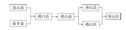
Fig. 1 Origin of Fangshan district图1 房山区由来 |
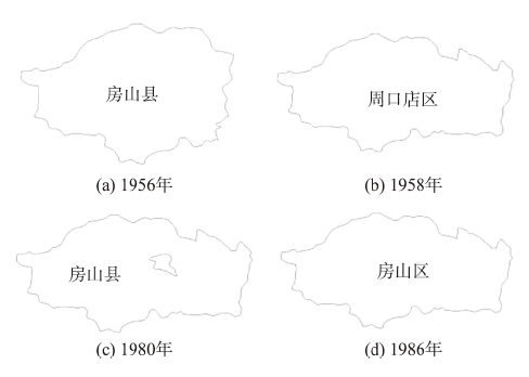
Fig. 2 Evolution of Fangshan district图2 房山区演变图 |
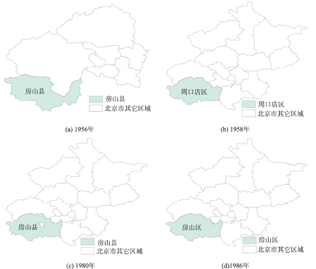
Fig. 3 Evolution of Beijing图3 北京市演变图 |
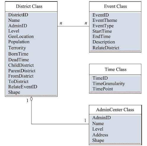
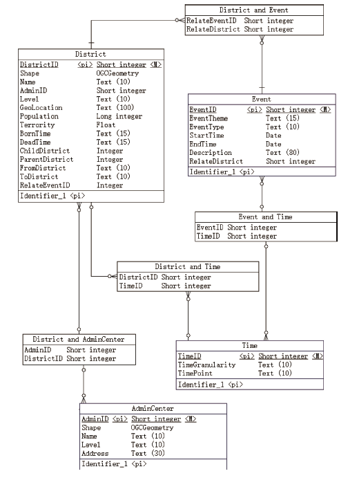
Fig. 4 Conceptual spatio-temporal data model of multi-granularity district图4 政区多粒度时空对象概念数据模型 |
Fig. 5 Logical spatio-temporal data model of multi-granularity district图5 北京政区多粒度时空对象逻辑模型 |
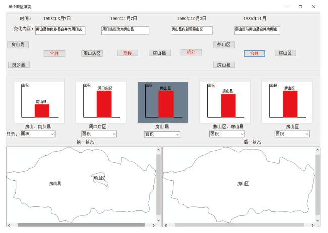
Fig. 6 Evolution of Fangshan district图6 房山区演变 |
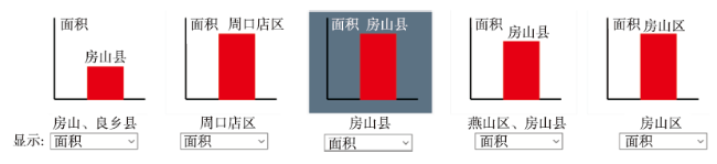
Fig. 7 Changes of area图7 面积变化 |
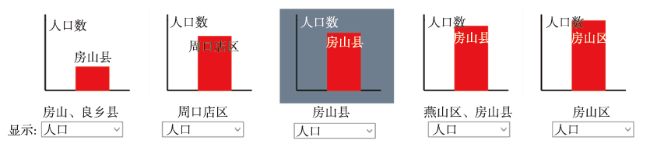
Fig. 8 Changes of population图8 人口变化 |
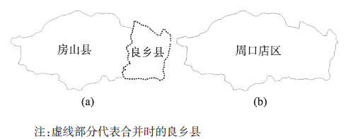
Fig. 9 District merging图9 政区合并 |
The authors have declared that no competing interests exist.
| [1] |
[
|
| [2] |
|
| [3] |
|
| [4] |
|
| [5] |
|
| [6] |
|
| [7] |
[
|
| [8] |
[
|
| [9] |
Spaccapietra. Editorial: Spatio-temporal data models and languages[J]. Geoinformatica,2001,5(1):5-9
|
| [10] |
[
|
| [11] |
[
|
| [12] |
|
| [13] |
[
|
| [14] |
|
| [15] |
[
|
| [16] |
|
| [17] |
[
|
| [18] |
[
|
| [19] |
[
|
| [20] |
[
|
| [21] |
[
|
| [22] |
[
|
| [23] |
[
|
| [24] |
[
|
| [25] |
[
|
| [26] |
[
|
/
| 〈 |
|
〉 |