
西安市城市边缘区空间识别与边界划分
作者简介:周小驰(1993-),女,辽宁锦州人,硕士生,研究方向为城乡规划与GIS应用研究。E-mail: zhouxiaochiecho@foxmail.com
收稿日期: 2017-04-19
要求修回日期: 2017-08-04
网络出版日期: 2017-10-20
基金资助
科技部科技支撑计划项目“产业延伸类城郊型美丽乡村建设综合技术集成与示范”(2015BAL01B04)
Spatial Recognition and Boundary Region Division of Urban Fringe Area in Xi’an City
Received date: 2017-04-19
Request revised date: 2017-08-04
Online published: 2017-10-20
Copyright
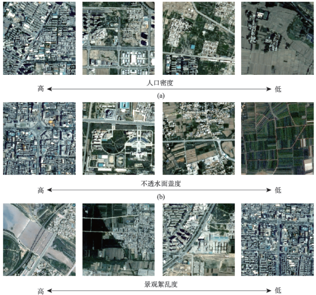
城市边缘区研究的首要任务是对城市边缘区进行空间识别和边界划分。针对现有研究存在的指标选取过于单一或繁杂、水陆分离导致划分间断等问题,利用西安市SPOT-5、Landsat TM遥感影像和社会统计数据,分别从物理、景观、人口3个视角出发,选定不透水面盖度与景观絮乱度作为主要判别指标,人口密度作为辅助指标,构建城市边缘区识别指标体系。运用信息熵法和突变检测法,量化并可视化西安市城市边缘区的空间范围。结果表明:① 所选取指标沿着城乡梯度表现出独特的空间信息,根据指标的城乡空间异质性特征可以识别出城市边缘区的空间范围,且方法更科学,界定结果更精确。② 西安市呈现出明显的城市核心区、城市边缘区、农村腹地的圈层结构特征。道路牵引与政策调控对城市边缘区的空间分布有重要影响。本研究可为城市边缘区其他相关研究提供科学参考和依据。
周小驰 , 刘咏梅 , 杨海娟 . 西安市城市边缘区空间识别与边界划分[J]. 地球信息科学学报, 2017 , 19(10) : 1327 -1335 . DOI: 10.3724/SP.J.1047.2017.01327
As a preparatory section for urban development, urban fringe area is not only a transitional area for both urban and rural areas, but also the most unstable region for urban development. In general, the primary task of urban fringe region study is to execute the spatial recognition and boundary division of urban fringe area. With the increased development of Geographic Information Systems (GIS) and satellite imagery technique, the definition of urban fringe area is becoming increasingly convenient and feasible. Owing to the existing one-fold or relatively complicated problems in extracting research indexes, it is of great significance to select better discrimination parameters in demarcating urban fringe. Based on SPOT-5 and Landsat-5 TM remotely sensed images and other corresponding auxiliary data, this study firstly constructed an evaluation framework and the index system of urban fringe area from the perspectives of physics, landscape and population, using the impervious surface coverage and the degree of landscape disturbance as primary indicators, and the population density data as auxiliary indexes. Then, the spatial range of the urban fringe of Xi'an city in 2010 was further quantified in this study by performing the computation of information entropy and mutation detection methods. The final results obtained are as follows: (1) The selected indexes show distinctive spatial signatures. The extraction model of urban fringe, which is based on the variability characteristics of both urban and rural areas, is practicable. Besides, the selected indicators are more scientific and accurate, which is of great significance in this paper. (2)Xi'an city takes on a clear ring and wedged structure of urban core area, urban fringe area, and rural hinterland. The extension of urban fringe area is primarily promoted by traffic facilities and policy orientation. This study can provide theoretical support and scientific basis for other relevant researches on urban fringe area.
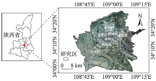
Fig. 1 The study area图1 研究区域 |
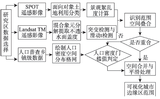
Fig. 2 Technology route of urban fringe extraction图2 城市边缘区提取技术路线图 |
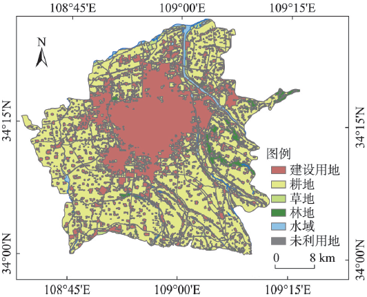
Fig. 3 The land use distribution map of Xi′an based on the object-oriented classification图3 基于面向对象分类的西安市土地利用图 |
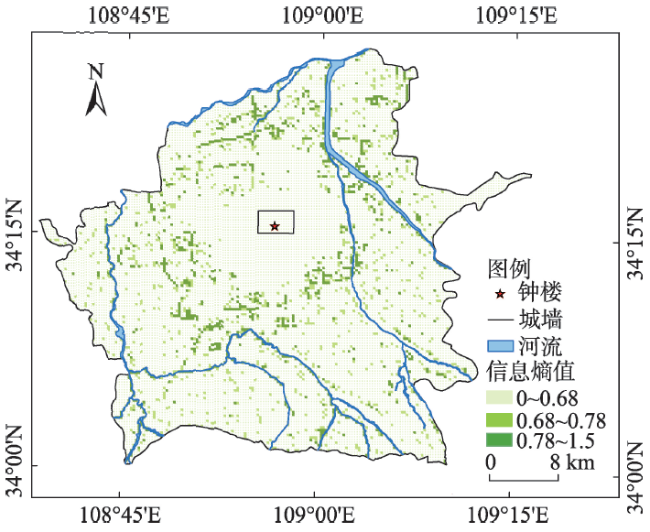
Fig. 4 The spatial distribution of degree of landscape disturbance based on 300 m×300 m grid cell图4 基于300 m×300 m网格单元的景观絮乱度空间分布格局 |
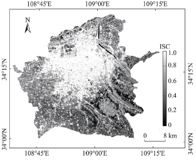
Fig. 5 The location of impervious surface fraction图5 西安市不透水面盖度的空间分布 |
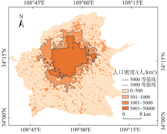
Fig. 6 Distribution of population density of Xi’an图6 第六次人口普查街道级西安市人口密度分布 |
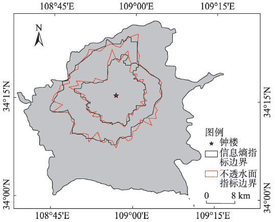
Fig. 7 Urban fringe obtained using two indicators图7 2种指标获取的城市边缘区范围 |
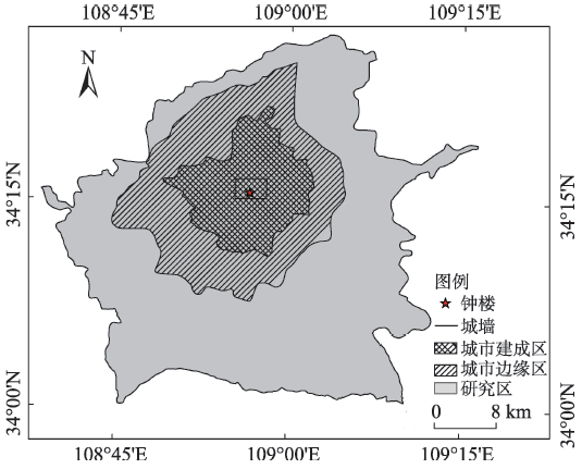
Fig. 8 Urban fringe in Xi′an图8 西安市城市边缘区空间范围图 |
Fig. 9 The gradients of each index of 1 km2 grid图9 各指标1 km2网格的梯度变化 |
The authors have declared that no competing interests exist.
| [1] |
[
|
| [2] |
|
| [3] |
|
| [4] |
[
|
| [5] |
[
|
| [6] |
[
|
| [7] |
[ Ma J, Li Q, Ying W. Identification of a rural-urban fringe based on wavelet transform: A case study of Wuhan[J].Geomatics and Information Science of Wuhan University, 2016,41(2) :235-241. ]
|
| [8] |
[
|
| [9] |
[
|
| [10] |
[
|
| [11] |
[
|
| [12] |
[
|
| [13] |
[
|
| [14] |
[
|
| [15] |
[
|
| [16] |
[
|
| [17] |
|
| [18] |
|
| [19] |
|
| [20] |
[
|
| [21] |
[
|
| [22] |
[
|
| [23] |
国务院发展研究中心.城乡空间边界划分的国际经验及启示[J].中国发展观察,2010(7):54-57.
[ Development Research Center of the State Council. Urban and rural space border demarcation of international experience and enlightenment[J]. China Development Observation, 2010,7:54-57. ]
|
/
| 〈 |
|
〉 |