
近40年来珠江河口区海岸线时空变化特征及驱动力分析
作者简介:刘旭拢(1978-),女,副研究员,主要从事海岸带环境遥感监测研究。E-mail: lxlong020@126.com
收稿日期: 2017-05-05
要求修回日期: 2017-07-16
网络出版日期: 2017-10-20
基金资助
广东省水利科技创新项目(2014-13,2016-08)
广东省科技计划项目(2016A020222006、2016A020210059、2017B020216001)
广东省自然科学基金项目(S2013010013320)
Spatiotemporal Evolution Characteristics of Coastlines and Driving Force Analysis of the Pearl River Estuary in the Past 40 Years
Received date: 2017-05-05
Request revised date: 2017-07-16
Online published: 2017-10-20
Copyright
海岸线对海平面上升、海岸侵蚀、港湾淤积、湿地生态资源、近海海域环境等具有重要的指示作用。利用遥感和GIS技术获取了珠江河口区1973-2015年8期海岸线数据,分析了海岸线长度、类型、空间位置的时空演化特征,提出岸线利用程度指数并定量分析人类活动对岸线的影响,最后对海岸线变化驱动力进行了探讨。结果表明:① 珠江河口区海岸线长度总体持续增加,岸线变化强度具有阶段性,1990年以前变化缓慢,1990-2000年为变化高峰期,2000年后变化强度减弱;② 1973-1990年珠江河口区以自然岸线为主,之后人工岸线成为主导岸线类型,建设围堤岸线1973年占总长度的7.09%,2015年所占比例增加到46.49%,在所有岸线类型中变化最大、比例最高;③ 研究期内,珠江河口区海岸线以向海域推进为主,年均速率达到39.10 m/a,鸡啼门-虎跳门段、磨刀门-鸡啼门段和蕉门-洪奇门段为向海延伸的热点区域;④ 40年来岸线利用程度指数稳定上升,1995年前增速较快,之后相对平缓。伶仃洋东岸岸线利用程度增幅最大;⑤ 口门整治、开发建设和围海养殖等人为活动是珠江口海岸线发生变化的主要原因,自然环境条件、人口和经济的增长以及政策因素是岸线演变的重要驱动力。
刘旭拢 , 邓孺孺 , 许剑辉 , 宫清华 . 近40年来珠江河口区海岸线时空变化特征及驱动力分析[J]. 地球信息科学学报, 2017 , 19(10) : 1336 -1345 . DOI: 10.3724/SP.J.1047.2017.01336
Coastline change detection is critical for analyzing the rise of sea levels, coastal erosion, harbor siltation, wetland ecological resources, and the offshore environment. Satellite remote sensing technology has a wide application and plays an indispensable role in coastline monitoring. The Pearl River Estuary is one of city groups with the high density population and the most developed economy in China. With the consistent increase of the reclamation and coastal zone exploitation, the coastline changes in the Pearl River Estuary are dramatic. In this paper, a set of Landsat images from 1973 to 2015 were collected to detect the coastline evolutions in the Pearl River Estuary. Firstly, the coastlines were divided into 8 categories and extracted with the aid of remote sensing and geographic information system (GIS) technologies. In addition, the spatiotemporal evolution characteristics of coastline length, categories, and spatial changes were analyzed during the study period. A coastline utilization index was proposed to determine the impact of human activities. Finally, the driving factors of coastline changes were discussed. The results are as follows: ① The total length of coastlines in the Pearl River Estuary increased by 135.46 km, which was equivalent to a growth of 3.15 km per year. The artificial coastline increased significantly, with a net increase of 315.94 km in length. The natural coastline constantly declined, with the most decrease in mud coastline. The change intensity of the coastline length showed remarkable periodicity. It was slow before 1990, peaked from 1990 to 2000, and then weakened after 2000. ② The coastline category was changed from natural coastline to artificial coastline in the study period. The natural coastline was the main coastline category before 1990, but the artificial coastline took the lead position thereafter. Among all coastline categories, the proportion of the construction coastline changed most dynamically, which increased from 7.09% in 1973 to 46.49% in 2015. ③ During the period of 1973-2015, the coastline showed a prevailing trend of advancing seaward, reaching an annual rate of 39.10 m. The seaward extension rate had significant difference in different area. The greatest extension speed appeared on the coastline between Jiti outlet and Hutiao outlet. The seaward extensions of the coastlines between Modao outlet and Jiti outlet, and between Jiao outlet and Hongqi outlet, were remarkable, too. Other regions had an advancing seaward but with a small magnitude. ④ In the past 40 years, the coastline utilization index grew stably. The growth rate increased markedly from 1973 to 1995 and changed gently after 1995. The coastline utilization index in the east coast of the Lingding Sea occupied the largest increasing extent because more and more natural coastline had been artificialized. ⑤ The coastlines in the Pearl River Estuary are affected mainly by human activities, such as outlet renovation, coastal zone construction, and sea farming. Environmental conditions, demographic and economic growth, as well as policies are important driving forces of coastline changes. This study will provide scientific support for the coastline change detection, coastal zone management and sustainable development in the coastal area.
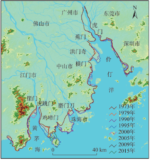
Fig. 1 The coastline distribution of the Pearl River Estuary from 1973 to 2015图1 1973-2015年珠江河口地区海岸线空间分布 |
Tab. 1 The grading coefficients for different coastline classes表1 不同岸线类型分级系数 |
| 岸线类型 | 基岩岸线、砂质岸线、淤泥质岸线和生物岸线 | 围而未用岸线 | 农业围垦岸线、养殖围垦岸线 | 建设围堤岸线 |
|---|---|---|---|---|
| 分级系数 | 0.05 | 0.20 | 0.5 | 0.95 |
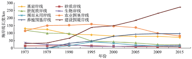
Fig. 2 The length of coastline in the Pearl River Estuary from 1973 to 2015图2 1973-2015年珠江河口区不同类型海岸线长度统计 |
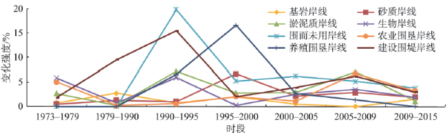
Fig. 3 The intensity of coastline length changes of the Pearl River Estuary from 1973 to 2015图3 1973-2015年珠江河口区不同类型海岸线长度变化强度 |
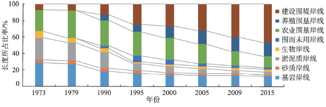
Fig. 4 The coastline structural changes of the Pearl River Estuary from 1973 to 2015图4 1973-2015年珠江河口区海岸线构成变化 |
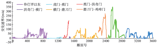
Fig. 5 The coastline change rates of the Pearl River Estuary from 1973 to 2015图5 1973-2015年珠江河口区海岸线变化速率 |
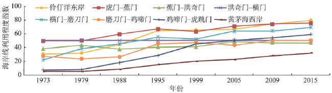
Tab. 2 The coastline utilization index of the Pearl River Estuary from 1973 to 2015表2 1973-2015年珠江河口区海岸线利用程度指数 |
| 年份 | ||||||||
|---|---|---|---|---|---|---|---|---|
| 岸线利用指数 | 1973 | 1979 | 1990 | 1995 | 2000 | 2005 | 2009 | 2015 |
| 22.95 | 27.15 | 34.12 | 45.41 | 48.24 | 52.46 | 57.01 | 60.86 | |
Fig. 6 The coastline utilization changes of the Pearl River Estuary from 1973 to 2015图6 1973-2015年珠江河口区不同口门海岸线利用程度变化 |
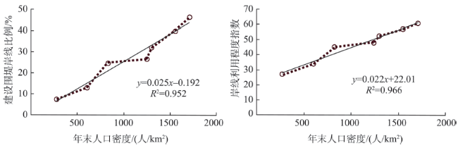
Fig. 7 The relationship among the population growth, the construction coastline and the coastline utilization extents图7 人口增长与建设围堤岸线比例、岸线利用程度之间的关系模式 |
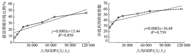
Fig. 8 The relationship among the economic growth, the construction coastline and the coastline utilization extents图8 经济增长与建设围堤岸线比例、岸线利用程度之间的关系模式 |
The authors have declared that no competing interests exist.
| [1] |
|
| [2] |
[
|
| [3] |
|
| [4] |
[
|
| [5] |
|
| [6] |
|
| [7] |
|
| [8] |
|
| [9] |
[ Liu X, Ma Y Y, Li G X, et al. Coastline evolution of the Yangtze estuary upon satellite remote sensing analysis[J]. Marine Geology Quaternary Geology, 2013,33(2):17-23. ]
|
| [10] |
[
|
| [11] |
|
| [12] |
[
|
| [13] |
[
|
| [14] |
[
|
| [15] |
[
|
| [16] |
[
|
| [17] |
|
| [18] |
[
|
| [19] |
[
|
| [20] |
中国人民共和国国家标准.GB/T18190-2000海洋学术语海洋地质学[S].北京:中国标准出版社,2000.
[ National standard of the people's Republic of China.GB/T18190-2000 Oceanographic terminology marine geology[S]. Beijing: Standard Press of China, 2000. ]
|
| [21] |
[ Zhang X K, Zhang X, Yang B H, et al. Coastline extraction using remote sensing based on coastal types and tidal correction[J]. Remote Sensing for Land and Resources, 2013,25(4):91-97. ]
|
| [22] |
[ Liu S W, Zhang J, Ma Y, et al. Coastline extraction method based on remote sensing and DEM[J]. Remote Sensing Technology and Application, 2011,26(5):614-618. ]
|
| [23] |
[
|
| [24] |
[ Gao Y, Wang H, Su F Z, et al. Spatial and temporal of continental coastline of china in recent three decades[J]. Acta Oceanologica Sinica, 2013,35(6):31-42. ]
|
| [25] |
[
|
| [26] |
|
| [27] |
[
|
| [28] |
[ Zhang X X, Wang W W, Yan C Q, et al. Study on spatio-temporal evolution of historical coastline in Jiangsu coastal area in the past 1000 years[J]. Scientia Geographica Sinica, 2014,34(3):344-351. ]
|
| [29] |
|
/
| 〈 |
|
〉 |