
结合POI数据的道路自动选取方法
作者简介:徐智邦(1991-),男,硕士生,主要从事地图自动综合研究。E-mail: xuxugis@foxmail.com
收稿日期: 2017-08-21
要求修回日期: 2017-11-07
网络出版日期: 2018-03-02
基金资助
国家自然科学基金项目(41561090、41371435)
A Method for Automatic Road Selection Combined with POI Data
Received date: 2017-08-21
Request revised date: 2017-11-07
Online published: 2018-03-02
Supported by
National Natural Science Foundation of China, No.41561090, 41371435
Copyright
人们对道路重要性的认知与道路周边设施有重要关系,针对现有地图综合道路选取方法中对语义特征考虑不足的问题,将POI数据引入到道路的语义特征分析中,提出一种综合考虑道路空间特征和语义特征的道路综合自动选取方法。首先,结合POI位置数据构造了道路语义特征度量的3个新参量:设施点密度、重要设施比率和专题设施比率;然后,与道路长度、连接值、总深度值、平均线密度等反映道路几何、拓扑和分布特征的度量参量一起,通过归一化和熵值法赋权进行整合计算,得到道路重要性值;最后,综合考虑道路重要性值、道路stroke构成和stroke连通度的约束条件进行道路的分步选取。实验结果表明,该方法在保留主要道路、保持道路分布疏密特征和道路连通性的同时,较好地顾及了道路的语义特征信息。
徐智邦 , 王中辉 , 闫浩文 , 武芳 , 段晓旗 , 孙立 . 结合POI数据的道路自动选取方法[J]. 地球信息科学学报, 2018 , 20(2) : 159 -166 . DOI: 10.12082/dqxxkx.2018.170385
People's cognition of the importance of roads is closely related to the facilities around the road. Aiming at the problem of lack of semantic features in the existing study on automatic selection in road generalization, the POI data is introduced into the semantic feature analysis of the road. A method of road automatic selection considering road spatial and semantic feature is proposed. Firstly, three new parameters of the road semantic feature measure are constructed by combining the POI position data. Then, three new parameters are combined with other metric parameters such as connection values and average linear density to calculate the road importance values. Finally, the road importance values, the composition of road stroke and the stroke connectivity are regarded as the constraint condition of automatic selection. The road is selected step by step. The experimental results show that the proposed method takes into account the semantic features of the road while retaining the main road, maintaining the density of the road distribution and the connectivity of the road.
Key words: automatic selection of roads; POI data; semantics; map generalization
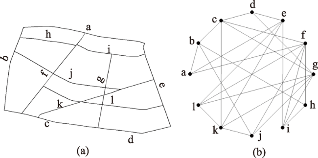
Fig. 1 Two types of abstractions of road networks图1 2种路网抽象方法 |
Tab. 1 Metric parameters of spatial characteristics of road network表1 道路网空间特征的度量参量 |
| 指标 | 解释 | 计算公式 | 变量含义 |
|---|---|---|---|
| 道路长度 | 指一条道路的几何长度 | ||
| 道路宽度 | 指一条道路的几何宽度 | ||
| 连接值 | 指与一条道路相交的其他道路总数。目前普遍认为道路的连接值可以反映道路的重要性[14] | 表示道路的连接值;表示与道路直接相连的其他道路总数 | |
| 控制值 | 表示一条道路对其邻接道路的控制程度或者说是影响程度 | 表示道路的控制值;是与道路直接相连的其他道路的集合;表示道路的连接值 | |
| 总深度值 | 表示空间系统中某节点到达其他所有节点所需要的最小步数总和(步数指拓扑空间的值,即两个邻接节点的距离为一步)通常认为,节点的总深度值越小其在空间系统中越便捷 | TDi表示道路的总深度值;表示道路总数;表示道路到道路的最小步数 | |
| 全局集成度 | 反映一条道路与系统内所有其他道路联系的紧密程度,表现了在整个系统中一条道路对其他道路的可达程度 | 表示道路的全局集成度;表示道路的平均深度值;表示道路总数 | |
| 平均线密度 | 线密度表示单位区域内的线状要素的密度,平均线密度指一条道路所经过区域的线密度的平均值 | | 表示道路上个结点的线密度平均值;表示线密度;为单位区域内线的长度;为单位区域的面积 |
Tab. 2 Classification of POI function表2 POI功能分类 |
| 设施类别 | 包含的设施场所 |
|---|---|
| 居住类 | 住宅、小区及相应服务设施 |
| 公共管理类 | 政府机关、行政办公 |
| 公共服务类 | 图书馆、文化馆、各级院校科研单位、医疗、体育场、福利院、古迹、宗教、外事用地 |
| 商业服务业类 | 商业、商务、娱乐、油气、电信、邮政等服务设施 |
| 工业类 | 工矿企业 |
| 物流仓储类 | 仓库、附属停车场等 |
| 交通类 | 海陆空场站、停车场等 |
| 公用设施类 | 供电、水、气、热等设施、污水处理、公厕等;消防、防洪 |
| 绿地广场类 | 公园、广场等 |
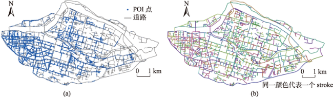
Fig. 2 POI distribution of roads (a) and road network stroke model (b)图2 道路周边POI分布(a)及道路网stroke模型(b) |
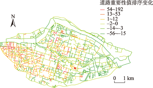
Fig. 3 Ranking changes of road importance values after considering the POI facilities around the road图3 考虑道路周边POI设施点前后道路重要性值的排序变化 |
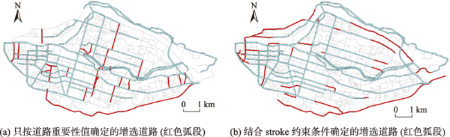
Fig. 4 Comparison of road selection results combined with stroke constraints图4 是否结合stroke约束条件的道路选取对比 |
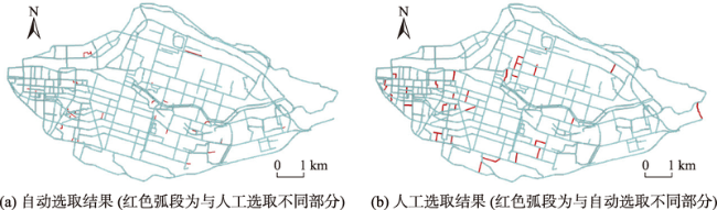
Fig. 5 Comparison between automatic selection results and manual selection results图5 自动选取和人工选取结果对比 |
Tab. 3 Comparison of two selection results表3 自动选取与人工选取结果比较 |
| 参数 | 数值 |
|---|---|
| 人工选取后道路总长度/ km | 248.052 |
| 自动选取后道路总长度/ km | 242.129 |
| 2种方法选取一致的道路的总长度/ km | 236.569 |
| 最大相似度 | 0.933 |
| 选取一致的弧段数占选取总数的比例/% | 88.93 |
The authors have declared that no competing interests exist.
| [1] |
|
| [2] |
|
| [3] |
|
| [4] |
|
| [5] |
|
| [6] |
[
|
| [7] |
[
|
| [8] |
[
|
| [9] |
|
| [10] |
|
| [11] |
[
|
| [12] |
[
|
| [13] |
[
|
| [14] |
[
|
| [15] |
[
|
| [16] |
[
|
| [17] |
|
| [18] |
|
| [19] |
[
|
| [20] |
|
| [21] |
[
|
| [22] |
[
|
| [23] |
|
/
| 〈 |
|
〉 |