
珠江三角洲传统村落生态侵蚀时空演变特征
作者简介:黄 铎(1973-),男,湖北荆州人,博士,讲师,研究方向为城市规划中数字技术及应用。E-mail: huang-duo@qq.com
收稿日期: 2017-09-20
要求修回日期: 2017-12-27
网络出版日期: 2018-03-20
基金资助
资源与环境信息系统国家重点实验室开放课题
亚热带建筑科学国家重点实验室自主课题(2016KD21)
Spatio-temporal Evolution and Model of Ecological Erosion in Traditional Villages in the Pearl River Delta
Received date: 2017-09-20
Request revised date: 2017-12-27
Online published: 2018-03-20
Supported by
Open Subject of State Key Laboratory of Resources and Environment Information System
Independent Subject of State Key Laboratory of Subtropical Building Science, No.2016KD21.
Copyright
传统村落的保护随着中国第四批保护名录的公布逐渐成为全社会的共识。传统村落是人类与自然环境长期相互作用与有机融合的产物,其周边农田、山林、水塘等自然生态环境使着传统村落生产及生活活动得以延续。1978年改革开放后,快速城市化的背景下,不同背景下的城乡建设使得传统村落周边生态自然环境不断遭受到侵蚀威胁,为其整体保护带来极大的挑战。为开展快速城市化背景下传统村落生态环境的影响研究,本文首先界定了传统村落生态侵蚀的概念,应用侵蚀动力学理论对自我生态侵蚀、外来生态侵蚀、突发性生态侵蚀与生态侵蚀修复4种生态侵蚀方式提出生态侵蚀演变的4种模型,同时以珠江三角洲中国传统村落为研究案例,从时间和空间上对珠江三角洲地区传统村落生态侵蚀情况进行分析,探讨其生态侵蚀演变规律,揭示快速城市化背景下传统村落生态侵蚀的时空演变特征,总结了“城镇建设外侵模式、村落建设扩张模式、道路交通占领模式、综合发展模式”4种传统村落生态侵蚀的用地演化模式,丰富和深化传统村落生态视角的研究,为传统村落的保护和相关规划提供了重要参考。
黄铎 , 孙莹 , 张世君 , 魏成 . 珠江三角洲传统村落生态侵蚀时空演变特征[J]. 地球信息科学学报, 2018 , 20(3) : 340 -350 . DOI: 10.12082/dqxxkx.2018.170436
Protecting traditional villages has gradually become the consensus of the whole society due to the announcement of the fourth batch of protection lists in China. Traditional villages are the product of the long-term interaction and organic fusion between human and natural environment. Such natural and ecological environments as the surrounding farmlands, mountains, forests and ponds maintain the production and living activities of traditional villages. However, against the backdrop of rapid urbanization after reform and opening up, the ecological environment around the villages is being threatened by increasingly serious erosion because of continuous urban and rural constructions. Urban and rural constructions also bring great challenges to the protection of traditional villages. We first define the concept of ecological erosion in traditional villages. After applying the theory of erosion dynamics, we analyze four ecological erosion ways, including self-ecological erosion, external ecological erosion, sudden ecological erosion and ecological erosion restoration. We also put forward four theoretical models of ecological erosion evolution. At the same time, according to analysis of the satellite images of ecological patches in different years, we take the traditional villages in the Pearl River Delta as the research case, analyze the ecological erosion based on various times and areas, discuss the evolvement law of ecological erosion and its temporal and spatial evolution characteristics in traditional villages under rapid urbanization. We summarize four models of ecological erosion in traditional villages, including "urban construction exterior invasion mode", "village construction expansion model", "road traffic occupation mode" and" comprehensive development model". As an effort to enrich and deepen the researches on traditional villages from ecological perspective, we provide an important reference for the protection and planning of traditional villages.
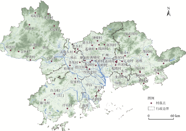
Fig. 1 The distribution of 45 national traditional villages of the first three batches in the Pearl River China图1 珠江三角洲地区前三批45个国家传统村落分布图 |
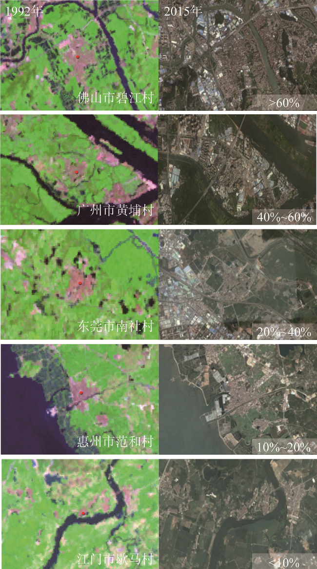
Fig. 2 Changes of typical traditional villages under different degrees of ecological erosion图2 不同生态侵蚀程度下传统村落的生态环境变化情况 |
Tab. 1 Results of ecological erosion of traditional villages from 1992 to 2015表1 1992-2015年传统村落的生态侵蚀结果 |
| 生态侵蚀程度 | <10% | 10%~20% | 20%~40% | 40%~60% | >60% |
|---|---|---|---|---|---|
| 村落个数 | 15 | 10 | 9 | 9 | 2 |
| 村落名称 | 惠州市周田村、肇庆市扶溪村、肇庆市罗洪村、江门市良溪村、广州市莲塘村、江门市自力村、肇庆市孔洞村、肇庆市金林村、广州市钱岗村、江门市浮石村、肇庆市古蓬村、江门市歇马村、肇庆市杨池村、广州市新围村、广州市钟楼村 | 惠州市墨园村、东莞市江边村、惠州市范和村、肇庆市邓屋村、惠州市皇思扬村、佛山市大旗头村、广州市港头村、惠州市旭日村、广州市塱头村、肇庆市大屋村 | 中山市古鹤村、东莞市龙背岭村、广州市聚龙村、肇庆市白石村、深圳市鹏城村、惠州市绳武村、东莞市南社村、广州市小洲村、广州市瓜岭村 | 东莞市塘尾村、东莞市超朗村、中山市翠亨村、广州市沙湾北村、佛山市茶基村、佛山市松塘村、广州市黄埔村、广州市大岭村、惠州市茶园村 | 东莞市西溪村、佛山市碧江村 |
Tab. 2 Changes of ecological erosion amounts of traditional villages in different time intervals(km2)表2 各时段传统村落生态侵蚀量变化情况(km2) |
| 时段 | Mean | Std.Dev | Max |
|---|---|---|---|
| 1992-1997 | 0.2285 | 0.3041 | 1.0279 |
| 1997-2002 | 0.1859 | 0.2514 | 1.0803 |
| 2002-2007 | 0.1758 | 0.2316 | 1.0123 |
| 2007-2012 | 0.0910 | 0.1369 | 0.4228 |
| 2012-2015 | 0.0586 | 0.0848 | 0.2983 |
Tab. 3 Spatial distribution and statistics of the changes of ecological erosion amounts of traditional villages表3 各时段传统村落生态侵蚀量变化空间分布情况 |
| 时段 | Z score | P value | Type |
|---|---|---|---|
| 1992-1997 | 4.32 | <0.01 | HH |
| 1997-2002 | 5.98 | <0.01 | HH |
| 2002-2007 | 3.63 | <0.01 | HH |
| 2007-2012 | 0.321 | 0.74 | Random |
| 2012-2015 | 0.003 | 0.97 | Random |
| 1997-2015 | 5.50 | <0.01 | HH |
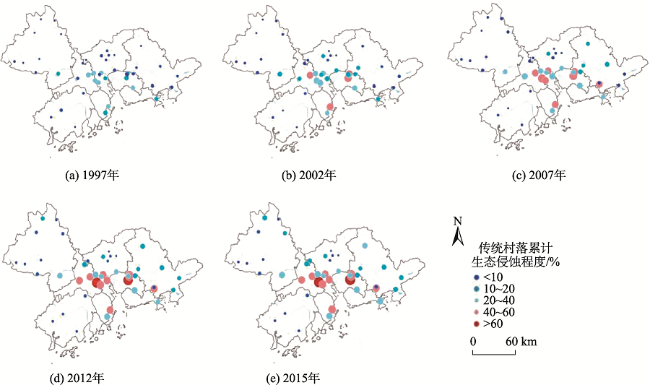
Fig. 3 Spatial evolution of ecological erosion in traditional villages of different periods in the Pearl River Delta图3 珠江三角洲各时相传统村落生态侵蚀的空间演变 注:以1992年为基准年,计算得到1997,2002,2007,2012,2015年5个时相各村落的生态侵蚀程度 |
Fig. 4 Spatial patterns of ecological erosion of traditional villages in the Pearl River Delta Region图4 珠江三角洲地区传统村落生态侵蚀的空间模式 |
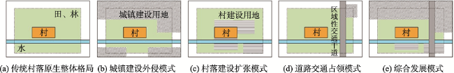
Tab. 4 The evolution patterns of traditional villages in the Pearl River Delta表4 珠江三角洲传统村落生态侵蚀的用地演化模式 |
| 演变模式 | 演变结果 | 典型村落 |
|---|---|---|
| 城镇建设外侵模式 | 外围城镇迅速推进,村落生态用地面积不断被蚕食 | 东莞市西溪村、东莞市超朗村、东莞市塘尾村、肇庆市白石村 |
| 村落建设扩张模式 | 村落内部建设用地增加,生态用地面积不断减少 | 佛山市松塘村、广州市大岭村、东莞市南社村、中山市翠亨村 |
| 区域性道路割裂模式 | 区域性道路交通建设,使得村落周边的生态网络与生态联系被交通割裂 | 广州市钟楼村、广州市钱岗村、东莞市龙背岭村、广州市瓜岭村 |
| 综合发展模式 | 村落面积减小,村建设用地大幅增加,原有生态用地锐减;城市生态修复活动使生态用地有所增加 | 广州市黄埔村、佛山市碧江村、佛山市茶基村、广州市沙湾北村 |
The authors have declared that no competing interests exist.
| [1] |
[
|
| [2] |
[
|
| [3] |
|
| [4] |
|
| [5] |
[
|
| [6] |
[
|
| [7] |
[
|
| [8] |
[
|
| [9] |
[
|
| [10] |
[
|
| [11] |
[
|
| [12] |
[
|
| [13] |
[
|
| [14] |
[
|
| [15] |
[
|
| [16] |
[
|
| [17] |
[
|
| [18] |
[
|
| [19] |
[
|
| [20] |
[
|
| [21] |
[
|
| [22] |
[
|
| [23] |
[
|
| [24] |
[
|
| [25] |
[
|
| [26] |
[
|
| [27] |
[
|
| [28] |
[
|
| [29] |
[
|
| [30] |
[
|
| [31] |
[
|
| [32] |
[
|
| [33] |
[
|
| [34] |
[
|
/
| 〈 |
|
〉 |