
基于面向对象方法的Sentinel-1A SAR在洪水监测 中的应用
作者简介:汤玲英(1992-),女,硕士生,研究方向为生态遥感应用研究。E-mail: 595834337@qq.com
收稿日期: 2017-12-15
要求修回日期: 2018-01-14
网络出版日期: 2018-03-20
基金资助
国家自然科学基金项目(41501478)
湖南省重点学科地理学(2016001)
湖南省自然科学基金项目(2015JJ6068)
Flooding Monitoring Application Based on the Object-oriented Method and Sentinel-1A SAR Data
Received date: 2017-12-15
Request revised date: 2018-01-14
Online published: 2018-03-20
Supported by
National Natural Science Foundation of China, No.41501478
Construction Program of the Key Discipline in Hunan Province, No.2016001
National Natural Science Foundation of Hunan China, No.2015JJ6068.
Copyright
开展Sentinel-1A SAR数据在洪水淹没范围提取和水体变化监测方面的应用研究,对科学有效地管理洪涝灾害有重要意义。合成孔径雷达以其不受天气影响、能穿透云层、覆盖面积广等特点成为灾害监测的重要数据来源。面向对象的方法能有效解决影像的椒盐现象被广泛运用于信息提取研究。本文基于Sentinel-1A SAR数据,利用面向对象的方法构建洪水淹没范围提取流程,绘制灾前、灾中、灾后水体变化监测图,对比分析基于传统像元的提取方法,实现对广西临桂会仙岩溶湿地区域不同时期洪水动态监测。研究表明,Sentinel-1A SAR数据在洪水监测领域有巨大的应用潜力,相较于传统基于像元的方法,面向对象的方法能有效抑制杂斑生成,提高空间信息的利用效率,具有更好的提取精度。
汤玲英 , 刘雯 , 杨东 , 陈乐 , 苏扬媚 , 徐宪立 . 基于面向对象方法的Sentinel-1A SAR在洪水监测 中的应用[J]. 地球信息科学学报, 2018 , 20(3) : 377 -384 . DOI: 10.12082/dqxxkx.2018.170599
In recent years, flood disasters have emerged successively, so extracting the disaster range and studying detection of the change of water body are of great significance to the scientific and effective management of flood disasters. Synthetic Aperture Radar (SAR) has the ability of penetrating clouds and generating ground information and it can collect data from large areas under any weather conditions. SAR has become an important means of natural disasters observation. Sentinel-1A is an important part of satellite in ESA's Copernicus Programm for monitoring environment. Therefore, discussions of the application of Sentinel-1A SAR data to the monitoring of flood disaster is meaningful. The traditional pixel-based methods have limitation in image speckle noise suppression, so the object-oriented method is introduced in this study. This study takes Sentinel-1A SAR images of the pre-flood, flooding and after-flood periods as data source. We introduce the object-oriented classification software - eCognition 9.0 to establish an extraction process of flooding area. Firstly, we use the SNAP software to preprocess the Sentinel-1A SAR images. Then, to account for objects features, we conduct experiments using multi-scale segmentation of eCognition 9.0, comparative analysis of the experimental results and we use the prior knowledge to determine the optimal segmentation scale. Based on the assigned class function of eCognition 9.0, we analyze the VV polarization mean feature to extract flooding area. Meanwhile, we use DEM data to remove the hill-shade in water extraction. Using the methods above, the detection of flood dynamic changes of different periods and flood submerge area extracted in the Huixian karst wetland in Guangxi was realized. Maps of the detection of flood changes in the pre-flood, flooding and after-flood periods were plotted. At last, we compared the traditional pixel-based water extraction method (Unsupervised classification and OSTU threshold segmentation). This research shows that Sentinel-1A SAR data has a great application potential in flood detection field. Compared with the traditional pixel-based method, the object-oriented method can effectively avoid the “salt and pepper phenomenon”, have high precision in flooding area extraction and can improve the utilization of spatial information.
Key words: Sentinel-1A SAR; flood; object-oriented; flood submerge area; Karst
Tab. 1 Characteristics of processed Sentinel-1A images表1 处理的Sentinel-1A影像的特征 |
| 获取卫星 | Sentinel-1A |
|---|---|
| 极化方式 | VV/VH |
| 地距分辨率/m | 20×22(方位向×距离向) |
| 像元大小/m | 10×10(方位向×距离向) |
| 工作模式 | 干涉宽幅 (宽幅250 km) |
| 入射角度/° | 30.797~46.22 |
| 影像时间 | 2016年4月03日 (灾前) 2016年5月21日 (灾中) 2016年6月14日 (灾中) 2016年8月25日 (灾后) 2017年5月28日 (灾前) 2017年7月03日 (灾中) 2017年7月15日 (灾后) |
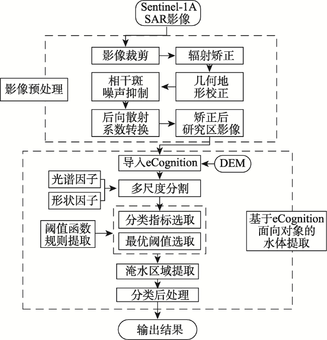
Fig. 1 Flowchart of flooding area extraction from Sentinel-1A SAR data based on the object-oriented method图1 基于面向对象的Sentinel-1A SAR数据洪水淹没范围提取流程图 |
Fig. 2 Original images of flood and images after processing on July 3, 2017图2 2017年7月3日洪水期原始影像和预处理后的影像 |
Fig. 3 The flooding area extraction results in the study area during early July, 2017图3 研究区域2017年7月上旬洪水淹没范围提取结果图 注:蓝色区域为7月3日淹水区域,黄色区域为5月28日灾前水体,红色为7月15日灾后水体 |
Fig. 4 The flooding area extraction results in May and June, 2016图4 2016年5、6月淹水提取结果 |
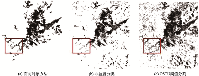
Fig. 5 Flooding area extraction results based on different classifications图5 基于不同分类方法的淹水范围提取 |
The authors have declared that no competing interests exist.
| [1] |
[
|
| [2] |
[
|
| [3] |
[
|
| [4] |
|
| [5] |
[
|
| [6] |
|
| [7] |
[
|
| [8] |
[
|
| [9] |
[
|
| [10] |
[
|
| [11] |
[
|
| [12] |
[
|
| [13] |
|
| [14] |
[
|
| [15] |
[
|
| [16] |
[
|
| [17] |
[
|
| [18] |
[
|
| [19] |
[
|
| [20] |
[
|
/
| 〈 |
|
〉 |


