地球信息科学理论与方法

基于纹理数据和SCSG-BR表示的城市建筑物混合 建模

  • 周国清 , 1 ,
  • 黄煜 1, 2 ,
  • 岳涛 , 1, 2, * ,
  • 王浩宇 1, 2 ,
  • 贺朝双 1, 2 ,
  • 李晓柱 1, 2
展开
  • 1. 桂林理工大学 广西空间信息与测绘重点实验室,桂林 541004
  • 2. 桂林理工大学 测绘地理信息学院,桂林 541004
*通讯作者:岳 涛(1987-),男,硕士,主要从事摄影测量与遥感、三维建模等研究。E-mail:

作者简介:周国清(1965-),男,博士,教授,主要从事摄影测量与遥感、激光雷达等研究。E-mail:

收稿日期: 2017-11-30

  要求修回日期: 2018-02-09

  网络出版日期: 2018-04-20

基金资助

国家自然科学基金项目(41431179)

广西自然科学基金项目(2015GXNSFDA139032)

Hybrid Modeling for Urban Buildings Based on Textures and SCSG-BRs Representation

  • ZHOU Guoqing , 1 ,
  • HUANG Yu 1, 2 ,
  • YUE Tao , 1, 2, * ,
  • WANG Haoyu 1, 2 ,
  • HE Chaoshuang 1, 2 ,
  • LI Xiaozhu 1, 2
Expand
  • 1. Guangxi Key Laboratory of Spatial Information and Geomatics, Guilin University of Technology, Guilin 541004, China
  • 2. College of Geomatics and Geoinformation, Guilin University of Technology, Guilin 541004, China
*Corresponding author: YUE Tao, E-mail:

Received date: 2017-11-30

  Request revised date: 2018-02-09

  Online published: 2018-04-20

Supported by

National Natural Science Foundation of China, No.41431179

Guangxi Natural Science Foundation, No.2015GXNSFDA139032.

Copyright

《地球信息科学学报》编辑部 所有

摘要

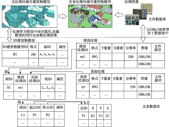
随着城市建设的迅猛发展,城市建筑物建模的复杂性和实景化要求越来越高。因此,进行高精度的城市建筑物建模,建立有效的数据结构成为一项具有挑战性的工作。针对结构实体几何(Constructive Solid Geometry, CSG)模型建模的局限性,本文提出了一种结合CSG和BR(Boundary Representation)的混合建模方法。该方法改进传统的CSG为“空间CSG(SCSG)”,利用维度扩展的九交模型(DE-9IM)表示体元间的拓扑关系,确定唯一的SCSG树来表示城市建筑物的外部结构,同时用BR表示城市建筑物几何要素间的拓扑关系。然后,本文结合文件数据库和关系数据库来联合管理模型数据。关系数据库存储模型和纹理的属性信息;文件数据库存储模型和纹理图像。在存储和调用纹理影像时,关系数据库中的面ID将城市建筑模型ID和纹理ID关联,纹理图像和城市建筑模型同时被加载和存储。另外,本文采用最小二乘法对建筑物多边形进行正交化和拓扑调整处理,以保证模型数据的精确性。本文选择美国科罗拉多州丹佛地区和瑞士苏黎世地区的数据进行实验,并根据不同的建模方法进行模型加载耗时的比较,证明本文提出的方法耗时较少。实验结果表明,该混合建模方法不仅可以有效地表示实体的拓扑关系,还可以加快纹理加载,实现建筑物的快速精确建模,有效实现空间查询。

本文引用格式

周国清 , 黄煜 , 岳涛 , 王浩宇 , 贺朝双 , 李晓柱 . 基于纹理数据和SCSG-BR表示的城市建筑物混合 建模[J]. 地球信息科学学报, 2018 , 20(4) : 543 -551 . DOI: 10.12082/dqxxkx.2018.170574

Abstract

With the complexity of and the photorealistic requirement for urban buildings in rapid development of urbanization, the high accuracy of modeling for 3D urban buildings and the establishment of an effective data structure for those complicated building becomes a challenging work. With consideration of the shortage of the current CSG (Constructive Solid Geometry) modeling, this paper presents a hybrid modeling, which combines CSG and BR (Boundary Representation). In the proposed model, the traditional CSG model is improved by what is known as "Spatial CSG (SCSG)", which uses the dimensionally extended Nine-Intersection model (DE-9IM) to represent the topological relations between voxels and determines the unique SCSG tree to represent the exterior shape of the buildings. And then, the BR is used to represent the topological relationship between geometric elements of the urban buildings, which considers the texture as the attribute data of the wall and the top and combines SCSG as SCSG-BR method. This proposed method combines the file database and the relational database to manage the data of three-dimensional (3D) buildings. The attribute information of the building model and the texture are stored in the relational database. The file database contains a model file and a texture image file, which are used to store the building and the texture image. The texture images are separately stored in another relational database by a variable-length binary data type. During the storage and recall of texture images, the urban building model ID and the texture ID are linked through face ID in relational database. The texture images and the urban building model are loaded and stored at the same time. Thus, the management method has less complex processes in texture mapping and improves the model loading speed. In the data processing, the least squares algorithm is used to normalize the building polygons, and adjust the polygon topology to ensure the accuracy of the modeled data. Data sets, located in Denver, Colorado, USA, and Zurich, Switzerland, are selected to validate our method. The time-consuming comparison of model loading using the different modeling methods are conducted, and the experimental results demonstrated that our method consumes least time out of all methods. The experimental results also demonstrated that the hybrid modeling method proposed in this paper can not only accurately represent the topological relations of the building entities, but also quickly load the building texture images, which is capable to achieve fast and accurate modeling buildings, and effectively realize spatial query.

1 引言

随着数字城市的不断发展,城市建筑物建模的要求越来越高。由于建筑物形状的复杂程度不同,复杂建筑物的精确建模会产生很大的困难,因此需要对复杂建筑物建立有效的数据模型,正确地表示复杂建筑物的空间拓扑关系,从而快速实现城市建筑物模型的精确建模,为数字城市的发展提供有效数据。
国内外的学者对建筑物的三维建模做了大量的研究。Gruen等[1]设计了一种拓扑生成器CC-Modeler,通过改正概率松弛方程来拟合平面并进行最小二乘调整,最终获得建筑物模型。Mathias等[2] 使用文法驱动建模方法,并根据模型形状语法重建完整的建筑物。Mao等[3]提出了使用城市树作为城市三维模型的数据结构。该方法首先生成建筑物平面图,再简化平面图,然后将建筑集群,并创建城市树,最后进行可视化,生成城市三维模型。Sugihara[4]提出了一个GIS和CG的集成系统实现建筑物多边形(建筑物廓)的3D建筑模型的自动生成方法,该方法通过骨架线计算来自动生成有屋顶形状的3D建筑模型。Baig等[5]提出了构建建筑物的三维模型的三步策略,首先进行建筑物最小边的简化,然后使用P-树凸包技术进行平面聚合,最后重建建筑物泛化模型。Sasaki等[6]讨论了如何从给定的一组Facetons模型中计算网络多边形模型,以此来构建建筑物模型。Sugihara等[7]通过构建改正多边形自动生成三维建筑模型。但该方法创建三维建筑模型假设多边形是正交的,不适用于非正交多边形。王继水等[8]提出了一种改进的CSG建模方法-体素生长法,并提出了基于结构实体几何模型(Constructive Solid Geometry, CSG)和边界表示法(Boundary Representation, BR)的混合建模方法,用CSG模型表达外部形体,用BR表达内部关系,精细表达建筑物的结构。在数据集成方面,Zhou等[9]提出了一种将影像和LiDAR点云数据相结合的方法来进行城市数字地形模型(DTM)和数字建筑模型(DBM)集成。其中DBM是面向对象的数据结构,使用多边形代表建筑物的屋顶表面。在上述理论基础上,Zhou等[10]设计了一个在Web浏览器环境下可视化三维城市模型的系统。Zhou等[11]根据立面图,利用了几何、结构、形状等房屋特点进行了LiDAR与航空影像的无缝融合。其中三维体元表示建筑物,并用立面表示。在立面图中,结点表示的面和弧段通过编码规则获得的属性来描述,并且实现立面和LiDAR数据之间的配置,然后用平面方程拟合房屋来创建数字建筑模型(DBM)。
在已有的数据模型上表示建筑物的方法已经日趋成熟,但对三维建筑物模型的纹理图像的调用和存储方式仍存在一定的局限性。传统的方式需要根据指定文件名将计算机外存的纹理图片文件数据读到内存区域,再通过纹理映射函数进行纹理贴图到建筑物表面,这个过程比较复杂,会影响模型加载的速度。为了精确建立复杂建筑物模型并使用真实纹理图像,本文使用改进的空间CSG-BR(SCSG-BR)模型来对复杂建筑物进行外部形体和内部空间拓扑关系的表达,并提出基于纹理的SCSG-BR对复杂建筑物的建模方法。在数据管理方面,本文利用基于文件方式和基于关系数据库方式的联合管理方式来管理三维建筑物模型,将纹理信息看作面元素的属性信息,建筑物模型ID和纹理ID采用关系数据库方式管理,在加载和存储3D建筑物模型时同时对纹理进行加载和存储,改变传统方法在调用纹理图像时的复杂过程。在数据处理方面,本文使用最小二乘算法对建筑物多边形进行正交化并利用现有的软件工具对多边形进行拓扑调整,使数据更规范和精确,提高建筑物模型的质量。

2 基于纹理和空间SCSG-BR的城市 建筑物表示方法

2.1 城市建筑物SCSG-BR混合模型

在GIS世界中,城市建筑物可以看作地理实体来抽象表达和描述,且城市建筑物的要素数据之间存在严格的拓扑关系。城市建筑物的拓扑关系在建筑物建模、分析、查询、数据表达等方面发挥着至关重要的作用。在拓扑关系描述方面,Egebhofer等提出的基于点集拓扑学的4-交拓扑关系描述模型(4I)[12,13]、9-交模型(9I)[14],能表达简单的空间拓扑关系但仍不能形式化表达邻近关系、不能处理复杂实体的空间关系。基于Voronoi的空间关系的9-交模型(V9IM)[15],对9I模型进行改进,处理空间近邻与空间相邻关系。Hmida等[16]基于结构实体几何模型、优化的9I模型和一些逻辑规则,计算实体几何模型的三维拓扑关系;Zhang等[17]提出了体对象间拓扑关系计算的方法,实现了带“洞”体的拓扑关系计算。针对以上方法不能很好处理三维实体拓扑关系的问题,维度扩展的9-交拓扑关系模型(DE-9IM)[18]被提出;DE-9IM模型运用维度扩展法,对9I进行扩展,其空间关系描述的框架是点、线、面元素的边界、内部、余之间交集的维度[19]。为了形式化表达城市建筑物三维拓扑关系,本文根据DE-9IM对体与体之间的拓扑关系进行了判断,较好地表达体与体之间8种有意义的拓扑关系,具体为:相离、相接、重叠、覆盖、被覆盖、包含、相等、包含于。
城市建筑物建模可以看作是复杂的CSG建模。单纯的CSG建模是体素之间的分解与组装,体素之间没有空间关系;在组装过程中产生重叠部分会导致数据冗余,且CSG模型不能表示实体的面、边之间的位置关系;虽然CSG树所表示的三维模型具有唯一性,但是能够表示一个三维模型的CSG树却有多棵。因此,本文提出一种改进的CSG建模方法,称为“空间CSG”(SCSG)表示方法,根据DE-9IM表示的体元间的空间拓扑关系对体元对象进行空间拓扑关系分析,确定体元间的空间关系,快速确定准确唯一的SCSG树。SCSG表示方法首先要确定三维建筑物体元之间的空间拓扑关系。如图1(a)所示,对于复杂的城市建筑物形体可以分解成简单实体A、B、C、D、E,但是并无法确定简单体元之间的相对位置,不能确定唯一的CSG树。同时,根据体与体之间的拓扑关系来确定简单体元之间的空间关系(图1)。
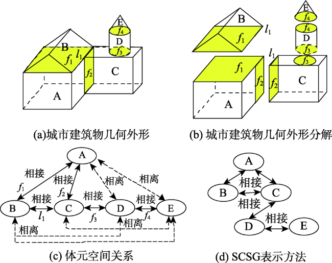
Fig. 1 The description of SCSG representation

图1 SCSG表示的描述

图1所示,图1(a)为复杂的城市建筑物几何形体,图1(b)为城市建筑物几何外形的分解图。从任一个简单体元(假设为A)出发,分析与之有空间关系的体元(B和C,A和B相接于面f1,A和C相接于面f2),形成空间拓扑关系;然后从(B或者C)判断与剩下简单体元的空间拓扑关系,以此类推,和B有空间关系的其余体元为C,B和C相接于l1;与C有空间关系的体元D相接于f3;与D有空间关系的E相接于f4;判断结束后形成体元间的空间关系,确定构成复杂三维形体的体元间的关系图(图1(c)),最后形成对应的SCSG图(图1(d)),确定三维形体的基本形状。
SCSG方法确定了复杂城市建筑物唯一的形状,但不能具体表现出空间要素:点、线、面和体之间的拓扑关系,因此,本文使用边界表示方法(BR)来对城市三维建筑物的要素进行描述。城市建筑物的边界表示法是通过点、边、环、面来表示,它利用多个封闭曲面或多边形围合成对象实体,多个点聚合成边,多条边组合成环,多个环闭合形成曲面。然后,进行要素之间的逻辑关联和拓扑关联,最后BR通过正则布尔运算以及逻辑计算将单元面要素有机地连接在一起,构成地理实体空间数据模型。城市三维建筑物模型的外部使用SCSG树来存储体元,在模型的内部用BR表示法来表示边和点的详细信息,即相当于给SCSG树添加边和点的信息。在混合模型中,对模型起决定性作用的是SCSG结构,BR结构作为辅助表示方法;这种方法减少了建模过程的时间和复杂度,可以详细地表示建筑物模型的几何、拓扑等信息。

2.2 城市建筑物的数据组织方法

本文根据SCSG-BR对复杂城市建筑物的建模方法,添加对城市建筑物墙面纹理和顶面纹理的表示。城市建筑物模型数据包含空间数据和属性数据。建筑物空间数据模型中每个建筑实体都可细分为几何元素、三维对象和体元。建筑物的三维点、线、面和体通过BR表示形成BR模型。几何元素连接属性信息后成为三维对象;三维对象之间存在严格拓扑关系,多个三维对象构成体元,多个简单建筑体元构成复杂建筑体元。建筑物体元之间通过拓扑关系判断体元之间空间关系,生成SCSG模型。两种模型结合形成SCSG-BR模型。属性数据包含空间元素的属性信息表和栅格图像纹理信息,属性表附加给元素后生成含有拓扑关系的三维对象;栅格影像纹理信息附加给平面元素,相当于纹理信息作为面元素的一个属性数据。具体如图2所示。
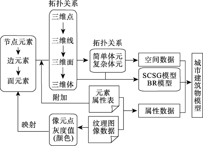
Fig. 2 The data organization of urban building model

图2 城市建筑物模型的数据组织

2.3 城市建筑物数据存储方法

Xie等[20]设计与实现了GIS中的属性数据库管理系统(ADMS),将ADMS设计成文件管理,特征类型设置,数据库操作,表格输出,统计分析,数据库转换和帮助等功能模块,并且特征标识符(ID)被设计用于图形数据和属性数据之间的连接。本文参考ADMS的设计,利用基于文件和关系数据库的联合管理方式来管理所有的建筑物模型信息。关系数据库,用于存储建筑物模型和纹理的属性信息,由各个表单组成,各表单之间根据ID设置关系;文件数据库,包含了模型文件和纹理图像文件,存储建筑物模型、顶面纹理图像和墙面纹理图像。数据的存储方式如图3所示。
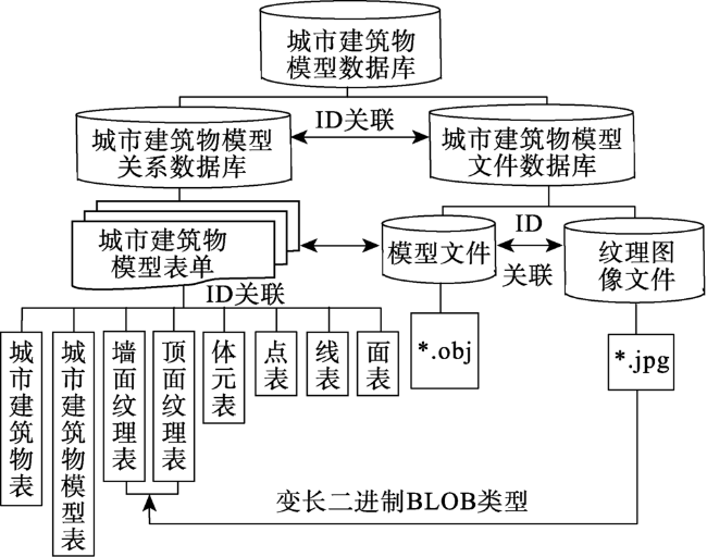
Fig. 3 The storage method of urban buildings

图3 城市建筑物数据存储方法

图3所示,数据表包含3D城市建筑物模型表、点表、线表、面表、体元表、墙面纹理表和顶面纹理表,各表之间通过设置ID进行关联;文件数据为模型文件和纹理图像文件,用于存储生成的建筑物模型和采集的纹理图像。建筑物模型以OBJ格式存储。纹理图像数据包含了墙面纹理和顶面纹理的栅格影像数据,统一保存为JPG格式。纹理数据以变长二进制数据类型存储,即OBLOB字段类型存储于关系数据库中的纹理表单中,一个图像纹理可以存储于一条记录中。
具体的表单设计,纹理调用和存储过程如图4所示,纹理图像是以OBLOB类型存于墙面纹理和顶面纹理的表中。墙面纹理与顶面纹理的ID与建筑物模型中的面表有ID关联的关系,相当于墙面纹理与顶面纹理是面表中的一个属性。当建筑物模型即建筑物SCSG-BR模型加载时,纹理作为面的属性也被加载。通俗的说,纹理数据已经作为建筑物模型的一个属性存储于建筑物模型中;而传统纹理调用方式在模型加载时,通过纹理图像的路径调用纹理,而纹理并非存于模型中,这种方法需要耗费一定的时间且占用计算机的内存。城市建筑物模型与纹理加载同时进行的方法目的在于节约模型加载的时间、减轻计算机内存的负担。
Fig. 4 The relationships of urban building models in the relational database

图4 关系数据库中城市建筑物模型的关系

3 实验与结果分析

3.1 数据源

为了体现本文数据表示方法的广泛性,本文选取2个地区的城市建筑物数据进行实验。这些地区的建筑物密度比较大,建筑结构比较复杂,利用这些数据进行城市建筑物三维建模能够较好地体现本文使用的建模方法。
数据1: 研究区为美国科罗拉多州丹佛地区,将通过DSM(数字表面模型)获得的DBM空间数据作为第1组实验数据,它只包含建筑物的三维信息,包括平面坐标和屋顶的消除信息[21]
数据2: 本文使用ISPRS提供的瑞士苏黎世区域部分DSM和DTM数据作为第2组实验数据,其中包含所有附加信息(2个DSM、1个DTM、建筑物为DXF,DGN和DWG文件,每个切分为对象和像素坐标的6个对象点)。本文使用包含建筑物的DXF、DGN和DWG文件,由CyberCity Modeler制作的测量数据集提供。其中单独的DXF文件包含屋顶模型,这些屋顶模型以线实体表示。
纹理数据:使用Google Earth上截取的影像图片和照相机拍摄的建筑物墙面纹理和顶面纹理图片。本实验选取200张墙面纹理和30张顶面纹理。

3.2 实验过程与结果分析

3.2.1 数据预处理
本文根据得到的点数据,利用BR边界表示法,将点要素转换成线要素,然后将线要素数据转换成面数据,最后在面要素的属性数据中附上高程值。由于苏黎世地区的数据是多面体表示的三维建筑物,能得到的是建筑物的形体而非实体,因此,本文先将数据导出为三维点,然后根据三维点和三维线数据的结合构建建筑物的三维实体。
一般情况下,建筑物的墙体之间都是相互垂直的,但是现实中建筑物底面多边形的内角与实际的直角存在偏差,并且相邻多边形之间可能会存在小部分交叠的不合理情况,导致拓扑不一致的问题。Sugihara等[7]就是因为数据的偏差对建筑物底面进行调整,生成新的正交多边形来生成三维建筑物模型。Gruen等[22]也提出用最小二乘法全自动调整和CAD编辑半自动调整的方法对建筑物数据进行几何正则化,对相邻建筑物进行拓调整。Ledoux等[23]在进行三维建模时,对于有小面积重叠的底面数据运用GRASS进行清理(图5)。本文采用最小二乘法和GRASS软件对数据进行正交化和拓扑调整。
Fig. 5 Topology adjustment of building polygons[23]

图5 建筑物多边形的拓扑调整[23]

根据建筑物正交化和拓扑调整的方法,将数据预处理得到的数据(面数据或者建筑物多边形)进行多边形的正交化和拓扑调整。如图6所示,黑线为原始数据,红线为正交化和拓扑调整后的数据。
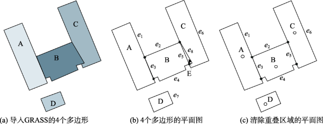
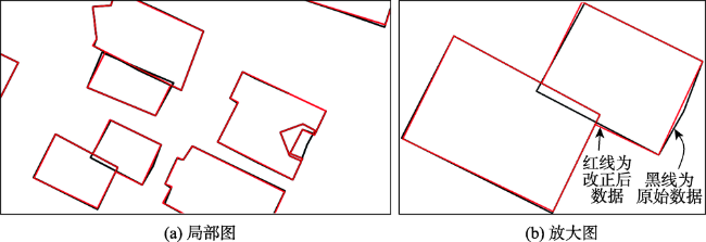
Fig. 6 The result of building polygon orthogonalized and the adjusted building polygon topology

图6 建筑物多边形正交化和拓扑调整

3.2.2 建立建筑物三维模型
建筑物分为简单建筑物和复杂建筑物。简单建筑物可以由简单的体元表示,复杂建筑物由各种简单的体元组合而成。在组合的过程当中,简单体元、复杂体元之间形成拓扑关系,通过布尔运算形成正确形状的复杂建筑物,并使用真实图像作为建筑物的纹理信息附加给模型的面元素,得到具有真实感的城市建筑物模型。
(1)简单建筑物模型的形成过程
由简单建筑物的轮廓线可以看出建筑物的基本形状,包括平屋顶、单屋脊、多屋脊的简单建筑物,模型可以根据底面数据和高度数据进行面的拉伸得到,也可以根据建筑物底面、各个立面和屋顶面一起构成的封闭空间造型成SCSG表示的简单体元,形成的简单建筑物模型和原始的轮廓形状一致;最后附上纹理图像,形成具有真实感的城市建筑物模型(图7)。
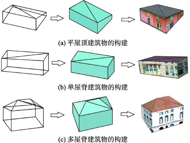
Fig. 7 The construction demonstration of simple buildings

图7 简单建筑物的构建

(2)复杂建筑物的形成过程
复杂建筑物可由很多个简单建筑物组合而成。每一个简单建筑物形成之后,根据DE-9IM判断体元之间的空间拓扑关系,然后简单建筑物之间进行正则布尔运算,得到复杂建筑物。因此建筑物的部分边界已经发生简化,建筑物的拓扑关系发生了改变,最后得到SCSG-BR表示的城市建筑模型。
图8(a)所示,复杂的建筑物由3个简单的部分构成,它们两两之间存在着交叠(overlap)的拓扑关系,当线转成面数据,封闭的面形成体元,从而形成了有相交部分的3个简单体元(图8(b))。CSG模型通过DE-9IM判断体元之间的空间拓扑关系并进行布尔运算(并、交、差)形成复杂建筑物模型。复杂建筑物的边界数据已经发生了改变,在拓扑关系判断的过程中,线和面相较于一点、面和面相交于线、体元于体元相交于面,从而形成了新的边界线,构成SCSG-BR模型(图8(c)),最后根据纹理图像ID与建筑物面ID的关系,将建筑物面附加上纹理图像,得到具有真实感的建筑物模型(图8(d))。同时,体元之间的关系也可看作是相接(Touch)的关系。依此类推,形成了多种复杂形状的建筑物(图9)。
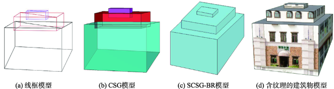
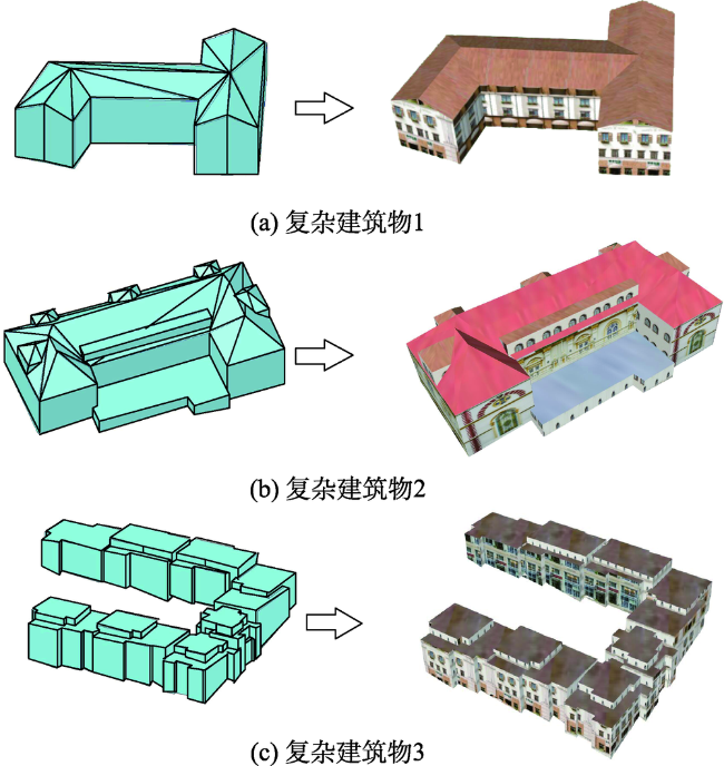
Fig. 8 Formation of the complicated buildings

图8 复杂建筑物的形成

Fig. 9 Modelling the complicated buildings

图9 复杂建筑物建模

根据简单建筑物模型和复杂建筑物模型的形成原理,本实验得到美国科罗拉多州丹佛地区和苏黎世部分建筑物的建筑物模型(图10)。
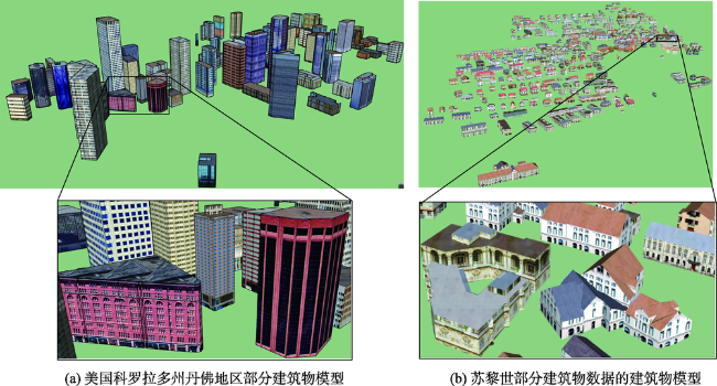
Fig. 10 Three-dimensional urban building model represented by SCSG-BR

图10 空间CSG-BR表示的城市三维建筑物模型

3.2.3 实验结果分析
本文以苏黎世部分建筑物模型为例,通过使用几种不同的建模方法(图11)进行建筑物模型的构建,其中模型包含374个建筑物,81个材质纹理。
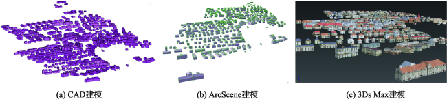
Fig. 11 The comparison analysis of three different types of methods for modeling urban buildings

图11 3种不同城市建筑物建模方法的比较分析

本文利用以上3种不同的建模方法与本文的建模方法,分别对模型加载所耗费的时间进行10次计时统计,最后时间结果取平均值,它们比较的结果如表1所示。从表1可看出,本文的建模方法加载含有纹理的城市建筑物模型平均时间为3.57″; ArcScene建模加载模型平均时间为2.69″,但模型并不包含纹理;CAD建模方法加载模型平均时间为6.33″,且不包含纹理;而3Ds MAX建模方法加载含有纹理的模型平均耗时3.84″。总体来看,本文提出的建模方在加载含有真实纹理的城市建筑物模型时耗时相对较短,表明本文的数据表示方法和纹理调用方式能够使得模型加载的速度得到提高。
Tab. 1 Time-consuming comparisons of four different types of modeling methods

表1 4种不同类型建模方法模型加载耗时比较

建模方法 加载模型耗时 平均耗时 说明
SCSG-BR混合建模方法 3.56″、3.44″、3.68″、3.57″、3.65″、3.6″、3.57″、3.55″、3.61″、3.43″ 3.57″ 包含真实纹理
Arc Scene建模 2.56″、2.40″、2.76″、2.72″、2.69″、2.78″、2.77″、2.76″、2.68″、2.75″ 2.69″ 无纹理
CAD建模 6.48″、6.23″、6.36″、6.38″、6.44″、6.23″、6.27″、6.28″、6.24″、6.38″ 6.33″ 无纹理
3Ds MAX建模 3.92″、3.63″、3.99″、3.77″、4.04″、3.66″、3.71″、3.70″、3.93″、4.06″ 3.84″ 包含真实纹理
城市建筑物模型生成过程中,结合2.2节的城市建筑物模型的数据组织方法,在三维建筑物模型的外形使用SCSG树来存储体元,从而正确的表示建筑物外形,并且根据体元之间的空间拓扑关系快速的确定唯一的SCSG树,减少体元遍历的次数,减少建模时间;在内部采用BR表示法来表示边和点的详细信息,能够弥补SCSG不能表示内部拓扑关系的不足,且含有纹理的BR表示方法将纹理当作是面元素的属性信息,改变传统调用纹理图片的方式。 SCSG和含有纹理的BR表示方法相互结合,取长补短,快速建成具有真实感的城市建筑物3D模型。

4 结论

近10年,学者们对3D城市建筑物的建模研究方面遇到的瓶颈,原因就在于建模偏向于美观而缺少了精度与效率。现阶段的三维建模看上去非常逼真,但在真正量测时会发现,模型中的数据和显示的数据误差很大,导致数据分析和决策依据不可靠。因此,本文采用前人提出的最小二乘算法对建筑物多边形进行正交化,对数据进行拓扑调整,改善由于测量误差带来的影响。同时,本文提出基于纹理和SCSG-BR对城市建筑物的混合建模方法,不仅可以精确地表示规则实体的拓扑关系,并且将纹理看作是墙面和顶面的属性数据,存储在模型中。最后,本文利用基于文件方式和基于关系数据库方式的联合管理方式来管理三维建筑物模型,改变了传统方法在调用纹理图像时的复杂过程,提高模型加载的速度。
本文采用的最小二乘算法对建筑物多边形进行正交化,达到了多边形正交化的目的,但是其约束条件还不够完善,角度的约束并不能包含特殊的角度在内,可能会存在一定误差,因此若是有更多的约束条件来进行正交化,得到的结果会更加精确,这也是今后研究方向。

The authors have declared that no competing interests exist.

[1]
Gruen A, Wang X.CC-Modeler: A topology generator for 3-D city models[J]. ISPRS Journal of Photogrammetry and Remote Sensing, 1998,53(5):286-295.ABSTRACT In this paper, we introduce a semi-automated topology generator for 3-D objects, CC-Modeler (CyberCity Modeler). Given the data as point clouds measured on Analytical Plotters or Digital Stations, we present a new method for fitting planar structures to the measured sets of point clouds. While this topology generator has been originally designed to model buildings, it can also be used for other objects, which may be approximated by polyhedron surfaces. We have used it so far for roads, rivers, parking lots, ships, etc. The CC-Modeler is a generic topology generator. The problem of fitting planar faces to point clouds is treated as a Consistent Labelling problem, which is solved by probabilistic relaxation. Once the faces are defined and the related points are determined, we apply a simultaneous least-squares adjustment in order to fit the faces jointly to the given measurements in an optimal way. We first present the processing flow of the CC-Modeler. Then, the algorithm of structuring the 3-D point data is outlined. Finally, we show the results of several data sets that have been produced with the CC-Modeler.

DOI

[2]
Mathias M, Martinovic A, Weissenberg J, et al.Procedural 3D building reconstruction using shape grammars and detectors[C]// International Conference on 3d Imaging, Modeling, Processing, Visualization and Transmission. IEEE, 2011:304-311.

[3]
Mao B, Ban Y, Harrie L.A multiple representation data structure for dynamic visualization of generalized 3D city models[J]. ISPRS Journal of Photogrammetry & Remote Sensing, 2011,66(2):198-208.In this paper, a novel multiple representation data structure for dynamic visualisation of 3D city models, called CityTree, is proposed. To create a CityTree, the ground plans of the buildings are generated and simplified. Then, the buildings are divided into clusters by the road network and one CityTree is created for each cluster. The leaf nodes of the CityTree represent the original 3D objects of each building, and the intermediate nodes represent groups of close buildings. By utilising CityTree, it is possible to have dynamic zoom functionality in real time. The CityTree methodology is implemented in a framework where the original city model is stored in CityGML and the CityTree is stored as X3D scenes. A case study confirms the applicability of the CityTree for dynamic visualisation of 3D city models.

DOI

[4]
Sugihara K.Knowledge-based automatic generation of 3D building models from building footprint by straight skeleton computation[J]. International Journal of Knowledge and Web Intelligence, 2012,3(4):361-371.Abstract 3D urban models are important in several fields, such as urban planning and gaming industries. However, enormous time and labour has to be consumed to create these 3D models. In order to automate laborious steps, a GIS and CG integrated system was proposed for automatically generating 3D building models, based on building polygons (building footprints) on digital maps. For either orthogonal or non-orthogonal building polygons, the knowledge-based system is proposed for automatically generating 3D building models with general shaped roofs by straight skeleton computation. In this paper, the algorithm for 'split event' is clarified and the new methodology is presented for constructing roof models by assuming the third event: 'simultaneous event' and, at the end of the shrinking process, some polygons are converged to 'a line of convergence'.

DOI

[5]
Baig S U, Rahman A A.A three-step strategy for generalization of 3D building models based on CityGML specifications[J]. Geojournal, 2013,78(6):1013-1020.3D building models of the world exhibit multi-scale properties. Different level-of-details (LoDs) are important for different applications. Therefore, generation of multi-scale representation of 3D building models to fulfill the demands of these applications is a generalization problem. In order to generalize 3D buildings, different pieces of information need to be preserved or removed to restrict the amount of data represented on a certain LoD. In this work, a three-step strategy based on simplification, aggregation and reconstruction of generalized buildings represented in City Geography Markup Language (CityGML) is proposed. The minimum length of edges (threshold value) for removal of amount of data is restricted to generalization specifications of CityGML characterized by differing accuracies and minimal dimensions of objects for each LoD. The main part of this paper is simplification of ground plans. For this purpose, a new approach is proposed to restrict number of edges, curves, and corners of ground plan of 3D building model on a certain LoD. Algorithms for simplification with the aim to derive LoD1 from exterior shells of buildings at LoD3 are implemented and tested on a number of buildings of Putrajaya city. The experiments showed that length of edge as threshold value is directly proportional to the size of generalized models.

DOI

[6]
Sasaki N, Chen H T, Sakamoto D, et al.Facetons: Face primitives for building 3D architectural models in virtual environments[C]//ACM Symposium on Virtual Reality Software and Technology. ACM, 2013:77-82.

[7]
Sugihara K, Zhou X, Shen Z.Automatic generation of 3D building models by rectification of building polygons[J]. Advanced Science Letters, 2015,21(12):3649-3654.A 3D city model is important in urban planning and game industries. But, enormous time and labour has to be consumed to create these 3D models. In order to automate laborious steps, a GIS (Geographic Information System) and CG integrated system is proposed for automatically generating 3D building models, based on building polygons on a digital map. Since technicians are drawing these polygons manually with digitizers, depending on aerial photos, not all building polygons are precisely orthogonal. However, creating 3D building models are expected to be orthogonal. When placing a set of boxes as building bodies for creating the buildings, there may be gaps or overlaps between these boxes if building polygons are not precisely orthogonal. In this paper, the new methodology is proposed for rectifying the shape of building polygons and generating 3D building models without any gap and overlap.

DOI

[8]
王继水,顾卫杰.一种单体建筑物的三维混合建模方法[C]//International Conference on Future Information Technology and Management Engineering. IEEE, 2010:326-329.

[ Wang J S, Gu W J.A three-dimensional hybrid modeling method of single building[C]//International Conference on Future Information Technology and Management Engineering. IEEE, 2010:326-329. ]

[9]
Zhou G, Song C, Simmers J, et al.Urban 3D GIS From LiDAR and digital aerial images[J]. Computers & Geosciences, 2004,30(4):345-353.This paper presents a method, which integrates image knowledge and ght etection nd anging (LiDAR) point cloud data for urban digital terrain model (DTM) and digital building model (DBM) generation. The DBM is an Object-Oriented data structure, in which each building is considered as a building object, i.e., an entity of the building class. The attributes of each building include roof types, polygons of the roof surfaces, height, parameters describing the roof surfaces, and the LiDAR point array within the roof surfaces. Each polygon represents a roof surface of building. This type of data structure is flexible for adding other building attributes in future, such as texture information and wall information. Using image knowledge extracted, we developed a new method of interpolating LiDAR raw data into grid digital surface model (DSM) with considering the steep discontinuities of buildings. In this interpolation method, the LiDAR data points, which are located in the polygon of roof surfaces, first are determined, and then interpolation via planar equation is employed for grid DSM generation. The basic steps of our research are: (1) edge detection by digital image processing algorithms; (2) complete extraction of the building roof edges by digital image processing and human omputer interactive operation; (3) establishment of DBM; (4) generation of DTM by removing surface objects. Finally, we implement the above functions by MS VC++ programming. The outcome of urban 3D DSM, DTM and DBM is exported into urban database for urban 3D GIS.

DOI

[10]
Zhou G, Tan Z, Cen M, et al.Customizing visualization in three-dimensional urban GIS via web-based interaction[J]. Journal of Urban Planning & Development, 2006,132(2):97-103.This paper presents our research results of visualizing three imensional (3D) city models in a web explorer environment under the supports of the digital building model, the digital terrain model, large-scale true urban orthoimage, and actual building sidewall pictures. A system has been designed and developed under a client/server architecture, which integrates the Internet Geographic Information System with multitier web applications for creation of a 3D city model. The front-end client provides a user interface for setting the properties of the 3D city model, and the back-end server processes these parameters and generates a 3D model, which is then sent back to the Virtual Reality Modeling Language nabled World Wide Web browser for display and navigation. The technology for display and navigation of the 3D model is implemented using Java Server Pages/Servlet technology built under multitier web architecture. The technology for data accessing and processing is implemented through Java programming language. The displayer is linked to the database, where the required GIS spatial data are stored. The results from our experiments demonstrated that this developed system is able to display and visualize 3D city data in a web environment for public accesses. Using the sidewall pictures taken from real city buildings, we refill the white walls of urban buildings into a real appearance as seen in our real world cities. The player provides several click buttons to enhance the effect and position of visualization, including rotation, zoom, pan, seek, etc. The users can easily view the details of a specified building or/and the entire city in a moving 3D manner, and locate a specific building.

DOI

[11]
Zhou G, Zhou X.Seamless fusion of LiDAR and aerial imagery for building extraction[J]. IEEE Transactions on Geoscience and Remote Sensing, 2014,52(11):7393-7407.Although many efforts have been made on the fusion of Light Detection and Ranging (LiDAR) and aerial imagery for the extraction of houses, little research on taking advantage of a building's geometric features, properties, and structures for assisting the further fusion of the two types of data has been made. For this reason, this paper develops a seamless fusion between LiDAR and aerial imagery on the basis of aspect graphs, which utilize the features of houses, such as geometry, structures, and shapes. First, 3-D primitives, standing for houses, are chosen, and their projections are represented by the aspects. A hierarchical aspect graph is then constructed using aerial image processing in combination with the results of LiDAR data processing. In the aspect graph, the note represents the face aspect and the arc is described by attributes obtained by the formulated coding regulations, and the coregistration between the aspect and LiDAR data is implemented. As a consequence, the aspects and/or the aspect graph are interpreted for the extraction of houses, and then the houses are fitted using a planar equation for creating a digital building model (DBM). The experimental field, which is located in Wytheville, VA, is used to evaluate the proposed method. The experimental results demonstrated that the proposed method is capable of effectively extracting houses at a successful rate of 93%, as compared with another method, which is 82% effective when LiDAR spacing is approximately 7.3 by 7.3 ft2. The accuracy of 3-D DBM is higher than the method using only single LiDAR data.

DOI

[12]
Egenhofer M J, Franzosa R D.Point set topological spatial relations[J]. International Journal of Geographic Information systems, 1991,5(2):161-174.Practical needs in geographic information systems (GIS) have led to the investigation of formal and sound methods of describing spatial relations. After an introduction to the basic ideas and notions of topology, a novel theory of topological spatial relations between sets is developed in which the relations are defined in terms of the intersections of the boundaries and interiors of two sets. By considering empty and non-empty as the values of the intersections, a total of sixteen topological spatial relations is described, each of which can be realized in R2. This set is reduced to nine relations if the sets are restricted to spatial regions, a fairly broad class of subsets of a connected topological space with an application to GIS. It is shown that these relations correspond to some of the standard set theoretical and topological spatial relations between sets such as equality, disjointness and containment in the interior.

DOI

[13]
Egenhofer M J, Shama J, Mark D M.A critical comparison of the 4-intersection and 9-intersection models for spatial relationship: Formal analysis[C]//McMaster and M. Armstrong (EDS), Auto-Cartoll, California: American Congress on Surveying and Mapping, 1993:1-12.

[14]
Egenhofer, M J.Deriving the composition of binary topological relations[J]. Journal of Visual Languages and Computing, 1994,5(2):133-149.A new formalism is presented to derive knowledge about the composition of two binary topological relations over a common object. The formalism is based on a topological data model and compares the nine empty and non-empty intersections of interiors, boundaries and exteriors between two objects. Based upon the transitivity of set inclusion, the intersections of the composed topological relations are derived. These intersections are then matched with the intersections of the eight fundamental topological relations, giving an interpretation to the composition of topological relations. The result of this study is the composition table of the eight binary topological relations that exist between n -dimensional point sets with a co-dimension of 0. While the combined topological relations are unique for some compositions, more than half of all possible compositions are disjunctions of possible relations. Geometric prototypes are shown for the two-dimensional case. The composition table enables topological reasoning at the conceptual level of relations, rather than having to calculate all relations from the representation of the spatial objects. Its practical value is that it can serve as in a computational model for an assessment of whether a set of topological predicates is consistent or not and in spatial query processing when no explicit information about spatial relations is available.

DOI

[15]
李成名,陈军.空间关系描述9-交模型的改进[J].武汉测绘科技大学学报,1997,22(3):207-211.

[ Li C M, Chen J.Description of spatial relationships 9-Improvement of delivery model[J]. Journal of Wuhan University of Surveying and Mapping, 1997,22(3):207-211. ]

[16]
Hmida H B, Boochs F, Cruz C, et al.From quantitative spatial operator to qualitative spatial relation using constructive solid geometry, logic rules and optimized 9-IM model: A semantic based approach[C]//Computer Science and Automation Engineering (CSAE), 2012:453-458.

[17]
Zhang J, Qin X.Topological analysis between bodies with holes[J]. International Journal of Computer Science and Network Security, 2008,8(5):167-174.ABSTRACT Summary The topological relation is one of the most important spatial relations. Analysis of spatial relation has great practical value. The possible topological relations between 3D simple body objects can be analyzed using 9-intersection model. An algorithm is proposed to analyze the topological relations between body objects. It decomposes the complicated objects into simple objects, so it can get the topological relations between complicated body objects such as bodies with holes efficiently.

[18]
Clementini E, Felice P D.A model for representing topological relationships between complex geometric features in spatial databases[J]. Information Sciences, 1996,90(1):121-136.Various models for the representation of topological relationships have been developed. The aim of this paper is to show that the set of relationships proposed in (the CBM), for describing topological relationships among two-dimensional simple features, is applicable with few modifications to the case of complex features (that is, areas made up of several components possibly containing holes, lines with self-intersections, and/or more than two endpoints, and so on). The CBM offers a small set of topological relationships with high expressiveness which is proven to be mutually exclusive and complete, and therefore suitable to be embedded in a spatial query language.

DOI

[19]
Shen J, Wen Y, Guo-nian L, et al. Calculation of topological relationships between bodies[J]. Science of Surveying and Mapping, 2012,37(4):120-125.

[20]
Xie M, Zhou G, Li D, et al.Design and implementation of attribute database management system in A GIS: GeoStar[J]. International Journal of Geographic Information Science, 2000,6(2):170-180.This paper presents the design and implementation of an attribute database management system (ADMS) in a Geographic Information System (GIS) system called GeoStar, which has been developed by the center for GIS at Wuhan Technical University of Surveying and Mapping (WTUSM) in China.

DOI

[21]
Zhou G, Chen W, Kelmelis J A, et al.A comprehensive study on urban true orthorectification[J]. IEEE Transactions on Geoscience & Remote Sensing, 2005,43(9):2138-2147.To provide some advanced technical bases (algorithms and procedures) and experience needed for national large-scale digital orthophoto generation and revision of the Standards for National Large-Scale City Digital Orthophoto in the National Digital Orthophoto Program (NDOP), this paper presents a comprehensive study on theories, algorithms, and methods of large-scale urban orthoimage generation. The procedures of orthorectification for digital terrain model (DTM)-based and digital building model (DBM)-based orthoimage generation and their mergence for true orthoimage generation are discussed in detail. A method of compensating for building occlusions using photogrammetric geometry is developed. The data structure needed to model urban buildings for accurately generating urban orthoimages is presented. Shadow detection and removal, the optimization of seamline for automatic mosaic, and the radiometric balance of neighbor images are discussed. Street visibility analysis, including the relationship between flight height, building height, street width, and relative location of the street to the imaging center, is analyzed for complete true orthoimage generation. The experimental results demonstrated that our method can effectively and correctly orthorectify the displacements caused by terrain and buildings in urban large-scale aerial images.

DOI

[22]
Gruen A, Wang X.News from CyberCity-Modeler[J]. Publishers Proceedings of the Monte Verita Workshop, 2001.ABSTRACT Semi-automated object extraction has become a viable concept for the generation of 3-D city models. CyberCity-Modeler (CCM) has been developed with the aim of creating not only buildings, but also other objects pertaining to a city model efficiently and with a high degree of flexibility concerning the level of detail. In its commercial implementation, CCM has been confronted with a number of user requirements which needed to be observed. This led to some extensions in functionality, which are addressed in this paper: Geometrical regularization of buildings, editing functions for topology adjustment, integration of faades and other vertical walls and modeling of roof overhangs. These extensions of the original concept make CyberCity-Modeler an even more powerful tool for 3-D city modeling.

[23]
Ledoux H, Meijers M.Topologically consistent 3D city models obtained by extrusion[J]. International Journal of Geographical Information Science, 2011,25(4):557-574.One of the simplest methods to construct a 3D city model is to extrude building footprints to obtain ‘block-shaped’ polyhedra representing buildings. Although the method is well known and easy to implement, if the 2D topological relationships between the footprints are not taken into account, the resulting 3D city models will not necessarily be topologically consistent (i.e. primitives shared by 3D buildings will be duplicated and/or intersect each others). As a result, the model will be of little use for most applications, besides visualization that is. In this article, we present a new extrusion procedure to construct topologically consistent 3D city models. It is based on the use of a constrained triangulation, is conceptually simple and offers great flexibility to create city models in different formats (e.g. CityGML or a surface-based representation). We have implemented the procedure, tested it with real-world data sets and validated it.

DOI

文章导航

/