
大规模航运数据下“一带一路”国家和地区贸易网络分析
作者简介:孙涛(1993-),男,博士生,主要从事时空数据挖掘研究。E-mail: suntao@ict.ac.cn
网络出版日期: 2018-05-20
基金资助
中国科学院重点部署项目(ZDRW-ZS-2016-6)
Analysis on the Trade Networks of the Belt and Road Countries and Regions under Large Scale Shipping Data
Online published: 2018-05-20
Supported by
Key Project of the Chinese Academy of Sciences,No.ZDRW-ZS-2016-6.
Copyright
在“一带一路”沿线的65个国家中,46个国家拥有登记在案的港口,同时海上航运贸易占国际贸易总量的75%以上。为了充分了解“一带一路”沿线国家和地区航运贸易情况,评估国家、区域之间贸易往来关系,本文选取了2016年“一带一路”国家和地区船舶历史运动轨迹,首先基于规则判定的方法挖掘船舶停港事件,并以港口为主要节点,港口间货运往来事件为连接形成“一带一路”国际航运贸易网络。在此基础上,对贸易网络进行如下网络结构分析:① “一带一路”贸易网络基本属性统计,包括网络连通性、度分布、平均最短路径;② 网络节点中心度计算,主要采用Eigenvector Centrality评估分析贸易网中节点中心度;③ 结合社会网络挖掘中社区挖掘的概念,使用Fast Unfolding算法对贸易网络进行社区发现。可以看出,“一带一路”沿线国家和地区贸易往来错综复杂,港口之间呈现小世界网络特性;土耳其、俄罗斯、中国等国的港口影响力靠前;并且形成五大贸易社区,这些社区的分布和地理位置分布基本吻合,但仍然有部分国家受特殊贸易行为的影响,所属社区有所打破区域限制。本文旨在通过航运大数据构建贸易网络,在网络分析基础上,更好地评价节点影响力,更清晰地分析贸易网络结构,为“一带一路”战略更好地实施提供帮助。
孙涛 , 吴琳 , 王飞 , 王琪 , 陈昭 , 徐勇军 . 大规模航运数据下“一带一路”国家和地区贸易网络分析[J]. 地球信息科学学报, 2018 , 20(5) : 593 -601 . DOI: 10.12082/dqxxkx.2018.180066
Among the 65 countries along the Belt and Road, 46 countries have registered ports of entry. At the same time, the trade by maritime shipping account for more than 75% of the total international trade. In order to fully understand the shipping trade in the countries and regions along the Belt and Road and assess the trade relations between countries and regions along the Belt and Road, we selected data which depicts the shipping history movements of the countries along the Belt and Road in the year of 2016 for study in this paper. Firstly, based on the method of rule determination, we excavated the Stop-port events of ships. By use of the ports in the countries of the Belt and Road as the main nodes, and the inter-port cargo transactions events as the edges, we have built the Belt and Road international shipping trade network. Based on this, the following network structure analyses of trade networks were conducted: (1) basic attributes analysis of the Belt and Road trade network, including network connectivity, degree distribution and average shortest path; (2) calculation of network node centrality, mainly using Eigenvector Centrality to evaluate the centrality of nodes in the trade network; (3) Using the concept of community mining in social network mining as the reference, and using the Fast Unfolding algorithm to discover the community of trading network. It can be seen that the trade between the countries and regions along the Belt and Road is intricately interwoven. By analyzing the degree distribution of nodes in the trade network, it can be clearly seen that there are small-world networks within the Belt and Road trade network. Further, Turkey, Russia and China are the three most influential counties in terms of the ports influence. By analyzing the results of the community detection, five major trade communities were identified. The distribution of these communities is basically in line with the geographical distribution. However, there are still some countries that are affected by special trade practices and their communities have broken regional restrictions. By building the trading network under large scale ship data, we evaluated the node's influence and analyzed the structure of the trade network more clearly on the basis of network analysis, and we hope this paper can help to better implement the Belt and Road Initiative strategy.
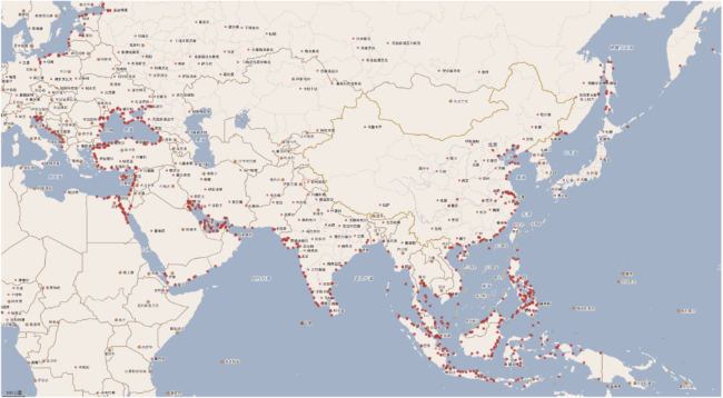
Fig. 1 Distribution of ports of the Belt and Road countries and regions图1 “一带一路”国家和区域港口分布 |
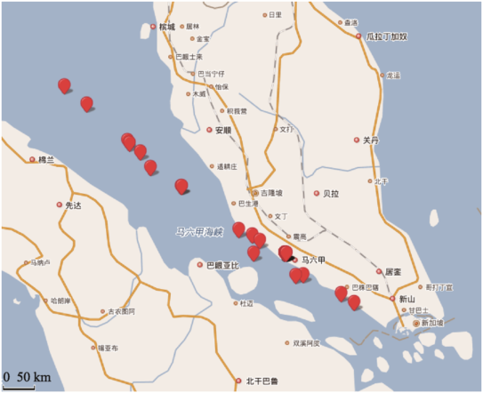
Fig. 2 A schematic diagram of a ship's trajectory图2 船舶轨迹示意图 |
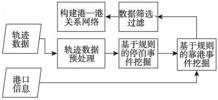
Fig. 3 Trade network building process based on shipping data图3 基于航运数据的贸易网络搭建流程 |
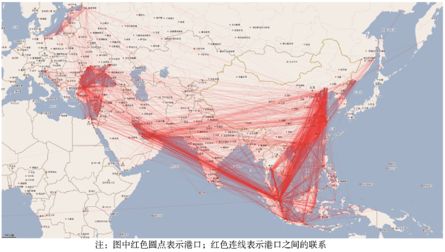
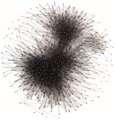
Fig. 4 The Belt and Road trade network图4 “一带一路”贸易网络 |
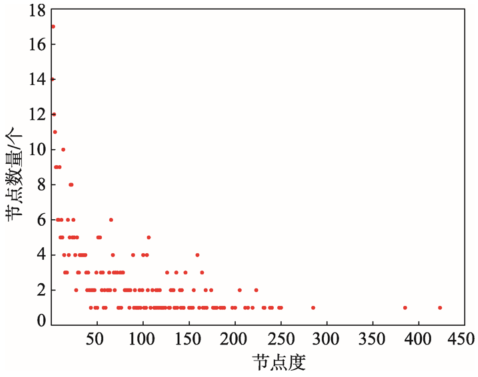
Fig. 5 Node degree distribution of the Belt and Road trade network图5 “一带一路”贸易网络节点度分布 |
Tab. 1 Top 10 centrality port表1 贸易网络中心度排名前10的港口 |
| 序号 | 港口名称 | 所属国家 | 中心度 |
|---|---|---|---|
| 1 | NINGBO-ZHOUSHAN | 中国 | 1.000000 |
| 2 | KEPPEL | 新加坡 | 0.699081 |
| 3 | JURONG ISLAND | 新加坡 | 0.655534 |
| 4 | PULAU BUKOM | 新加坡 | 0.555983 |
| 5 | RIZHAO | 中国 | 0.525089 |
| 6 | TANJUNG PELEPAS | 马来西亚 | 0.513386 |
| 7 | HUANGPU | 中国 | 0.505709 |
| 8 | PORT KLANG | 马来西亚 | 0.497864 |
| 9 | TIANJIN XIN GAGN | 中国 | 0.497709 |
| 10 | TAICANG | 中国 | 0.497351 |
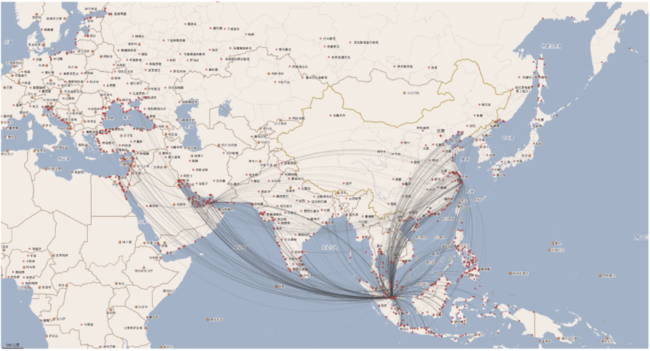
Fig. 6 "The Belt and Road" main trade route图6 “一带一路”主贸易干线 |
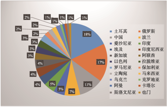
Fig. 7 The top 100 port countries of the trade community network center图7 贸易社区网络中心度排名前100的港口国家分布 |
Fig. 8 The distribution of the trade network community with the port as the node图8 以港口为节点的贸易网络社区分布 |
Fig. 9 The division of the trade network community with the port as the node图9 以港口为节点的贸易网络社区划分 |
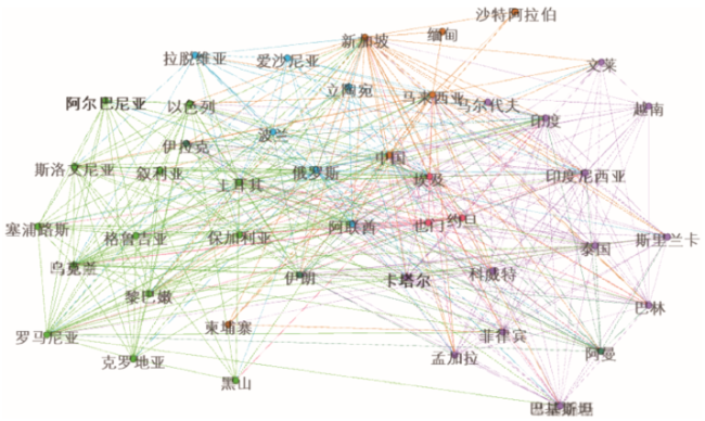
Fig. 10 The division of the trade network community with the state as the node图10 以国家为节点的贸易网络社区划分 |
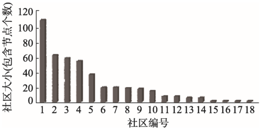
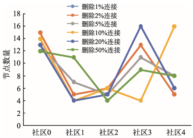
Fig. 11 The number of nodes of the trade network community under different disturbances图11 不同扰动下贸易网络社区包含节点数量对比 |
The authors have declared that no competing interests exist.
| [1] |
World Port Source. World Port Index[EB/OL]. , 2017-12-31.
|
| [2] |
[ He C F, Xu T, Hu Q Y, et al. Ship AIS data acquisition using the Beidou satellite navigation system[J]. Journal of Shanghai Maritime University, 2013,34(1):5-9. ]
|
| [3] |
[
|
| [4] |
[
|
| [5] |
[
|
| [6] |
船讯网[EB/OL]. .
[ Myships. [EB/OL] ,2017-12-31. ]
|
| [7] |
https://www.marinetraffic.com/en/ais/home/centerx:-12.0/centery:25.0/zoom:42017-12-31
|
| [8] |
[shipxy [EB/OL] ,2017-12-31.]
|
| [9] |
[
|
| [10] |
Handbook of multisensor data fusion: Theory and practice[M]. Boca Raton: CRC press, 2017.
|
| [11] |
Trajectory Data Mining: An Overview. ACM TIST 6(3): 29:1-29:41(2015).
|
| [12] |
[
|
| [13] |
|
| [14] |
|
| [15] |
[
|
| [16] |
[
|
| [17] |
[
|
| [18] |
|
| [19] |
[
|
| [20] |
[
|
| [21] |
|
| [22] |
|
| [23] |
维基百科. 马六甲海峡[EB/OL]. .
[ Wikipedia, Malacca. [EB/OL]..2017-12-31. https://en.wikipedia.org/wiki/Strait_of_Malacca]
|
/
| 〈 |
|
〉 |