2017年中国地理信息科学理论与方法学术年会优秀论文专辑

城市空间结构要素与人群聚散稳定性的关联性探索

  • 杨喜平 , 1, 2 ,
  • 方志祥 , 3, * ,
  • 尹凌 4
展开
  • 1. 陕西师范大学地理科学与旅游学院,西安 710119
  • 2. 陕西省旅游信息科学重点实验室,西安 710119
  • 3. 武汉大学测绘遥感信息工程国家重点实验室,武汉 430079
  • 4. 中国科学院深圳先进技术研究院,深圳 518055
*通讯作者:方志祥(1977-),男,博士,教授,主要从事时空GIS与行人智慧导航研究。E-mail:

作者简介:杨喜平(1986-),男,博士,讲师,主要从事时空轨迹大数据挖掘与人群移动行为研究。E-mail:

收稿日期: 2018-01-02

  要求修回日期: 2018-03-19

  网络出版日期: 2018-06-20

基金资助

国家重点研发计划项目(2017YFC1405302, 2017YFB0503802)

国家自然科学基金项目(41771473、41231171、41771441、41571135)

中国博士后科学基金项目(2017M623112、2018M632860)

中央高校基本科研业务费资助项目(GK201803049、2042017kf0235)

Exploring the Relationship between Urban Spatial Structure and the Stability of Human Convergence-divergence

  • YANG Xiping , 1, 2 ,
  • FANG Zhixiang , 3, * ,
  • YIN Ling 4
Expand
  • 1. School of Geography and Tourism, Shaanxi Normal University, Xi'an 710119, China
  • 2. Shaanxi Key Laboratory of Tourism Informatics, Xi'an 710119, China
  • 3. State Key Laboratory of Information Engineering in Surveying, Mapping and Remote Sensing, Wuhan University, Wuhan 430079, China
  • 4. Shenzhen Institutes of Advanced Technology, Chinese Academy of Sciences, Shenzhen 518055, China
*Corresponding author: FANG Zhixiang, E-mail:

Received date: 2018-01-02

  Request revised date: 2018-03-19

  Online published: 2018-06-20

Supported by

National Key Research and Development Program of China, No.2017YFC1405302, 2017YFB0503802

National Natural Science Foundation of China, No.41771473, 41231171, 41771441, 41571135

China Postdoctoral Science Foundation, No.2017M623112, 2018M632860

Fundamental Research Funds for the Central Universities, No.GK201803049, 2042017kf0235

Copyright

《地球信息科学学报》编辑部 所有

摘要

人群移动和城市空间结构的关系研究一直是人文地理关注的焦点,它可以帮助理解人群城市空间中移动的潜在动力和影响因素,从而评价城市空间结构的合理性,对城市规划、选址具有重要意义。轨迹大数据为研究城市大规模群体活动、城市空间结构以及二者的关系提供了新视角。本文以人群聚散稳定性为切入点,以深圳市交通小区为分析单元,从社会经济属性、土地利用模式和路网中心性3个方面定量探索城市空间结构特征与人群聚散稳定性的关联性。结果发现:区域的人口数量和密度越大,人群聚散稳定性越低;土地利用混合度越高,均衡性越低,人群聚散稳定性越低;与路网全局中心性比,局部范围内的路网中心性对人群聚散稳定性的影响较大,并且随着距离不同而发生变化。这些知识帮助加深理解人群聚散与城市空间结构特征之间的关系。

本文引用格式

杨喜平 , 方志祥 , 尹凌 . 城市空间结构要素与人群聚散稳定性的关联性探索[J]. 地球信息科学学报, 2018 , 20(6) : 791 -798 . DOI: 10.12082/dqxxkx.2018.180026

Abstract

The relationship between human mobility and urban spatial structure has been a long research topic in human geography, which is helpful for understanding the impacts of human mobility and assessing the rationality of urban spatial structure, thus, important and meaningful for urban planning, traffic management, location selection and emergency management. Traditional studies take advantage of travel survey dataset to investigate the relationship between human travel behavior and urban built environment, which makes it difficult to study human convergence and divergence due to the limitation of small sample size. Recently, with the development of Information Communication Technology (ICT), it is possible to collect massive and long-term human spatio-temporal tracing dataset (such as mobile phone data, social media check-in data, floating cars data and so on), which brings a new perspective of studying urban human mobility, spatial structure and their relationship. Based on the previous study, this study focus on the stability of human convergence and divergence, takes traffic analysis zones as spatial analysis unit, aims to explore the correlation between urban spatial structure and the stability of human convergence and divergence. The indicators representing urban structure are constructed from the aspects of socio-economic, land use patterns and urban road network characteristics, respectively. The multiple linear programming is employed to examine the influence of these indicators on the stability of human convergence and divergence. We found that the bigger the population size and density of a place, the less stable the human convergence and divergence. The degree of the mixture of the land use is positively associated with the stability. As for the centrality of road network, the local centrality has significant influence on the stability of human mobility and the impact is different with the increasing of search distance. These knowledges can deepen our understanding of relationship between human mobility and urban spatial structure, which can be utilized by urban operators to guide urban planning, traffic management and make some emergency measures.

1 引言

城市是人群活动与空间结构长期相互作用的结果,城市人群移动行为与空间结构特征密切相关。在时空间行为研究中,学者们采用问卷调查数据从个体的角度研究了城市空间结构特征(如城市基础设施、土地利用模式、可达性等)对人的移动距离、活动空间和通勤模式的影响[1,2,3]。由于调查数据样本量较小,无法对城市大规模群体移动行为进行研究。近来,轨迹大数据帮助学者从群体、动态、时空的角度理解城市人群移动行为和空间结构的关系[4,5,6]。目前大部分研究遵循“数据-人群移动模式-城市空间结构”的研究思路,即从轨迹大数据中挖掘人群移动模式进而识别城市空间结构如城市土地利用特征[7,8]、多中心性交互结构[9,10]和职住空间分布等[11,12],但是对城市空间结构与人群移动行为相互作用关系的研究较少。本研究试图从群体的角度探索城市空间结构要素与人群移动时空行为的关联性,帮助揭露城市人群移动的潜在动力,对于城市的规划、交通管理和政策制定具有重要指导意义。
人群聚散是人群在城市中移动形成的一个普遍但非常重要的现象,与城市空间结构特征密切相关的[13,14]。人群聚散的稳定性反映了一个地方人群突变的程度,潜在反映了该地方对交通需求的稳定性和人群活跃程度。Fang等[15]提出了一种基于轨迹大数据的人群聚散稳定性评价模型,评价了深圳市交通小区、公交站和公交线路覆盖人群的动态稳定性。本文在该研究的基础上进一步探讨城市空间结构与人群聚散稳定性的关系,分析一个地方人群聚散的稳定性是否与该地方的城市空间结构存在关联,以及与城市空间结构中那些要素关联性较大。

2 人群聚散稳定性

图1给出了地方A和地方B的人群随时间聚散变化序列,地方A一天中人群的聚散变化较平稳,而地方B人群聚散变化幅度较大。人群聚散的稳定性帮助衡量人群聚散变化剧烈程度,潜在的反映了该方法交通需求的稳定性。Fang等[15]通过对人群聚散时间序列进行分析,将其分为聚集和消散的交替过程,构建聚集消散过程的稳定性模型,最后建立评价人群聚散序列的稳定性模型,并以手机位置大数据为例,利用模型评价了深圳市各交通小区覆盖人群的聚散稳定性(图2),稳定性值越大表示人群聚散活动越稳定。本文在此基础上进一步探索交通小区空间结构特征与人群聚散稳定性的关联性。
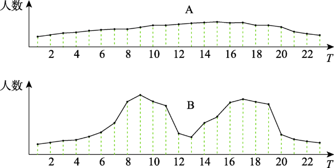
Fig. 1 The time sequence of human convergence and divergence

图1 人群聚散变化序列示意图

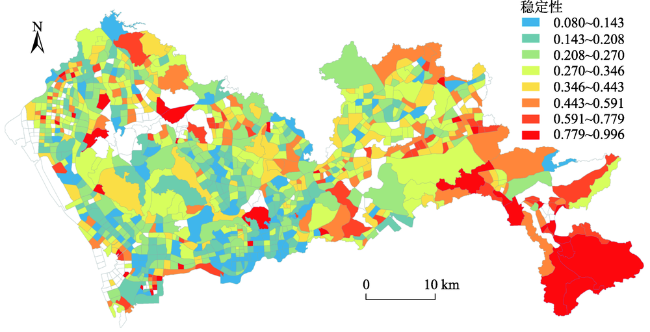
Fig. 2 The stability of Traffic Analysis Zones (TAZs)

图2 深圳市交通小区稳定性[15]
注:空白为没有数据的交通小区

3 城市空间结构要素

城市空间结构是指城市各个要素通过其内在机制的相互作用而形成的相对区位关系和空间形态,是城市社会经济存在和发展的空间形式,也是长期过程中人类空间活动和区位选择的积累结 果[16]。在城市中,一个地方的社会经济属性(如经济发展程度,人口,面积等)会影响人群的移动行 为[17]。土地利用结构是描述城市空间结构的一个重要要素,城市土地功能的空间分布模式决定了人群移动的时空模式和社区的人群活力[14,18]。此外,城市道路网结构特性也是影响人群移动行为的另一个重要因素,路网的拓扑特性和可达性直接反应城市不同空间道路设计的合理性和可达难易程度,在一定程度上影响人群在空间上的出行行为[19]。因此,本研究将从社会经济属性、土地利用结构和路网结构3个方面来构建描述城市空间结构特征的指标,并采用多元线性回归模型定量分析城市空间结构要素与人群聚散稳定性的关联性,加深对二者关系的理解。

3.1 社会经济属性

社会经济属性是指城市人群的社会经济活动所赋予的特性,是可以反映一个区域一些固有特征的属性。本文采用交通小区的人口、面积、人口密度和房价4个解释变量衡量交通小区的社会经济属性。其中,人口 P i 是通过从手机数据中识别城市居民的职住分布获得,房价是从安居客网站(http://shenzhen.anjuke.com/)爬取深圳市范围内所有房屋交易价格(数据获取时间为2013年7月),对于每个交通小区,求取房屋价格的平均值作为该小区的房价 V i

3.2 土地利用结构

土地利用结构是指一个区域内各种功能用地类型的比例及其相互影响、相互作用所形成的空间结构关系。徐萍[20]认为土地利用结构的内涵主要包括4个方面:① 土地利用的组成要素及其性质和特点;② 各要素之间的相互依赖关系,如比例关系;③ 各要素的相互作用;④ 各要素相互关系的发展变化。根据土地利用结构定义及内涵,本文将从土地利用的比例、区位熵、信息熵和均衡度4个方面来构建描述土地利用结构特性的解释变量。本文根据《城市用地分类与规划建设用地标准》,将土地利用划分成6个大类:商业用地(C)、工业用地(I)、居住用地(R)、公共用地(P)、交通用地(T)和其他用地(O),分别计算每个交通小区的土地利用比例、区位熵[21]、信息熵和均衡度。

3.3 路网中心性

在复杂网络理论中,中心性是用来衡量一个节点或边的重要程度,反映了节点或边在网络中的地位。城市道路网的中心性反映节点或边在城市交通运行中的重要性[22],影响城市人群的移动行为。本文采用接近中心性、介数中心性和直达中心性 3个指标来分析路网拓扑结构特性对人群聚散稳定性的影响。接近中心性( C i C )是衡量一个节点与路网中其他所有节点的临近程度,是该节点到路网中其他所有节点的最短路径的和的倒数。介数中心性( C i B )是衡量某一节点在路网中的起中介作用的程度,是路网中任意两个节点的最短路径中经过该节点的最短路径数量。直达中心性( C i S )是衡量网络中节点到其他节点的直线系数,是这2个节点之间的欧氏距离与最短路径距离比值。
在计算路网中心性时,通过计算该节点到路网中其他所有节点的最短路径距离,从全局的角度来搜索路网中其他所有的节点,最终所计算的值为全局中心性值,记为 C g C C g B C g S 。Porta等[23]认为全局中心性会受到边缘地区的影响而出现边界效应,即越靠近城市的边缘地区,全局中心性的值越低,而局部的中心性可以克服这种边界效应。Rui等[24]认为局部中心性可以帮助了解路网在局部尺度的一些特性,能够揭露人群在局部区域水平上的位置选择行为。本文计算了路网的局部中心性,分析路网的局部中心特性对人群聚散稳定性的影响。局部中心性是指在计算中心性时只搜索节点一定距离范围内的节点,超出该距离范围无需计算。本文分别计算了5、10、15、20、25和30 km共6个范围内的局部接近中心性、局部介数中心性和局部 直达中心性,记为 ( C l _ 5 C , C l _ 10 C , C l _ 15 C , C l _ 20 C , C l _ 25 C , C l _ 30 C ) ( C l _ 5 B , C l _ 10 B , C l _ 15 B , C l _ 20 B , C l _ 25 B , C l _ 30 B ) ( C l _ 5 S , C l _ 10 S , C l _ 15 S , C l _ 20 S , C l _ 25 S , C l _ 30 S )

4 多元线性回归分析

多元线性回归是用来研究一个因变量和多个自变量之间的相互关系,已经被广泛的应用到交通和地理分析中,如研究建筑环境对个人通勤行为的影响[25]、分析城市中不同类型社区职住分离的空间差异性及其影响因素[1]、以及城市土地利用混合度对居民职住分离的影响[26]。本文首先对因变量和解释变量进行Z-score标准化,通过控制模型的解释变量来构建不同的模型,用以分析城市空间结构中不同特征对人群聚散稳定性的影响;然后,分别对社会经济属性、土地利用和路网结构的解释变量来构建回归模型,来分析城市空间结构要素对人群聚散稳定性具有显著影响的解释变量。具体而言,本文将从以下3个方面来分析人群聚散稳定性的影响因素。
(1)社会经济属性对人群聚散稳定性的影响。在不考虑土地利用和路网结构特性的情况下,只分析社会经济属性中人口、面积、人口密度和房价这四个解释变量对人群聚散稳定性的影响。
(2)土地利用结构对人群聚散稳定性的影响。不考虑社会经济属性和路网结构特性,只分析土地利用结构中比例、区位熵、信息熵和均衡度对人群聚散稳定性的影响。
(3)路网结构对人群聚散稳定性的影响。不考虑社会经济属性和土地利用结构的情况下,分别分析路网结构中密度、接近中心性、介数中心性和直达中心性对人群聚散稳定性的影响。

5 结果分析

本文运用R语言,利用最小二乘法(OLS)来求解模型中解释变量的系数,结合系数的大小和显著性来解释每个变量与因变量的关联强度,识别城市空间结构中社会经济属性、土地利用结构和路网结构与人群聚散稳定性存在显著关联的解释变量,进一步加深理解城市空间结构和人群活动之间的关系。

5.1 社会经济属性对人群聚散稳定性影响

由于并不是所有的交通小区都具有房价信息,在构建社会经济属性回归模型时,只采用具有房价信息的交通小区,共403个。表1给出了社会经济属性对人群聚散稳定性的回归结果。从表1可以看出:① 交通小区内人口数量对人群聚散稳定性具有显著的负向影响(p<0.01),具体表现为当交通小区内人口数量每增加一个单位,则人群聚散稳定则减少29.3%,注意这里是指经过标准化后的单位; ② 交通小区的面积对人群聚散的稳定性并没有显著的影响,即交通小区的面积和人群动态稳定性并不呈线性相关;③ 交通小区人口密度对人群聚散稳定性具有显著负向影响(p<0.01),具体表现为当交通小区内人口密度每增加一个单位,则人群聚散稳定则减少18.8%。④ 交通小区房价对人群聚散稳定性并没有显著影响。
Tab. 1 The regression results of socio-economic factors

表1 社会经济属性回归结果

自变量 因变量:聚散稳定性
系数(β 标准差(sd t
常数项 0.000 0.044 0
人口(P -0.293*** 0.064 -4.580
面积(A 0.061 0.047 1.306
人口密度(D -0.188*** 0.066 -2.859
房价(V -0.024 0.044 -0.528
R2 0.207
调整R2 0.199
F检验 26.27***

注:***p<0.01

从回归结果可看出,人口数量、人口密度与人群聚散稳定性呈负相关,也就是说,一个区域人口数量或人口密度越大,则该区域人群动态的稳定性就越差。本文的人群聚散稳定性模型是基于区域人群净流量提出的,净流量越大,人群聚散就可能越不稳定,可见一个区域人口数量或人口密度越大,则该区域人群净流量可能越大。结合深圳市土地利用功能区的空间分布可以发现,面积较大的交通小区大多位于城市中人群活动稀少的山林、水系和农田等功能区,这些区域人群聚散的稳定性较高(图2中红色区域),但从模型回归结果看,面积和房价与人群聚散的稳定性并没有显著的线性关系,说明人群聚散稳定性并不受交通小区的面积和经济发展水平的影响。

5.2 土地利用结构对人群聚散稳定性影响

表2给出了土地利用结构对人群聚散稳定性的影响。从表2可看出:① 交通小区内各土地利用类型的比例和区位熵对人群聚散稳定性没有显著影响;② 交通小区内土地利用信息熵对人群聚散稳定性具有显著负向影响,具体表现为当交通小区内土地利用的混合度每提高一个单位,则该小区内人群聚散的稳定性减少53.9%;③ 交通小区内土地利用类型均衡度对人群聚散稳定性具有显著的正向影响,具体表现为当交通小区内土地利用的均衡性每增加一个单位,则该小区内人群聚散的稳定性提高43.7%。由上述结果可知,一个区域内人群动态的稳定性与该区域不同土地利用类型的比例之间没有明显的线性相关性。区域内不同土地利用类型的区位熵的变化对人群动态稳定性没有影响,即无论何种土地利用类型,它的区位优势增加或减少,人群移动稳定性没有明显变化。对于土地利用的混合度,一个区域内土地利用的混合度越高,则人群聚散越不稳定,这说明土地利用的混合度可以提高一个区域内人群移动的活力[18,27]。但当该区域内这些不同土地利用类型之间的均衡程度越高时,该区域内人群移动的动态稳定性越高。
Tab. 2 The regression results of land use

表2 土地利用结构的回归结果

自变量 因变量:聚散稳定性
系数(β 标准差(sd t
常数项 -0.0001 0.005 -0.004
土地利用比例
商业(land_pC -7.100 5.540 -1.280
工业(land_pI 9.020 0.211 0.427
居住(land_pR 22.900 0.183 1.250
公共(land_pP -1.200 0.108 -0.110
交通(land_pT -1.140 0.107 -0.107
其他(land_pO -4.690 0.259 -0.181
土地利用区位熵
商业(QC 0.926 0.109 0.085
工业(QI -33.700 0.436 -0.773
居住(QR -44.500 0.394 -1.130
公共(QP -11.300 0.229 -0.494
交通(QT -11.800 0.226 -0.522
其他(QO -25.600 0.432 -0.594
信息熵和均衡度
信息熵(H -0.539*** 0.085 -6.360
均衡度(J 0.437*** 0.088 4.990
R2 0.241
调整R2 0.229
F检验 20.809***

注:***p<0.01

5.3 路网中心性对人群聚散稳定性影响

(1)路网接近中心性
表3给出了路网的接近中心性对人群聚散稳定性的回归结果。由表3以看出,路网的全局接近中心性对人群聚散稳定性没有显著影响。 路网的一些局部接近中心性对人群移动稳定性具有显著影:① 路网5 km和15 km范围内的局部接近中心性对人群动态稳定性具有显著(p<0.01和p<0.1)正向影响,其中当一个区域5 km范围内路网的接近中心性每提高一个单位,该区域人群聚散稳定性提高113.6%;当一个区域15 km范围内路网的接近中心性每提高一个单位,该区域人群聚散稳定性可能增加188.7%;② 路网10 km和20 km范围内的接近中心性对人群聚散稳定性具有显著(p<0.05和p<0.01)负向影响,其中当一个区域10 km范围内路网的接近中心性每提高一个单位,该区域人群聚散稳定性减少102.4%;当一个区域20 km范围内路网的接近中心性每提高一个单位,该区域人群聚散稳定性可能减少338.8%;③ 路网25 km和30 km范围内接近中心性对人群动态稳定性没有显著影响。从上面结果可知,一个区域内路网在局部的可接近程度对人群聚散稳定具有显著影响,并且随距离的不同发生变化,超过25 km范围,局部接近中心性对人群聚散稳定性没有显著影响。
Tab. 3 The regression results of closeness centrality

表3 路网接近中心性的回归结果

自变量 因变量:聚散稳定性
系数(β 标准差(sd t
常数项 0.000 0.030 0.000
CC 0.029 0.097 0.300
Cl_5C 1.136*** 0.183 6.217
Cl_10C -1.024** 0.424 -2.416
Cl_15C 1.887* 1.032 1.829
Cl_20C -3.388*** 1.025 -3.304
Cl_25C 0.883 0.809 1.092
Cl_30C 0.342 0.225 1.518
R2 0.156
调整R2 0.150
F检验 24.488***

注:*p<0.1;**p<0.05;***p<0.01

(2)路网介数中心性
表4给出了路网介数中心性对人群聚散稳定性的影响。从表4可看出:① 路网的全局介数中心性对人群聚散稳定性有显著的正向影响(p<0.01),具体为当一个区域内路网的全局介数中心性提高一个单位,则该区域内人群聚散稳定性增加30.6%;② 对于路网的局部介数中心性,只有在5 km范围内,介数中心性对人群动态稳定性存在显著的负向影响,具体为当一个区域内路网局部(5 km)中心性提高一个单位,该区域人群聚散稳定性减少42.1%。全局介数中心性较高的路网主要为城市快速路,这些路段主要围绕在深圳市山林地附近,人群的活动较稀少,所以人群稳定性较高。局部5 km范围内介数中心性较高的区域位于城市中心的核心商业区以及每个行政区的商业中心,这些区域的人群流动非常不稳定。
Tab. 4 The regression results of betweenness centrality

表4 路网介数中心性的回归结果

自变量 因变量:聚散稳定性
系数(β 标准差(sd t
常数项 0.000 0.031 0.000
CB 0.306*** 0.073 4.216
Cl_20C -0.421*** 0.074 -5.676
Cl_20C 0.227 0.168 1.354
Cl_15B 0.077 0.293 0.262
Cl_20B 0.307 0.457 0.672
Cl_25B -0.981 0.567 1.731
Cl_30B -0.221 0.335 -0.660
R2 0.118
调整R2 0.111
F检验 17.685***

注:***p<0.01

(3)路网直达中心性
表5给出了路网介数中心性对人群聚散稳定性的影响。从5表可看出:① 路网的全局直达中心性对人群聚散稳定性具有显著(p<0.01)正向影响,但影响程度较小,具体为当一个区域内路网全局直达中心性提高一个单位,该区域内人群聚散稳定性仅仅提高9.3%;② 对于局部直达中心性,在5 km和30 km范围处对人群聚散稳定性具有显著(p<0.01)负向影响,即当局部直达中心性提高一个单位,人群动态稳定性则分别减少28.9%和33.5%。从上述分析可以看出,路网直达中心性在局部5 km和30 km的范围内对人群移动稳定性产生影响。5km直达中心性较高的区域主要覆盖市中心商业区、写字楼办公区和城市的工业区,这些区域是人群白天较活跃的区域,人群聚散的稳定性较低。
Tab. 5 The regression results of straightness centrality

表5 路网直达中心性回归结果

自变量 因变量:聚散稳定性
系数(β 标准差(sd t
常数项 0.000 0.029 0.000
CS 0.093*** 0.031 2.997
Cl_5S -0.289*** 0.056 -5.190
Cl_10S 0.058 0.089 0.648
Cl_15S 0.009 0.138 0.065
Cl_20S -0.374 0.198 -1.893
Cl_25S 0.339 0.218 1.556
Cl_30S -0.335*** 0.141 -2.380
R2 0.223
调整R2 0.217
F检验 37.821***

注:***p<0.01

6 结论

本文分别从社会经济属性、土地利用模式和路网拓扑中心性3个方面来构建描述城市空间结构特征的指标变量,采用多元线性回归模型定量分析了城市空间结构要素对人群聚散稳定性的影响因素。在城市空间结构要素中,土地利用的混合模式对人群活动具有显著的影响,土地利用混合度越高,人群聚散稳定性就越低;而土地利用的均衡性越高,人群聚散的稳定性越高。人口和人口密度对人群聚散稳定性具有负向影响,并且人口数量的影响程度较大。在城市路网中心性方面,不同距离范围的路网局部中心性对人群聚散稳定性的影响会存在较大差异。人群聚散稳定性与城市路网局部的结构特性存在较大关联,与城市路网整体中心特性的关联较弱,这可能是因为在城市中大多数的人群更倾向于在局部范围内活动,而很少在整个城市空间范围内移动。这些结论帮助加深对城市群体移动行为与空间结构之间关系的理解,对城市的管理和规划具有重要指导意义。根据某区域已规划好的土地利用结构可初步提前预测该区域人群聚散的稳定特性,提前判断该区域的交通需求稳定性,从而建立必要的交通基础设施。

The authors have declared that no competing interests exist.

[1]
柴彦威 张艳,刘志林.职住分离的空间差异性及其影响因素研究[J].地理学报,2011,66(2):157-166.制度转型与空间重构背景下,中国大城市的居住与就业空间关系发生明显变化,职住分离现象逐渐凸显。尽管城市地理学者逐步关注转型期城市居住与就业空间关系的变化对居民通勤行为的影响,然而深入探讨微观个体所承受的职住分离程度的差异性及其影响因素的实证研究仍然缺乏。基于对北京城市520户家庭、806个通勤样本的问卷调查数据,本文借助多元回归模型验证了居住区类型、家庭及住房状况、以及其他社会经济属性等居民职住分离程度差异性的影响,从而折射城市转型过程中宏观制度性及结构性因素(如土地市场化改革、住房政策、单位制度改革、城市空间扩展等)对个体日常生活经历差异性的影响。

DOI

[ Chai Y W, Zhang Y, Liu Z L.Spatial differences of home-work separation and the impacts of housing policy and urban sprawl: Evidence from household survey data in Beijing[J]. Acta Geographica Sinica, 2011,66(2):157-166. ]

[2]
翟瀚,陈洁,陆锋,等.群体互动时空可达性评价模型[J].地球信息科学学报,2014,16(6):859-866.lt;p>群体互动行为在人类社会生活中不可或缺, 群体互动时空可达性旨在研究群体的时空条件下共同开展活动的自由度, 长期以来一直受到地理学、交通学、规划学、行为学等不同领域的广泛关注。为弥补已有可达性方法对于活动开放时间及个人活动需求考虑的不足, 本文拓展了时间地理学核心概念, 基于群体互动时空路径与群体互动时空棱柱, 进行群体互动时空可达性表达, 并以活动地点兴趣度、互动时长可行度、活动地点吸引度、出行时间衰减度为评价因子, 构建群体互动时空可达性评价模型, 并以北京市为实验区验证了模型的有效性。该模型可为聚会活动地点推荐、移动社交网络、个人智能交通出行等应用提供一种有效的方案。</p>

DOI

[ Zhai H, Chen J, Lu F, et al.An assesement model for interactive group space-time accessibility[J]. Journal of Geo-information Science, 2014,16(6):859-866. ]

[3]
Lee M, Holme P.Relating land use and human intra-city mobility[J]. PloS One, 2015,10(10):e0140152.Understanding human mobility patterns—how people move in their everyday lives—is an interdisciplinary research field. It is a question with roots back to the 19thcentury that has been dramatically revitalized with the recent increase in data availability. Models of human mobility often take the population distribution as a starting point. Another, sometimes more accurate, data source is land-use maps. In this paper, we discuss how the intra-city movement patterns, and consequently population distribution, can be predicted from such data sources. As a link between land use and mobility, we show that the purposes of people’s trips are strongly correlated with the land use of the trip’s origin and destination. We calibrate, validate and discuss our model using survey data.

DOI PMID

[4]
刘瑜,肖昱,高松,等.基于位置感知设备的人类移动研究综述[J].地理与地理信息科学,2011,27(4):8-13.每个人在地理空间内的移动看似随机而没有规律,然而一个较大规模人群的移动却隐藏着特定的模式.为了研究某些地理问题,如交通、疾病传播等,可以从个体行为出发,在地理信息系统的支持下,发现人类移动模式,并构筑基于个体的模拟模型,从而建立微观和宏观之间的桥梁,并支持相应的决策过程.信息通讯技术的发展,一方面改变了人们的空间行为模式,另一方面使得基于位置感知设备获取海量人类移动数据成为可能.近年来,上述研究一直是地理信息科学及相关领域的热点,该文对此进行了总结和评述.

[ Liu Y, Xiao Y, Gao S, et al.A review of Hhuman mobility research based on location aware devices[J]. Geography and Geo-Information Science, 2011,27(4):8-13. ]

[5]
陆锋,刘康,陈洁.大数据时代的人类移动性研究[J].地球信息科学学报 2014,16(5):665-672.lt;p>人类个体/群体移动特征是多学科共同关注的研究主题。移动定位、无线通讯和移动互联网技术的快速发展使得获取大规模、长时间序列、精细时空粒度的个体移动轨迹和相互作用定量化成为可能。同时,地理信息科学、统计物理学、复杂网络科学和计算机科学等多学科交叉也为人类移动性研究的定量化提供了有力支撑。本文首先系统总结了大数据时代开展人类移动性研究的多源异构数据基础和多学科研究方法,然后将人类移动性研究归纳为面向人和面向地理空间两大方向。面向人的研究侧重探索人类移动特性的统计规律,并建立模型解释相应的动力学机制,或分析人类活动模式,并预测出行或活动;面向地理空间的研究侧重从地理视角分析人类群体在地理空间中的移动,探索宏观活动和地理空间的交互特征。围绕这两大方向,本文评述了人类移动性的研究进展和存在问题,认为人类移动性研究在数据稀疏性、数据偏斜影响与处理、多源异构数据挖掘、机器学习方法等方面依然面临挑战,对多学科研究方法的交叉与融合提出了更高要求。</p>

DOI

[ Lu F, Liu K, Chen J.Research on human mobility in big data era[J]. Journal of Geo-information Science, 2014,16(5):665-672. ]

[6]
牟乃夏,张恒才,陈洁,等.轨迹数据挖掘城市应用研究综述[J].地球信息科学学报,2015,17(10):1136-1142.轨迹数据作为泛在地理信息环境中社会遥感数据的主要表现形式之一,为从个体的视角研究群体的空间移动规律,提供了新的数据支撑和研究思路。特别是在当前的大数据背景下,通过轨迹数据发掘人类的移动规律和活动模式,进而探求蕴含的深层次知识,是解决城市问题的重要途径,轨迹数据挖掘也由此成为地理信息科学及相关学科的研究热点。本文首先阐述了人类移动规律研究常用的轨迹数据集及在该数据集上开展的相关研究和典型应用;然后从城市空间结构功能单元的识别及城市韵律分析、人类活动模式的发现与空间移动行为预测、智能交通的时间估算与异常探测、城市计算的其他4个方面,综述了轨迹数据挖掘在城市中的应用;最后,指出了轨迹数据挖掘面临的挑战和进一步的发展方向。

DOI

[ Mou N X, Zhang H C, Chen J, et al.A review on the application research of trajectory data mining in urban cities[J]. Journal of Geo-information Science, 2015,17(10):1136-1142. ]

[7]
Pei T, Sobolevsky S, Ratti C, et al.A new insight into land use classification based on aggregated mobile phone data[J]. International Journal of Geographical Information Science, 2014,28(9):1988-2007.Land-use classification is essential for urban planning. Urban land-use types can be differentiated either by their physical characteristics (such as reflectivity and texture) or social functions. Remote sensing techniques have been recognized as a vital method for urban land-use classification because of their ability to capture the physical characteristics of land use. Although significant progress has been achieved in remote sensing methods designed for urban land-use classification, most techniques focus on physical characteristics, whereas knowledge of social functions is not adequately used. Owing to the wide usage of mobile phones, the activities of residents, which can be retrieved from the mobile phone data, can be determined in order to indicate the social function of land use. This could bring about the opportunity to derive land-use information from mobile phone data. To verify the application of this new data source to urban land-use classification, we first construct a vector of aggregated mobile phone data to characterize land-use types. This vector is composed of two aspects: the normalized hourly call volume and the total call volume. A semi-supervised fuzzy c-means clustering approach is then applied to infer the land-use types. The method is validated using mobile phone data collected in Singapore. Land use is determined with a detection rate of 58.03%. An analysis of the land-use classification results shows that the detection rate decreases as the heterogeneity of land use increases, and increases as the density of cell phone towers increases.

DOI

[8]
韩昊英,于翔,龙瀛.基于北京公交刷卡数据和兴趣点的功能区识别[J].城市规划,2016,40(6):52-60.

[ Han H Y, Yu X, Long Y.Identifying urban functional zones using bus smart card data and points of interest in Beijing[J]. City Planning Review, 2016,40(6):52-60. ]

[9]
钮心毅,丁亮,宋小冬.基于手机数据识别上海中心城的城市空间结构[J].城市规划学刊,2014,219(6):61-67.

[ Niu X Y, Ding L, Song X D. Understanding urban spatial structure of Shanghai central city based on mobile phone data[J]. Urban Planning Forum, 2014,219(6):61-67. ]

[10]
Liu X, Gong L, Gong Y, et al.Revealing travel patterns and city structure with taxi trip data[J]. Journal of Transport Geography, 2015,43:78-90.Delineating travel patterns and city structure has long been a core research topic in transport geography. Different from the physical structure, the city structure beneath the complex travel-flow system shows the inherent connection patterns within the city. On the basis of taxi-trip data from Shanghai, we built spatially embedded networks to model intra-city spatial interactions and to introduce network science methods into the analysis. The community detection method is applied to reveal sub-regional structures, and several network measures are used to examine the properties of sub-regions. Considering the differences between long- and short-distance trips, we reveal a two-level hierarchical polycentric city structure in Shanghai. Further explorations of sub-network structures demonstrate that urban sub-regions have broader internal spatial interactions, while suburban centers are more influential on local traffic. By incorporating the land use of centers from a travel-pattern perspective, we investigate sub-region formation and the interaction patterns of center鈥搇ocal places. This study provides insights into using emerging data sources to reveal travel patterns and city structures, which could potentially aid in developing and applying urban transportation policies. The sub-regional structures revealed in this study are more easily interpreted for transportation-related issues than for other structures, such as administrative divisions.

DOI

[11]
许宁,尹凌,胡金星.从大规模短期规则采样的手机定位数据中识别居民职住地[J].武汉大学学报·信息科学版,2014,39(6):750-756.使用大规模手机定位数据获取居民职住地分布是大数据趋势下城市研究的新兴技术。然而,现有的研究主要使用了长期不规则稀疏采样的手机通话数据,对短期规则采样的手机定位数据缺乏尝试。基于大规模短期规则采样的手机定位数据,提出了一种居民职住地识别的方法。这是首次从大规模短期规则采样的手机定位数据中进行居民职住地识别的尝试,并对识别结果进行了较全面的验证。该研究成果为职住平衡等相关城市问题研究探讨了一种新型大规模数据源的可行性,在低成本大幅度提高相关研究的样本代表性和分析结果可靠性上具有重要意义。

DOI

[ Xu N, Yin L, Hu J X.Identifying home-work locations from short-term, large-scale and regularly sampled mobile phone tracking data[J]. Geomatics and Information Science of Wuhan University, 2014,39(6):750-756. ]

[12]
Long Y, Thill J C.Combining smart card data and household travel survey to analyze jobs-housing relationships in Beijing[J]. Computers, Environment and Urban Systems, 2015,53:19-35.Location Based Services (LBS) provide a new perspective for spatiotemporally analyzing dynamic urban systems. Research has investigated urban dynamics using LBS. However, less attention has been paid to the analysis of urban structure (especially commuting pattern) using smart card data (SCD), which are widely available in most large cities in China, and even in the world. This paper combines bus SCD for a one-week period with a oneday household travel survey, as well as a parcel-level land use map to identify job ousing locations and commuting trip routes in Beijing. Two data forms are proposed, one for jobs鈥揾ousing identification and the other for commuting trip route identification. The results of the identification are aggregated in the bus stop and traffic analysis zone (TAZ) scales, respectively. Particularly, commuting trips from three typical residential communities to six main business zones are mapped and compared to analyze commuting patterns in Beijing. The identified commuting trips are validated by comparison with those from the survey in terms of commuting time and distance, and the positive validation results prove the applicability of our approach. Our experiment, as a first step toward enriching LBS data using conventional survey and urban GIS data, can obtain solid identification results based on rules extracted from existing surveys or censuses.

DOI

[13]
杨喜平,方志祥,赵志远,等.城市人群聚集消散时空模式探索分析——以深圳市为例[J].地球信息科学学报,2016,18(4):486-492.lt;p>城市中人群的移动是带有目的性的,城市空间结构功能也存在差异,导致人群在城市中出现聚集或消散的现象,而且该现象会随着时间不断变化。本文基于海量的手机位置数据,以深圳市为例,采用自相关分析识别出城市中人群聚集与消散的区域,然后将这些区域一天中人群聚散组合成时间序列矩阵,采用自组织图聚类方法(SOM)进行聚类得到9种典型的人群聚集、消散时空模式,结合土地利用现状数据,分析解释了每种聚散模式最可能出现的土地利用组合。该研究从聚集和消散的角度探索了城市人群移动的时空模式,进一步帮助理解城市不同区域人群的移动模式以及与城市空间结构功能之间的关系,对城市规划、交通管理具有参考和指导意义。</p>

DOI

[ Yang X P, Fang Z X, Zhao Z Y, et al.Exploring urban human spatio-temporal convergence-dispersion patterns: A case study of Shenzhen city[J]. Journal of Geo-information Science, 2016,18(4):486-492. ]

[14]
Yang X P, Fang Z, Xu Y, et al.Understanding spatiotemporal patterns of human convergence and divergence using mobile phone location data[J]. ISPRS International Journal of Geo-information, 2016,5(10):177.Investigating human mobility patterns can help researchers and agencies understand the driving forces of human movement, with potential benefits for urban planning and traffic management. Recent advances in location-aware technologies have provided many new data sources (e.g., mobile phone and social media data) for studying human space-time behavioral regularity. Although existing studies have utilized these new datasets to characterize human mobility patterns from various aspects, such as predicting human mobility and monitoring urban dynamics, few studies have focused on human convergence and divergence patterns within a city. This study aims to explore human spatial convergence and divergence and their evolutions over time using large-scale mobile phone location data. Using a dataset from Shenzhen, China, we developed a method to identify spatiotemporal patterns of human convergence and divergence. Eight distinct patterns were extracted, and the spatial distributions of these patterns are discussed in the context of urban functional regions. Thus, this study investigates urban human convergence and divergence patterns and their relationships with the urban functional environment, which is helpful for urban policy development, urban planning and traffic management.

DOI

[15]
Fang Z, Yang X, Xu Y, et al.Spatiotemporal model for assessing the stability of urban human convergence and divergence patterns[J]. International Journal of Geographical Information Science, 2017,31(11):2119-2141.Abstract Understanding the stability of urban flows is critical for urban transportation, urban planning and public health. However, few studies have measured the stability of aggregate human convergence or divergence patterns. We propose a spatiotemporal model for assessing the stability of human convergence and divergence patterns. A mobile phone location data set obtained from Shenzhen, China, was used to assess the stability of daily human convergence and divergence patterns at three different spatial scales, i.e. points (cell phone towers), lines (bus lines) and areas (traffic analysis zones [TAZs]). Our analysis results demonstrated that the proposed model can identify points and bus lines with time-dependent variations in stability, which is useful for delineating TAZs for transportation planning, or adjusting bus timetables and routes to meet the needs of bus riders. Comparisons of the results obtained from the proposed model and the widely used entropy measure indicated that the proposed model is suitable for assessing the differences in stability for various types of spatial analysis units, e.g. cell phone towers. Therefore, the proposed model is a useful alternative approach of measuring spatiotemporal stability of aggregate human convergence and divergence patterns, which can be derived from the space鈥搕ime trajectories of moving objects.

DOI

[16]
顾朝林,甄峰,张京祥.集聚与扩散——城市空间结构新论[M].南京:东南大学出版社,2000.

[ Gu C L, Zhen F, Zhang J X.Agglomeration and diffusion: A new theory of urban spatial structure[M]. Nanjing: Southeast university press, 2000. ]

[17]
Lenormand M, Louail T, Cantú-Ros O G, et al. Influence of sociodemographics on human mobility[J]. Scientific Reports, 2015,5:doi:10.1038/srep10075.Human mobility has been traditionally studied using surveys that deliver snapshots of population displacement patterns. The growing accessibility to ICT information from portable digital media has recently opened the possibility of exploring human behavior at high spatio-temporal resolutions. Mobile phone records, geolocated tweets, check-ins from Foursquare or geotagged photos, have contributed to this purpose at different scales, from cities to countries, in different world areas. Many previous works lacked, however, details on the individuals鈥 attributes such as age or gender. In this work, we analyze credit-card records from Barcelona and Madrid and by examining the geolocated credit-card transactions of individuals living in the two provinces, we find that the mobility patterns vary according to gender, age and occupation. Differences in distance traveled and travel purpose are observed between younger and older people, but, curiously, either between males and females of similar age. While mobility displays some generic features, here we show that sociodemographic characteristics play a relevant role and must be taken into account for mobility and epidemiological modelization.

DOI PMID

[18]
Yue Y, Zhuang Y, Yeh A G O, et al. Measurements of POI-based mixed use and their relationships with neighbourhood vibrancy[J]. International Journal of Geographical Information Science, 2017,31(4):658-675.Although mixed use is an emerging strategy that has been widely accepted in urban planning for promoting neighbourhood vibrancy, there is no consensus on how to quantitatively measure the mix and the effects of mixed use on neighbourhood vibrancy. Shannon entropy, the most commonly used diversity measurement in assessing mixed use, has been found to be inadequate in measuring the multifaceted, multidimensional characteristics of mixed use. And lack of data also makes it difficult to find the relationship between mixed use and neighbourhood vibrancy. However, the recent availability of new sources including mobile phone data and Point of Interest (POI) data have made it possible to develop new indices of mixed use and neighbourhood vibrancy to analyse their relationships. Taking advantage of these emerging new data sources, this study used the numbers of mobile phone users in a 24-hour period as a proxy of neighbourhood vibrancy and used POIs from a navigation database to develop a series of mixed-use indicators that can better reflect the multifaceted, multidimensional characteristics of mixed-use neighbourhoods. The Hill numbers, a unified form of diversity measurement used in ecological literature that includes richness, entropy, and the Simpson index, are used to measure the degrees of mixed use. Using such fine-grained data sets and the Hill numbers allowed us to obtain better insights into the relationship between mixed use and neighbourhood vibrancy. Four models varying in POI measurements that reflect different dimensions of mixed use were presented. The results showed that either POI density or entropy can explain approximately 1% of neighbourhood vibrancy, while POI richness contributes significantly in improving neighbourhood vibrancy. The results also revealed that the entropy has limitations as a measure for representing mixed use and demonstrated the necessity of adopting a set of more appropriate measurements for mixed use. Increasing the number of POIs has limited power to improve neighbourhood vibrancy compared with encouraging the mixing of complementary POIs. These exploratory findings may be useful for adjusting mixed-use assessments and to help guide urban planning and neighbourhood design.

DOI

[19]
陈洁,陆锋翟瀚,等.面向活动地点推荐的个人时空可达性方法[J].地理学报,2015,70(6):931-940.如何在时空制约条件下合理安排个人活动与出行是现代社会中人们日常工作和生活的迫切需求。个人时空可达性研究以个人时空行为视角聚焦个人在时空条件下开展各种活动的自由度,长期以来一直受到人文地理学、社会学和交通工程学等领域的广泛关注。本文基于时间地理学理论,提出一种个人时空可达性方法,顾及活动地点开放时间、最短活动时长及个人活动偏好,实现个人时空可达性分析与评价。然后,利用城市餐饮类服务设施空间位置、营业时间、公众评级等多维时空属性信息及城市路网数据检验方法有效性。本文提出的个人时空可达性方法可为空间规划、时空行为研究提供方法支撑,同时,面向个性化活动地点推荐,可为个人智慧出行提供策略与指导,并且在公众位置信息服务及位置社交网络内容服务等方面具有良好的应用前景。

DOI

[ Chen J, Lu F, Zhai H, et al.Making place recommendations: An individual accessibility measure to urban opportunities in space and time[J]. Acta Geographica Sinica, 2015,70(6):931-940. ]

[20]
徐萍. 城市产业结构与土地利用结构优化研究——以南京为例[D].南京:南京农业大学,2004.

[ Xu P.Study on industrial structure and land-use structure optimization: A case study of Nanjing[D]. Nanjing: Nanjing Agricultural University, 2004. ]

[21]
赵小汎. 区位熵模型在土地利用变化分析中的新运用[J].经济地理,2013,32(2):162-167.以辽宁省2005-2010年土地利用为实证对象,从土地利用变化方向、土地利用变化速率、土地利用变化态势等三方面比较分析了研究区近5年土地利用变化时空特征.结果显示:除耕地外,辽宁省所辖各地市土地利用变化方向与全省较为一致.相比全省土地利用增加或减少,各地市耕地、牧草地变化速率呈现较高、较低或一致,而另4种土地利用类型只有较高或较低两种情况.园地、林地和牧草地在各地市分布趋向均衡,而耕地、建设用地和其他用地则由分散趋向集中的态势发展.研究结果表明:从区位熵模型引申扩展出来的土地利用变化方向、速率和态势,可更全面地阐释区域土地利用变化特征,值得推广和应用.

[ Zhao X F.New application of location entropy model in analyzing land use change[J]. Economic Geography, 2013,32(2):162-167. ]

[22]
李清泉,曾喆,杨必胜,等.城市道路网络的中介中心性分析[J].武汉大学学报·信息科学版, 2010,35(1):37-41.将几个典型城市道路网络作为有向图来分析,这些城市道路网络弧段的BC(betweenness centrality)值的分布呈现一致的规律分布,具有层级性。从总体上来看城市道路网络中大部分等级高的道路具有较高的BC值,大部分等级低的道路具有较低的BC值。

[ Li Q Q, Zeng Z, Yang B S,et al, 2010, Betweeness centrality analysis for urban road networks[J]. Geomatics and Information Science of Wuhan University, 2010,35(1):37-41. ]

[23]
Porta S, Crucitti P, Latora V.The network analysis of urban streets: A dual approach[J]. Physica A: Statistical Mechanics and its Applications, 2006,369(2):853-866.

DOI

[24]
Rui Y, Ban Y.Exploring the relationship between street centrality and land use in Stockholm[J]. International Journal of Geographical Information Science, 2014,28(7):1425-1438.This paper examines the relationship between different street centralities and land-use types in Stockholm. Major centrality measures of closeness, betweenness, and straightness are calculated at both global and local levels in both the primary and dual representations of the urban street network. Adaptive kernel density estimation is adopted to transform all unevenly distributed datasets to one continuous raster framework for further analysis. After computing statistical and spatial distribution of each centrality and land-use density map, we find that the density of each street centrality is highly correlated with one type of land use. Results imply that various centralities representing street properties from different aspects can capture the land development patterns of different land-use types by reflecting human activities, and are consequently important indicators to describe urban structure.

DOI

[25]
Zhao P.The impact of the built environment on individual workers' commuting behavior in Beijing[J]. International Journal of Sustainable Transportation, 2013,7(5):389-415.The increasing emission of transport-related pollutants has become a key issue in relation to climate change mitigation and the improvement of air quality in China's cities. This article aims to examine the effects of changes in the built environment on transportation by examining the case of Beijing. Looking at household survey data, the analysis found that individual workers' commuting behavior (concerning travel destination, mode choice and travel time) is significantly related to some aspects of the built environment when socioeconomic and demographic characteristics are taken into account. There are obvious differences in the effects of the built environment on commuting across income groups, occupations and industries.

DOI

[26]
党云晓,董冠鹏,余建辉,等.北京土地利用混合度对居民职住分离的影响[J].地理学报,2015,70(6):919-930. 市场经济体制改革以来,中国城市土地利用方式发生巨大变化,深刻影响居民日常生活。尽管国内外学者关注土地利用方式对居民通勤行为的影响,然而其研究方法均采用简单的单层模型,未能将数据的多层嵌套关系纳入模型中。为解决这一问题,本文采用多层线性模型(Multilevel Models),以北京为例,同时分析了在居住地和工作地层级上的街道土地利用混合度对居民职住分离的影响,以及居民住房情况和社会经济属性对其职住分离的影响。研究结果表明,微观层面的土地利用混合度的提升的确有利于减轻个体的职住分离;个体所在的工作地土地利用方式也对其职住分离产生影响,而且工作地对个体的影响要比居住地的影响更大;居民的社会经济属性、住房情况等对其职住分离程度存在显著的影响;交叉分类多层线性模型适用于解决存在复杂嵌套关系的影响因素分析。

DOI

[ Dang Y X, Dong G P, Yu J H, et al. Impact of land-use mixed degree on resident's home-work separation in Beijing[J]. Acta Geographica Sinica, 2015,70(6):919-930. ]

[27]
Koster H R A, Rouwendal J. The impact of mixed land use on residential property values[J]. Journal of Regional Science, 2012,52(5):733-761.Abstract ABSTRACT Contemporary European urban planning policies aim to mix land uses in compact neighborhoods. It is presumed that mixing land uses yields socioeconomic benefits and therefore has a positive effect on housing values. In this paper, we investigate the impact of mixed land use on housing values using semiparametric estimation techniques. We demonstrate that a diverse neighborhood is positively valued by households. There are various land use types that have a positive impact on house prices, e.g., business services and leisure. Land uses that are incompatible with residential land use are, among others, manufacturing and wholesale. It appears that households are willing to pay about 2.5 percent more for a house in a mixed neighborhood. We also show that there is substantial heterogeneity in willingness to pay for mixed land use. For example, only apartment occupiers are willing to pay for an increase in diversity, whereas households living in other house types are not willing to pay for diversity.

DOI

文章导航

/