
结合影像分区与尺度估计的耕地提取方法研究
作者简介:周 文(1993-),女,硕士生,主要从事高空间分辨率遥感影像信息提取。E-mail: zhouwenlc@163.com
收稿日期: 2018-01-09
要求修回日期: 2018-04-09
网络出版日期: 2018-07-13
基金资助
国家自然科学基金项目(41371347、41671369);二十一世纪空间技术应用股份有限公司2016年开放基金(21AT-2016-07);中央高校基本科研业务费专项资金
Cultivated Land Extraction Based on Image Region Division and Scale Estimation
Received date: 2018-01-09
Request revised date: 2018-04-09
Online published: 2018-07-13
Supported by
National Natural Science Foundation of China, No.41371347, 41671369;Open Fund of Twenty First Century Areospace Technology Company Limitied. No.21AT-2016-07;Fundamental Research Funds for Central Universities
Copyright
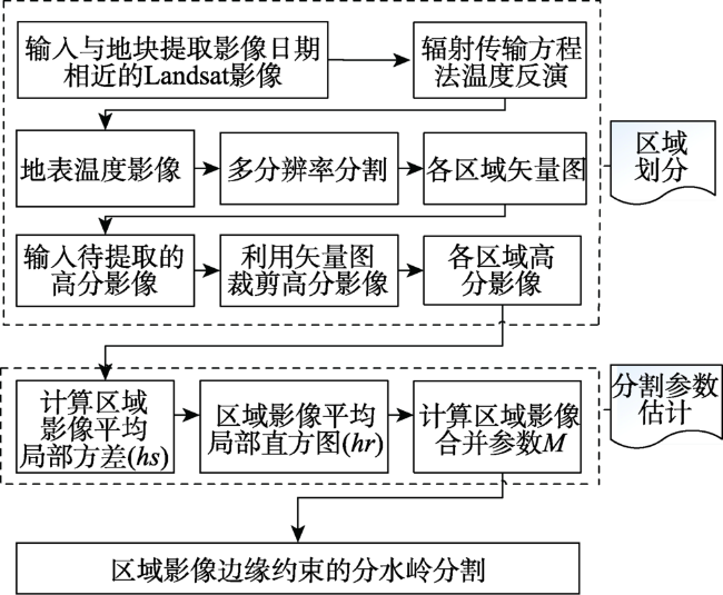
尺度效应的存在使得不同地物的空间及属性尺度存在差异,不存在适合于影像中所有地物的唯一尺度。但通过影像分区,然后针对不同区域设置最优分割参数,可以有效地提高影像整体的分割精度。耕地地块分割中,对分割边界的要求较高,需要保证地块边界清晰连续,鉴于此,本文提出了一种结合影像分区及尺度估计的耕地地块提取方法。本文利用不同地物的温度反演影像来实现区域划分,根据温度数据将影像划分为不同地物类型、作物类型或作物长势不同的多个区域。接下来,分别对不同的区域影像进行分割,由于不同类型地物的固有空间空间尺度不同,所以不同区域影像的最佳分割参数也随之不同。空间统计的平均局部方差法可以用来预估各区域影像的分割参数,与分割参数优选的方法相比,该方法可快速准确定位,且效率较高。因此本文利用该方法进行参数估计,采用边缘约束分水岭分割算法进行耕地地块分割。此外,本文对现有影像分割评价指标进行了改进。实验结果显示,本文提出的耕地地块提取方法可针对影像的不同区域,快速准确地设置分割参数,且与其他分割方法相比,地块边界更清晰连续、多边界问题得到了极大改善。
周文 , 明冬萍 , 闫鹏飞 . 结合影像分区与尺度估计的耕地提取方法研究[J]. 地球信息科学学报, 2018 , 20(7) : 1014 -1025 . DOI: 10.12082/dqxxkx.2018.180076
Influenced by scale effect, different objects have different spatial and attribute scales, so there is no one set of segmentation parameters can suit all objects in the same image. However, classifying similar objects into same region, and then setting optimal segmentation parameters for different regions can improve the overall segmentation accuracy of the images effectively. In cultivated land extraction, it is critical to have clear and continuous boundary for the segmented plots. This paper presents a cultivated land extraction method combining image region division and segmentation parameters estimation. Temperature inversion was used to divide the image into different regions, of which the types of covered objects are different or the growths of crops are different. Next, regional image segmentation is performed for different regions. Since different object's inherent spatial scales are different, so different regional images' optimal segmentation parameters are also different. The optimal segmentation parameters of the image can be estimated to a certain level by analyzing the characteristics of the image space quantitatively. Compared with other segmentation parameter optimization selection methods, this method can be accurately and quickly positioned, and has a higher efficiency. Next, estimated segmentation parameters were used in the process of cultivated land segmentation by using edge restraint watershed segmentation algorithm. Edge restraint watershed segmentation algorithm uses the canny operator for the post-processing of the watershed segmentation algorithm. The boundary of the canny operator is used to constrain the consolidation process. The experimental result shows that the method proposed in this paper can set segmentation parameters for different regions quickly and accurately. Compared with other segmentation methods, this propose method has a quite clearer and more continuous block boundaries and the boundary fragmentation problem is greatly relieved.
Fig. 1 Flow chart of arable land plots segmentation technology图1 耕地地块分割技术流程图 |
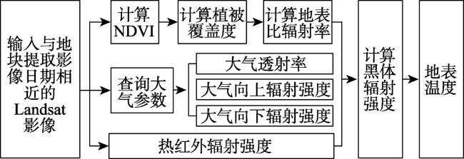
Fig. 2 Temperature inversion flow chart图2 温度反演流程图 |
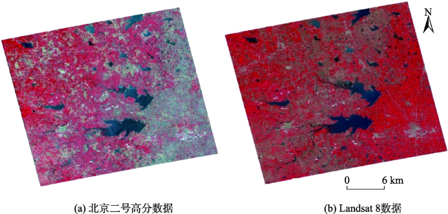
Fig. 3 Experimental data图3 实验数据 |
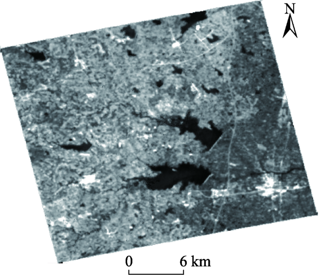
Fig. 4 Temperature inversion data图4 温度反演数据 |
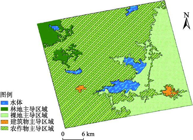
Fig. 5 Region division result of Beijing No.2 satellite data image图5 北京二号影像分区结果 |
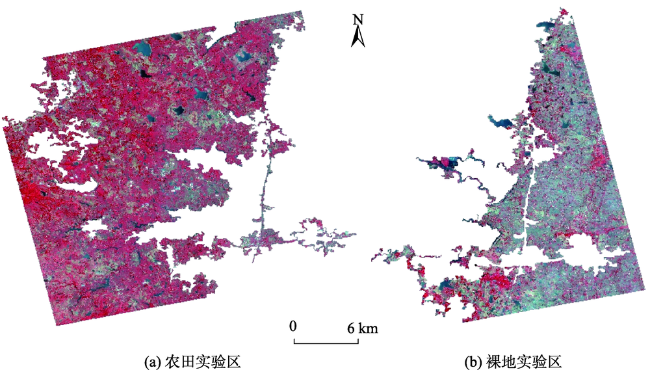
Fig. 6 Regional experimental image图6 区域试验影像 |
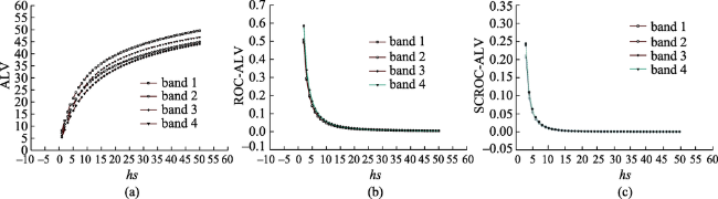
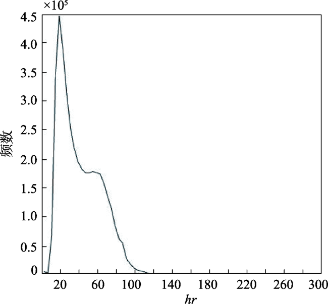
Fig. 7 Mean local variance and its related parameters for bare land image图7 裸地影像平均局部方差及其相关参数 |
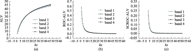
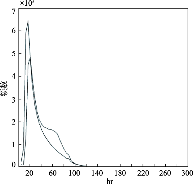
Fig. 8 Mean local variance and its related parameters for crop land image图8 农田影像平均局部方差及其相关参数 |
Fig. 9 Histogram of local variance of bare land image图9 裸地影像局部标准差直方图 |
Fig. 10 Histogram of local variance of crop land image图10 农田影像局部标准差直方图 |
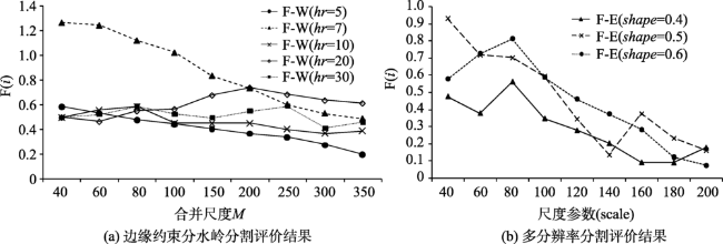
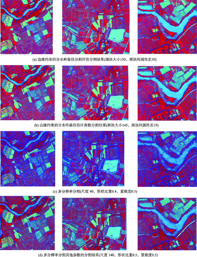
Fig. 11 Evaluation of segmentation results of bare land image图11 裸地试验区分割评价 |
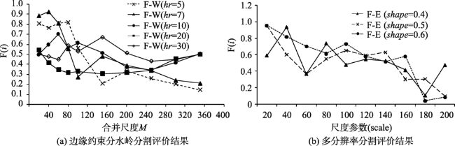
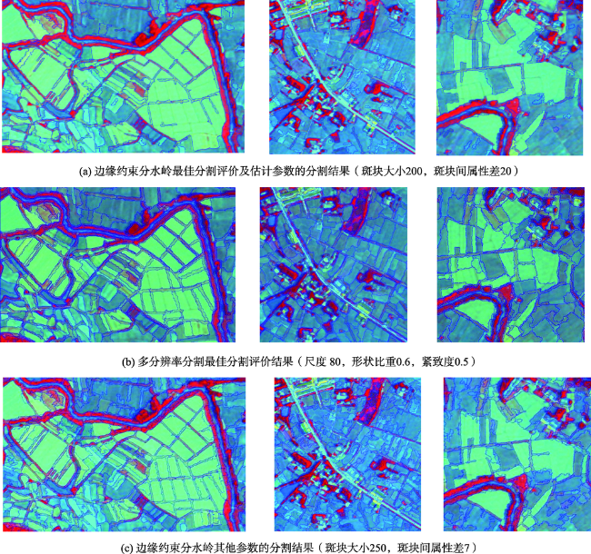
Fig. 12 Evaluation of segmentation results of crops image图12 农田试验区边缘约束分水岭分割评价 |
Fig. 13 Comparison of edge-constrained watershed and multi-resolution segmentation result图13 边缘约束的分水岭与多分辨率分割结果对比 |
Fig. 14 Comparison of edge-constrained watershed and multi-resolution segmentation result图14 边缘约束的分水岭与多分辨率分割结果对比 |
Tab. 1 Comparison of two segmentation methods in bare land image表1 裸地影像2种分割方法对比 |
| 最佳评价结果 | 边缘约束分水岭分割 | 多分辨率分割 | |
|---|---|---|---|
| 基元数 | 1900284 | 2388 | |
| Ui | 2029.231 | 353.086 | |
| Vi | -0.042009 | 0.119191 | |
| A(i) | 0.021250899 | -0.058179414 | |
Tab. 2 Comparison of two segmentation methods in bare crops image表2 农田试验区影像2种分割方法对比 |
| 最佳评价结果 | 边缘约束分水岭分割 | 多分辨率分割 |
|---|---|---|
| 基元数 | 1840250 | 9120 |
| Ui | 927.049 | 127.009 |
| Vi | -0.048007 | 0.000182 |
| A(i) | 0.024542846 | 0.003845729 |
The authors have declared that no competing interests exist.
| [1] |
[
|
| [2] |
[
|
| [3] |
[
|
| [4] |
|
| [5] |
[
|
| [6] |
|
| [7] |
|
| [8] |
[
|
| [9] |
|
| [10] |
|
| [11] |
|
| [12] |
|
| [13] |
|
| [14] |
|
| [15] |
[
|
| [16] |
[
|
| [17] |
[
|
| [18] |
[
|
| [19] |
[
|
| [20] |
[
|
| [21] |
[
|
| [22] |
[
|
| [23] |
[
|
| [24] |
[
|
| [25] |
[
|
| [26] |
[
|
| [27] |
[
|
| [28] |
|
| [29] |
|
| [30] |
[
|
/
| 〈 |
|
〉 |