
基于自发地理信息的“一带一路”区域陆路交通状况分析
网络出版日期: 2018-08-24
Analyzing the Land Transportation Conditions in the Belt and Road Area Based on Volunteered Geographic Information
Online published: 2018-08-24
Copyright
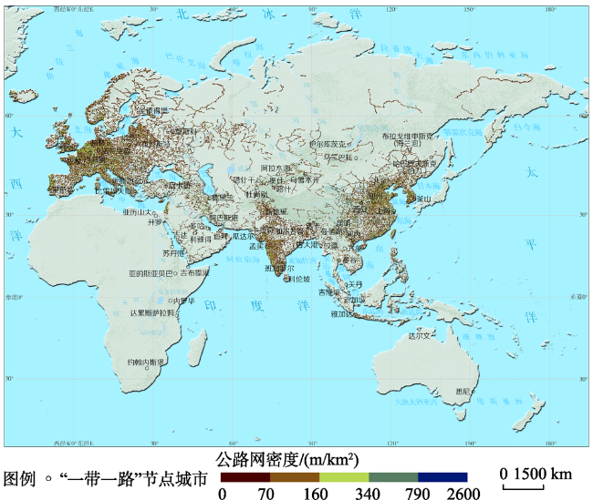
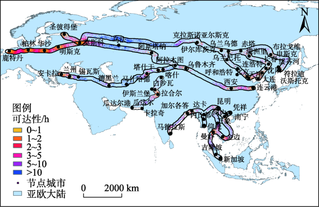
路网密度的研究是实施“一带一路”愿景之互联互通倡议的基础工作。“一带一路”顺应了世界经济全球化、一体化、多极化、信息化的趋势,牵连着蓬勃发展的亚太和发达的欧洲经济圈,带动中间国家的经济发展。在新形势下,如何通过交通基础设施建设推进丝绸之路经济带沿线区域间的互联互通、促进区域合作和经济发展,具有重要的现实意义。本文利用自发地理信息数据——OpenStreetMap(OSM)道路网数据,运用地理信息系统(GIS)空间分析技术,探究了“一带一路”陆路经济带辐射区域亚欧大陆的路网络密度和通行能力的空间分布格局,并分析了六大经济走廊节点城市的公路可达性空间格局。结果表明:“一带一路”陆路经济带的交通基础设施的发展存在着不平衡现象;路网密度和通行能力均呈现沿海高内陆低的空间格局;中亚、西亚地区和中南半岛地区成为道路水平落后带,限制了丝绸之路经济带资源整合与贸易畅通,建议在建设新跨国公路铁路同时,对原有老旧道路进行加宽加固等升级改造;全区域道路等级级配不合理;节点城市可达性具有明显的分异状况,六大经济走廊中83%的区域可达性在10 h以内。研究产出亚欧大陆1 km分辨率路网密度和通行能力数据集,发现了“一带一路”陆路经济带道路水平的薄弱区域,为“一带一路”陆路经济带的交通基础设施建设以及进一步的道路网研究提供了基础数据。
寇培颖 , 牛铮 , 刘正佳 , 李旺 . 基于自发地理信息的“一带一路”区域陆路交通状况分析[J]. 地球信息科学学报, 2018 , 20(8) : 1074 -1082 . DOI: 10.12082/dqxxkx.2018.180090
Analysis on the road network is the basis for implementing the connectivity projects during the Initiative for the Belt and Road. The Belt and Road conforms to the trend of global economic globalization, integration, multi-polarization, and informatization. It implicates a thriving Asia-Pacific and developed European economic circles and drives the economic development of the intermediate countries. Under the new circumstances of the Belt and Road, it is of great practical significance to promote regional cooperation and economic development through the construction of transportation infrastructure along the Silk Road economic belt. In this study, based on the Volunteered Geographic Information (VGI), namely, OpenStreetMap (OSM) road network data of the Eurasian continental, the road network density and weighted road network density were calculated by Geographic Information System (GIS) spatial analysis techniques, and the spatial patterns of urban accessibility for the six economic corridors were studied. Following results have been obtained: there was an imbalance in the development of Land Transportation over the Belt and Road. The road network density and traffic capacity were higher in coastal areas than that in the inland areas. Central Asia, West Asia and Indo-china Peninsula are lagging areas that have restricted the integration of the resources and the smooth flow of trade in the Silk Road Economic Belt. It is suggested that at the same time as the construction of a new transnational road and railway, the existing old roads should be widened, reinforced, and upgraded. The grade levels of the roads across the region are in unreasonable coordination. The spatial distribution of urban accessibility in the six economic corridors showed an obvious interval pattern, and the accessibility of 83% of regions are within 10 h. This study showed that the undeveloped area of road in the Belt and Road, providing a fundamental dataset and support for the study on traffic infrastructure construction of the Belt and Road.
Tab. 1 Six economic corridors and the node cities in the Belt and Road表1 “一带一路”六大经济走廊与节点城市 |
| 经济走廊 | 途径主要国家及地区 | 节点城市 |
|---|---|---|
| 中蒙俄经济走廊 | 中国、蒙古、俄罗斯 | 北京、天津、大连、二连浩特、沈阳、长春、乌兰巴托、赤塔、伊尔库茨克、莫斯科、圣彼得堡等 |
| 新亚欧大陆桥经济走廊 | 中国、哈萨克斯坦、白俄罗斯、波兰等 | 连云港、西安、兰州、乌鲁木齐、华沙、柏林、鹿特丹等 |
| 中国-中亚-西亚经济走廊 | 中国、哈萨克斯坦、乌兹别克斯坦、伊朗等 | 乌鲁木齐、塔什干、阿拉木图、德黑兰、安卡拉、伊斯坦布尔等 |
| 中国-中南半岛经济走廊 | 中国、越南、新加坡等 | 南宁、仰光、凭祥、河内、金边、曼谷、新加坡等 |
| 中巴经济走廊 | 中国、巴基斯坦 | 喀什、白沙瓦、伊斯兰堡、拉合尔、卡拉奇、瓜达尔港等 |
| 孟中印缅经济走廊 | 中国、印度、孟加拉、缅甸 | 昆明、仰光、曼德勒、内比都、达卡、加尔各答、马德拉斯等 |
Tab. 2 Weights of road communication capacity in Eurasia表2 亚欧大陆道路通行能力权重 |
| 道路级别 | |||||
|---|---|---|---|---|---|
| 高速公路/快速公路 | 主干道路/城市快速路 | 主要道路 | 次要道路 | 普通街道 | |
| 权重 | 4 | 2 | 1.6 | 1.4 | 1 |
Tab. 3 Speed and time cost of highway表3 各级公路时速与时间成本 |
| 道路级别 | ||||||
|---|---|---|---|---|---|---|
| 高速公路/快速公路 | 主干道路/城市快速路 | 主要道路 | 次要道路 | 普通街道 | 其余等级道路 | |
| 速度/(km/h) | 100 | 100 | 80 | 60 | 50 | 40 |
| 时间成本/min | 0.6 | 0.6 | 0.75 | 1 | 1.2 | 1.5 |
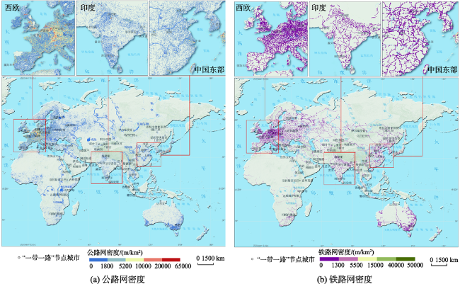
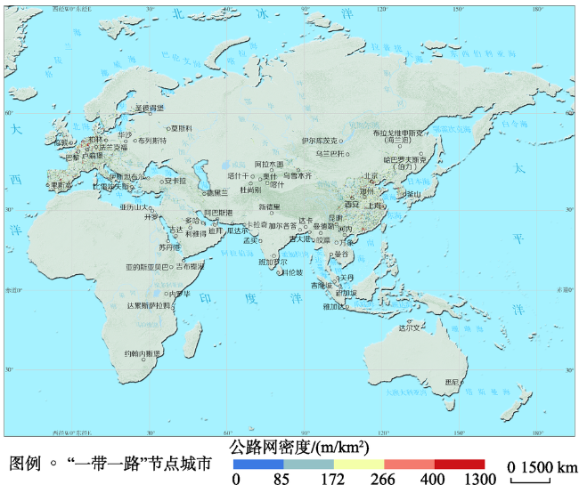
Fig. 1 Distribution of road density in Eurasian continental图1 亚欧大陆路网密度分布状况 |
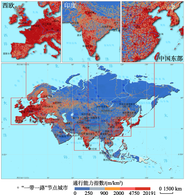
Fig. 2 Distribution of weighed road density in Eurasian continental图2 亚欧大陆陆路交通通行能力分布状况 |
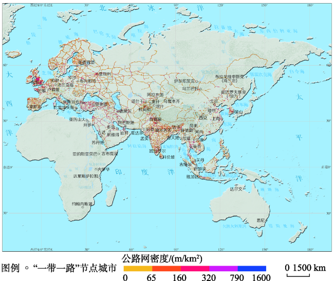
Fig. 3 Distribution of motorway road density in Eurasian continental图3 亚欧大陆高速公路网密度分布状况 |
Fig. 4 Distribution of trunk road density in Eurasian continental图4 亚欧大陆主干道路网密度分布状况 |
Fig. 5 Distribution of primary road density in Eurasian continental图5 亚欧大陆主要道路网密度分布状况 |
Fig. 6 Accessibility of cities in the six economic corridors图6 六大经济走廊城市可达性 |
The authors have declared that no competing interests exist.
| [1] |
[
|
| [2] |
[
|
| [3] |
|
| [4] |
[
|
| [5] |
[ The influence of the construction of the transportation infrastructure on the regional trade in the "Silk Road" economic belt[J]. Enterprise Economy,2014(3):156-159. ]
|
| [6] |
[
|
| [7] |
[
|
| [8] |
Bureau of Transportation Statistics[M]. USA: Department of Transportation, 1999.
|
| [9] |
|
| [10] |
[
|
| [11] |
[
|
| [12] |
[
|
| [13] |
[
|
| [14] |
[
|
| [15] |
[
|
| [16] |
[
|
| [17] |
[
|
| [18] |
中华人民共和国国家发展和改革委员会,
[
|
| [19] |
[
|
| [20] |
[
|
| [21] |
|
| [22] |
|
| [23] |
|
| [24] |
|
| [25] |
[
|
| [26] |
|
| [27] |
[
|
| [28] |
[
|
| [29] |
[
|
| [30] |
[
|
| [31] |
[
|
| [32] |
[
|
| [33] |
[
|
| [34] |
|
/
| 〈 |
|
〉 |