
基于SRTM数据的广东新一代天气雷达覆盖研究
作者简介:李明凤(1994-),女,助理工程师,主要从事短时临近预报研究。E-mail: limingfengcc@163.com
收稿日期: 2018-03-25
要求修回日期: 2018-05-03
网络出版日期: 2018-08-24
基金资助
中山大学“百人计划二期”急需青年杰出人才项目(74110-52601108)
中国气象局预报员专项(CMAYBY2018-052)
广东省气象局科研项目(2015Q15)
Analysis of CINRAD Coverage in Guangdong Province Based on SRTM Data
Received date: 2018-03-25
Request revised date: 2018-05-03
Online published: 2018-08-24
Supported by
“100 Top Talents Program” at Sun Yat-sen University, No.74110-52601108
China Meteorological Administrator Forecaster Special Item, No.CMAYBY2018-052
Guangdong Meteorological Service Research Project, No.2015Q15.
Copyright
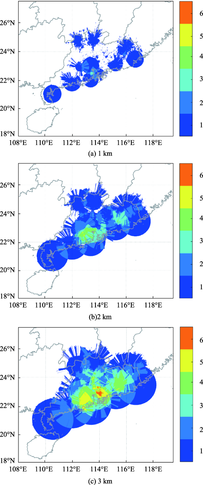
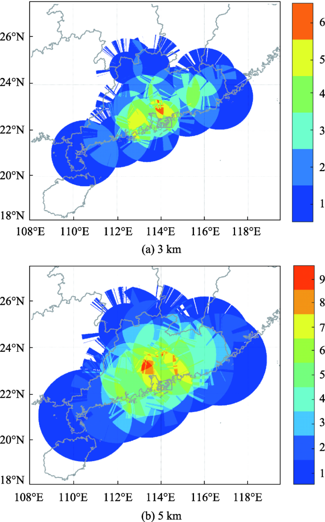
本文利用SRTM3高分辨率的数字高程模型(DEM)对广东省已建成的12部新一代天气雷达分别进行地形阻挡分析。结果表明,在低仰角(0.5°)的观测结果中,韶关、连州以及肇庆雷达受地形阻挡较严重,深圳、阳江、梅州和汕尾的雷达也有大面积阻挡区域,其余雷达的覆盖效果均很好。随着扫描仰角的抬高,地形对雷达波束的阻挡有所减弱。从第4个仰角 (3.4°)开始,所有雷达均无地形阻挡。在海拔5 km范围内12部雷达可以完全覆盖广东全省,大部分地区至少有4部雷达重叠。离地3 km和海拔3 km的雷达覆盖情况均显示,除广东省北部和西北部极少部分地区没有雷达覆盖外,大部分地区均有2部以上雷达覆盖,珠江三角洲入海口一带甚至有4~6部雷达重叠。在离地2 km范围内,广东省雷达组网能够有效覆盖广东省大部分区域。在离地1 km范围内,广东省北部和西北部雷达覆盖效果不太理想,存在较大的空白区。在离地高度2 km和海拔高度3 km以上,雷达组网基本可以覆盖广东全境,因此可以认为广东省雷达的总体布局较好。
李明凤 , 闵超 , 张阿思 , 肖柳斯 , 黄朝盈 , 詹棠 , 陈生 . 基于SRTM数据的广东新一代天气雷达覆盖研究[J]. 地球信息科学学报, 2018 , 20(8) : 1201 -1208 . DOI: 10.12082/dqxxkx.2018.180121
The China Meteorological Administration (CMA) has constructed a radar network of China next generation weather radar (CINRAD) to detect precipitation. In order to investigate the coverage condition of weather radar network, high-resolution digital elevation data of SRTM3 were used to analyze the terrain-blockage of 12 weather radars deployed in Guangdong Province. The beam blockage by mountain was calculated with the following method. Firstly, if the first tilt radar beam is blocked up to 50%, then it is considered that the radar beam does not scatter in the forward direction and the radar beam will jump to the next tilt at the blocked area, the obstructed slant range will be replaced by the second elevation. Secondly, if the mountain peaks are still higher than the radar beam and the radar beam is blocked up to 50%, the third tilt will be adopted. Results show that Shaoguan, Lianzhou and Zhaoqing radars suffer from serious beam blockage at the lowest elevation (0.5°). Additionally, Shenzhen, Yangjiang, Meizhou and Shanwei radars have large blocked areas at 0.5° elevation scan while the rest of radars have a very good coverage. With the raise of radar elevation, the beam blockage will be weaked or the more beams will clear the surface. At 3.4° elevation, all of 12 radars do not suffer from beam blockage. The 12 radars can completely cover Guangdong Province within the height of 5 km above mean sea level (MSL), and there are four adjacent radars in most areas. Radar coverage maps at the height of 3 km above ground level (AGL) and 3 km above MSL show that only a few regions in northern and northwestern Guangdong Province have no radar coverage, while most areas generally have more than 2 radars coverage, and there are 4-6 radars overlapping in the Pearl River Delta area. Within the height of 2 km AGL, the CINRAD network can effectively cover most regions of Guangdong province. Only within the height of 1 km, radar coverage in the northern and northwestern Guangdong Province is a little poor. Generally, the CINRAD network can monitor almost the entire Guangdong Province at height of 2 -3 km AGL and 3-5 km above MSL, thus, the distribution of radar is relatively good in Guangdong Province.
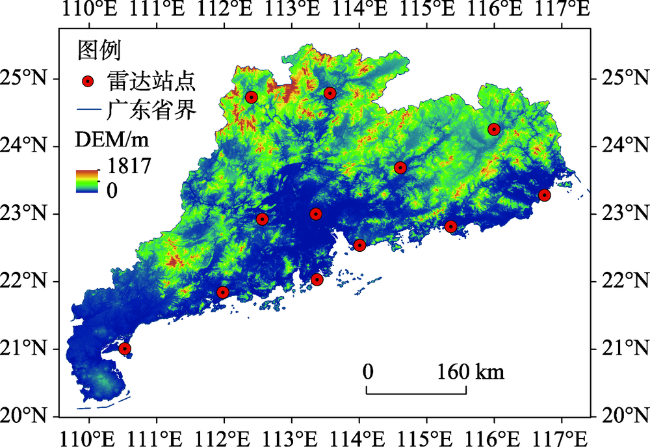
Fig. 1 Terrain and distributions of radar sites in Guangdong Province图1 广东省地形及雷达站点的分布示意图 |
Tab. 1 Parameters of China next generation weather radars in Guangdong表1 广东新一代天气雷达参数 |
| 站名 | 站号 | 型号 | 海拔/m |
|---|---|---|---|
| 珠海 广州 汕尾 阳江 韶关 梅州 汕头 深圳 肇庆 湛江 河源 连州 | Z0756 Z9200 Z9660 Z9662 Z9751 Z9753 Z9754 Z9755 Z9758 Z9759 Z9762 Z9763 | CINRAD /SD CINRAD/SA CINRAD/SA CINRAD/SA CINRAD/SA CINRAD/SA CINRAD/SA CINRAD/SA CINRAD/SA CINRAD/SA CINRAD/SA CINRAD/SA | 257 180.6 323 102.8 301.9 423 199.8 149.1 95.8 106.1 1076 632.1 |
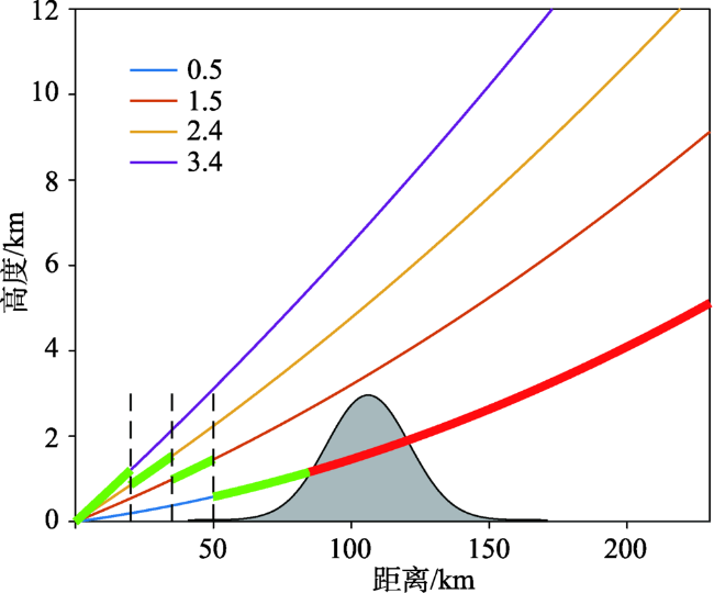
Fig. 2 The hybrid scan method of coverage for radar without considering beam blockage |
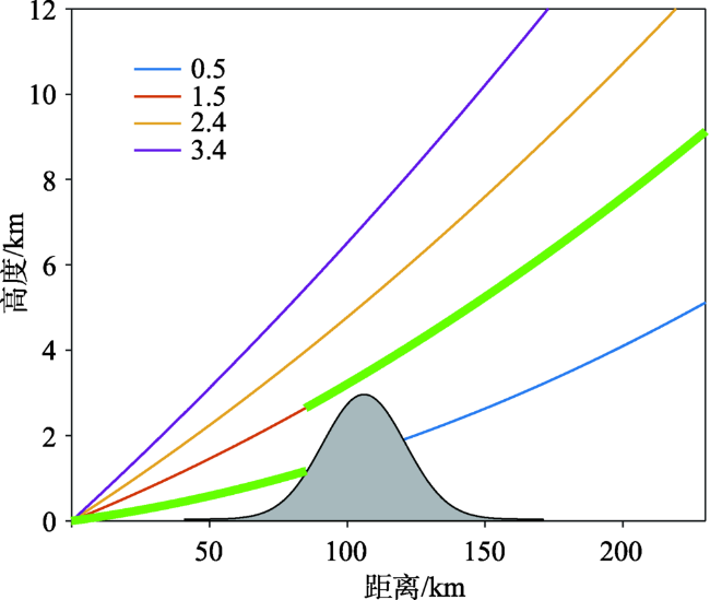
Fig. 3 The hybrid scan method of coverage for radar with considering beam blockage |

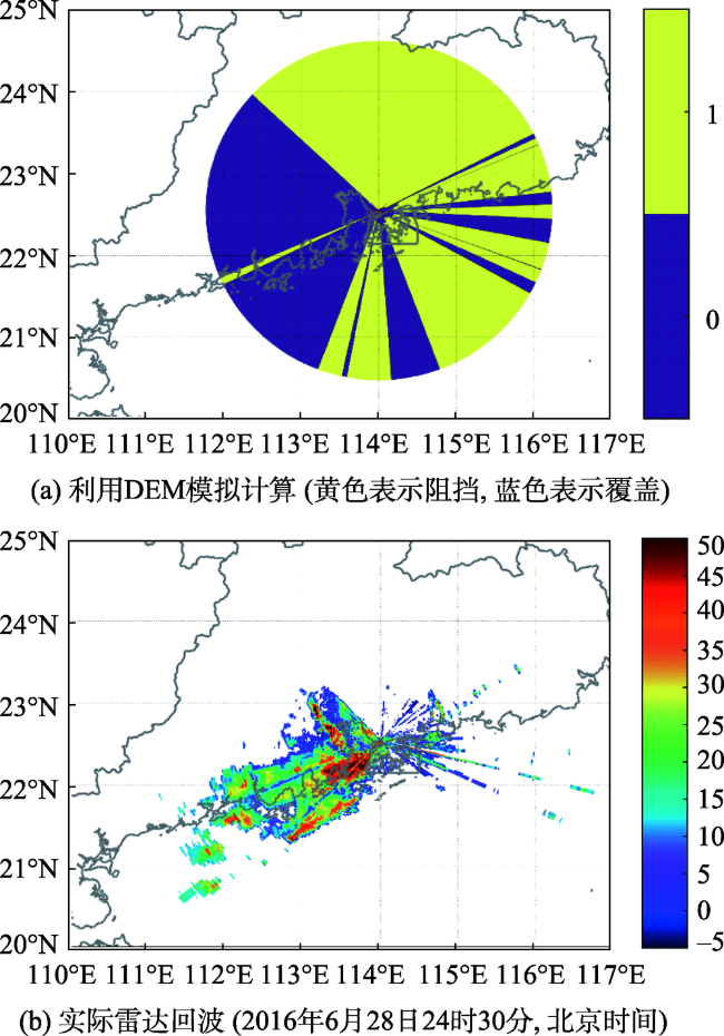
Fig. 4 Beam blockage of CINRAD by mountain in Shenzhen at 0.5° level图4 深圳雷达0.5°仰角地形阻挡分析 |
Fig. 5 The coverage and overlapping of 12 CINRADs over Guangdong Province at height of 1, 2 and 3 km AGL图5 广东省12部雷达在离地1、2和3 km的覆盖范围和雷达叠加数 |
Fig. 6 The coverage and overlapping of 12 CINRADs over Guangdong Province at height of 3 km and 5 km above MSL图6 广东省12部雷达在海拔3 km和5 km 的覆盖效果和雷达叠加数 |
The authors have declared that no competing interests exist.
| [1] |
|
| [2] |
|
| [3] |
|
| [4] |
|
| [5] |
[
|
| [6] |
[
|
| [7] |
[
|
| [8] |
[
|
| [9] |
[
|
| [10] |
[
|
| [11] |
[
|
| [12] |
[
|
| [13] |
[
|
| [14] |
[
|
| [15] |
|
| [16] |
[
|
| [17] |
[
|
| [18] |
|
| [19] |
[
|
| [20] |
[
|
/
| 〈 |
|
〉 |