
一种新的ROAM算法及其在地形建模中的应用
作者简介:李朝奎(1967-),男,博士,湖南汉寿人,教授,博士生导师,研究方向为三维地理建模及其应用。E-mail: chkl_hn@163.com
收稿日期: 2018-01-15
要求修回日期: 2018-06-22
网络出版日期: 2018-09-25
基金资助
国家自然科学基金项目(41571374)
国家重点研发计划项目(2017YFB0503802)
湖南省教育厅重点项目(16A070)
湖南省自然科学基金湘潭联合基金(2017JJ4037)
特殊环境道路工程湖南省重点实验室开放基金项目(kfj150502)
A New ROAM Algorithm and Its Application in Terrain Modeling
Received date: 2018-01-15
Request revised date: 2018-06-22
Online published: 2018-09-25
Supported by
The National Natural Science Fund, No.41571374
National Key Research and Development Plan, No.2017YFB0503802
The Key Project of the Hunan Provincial Department of Education, No.16A070
Hunan and Xiangtan Joint Natural Science Fund, No.2017JJ4037
The Open Fund of the Key Laboratory of Hunan province for Special Environmental Road Engineering, No.kfj150502.
Copyright
地形建模是数字地形分析的重要基础工作。实时优化适应性网格算法(ROAM算法)是目前常用的地形建模方法。但ROAM算法应用于地形可视化实时渲染时要求原始数据为正方形,且渲染后常有裂缝产生,因而该法在地形建模实践中受到较大的限制。针对ROAM算法存在的上述不足,本文提出了基于内接正方形插值方法的改进ROAM算法。通过将多边形分割为一个内接正方形和多个边缘多边形,用多边形的一个顶点依次与其他顶点相连,使边缘多边形分割为多个三角形,并根据边缘三角形面积大小,确定是否对边缘多边形进行继续分割,由此解决数据源限定为正方形的问题,利用添加拆分点的方法消除地形渲染产生的裂缝。采用不规则地形的灰度图作为高程数据源进行地形模拟实验,结果表明:改进后的ROAM算法能够消除裂缝,且对数据源无约束性要求,降低了算法复杂度,提高了整体可视化性能,能够满足地形实时动态显示的要求。
李朝奎 , 王宁 , 吴柏燕 , 方军 , 杨文涛 , 褚楠 . 一种新的ROAM算法及其在地形建模中的应用[J]. 地球信息科学学报, 2018 , 20(9) : 1209 -1215 . DOI: 10.12082/dqxxkx.2018.180050
Terrain modeling is important in the digital terrain analysis. Real-time adaptive mesh algorithm (ROAM algorithm) is a commonly used terrain modeling method. However, applying ROAM algorithm to real-time rendering of terrain visualization requires the original data to be square and cracks often occur after rendering, so this method is greatly restricted in the practice of terrain modeling. Aiming at the above disadvantages of the ROAM algorithm, an improved ROAM algorithm based on the interpolation of inner square is proposed in this paper. The polygon is divided into an inner square and multiple edge polygons, then the vertexes of these polygons are connected sequentially to divide the polygons into multiple triangles, and according to the size of the edge triangles, whether to continue segmentation of the edge polygon is determined. Thus, the problem of limiting the data source to a square is solved, and the crack generated by the terrain rendering is eliminated by adding split points. Using the irregular terrain gray image as the elevation data for terrain simulation experiment, the results show that the improved levenshtein distance algorithm can eliminate the crack with no binding requirements for data source, reduce the algorithm complexity and improve the overall visual performance. It can meet the requirements of terrain real-time dynamic display.
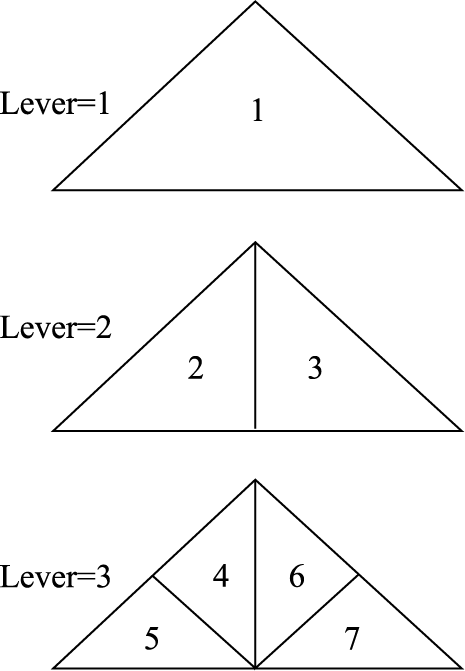
Fig.1 ROAM mesh division principle图1 ROAM网格剖分原理 |
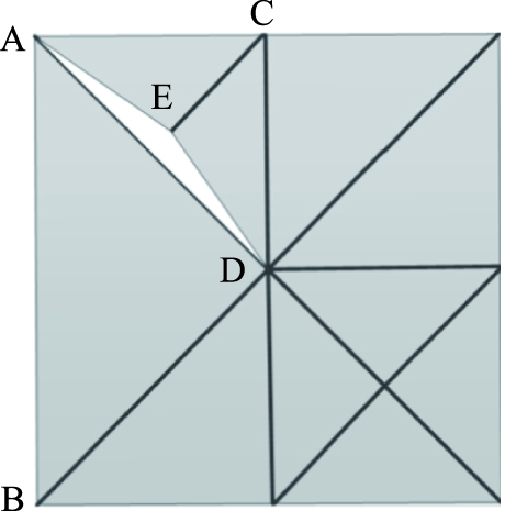
Fig. 2 Generation of cracks in adjacent areas图2 邻区裂缝的产生 |
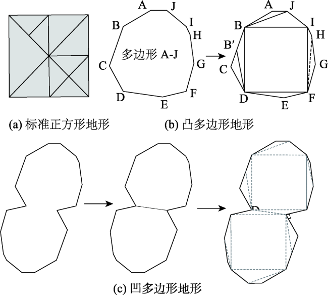
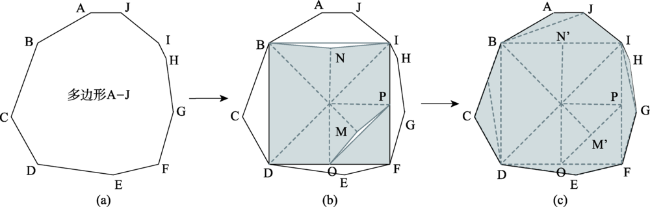
Fig. 3 Different terrain segmentation图3 不同地形分割 |
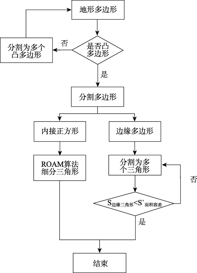
Fig. 4 Flowchart of terrain segmentation algorithm图4 地形分割算法流程 |
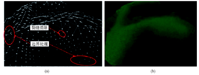
Fig. 5 Repair of terrain cracks图5 地形裂缝修补图 |
Fig. 6 Relationship between triangles图6 三角形间的关系 |
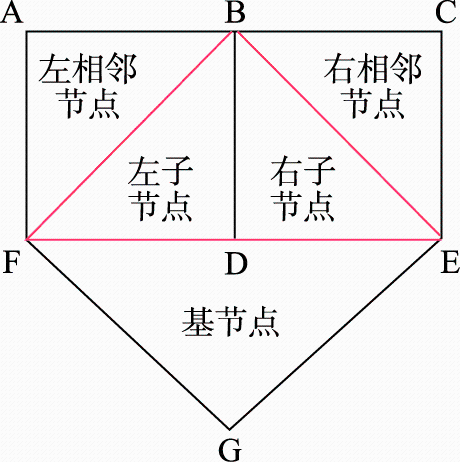
Fig. 7 Left-neighbor nodes in three different situations图7 三种不同情况的左相邻节点 |
Fig.8 Three different cases of the right adjacent nodes图8 3种不同情况的右相邻节点 |
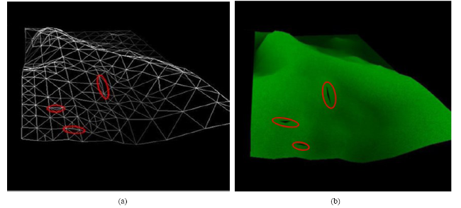
Fig. 9 Standard square data terrain grid without crack elimination图9 未经过裂缝消除的标准正方形数据地形网格 |
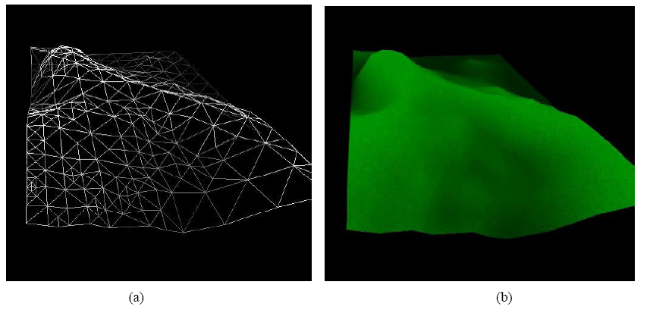
Fig.10 Standard square data terrain grid through crack elimination图10 经过裂缝消除的标准正方形数据地形网格 |
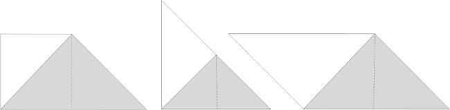
Fig.11 Model of forced segmentation图11 强制分割建模模型 |
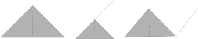
Fig.12 Adding split point modeling model图12 添加拆分点建模模型 |
Tab. 1 Algorithm efficiency comparison表1 算法效率对比 |
| 裂缝修补 | 三角形数量 | 建模时间/ms |
|---|---|---|
| 强制分割法 | 19 712 | 4335.40 |
| 添加拆分点法 | 11 840 | 2309.66 |
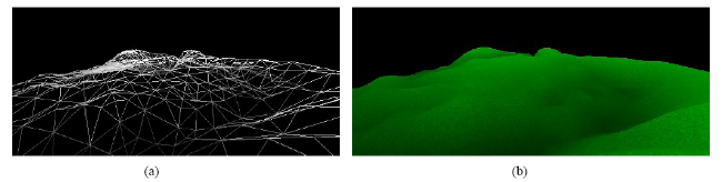
Fig.13 Results of improved ROAM algorithm图13 改进的ROAM算法实验结果 |
The authors have declared that no competing interests exist.
| [1] |
[
|
| [2] |
[
|
| [3] |
[
|
| [4] |
[
|
| [5] |
|
| [6] |
[
|
| [7] |
|
| [8] |
[
|
| [9] |
[
|
| [10] |
[
|
| [11] |
[
|
| [12] |
[
|
| [13] |
[
|
| [14] |
|
| [15] |
[
|
| [16] |
[
|
| [17] |
|
| [18] |
[
|
/
| 〈 |
|
〉 |
