
秦巴山地山体基面高度的提取及分布
作者简介:刘俊杰(1995-),女,河南周口人,硕士生,主要从事山地GIS、山地地理研究。E-mail: junjieliu555@163.com
收稿日期: 2018-05-07
要求修回日期: 2018-07-21
网络出版日期: 2018-10-17
基金资助
国家自然科学基金项目(41601091)
中国南北过渡带综合科学考察项目(2017FY100900)
Extraction and Distribution of Mountain Base Elevation in the Qinling-Daba Mountains
Received date: 2018-05-07
Request revised date: 2018-07-21
Online published: 2018-10-17
Supported by
National Natural Science Foundation of China, No.41601091
Integrated Scientific Investigation of the North-South Transitional Zone of China.
Copyright
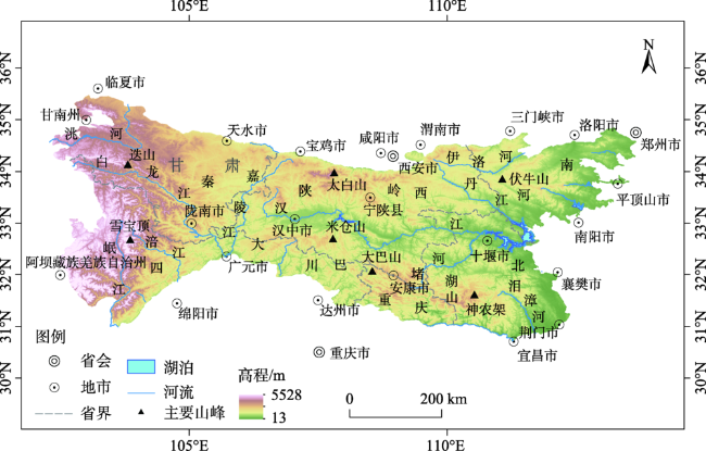
秦巴山地是中国的南北分界线,也是黄河和长江的分水岭,其山体效应的定量化影响秦巴山地山体垂直带的分布格局、非地带性因素的作用强度和机理,以及中国暖温带和北亚热带的具体位置的确定。山体基面高度是影响山体效应最重要和关键的地形因子,其定量化和数字化提取是秦巴山地山体效应定量化研究的重要内容。本研究针对秦巴山地山体效应的定量化研究,使用30 m分辨率的STRM-1数据,分别基于山体特征线和流域分区2种方法提取了秦巴山地的山体基面高度分区,并根据地形起伏度和坡度,确定基面范围,计算了山体基面高度值。结果表明:① 基于山体特征线的方法将秦巴山地分为93个基面高度分区,基于流域分区的方法将秦巴山地分为209个基面高度分区,根据2种分区结果提取的基面高度值相差不大且均体现了秦巴山地地势的特点;② 秦巴山地山体基面高度从东向西呈阶梯状递增的趋势;③ 从南到北,秦巴山地的东段和中段均呈先增高后降低的趋势,即从大巴山向北至汉江谷地降低,再向北至秦岭升高;④ 山地的不同侧翼的山体基面高度不同,秦岭南坡的基面高度(1000~1809 m)明显高于北坡(850~1300 m)。秦巴山地山体基面高度与其植被带分布上限联系密切,实现山体基面高度的数字化提取,为山体效应的定量化研究提供了重要的技术支持。
刘俊杰 , 秦奋 , 赵芳 , 曹艳萍 . 秦巴山地山体基面高度的提取及分布[J]. 地球信息科学学报, 2018 , 20(10) : 1457 -1466 . DOI: 10.12082/dqxxkx.2018.180227
As the North-South boundary of China and the watershed between Yellow River and Yangtze River, the Qinling-Daba Mountains are characterized with complicated and transitional variations in mountain altitudinal belts. For a longtime, latitude, longitude and mountain mass effect (MEE) have been considered to affect the vertical distribution of montane vegetation or altitudinal belts. The two former factors reflect the zonality of the geological distribution of vegetation and have receiving much attention, but MEE, an important factor for montane vegetation variation, is often overlooked because of the lack of effective quantitative methods for it in the Qinling-Daba Mountains. Quantification of MEE contributes to understanding azonal factors and the transitional characteristics between warm-temperate and north subtropical zone in China. Mountain base elevation (MBE), as a topographic factor, related to MEE closely, and recognition and quantification of it is indispensable for quantifying MEE. This study aims at quantifying MBE based on STRM-1 data with 30m resolution in the Qinling-Daba Mountains. We used two methods (based on mountain characteristics and based on drainage basin division) to determine mountain base subareas and then used relief amplitude, the average altitude in each subareas and slope to calculate the MBE. The results show that: (1) There are 93 subareas based on mountain characteristics method and 209 subareas based on drainage basin division method in the Qinling-Daba Mountains. The two MBEs have similar values and distributions and reflect the characteristics of the terrain of the study areas. (2) From east to west, MBE presents a gradual upward trend. (3) Along latitudinal direction, MBE presents a tendency of increasing from the Hanjiang Valley to the Qinling ridge and the Daba ridge. (4) The MBEs vary greatly in different exposures, from 1000m to 1809m in the southern flank of the Qinling, but only 850~1300 m in the northern flank. The MBE extracting methods will provide important technical support for the quantitative research of MEE in the Qinling-Daba Mountains.
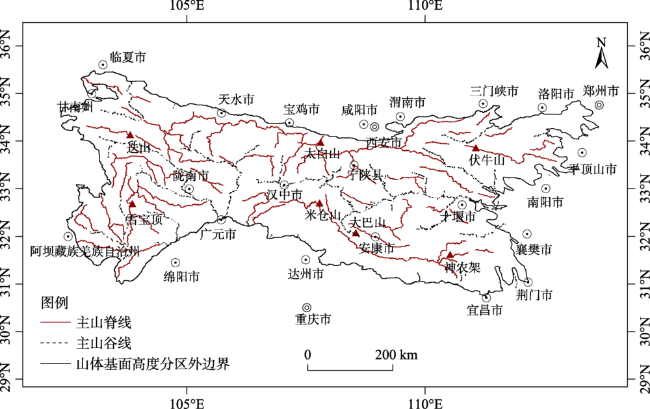
Fig. 1 The distribution of the Qinling-Daba Mountains图1 秦岭大巴山区域图 |
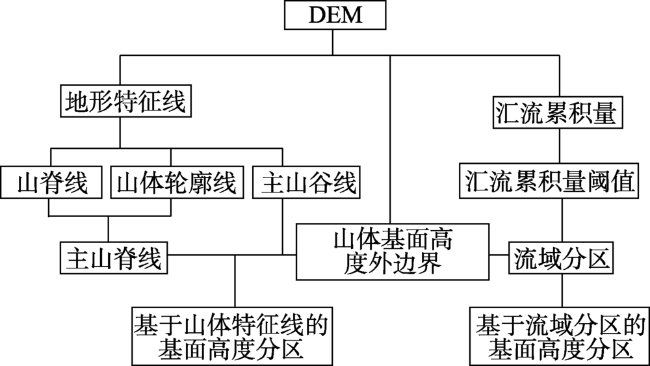
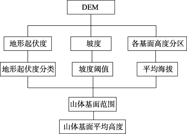
Fig. 2 The process of extraction of mountain base subarea in the Qinling-Daba Mountains图2 山体基面高度分区方法 |
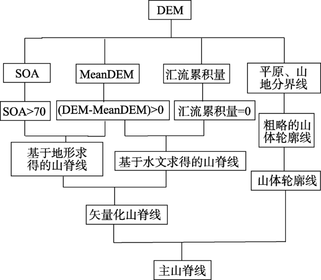
Fig. 3 The process of extraction of main ridge-line in the Qinling-Daba Mountains图3 主山脊线提取方法 |
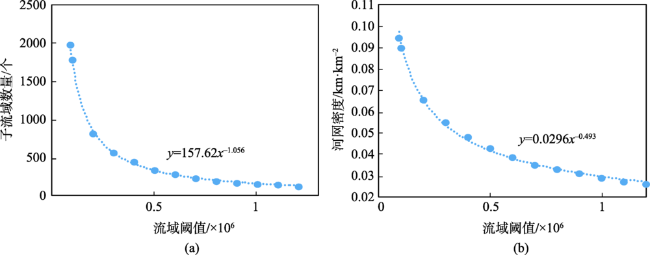
Fig. 4 The relationships between confluence threshold and the quantities of sub-basin and river density in the Qinling-Daba Mountains图4 秦巴山地子流域数量和河流密度随汇流累积量阈值变化 |
Fig. 5 The extraction of mountain characteristic lines in the Qinling-Daba Mountains图5 山体特征线提取结果 |
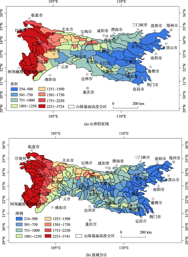
Fig. 6 The quantification results of mountain base elevation based on mountain characteristics and drainage basin division in the Qinling-Daba Mountains图6 基于山体特征线与流域分区的山体基面高度提取结果 |
Fig. 7 The process of extraction of mountain base elevation in the Qinling-Daba Mountains图7 山体基面高度提取方法 |
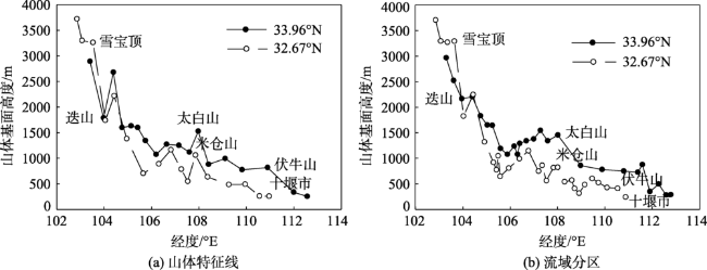
Fig. 8 The distribution of mountain base elevation based on mountain characteristics and drainage basin division from west to east in the Qinling-Daba Mountains图8 基于山体特征线和基于流域分区的山体基面高度(西-东)变化情况 |
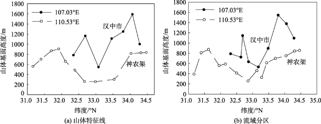
Fig. 9 The distribution of mountain base elevation based on mountain characteristics and drainage basin division from south to north in the Qinling-Daba Mountains图9 基于山体特征线和基于流域分区的山体基面高度(南-北)变化情况 |
The authors have declared that no competing interests exist.
| [1] |
[
|
| [2] |
|
| [3] |
[
|
| [4] |
|
| [5] |
[
|
| [6] |
[
|
| [7] |
|
| [8] |
|
| [9] |
|
| [10] |
[
|
| [11] |
|
| [12] |
[
|
| [13] |
|
| [14] |
|
| [15] |
|
| [16] |
[
|
| [17] |
[
|
| [18] |
[
|
| [19] |
[
|
| [20] |
[
|
| [21] |
[
|
| [22] |
[
|
| [23] |
[
|
| [24] |
[
|
| [25] |
|
| [26] |
[
|
| [27] |
[
|
| [28] |
[
|
| [29] |
[
|
| [30] |
[
|
| [31] |
[
|
| [32] |
[
|
| [33] |
[
|
| [34] |
[
|
| [35] |
[
|
| [36] |
[
|
| [37] |
[
|
| [38] |
[
|
| [39] |
[
|
| [40] |
[
|
| [41] |
|
/
| 〈 |
|
〉 |