
村镇应急公共设施选址布局优化研究
作者简介:詹庆明(1964-),男,福建永安人,博士生导师,研究方向为数字化城乡规划与管理。E-mail: qmzhan@whu.edu.cn
收稿日期: 2018-09-22
要求修回日期: 2019-02-27
网络出版日期: 2019-05-25
基金资助
国家科技支撑计划项目(2014BAL05B07)
Optimization of Emergency Facilities Layout in Villages
Received date: 2018-09-22
Request revised date: 2019-02-27
Online published: 2019-05-25
Supported by
National Science and Technology Support Program, No.2014BAL05B07.
Copyright
应急公共设施对防灾减灾具有重要作用,但相关研究和实践通常围绕城市展开,中国村镇地域广阔、环境复杂,传统方法规划的应急公共设施布局无法满足村镇的需求。因此,针对村镇进行更加精细化的应急公共设施布局优化十分必要。本文主要研究内容包括:① 建立包括地理因素、交通条件、人口分布情况和危险源分布情况在内的应急设施适宜性用地指标体系,并避免在地质灾害、洪水等灾害高发区域建设;② 对仅需要承担应急服务的设施,建立集合覆盖模型和最大化覆盖模型两级选址模型进行分析,对需要承担公共服务和应急服务双重任务的设施,建立集合覆盖模型和p-中值模型进行分析;③ 以响应覆盖率、交叉响应率作为效率性评价指标,最大响应时间、平均响应时间作为公平性评价指标,综合评价设施选址方案。本文以神农架林区松柏镇为研究区域,以消防设施和应急医疗救助中心分别作为两类典型应急公共设施进行布局,得到以下结论:① 应急设施适宜性用地评价指标体系能够综合评价应急设施选址时需要考虑的各种因素,具有较强的实用性;② 对多选址方案进行对比,模型计算结果在效率性和公平性指标方面优于原选址方案,同时结合人口分布、实际用地情况和成本因素能够确定更为优化的布局方案,验证了方法的可行性和科学性。
詹庆明 , 杨爽 . 村镇应急公共设施选址布局优化研究[J]. 地球信息科学学报, 2019 , 21(5) : 641 -653 . DOI: 10.12082/dqxxkx.2019.180487
Emergency facilities play an important role in disaster prevention and mitigation. However, most of the relevant studies and practices usually focus on urban areas. Villages and towns in China are vast in territory and complex in environment. Because of the low level of economic development in the past and out-dated emergency facilities developed by traditional layout methods in China, these places become vulnerable to disaster . In this case, quantitative study on the layout evaluation and optimization of emergency facilities in villages is necessary. With the view of “the demand points distribution - identifying facilities alternative sites based on the suitability evaluation for emergency facilities - model construction and application-rationality evaluation of site selection schemes and planning proposals”, this paper concentrates on the construction of emergency facilities and attempts to establish a relatively reasonable method for emergency facilities layout in villages. The main contents of the article are as follows: (1) establishing suitability evaluation index system for emergency facilities from geographical conditions, traffic conditions, population distribution, and hazard sources distribution. In particular, safety issues are considered to avoid the constructions in areas with high incidence of geological disasters, floods, and other disasters; (2) building location model which consists of set cover model and maximum coverage model to analyze emergency facilities that only need to undertake emergency service and building location model which consists of set cover model and P-median model to analyze emergency facilities that need to undertake both emergency service and public service; and (3) taking response coverage and cross-response rate as the efficiency evaluation indicators, while the maximum response time and average response time from demand point to their nearest facilities are used as the fairness evaluation indicators. Both indicators are used to evaluate multi-schemes generated by the location models. In this paper, Songbai Town of Shennongjia in Hubei province is taken as the research area, fire stations and emergency medical centers are used as two typical types of emergency facilities for this research. The results show that: (1) the suitability evaluation index system can comprehensively reflect various factors synthetically; and (2) the model calculation results are superior to the original schemes in terms of efficiency and fairness indicator. However, the more optimized layout schemes need to be determined together with population distribution, local situation, and cost factors. Thus, the proposed method has good feasibility and reliability.
Tab. 1 Suitability evaluation indicators for emergency facilities表1 应急公共设施用地适宜性评价指标 |
| 准则层 | 权重 | 因子层 | 权重(消防/医疗) | 描述 |
|---|---|---|---|---|
| 地理条件 | 0.674 | 坡度 | 0.073/0.079 | 坡度小于8°较适宜作为应急设施用地,便于展开救援、训练等活动 |
| 地质灾害危险性 | 0.253/0.264 | 考虑山地村镇易发崩塌、滑坡等地质灾害,应考虑高危险区不能应急设施建设 | ||
| 洪水灾害危险性 | 0.317/0.331 | 洪水高发区不能作为应急设施用地 | ||
| 距水源距离 | 0.034/0.000 | 距水源越近的区域越适宜消防设施建设 | ||
| 交通条件 | 0.086 | 距主干道距离 | 0.024/0.027 | 应急公共设施应建设在交通便捷的区域,距主干道越近,道路密度越高越适宜建设 |
| 道路密度 | 0.062/0.062 | |||
| 人口分布情况 | 0.061 | 人口密度 | 0.061/0.061 | 消防设施为便于消防车快速出动,其选址需要避开人口密集场所,应急医疗救助中心为了减少损失,应尽量布局在人口相对集中的区域 |
| 危险源分布情况 | 0.176 | 与危险源距离 | 0.176/0.176 | 生产和储存易燃易爆等危险品影响范围内不宜建设应急公共设施 |
Tab. 2 Traffic speed in towns表2 村镇道路通行速度 |
| 道路等级 | 通行速度/(km/h) | |
|---|---|---|
| 省道 | 50 | |
| 县道 | 40 | |
| 村道 | 30 | |
| 城镇道路 | 主干道 | 50 |
| 次干道 | 40 | |
| 支路 | 30 | |
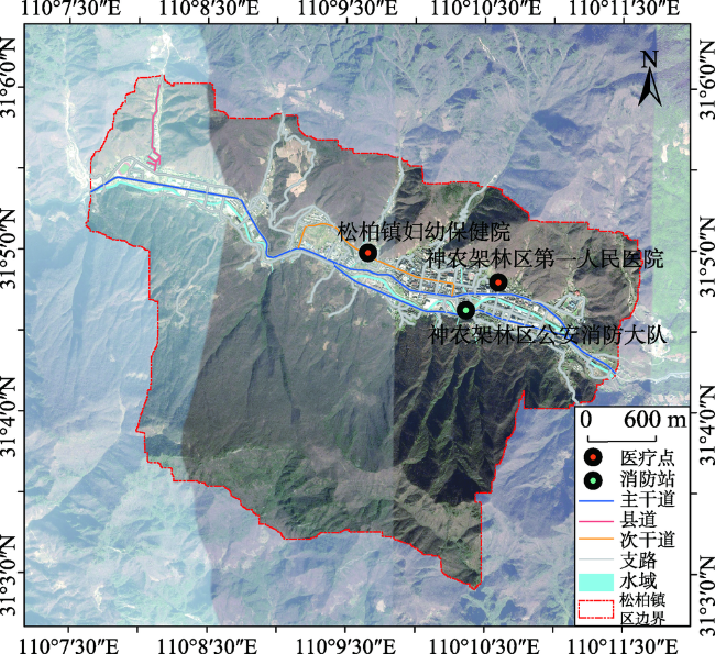
Fig. 1 Fire stations and emergency medical centers of Songbai town图1 松柏镇应急消防设施及应急医疗救助中心区位 |
Tab. 3 Data categories, data labels, and data types表3 研究区数据类别、数据名称与数据类型表 |
| 类别 | 数据名称 | 数据类型 |
|---|---|---|
| 基础分析数据 | 建筑分布图 | 矢量数据 |
| 土地利用分布图 | 矢量数据 | |
| 重大危险源分布图 | 矢量数据 | |
| 地质灾害风险分区图 | 栅格数据1 m×1 m | |
| 洪水灾害风险分区图 | 栅格数据1 m×1 m | |
| 坡度图 | 栅格数据1 m×1 m | |
| 道路网络数据 | 道路图 | 矢量数据 |
| 人口分布数据 | 人口分布图 | 矢量数据 |
| 应急公共 设施数据 | 现状消防站点 | 矢量数据 |
| 现状医疗站点 | 矢量数据 |
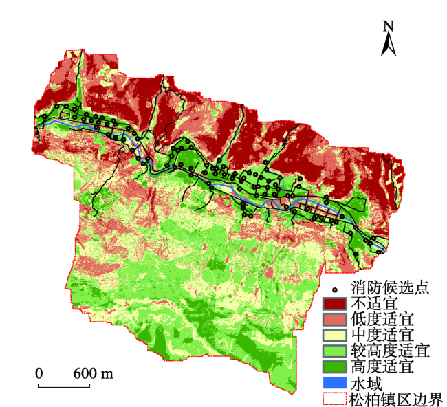
Fig. 2 Suitability evaluation for fire stations图2 松柏镇消防设施用地适宜性评价 |
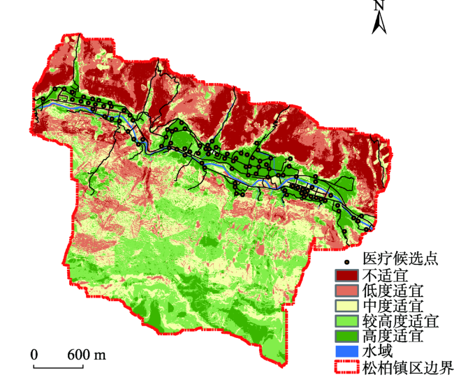
Fig. 3 Suitability evaluation for emergency medical centers图3 松柏镇应急医疗救助中心用地适宜性评价 |
Tab. 4 Comparison of fire station locations generated by the model表4 消防设施选址方案合理性评价结果 |
| 选址 方案 | 设施 数量 | 覆盖 需求数 | 交叉 覆盖率/% | 最大 时间/min | 平均 时间/min | 覆盖人口占总 人口比例/% | 覆盖路径长度占 总长度比例/% | 覆盖建筑面积占总面积比例/% |
|---|---|---|---|---|---|---|---|---|
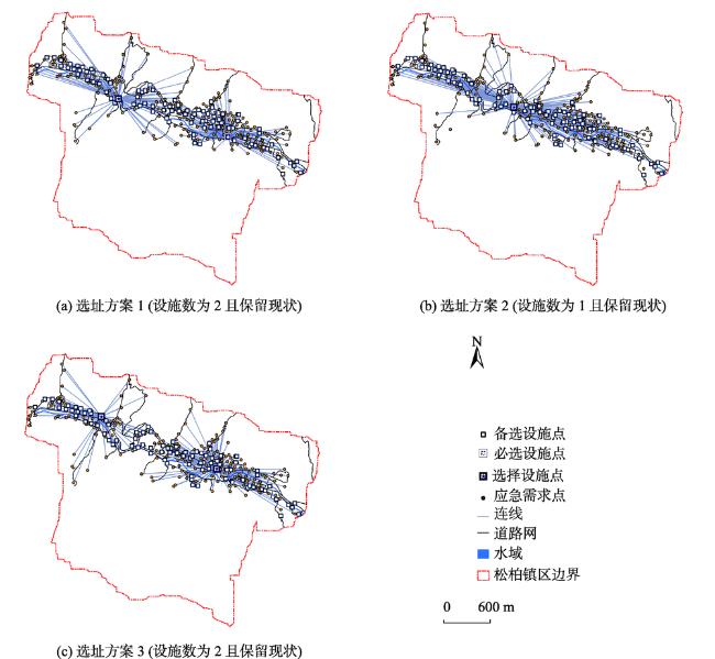
| 选址方案1 (保留现状设施点) | 2 | 210/215 | 70.6 | 4.3 | 1.6 | 97.1 | 95.4 | 96.9 |
| 选址方案2 (不保留现状设施点) | 1 | 190/215 | 0 | 5.1 | 2.6 | 90.9 | 84.4 | 90.0 |
| 选址方案3 (不保留现状设施点) | 2 | 215/215 | 74.3 | 4.9 | 1.5 | 96.9 | 95.4 | 96.7 |
| 现状 | 1 | 162/215 | 0 | 7.5 | 2.8 | 75.44 | 61.37 | 82.26 |
Tab. 5 Comparison of fire station locations generated by the model表5 应急医疗救助中心设施选址方案合理性评价结果 |
| 选址 方案 | 设施 数量/个 | 覆盖 需求数/个 | 交叉 覆盖率/% | 最大 时间/min | 平均 时间/min | 覆盖人口占 总人口比例/% | 覆盖道路长度占 总长度比例/% | 覆盖建筑面积占 总面积比例/% |
|---|---|---|---|---|---|---|---|---|
| 选址方案 (不保留现状设施点) | 1 | 215/215 | 0 | 7.1 | 2.5 | 97.0 | 95.4 | 96.7 |
| 现状 | 2 | 215/215 | 97.2 | 6.6 | 2.3 | 97.0 | 96.2 | 96.9 |
| 妇幼保健院 | 1 | 215/215 | 0 | 6.6 | 2.5 | 96.9 | 96.0 | 95.7 |
| 第一人民医院 | 1 | 189/215 | 0 | 8.2 | 3.0 | 94.7 | 95.2 | 93.6 |
Fig. 4 Comparison of fire station locations generated by the model图4 松柏镇消防设施选址优化结果 |
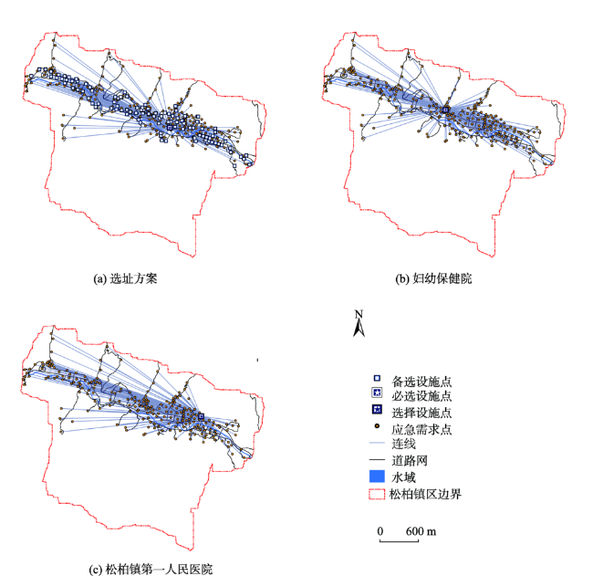
Fig. 5 Comparison of emergency medical center locations generated by the model图5 松柏镇应急医疗救助中心设施选址优化结果 |
The authors have declared that no competing interests exist.
| [1] |
[
|
| [2] |
[
|
| [3] |
[
|
| [4] |
[
|
| [5] |
[
|
| [6] |
|
| [7] |
|
| [8] |
|
| [9] |
|
| [10] |
|
| [11] |
[
|
| [12] |
|
| [13] |
[
|
| [14] |
[
|
| [15] |
|
| [16] |
[
|
| [17] |
[
|
| [18] |
[
|
| [19] |
|
| [20] |
[
|
| [21] |
[
|
| [22] |
[
|
| [23] |
[
|
| [24] |
[
|
| [25] |
[
|
| [26] |
[
|
| [27] |
[
|
| [28] |
|
| [29] |
|
| [30] |
|
| [31] |
|
| [32] |
|
| [33] |
|
| [34] |
住房城乡建设部,国家发展改革委.建标152-2017城市消防站建设标准[S].2017-3-17.
|
| [35] |
国家质量监督检验检疫总局,国家标准化管理委员会.GB/T 35547-2017 乡镇消防队[S].2017-12-29.
|
| [36] |
|
| [37] |
|
/
| 〈 |
|
〉 |