
中国荒漠化分区与时空演变
作者简介:周日平(1965-),女,辽宁岫岩人,高级工程师,主要从事生态环境遥感方面的研究。E-mail: zhou_rp@sina.com
收稿日期: 2018-11-22
要求修回日期: 2019-03-11
网络出版日期: 2019-05-25
基金资助
全国自然资源遥感综合调查与信息系统建设(DD20160077)
Zonation and Spatiotemporal Evolution of China's Desertification
Received date: 2018-11-22
Request revised date: 2019-03-11
Online published: 2019-05-25
Supported by
National Integrated Remote Sensing Survey and Information System Construction, No. DD20160077.
Copyright
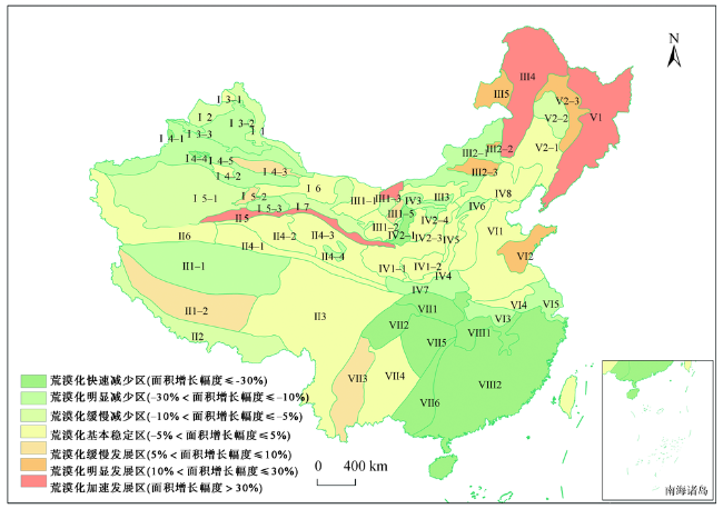
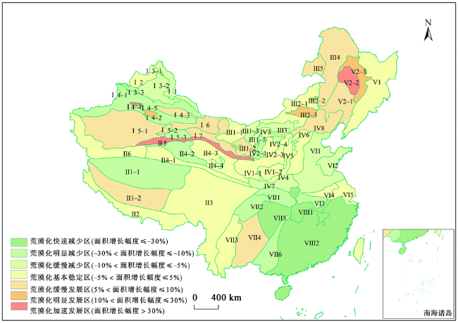
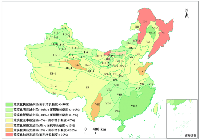
荒漠化被列入威胁人类生存的十大环境与发展问题之一,中国作为世界上荒漠化严重的国家,荒漠化形势十分严峻。本文通过遥感手段,以中国陆域国土范围(除台湾、香港和澳门)的31个省、市、自治区为研究区域,对1975年、2000年与2017年研究区数据进行沙化、盐渍化、水蚀荒漠化专题因子时空演变的综合研究,根据地域分异、发生学及多级序列等原则将将中国划分为8个荒漠-荒漠化区,42个荒漠-荒漠化亚区和36个荒漠-荒漠化小区。以不同时期荒漠化土地类型图为依据,采用荒漠化面积变化量与荒漠化重心迁移轨迹指标进行荒漠化演化分析。为具体说明不同区域荒漠化程度,本研究根据一定时期内荒漠化土地面积增加或减少的百分比将荒漠化演化分为7种类型,通过分析得到不同荒漠化区域的时空演化及不重心迁移,据此提出中国荒漠化的重点治理目标区及防治建议。研究结果表明:① 中国荒漠、荒漠化土地种类较多,重度荒漠化面积25.18×10⁴ km2,占荒漠化总面积的19.59%;② 1975-2017年,中国荒漠化发生明显逆转,与1975-2000年相比,2000-2017年全国的荒漠化强度显著下降,原因是荒漠化加重区面积减少以及荒漠化减弱区面积增加;③ 1975-2000年与2000-2017年,各区内荒漠化重心点坐标迁移具有同向性。本研究在分析荒漠化土地分布、形成和演变机制的基础上,进行了荒漠化分区。通过对不同荒漠化地区的面积百分比变化的比较,得到了不同时期荒漠化的时空演化模式,并分析了荒漠化演化的特点和差异。
周日平 . 中国荒漠化分区与时空演变[J]. 地球信息科学学报, 2019 , 21(5) : 675 -687 . DOI: 10.12082/dqxxkx.2019.180676
Land desertification is one of the most serious eco-environmental problems in the world, and is among the top ten environmental and development problems that threaten the survival of human beings. China has severe desertification, and desertification has greatly affected China's eco-environment and social development. In this context, the research on desertification is of great significance to China. The evolution of desertification is mainly manifested in the change of desertification area, the area change, change of desertification types, vegetation change, and so on. In this paper, the 31 provincial regions of China (excluding Taiwan, Hong Kong, and Macau) were included as the study area. Remote sensing was utilized to study the spatiotemporal evolution of the thematic factors of desertification, salinization, and erosion-induced desertification. Following the principles of regional differentiation, genesis, and multi-level sequences, China was divided into 8 desertification zones, 42 desertification sub-regions, and 36 desertification communities. Based on the desertified land type maps of 1975, 2000 and 2017, we analyzed the desertification evolution by focusing on the changes in the area and gravity center of China’s desertification. According to the percentage of increase or decrease of desertified land area over a certain period of time, the evolution types of desertification can be divided into 7 categories. The present study reveals the current situation of China’s desertification, and analyzes the spatiotemporal evolution and the gravity center movements of different desertification regions. Next, the key target areas and management suggestions of desertification control in China were discussed. Our findings are as follows. (1) There are many kinds of deserts and desertified lands in China, of which the area of severe desertification is 25.18×10⁴ km2, accounting for 19.59% of the total desertification area. (2) From 1975 to 2017, China's desertification has been significantly reversed, and the dynamic characteristics of desertification in 1975-2000 differed from 2000-2017. The intensity of desertification in 2000-2017 significantly reduced as compared to 1975-2000, thanks to the decrease in aggravated areas and increase in weakened areas. (3) The migration value of desertification center of gravity can indirectly reflect the development trend and degree of dynamic change of desertification, the greater the migration, the more significant the difference of desertification change in this region, and the direction of center of gravity migration is the area where desertification area increases. The coordinate migration of desertification barycenter points in different periods has the same orientation.
Tab. 1 Indicator for classifying desertification evolution types表1 荒漠化演化类型分类指标 |
| 荒漠化演化类型 | 一定时期内荒漠化土地面积变化的比例 |
|---|---|
| 加速发展区 | 面积增加>30% |
| 明显发展区 | 面积增加10%~30% |
| 缓慢发展区 | 面积增加5%~10% |
| 基本稳定区 | 面积增加或减少<5% |
| 缓慢减少区 | 面积减少5%~10% |
| 明显减少区 | 面积减少10%~30% |
| 快速减少区 | 面积减少>30% |
Tab. 2 Statistics of the deserts and desertified land types in China in 2017表2 2017年中国荒漠、荒漠化土地类型面积统计结果 |
| 类型 | 沙质荒漠化土地 | 水蚀荒漠化土地 | 盐碱质荒漠化土地 | 沙漠 | 砾漠 | ||||||||
|---|---|---|---|---|---|---|---|---|---|---|---|---|---|
| 重度 | 中度 | 轻度 | 重度 | 中度 | 轻度 | 重度 | 中度 | 轻度 | |||||
| 面积/104km2 | 14.29 | 25.34 | 19.09 | 3.82 | 16.83 | 24.93 | 7.07 | 7.21 | 10.48 | 47.01 | 58.91 | ||
| 面积统计/104km2 | 58.71 | 45.58 | 24.76 | ||||||||||
| 占国土面积 百分比/% | 6.12 | 4.75 | 2.58 | 4.90 | 6.14 | ||||||||
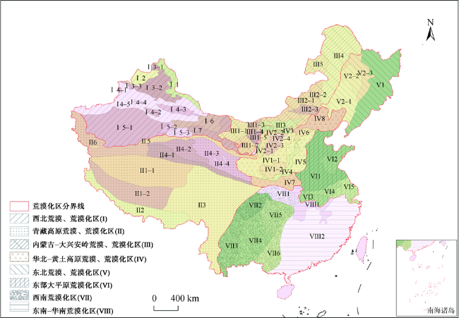
Tab. 3 Zonation of China's deserts and desertification regions表3 全国荒漠、荒漠化分区 |
| 荒漠、荒漠化区 | 荒漠、荒漠化亚区 | 荒漠、荒漠化小区 | |
|---|---|---|---|
| 西北荒漠、荒漠化区(Ⅰ)(地貌主要受古生代-中生代的大地构造控制,形成山岭与盆地的组合体,第四纪以来气候的冷暖波动与日趋干旱,决定了第四纪沉积物的岩性组合与成因类型,形成了中国沙漠、砾漠、盐碱质荒漠化与沙质荒漠化分布最为广泛的地区) | 阿尔泰山荒漠、荒漠化亚区(Ⅰ1) | ||
| 准噶尔西部山地荒漠亚区(Ⅰ2) | |||
| 准噶尔盆地荒漠、荒漠化亚区(Ⅰ3) | 哈巴河荒漠、荒漠化小区(Ⅰ3-1) | ||
| 古尔班通古特沙漠及周缘荒漠、荒漠化小区(Ⅰ3-2) | |||
| 准噶尔盆地西南部荒漠、荒漠化小区(Ⅰ3-3) | |||
| 天山荒漠、荒漠化亚区(Ⅰ4) | 伊犁盆地荒漠、荒漠化小区(Ⅰ4-1) | ||
| 焉耆盆地荒漠、荒漠化小区(Ⅰ4-2) | |||
| 吐哈盆地荒漠、荒漠化小区(Ⅰ4-3) | |||
| 尤尔图斯盆地荒漠、荒漠化小区(Ⅰ4-4) | |||
| 天山山地荒漠、荒漠化小区(Ⅰ4-5) | |||
| 塔里木盆地荒漠、荒漠化亚区(Ⅰ5) | 塔克拉玛干沙漠及周缘荒漠、荒漠化小区(Ⅰ5-1) | ||
| 罗布泊冲湖积平原荒漠化荒漠、荒漠化小区(Ⅰ5-2) | |||
| 库姆塔格沙漠及周缘荒漠、荒漠化亚区(Ⅰ5-3) | |||
| 北山荒漠亚区(Ⅰ6) | |||
| 河西走廊荒漠、荒漠化亚区(Ⅰ7) | |||
| 青藏高原荒漠、荒漠化区(Ⅱ)(青藏高原海拔平均4500米以上,总的地势是西北高、东南低,以低山、丘陵、宽谷、盆地组成平坦、开阔的高原面,纵横伸展着巨大山系,构成高原地貌的格架,现代冰川十分发育,分为6个亚区,是中国沙质荒漠化、砾漠、盐碱质荒漠化分布的主要地区之一) | 藏北高原荒漠、荒漠化亚区(Ⅱ1) | 藏北高原北部荒漠、荒漠化小区(Ⅱ1-1) | |
| 藏北高原南部荒漠、荒漠化小区(Ⅱ1-2) | |||
| 藏南高原荒漠、荒漠化亚区(Ⅱ2) | |||
| 藏东-滇西荒漠、荒漠化亚区(Ⅱ3) | |||
| 青海荒漠、荒漠化亚区(Ⅱ4) | 唐古拉山荒漠、荒漠化小区(Ⅱ4-1) | ||
| 柴达木盆地荒漠、荒漠化小区(Ⅱ4-2) | |||
| 哈拉湖-大板山荒漠、荒漠化小区(Ⅱ4-3) | |||
| 共和、青海湖盆地荒漠、荒漠化小区(Ⅱ4-4) | |||
| 阿尔金山、祁连山荒漠、荒漠化亚区(Ⅱ5) | |||
| 昆仑山荒漠、荒漠化亚区(Ⅱ6) | |||
| 内蒙古-大兴安岭荒漠、荒漠化区(Ⅲ)(内蒙古-大兴安岭荒漠、荒漠化区分为5个亚区,大部海拔在1000米至1500米,局部可达2000米,是中国沙质荒漠化、沙漠分布最为广泛的地区。第四纪地层主要由更新统冲洪积、洪积物和全新统风积层、湖积层、冲洪积层组成) | 阿拉善高原荒漠、荒漠化亚区(Ⅲ1) | 巴丹吉林沙漠及周缘荒漠、荒漠化小区(Ⅲ1-1) | |
| 腾格里沙漠及周缘荒漠、荒漠化小区(Ⅲ1-2) | |||
| 海里与博格台沙漠及周缘荒漠、荒漠化小区(Ⅲ1-3) | |||
| 乌兰布和沙漠及周缘荒漠、荒漠化小区(Ⅲ1-4) | |||
| 亚玛雷克沙漠及周缘荒漠、荒漠化小区(Ⅲ1-5) | |||
| 内蒙古东部高原荒漠、荒漠化亚区(Ⅲ2) | 内蒙古波状高原荒漠、荒漠化小区(Ⅲ2-1) | ||
| 乌珠穆沁沙地荒漠化小区(Ⅲ2-2) | |||
| 浑善达克沙地荒漠化小区(Ⅲ2-3) | |||
| 阴山荒漠、荒漠化亚区(Ⅲ3) | |||
| 大兴安岭荒漠化亚区(Ⅲ4) | |||
| 海拉尔盆地荒漠化亚区(Ⅲ5) | |||
| 荒漠、荒漠化区 | 荒漠、荒漠化亚区 | 荒漠、荒漠化小区 | |
| 黄土高原荒漠、荒漠化亚区(Ⅳ1) | 黄土高原沟壑荒漠化小区(Ⅳ1-1) | ||
| 黄土丘陵沟壑荒漠化小区(Ⅳ1-2) | |||
| 鄂尔多斯高原荒漠、荒漠化亚区(Ⅳ2) | 宁夏河东高原荒漠化小区(Ⅳ2-1) | ||
| 库布齐沙漠及周缘荒漠、荒漠化小区(Ⅳ2-2) | |||
| 毛乌素沙地荒漠化小区(Ⅳ2-3) | |||
| 鄂尔多斯高原东部荒漠化小区(Ⅳ2-4) | |||
| 银川-河套平原荒漠、荒漠化亚区(Ⅳ3) | |||
| 汾渭盆地荒漠化亚区(Ⅳ4) | |||
| 吕梁山-太行山荒漠化亚区(Ⅳ5) | |||
| 大同-阳原盆地荒漠化亚区(Ⅳ6) | |||
| 秦岭山地荒漠化亚区(Ⅳ7) | |||
| 燕山荒漠化亚区(Ⅳ8) | |||
| 小兴安岭、长白山、三江平原荒漠化亚区(Ⅴ1) | |||
| 松辽平原荒漠化亚区(Ⅴ2) | 科尔沁沙地及周边荒漠化小区(Ⅴ2-1) | ||
| 松嫩沙地及周边荒漠化小区(Ⅴ2-2) | |||
| 松辽平原东北部荒漠化小区(Ⅴ2-3) | |||
| 黄淮海平原荒漠化亚区(Ⅵ1) | |||
| 胶东半岛荒漠化亚区(Ⅵ2) | |||
| 江淮、苏北丘陵南部荒漠化亚区(Ⅵ3) | |||
| 江淮、苏北丘陵北部荒漠化亚区(Ⅵ4) | |||
| 长江下游平原荒漠化亚区(Ⅵ5) | |||
| 米仓山-大巴山荒漠化亚区(Ⅶ1) | |||
| 四川盆地荒漠化亚区(Ⅶ2) | |||
| 滇中-川南荒漠化亚区(Ⅶ3) | |||
| 滇东-黔西荒漠化亚区(Ⅶ4) | |||
| 川东南-黔东荒漠化亚区(Ⅶ5) | |||
| 广西荒漠化亚区(Ⅶ6) | |||
| 长江中下游荒漠化亚区(Ⅷ1) | |||
| 东南-华南沿海平原及丘陵荒漠化亚区(Ⅷ2) | |||
Fig. 1 Zonation map of China's desertification in 2017图1 2017年中国荒漠化分区 |
Fig. 2 Evolution pattern of China's desertification during 1975-2017 (based on the zonation)图2 1975-2017年中国荒漠化演化(基于荒漠化分区) |
Fig. 3 Evolution pattern of China's desertification during 1975-2000 (based on the zonation)图3 1975-2000年中国荒漠化演化(基于荒漠化分区) |
Fig. 4 Evolution pattern of China's desertification during 2000-2017 (based on the zonation)图4 2000-2017年中国荒漠化演化(基于荒漠化分区) |
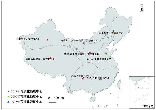
Fig. 5 Gravity center movements of China's desertification zones during 1975-2017 (based on the zonation)图5 1975-2017年中国荒漠化土地重心迁移(基于荒漠化分区) |
Tab. 4 Movement trajectories of the gravity centers of China's different desertification zones during 1975-2017表4 1975-2017年中国荒漠化区重心迁移轨迹 |
| 荒漠化区 | 荒漠化重心 迁移方向 | 荒漠化重心 迁移量/km | 荒漠化区 | 荒漠化重心 迁移方向 | 荒漠化重心 迁移量/km |
|---|---|---|---|---|---|
| 西北荒漠、荒漠化区(Ⅰ) | 东南 | 12.53 | 东北荒漠、荒漠化区(Ⅴ) | 西南 | 58.45 |
| 青藏高原荒漠、荒漠化区(Ⅱ) | 西南 | 26.01 | 东部大平原荒漠化区(Ⅵ) | 西北 | 49.78 |
| 内蒙古-大兴安岭荒漠、荒漠化区(Ⅲ) | 东北 | 25.84 | 西南荒漠化区(Ⅶ) | 西南 | 95.88 |
| 华北-黄土高原荒漠、荒漠化区(Ⅳ) | 东北 | 7.37 | 东南-华南荒漠化区(Ⅷ) | 东北 | 75.39 |
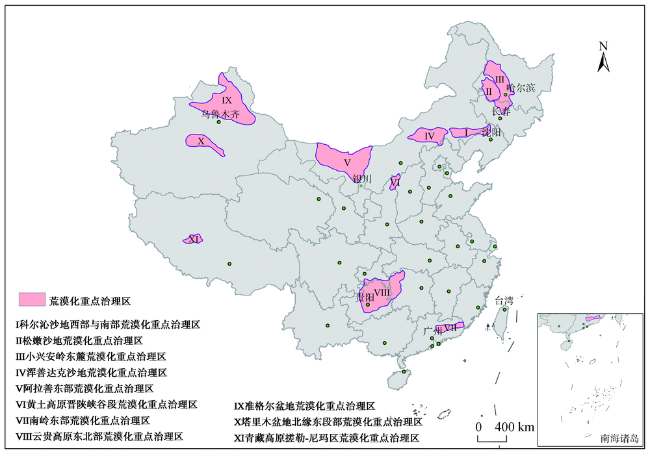
Fig. 6 Map of key areas for the desertification management of China in 2017图6 2017年中国荒漠化重点治理区分布 |
The authors have declared that no competing interests exist.
| [1] |
[
|
| [2] |
[
|
| [3] |
[
|
| [4] |
[
|
| [5] |
[
|
| [6] |
[
|
| [7] |
[
|
| [8] |
[
|
| [9] |
[
|
| [10] |
[
|
| [11] |
[
|
| [12] |
[
|
| [13] |
[
|
| [14] |
[
|
| [15] |
[
|
| [16] |
[
|
| [17] |
[
|
| [18] |
[
|
| [19] |
[
|
| [20] |
[
|
| [21] |
|
| [22] |
[
|
| [23] |
[
|
| [24] |
[
|
| [25] |
[
|
| [26] |
|
| [27] |
|
| [28] |
[
|
| [29] |
|
| [30] |
[
|
| [31] |
[
|
| [32] |
[
|
/
| 〈 |
|
〉 |